Stormtrack
02-05-2020_la_ms_al_fla
Morphtato 31-Jan-20 01:25 PM
Krietz 31-Jan-20 05:13 PM
Linear
453Braxton 01-Feb-20 04:53 PM
A southerly flow will be in place over the forecast area at the beginning of the period and brings increasing deep layer moisture in the area ahead of the approaching front, with surface dewpoints increasing to 65 to 68F and precipitable water values increasing to 1.5-1.8 inches. A series of shortwaves continues to move across the area Wednesday into Wednesday night as the front approaches resulting in broad and potentially strong deep layer lifting over the forecast area. SBCAPE values of 700-1000 J/kg will be present during peak heating on Wednesday and a 40-50 knot 850 mb jet results in 0-1 km Helicity values around 200 m2/s2. 0-6 km Bulk Shear values of 55-70 knots will also be present and supercell composite parameter values will be 5 to 8, indicating a significant potential for supercell development. Effective layer Significant Tornado Parameter values of 1.0-3.0 will also be present with the higher values over the southern and central portions of the area and also confined to mainly from mid Wednesday morning into Wednesday afternoon. This may change due to timing uncertainties, but considering all of these parameters for this environment, severe storm development looks possible including the potential for isolated tornadoes. The potential for severe weather development will wane Wednesday night with the loss of daytime heating, ending with the frontal passage. Another uncertainty is that the series of shortwaves moving across the region could result in a somewhat messy convective pattern, or organize into a quasi-linear convective pattern, but this will have to be ascertained later.
NWS Mobile about Wednesday
Krietz 02-Feb-20 10:52 AM
derecho @453Braxton
Glen Heinz (Greenville, SC) 02-Feb-20 12:28 PM
Come on Nick it's Dixie, we expect it. (edited)
Krietz 02-Feb-20 12:43 PM
true glen
Glen Heinz (Greenville, SC) 03-Feb-20 11:43 AM
trending down.
Noir 03-Feb-20 12:27 PM
Whole event is.
Morphtato 04-Feb-20 12:40 AM
Slight expanded by a sizable margin in the D2 update. 5% TOR
453Braxton 04-Feb-20 07:09 AM
Yep, supercells also now mentioned in the discussion.
Models appear to favor a few convective scenarios which may play out on Wednesday with 1) initial storm development over LA near the boundary in proximity to stronger forcing to the west/northwest, and 2) potential warm-sector development farther east in southern MS in between I-10 and I-20 near a maritime front. Forecast hodographs vary slightly between different model guidance but a general supercell-wind profile would support the stronger warm-sector initiating storms to develop into supercells with all severe hazards possible. The strengthening 700-mb flow during the day lends some confidence in storm evolution featuring a mix of cells and convective bands. As storms move east during the evening and overnight, a gradual decrease in instability will probably favor the greatest severe risk becoming confined closer to the coastal plain as the activity moves into eastern AL/western GA and the FL Panhandle.
453Braxton 04-Feb-20 02:19 PM
18z HRRR thonk
Hank 8
thonk 7
Brad Arnold (Huntsville, AL) 04-Feb-20 04:23 PM
18z hrrr is a full blown outbreak
453Braxton 04-Feb-20 04:25 PM
Yeah, pretty intense run
453Braxton 04-Feb-20 04:56 PM
Some global consensus shows some potential for some coastal convection, but there remains a good feed of low-level Theta E across central to southwest Mississippi & northeast Louisiana to serve as an impetus for severe weather development along the Mississippi River around noon & to spread east-northeast through the afternoon to evening. Some hi-res guidance indicates even more 
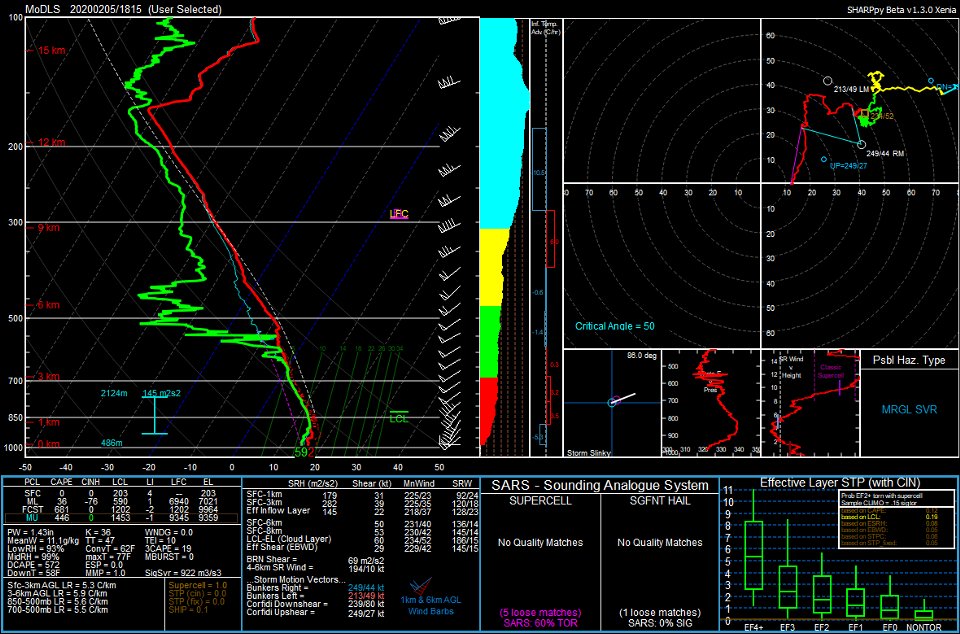
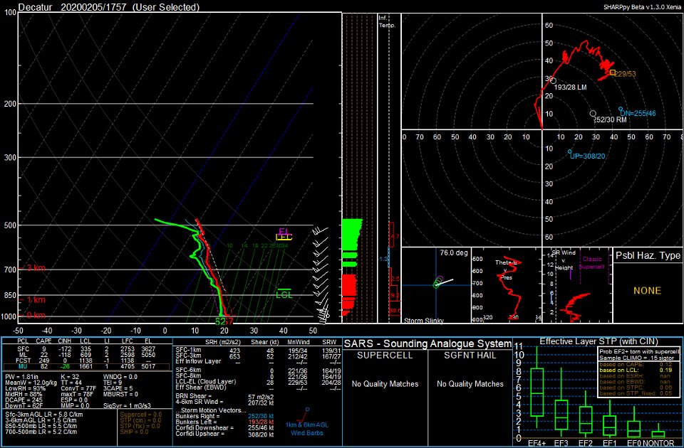
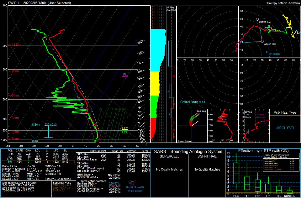
concerning juxtaposition of parameters, with some experimental HRRR runs showing significant tornado parameter (STP) approaching 6+, bullseye over southwest Mississippi & northeast Louisiana & central portions of ArkLaMiss on the northern gradient & strong updraft helicity swaths. This environment will be very anomalously destabilized (i.e. 1000-1500+ MLCAPE) & sheared. Strong clockwise curving hodographs will lead to supercell & tornado potential, with some increasing potential for even more significant severe weather & upgrade in future outlooks possible. For now, in 
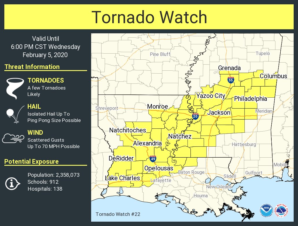
conjunction with SPC, expanded the "Slight" risk area for severe weather further northwest across the Delta, with "Marginal" risk area across the far northwest Delta. All modes of severe weather are possible, including damaging winds of 60-70mph, large hail of quarter to golf ball size & tornadoes. Keep a close eye on future outlooks for any increase in severe weather potential & upgrades in the HWO/graphics.
Interesting AFD from NWS Jackson, MS thonk
(edited)
KFC Chicken 04-Feb-20 07:38 PM
Guys this is going to be 100% linear no question whatsoever
troll 7
Morphtato 04-Feb-20 11:56 PM
Pretty much status quo for 06z D1, but could change later once some uncertainties get resolved.
UNCERTAINTY REGARDING INSTABILITY AS WELL AS QUESTIONS CONCERNING THE POSITION OF THE FRONT AND ANY EFFECTS OF ANTECEDENT PRECIPITATION PRECLUDE INTRODUCING HIGHER SEVERE PROBABILITIES WITH THIS OUTLOOK.
Chris Maupin 05-Feb-20 01:15 AM
Yooo. Tomorrow/today is gonna be an interesting day for Dixie. Sleep tight.
Brad Arnold (Huntsville, AL) 05-Feb-20 03:09 AM
Today feels like Yazoo City, MS 2.0
Chris Maupin 05-Feb-20 08:28 AM
Morning
Warm sector stayed pretty charged.
Chris Maupin 05-Feb-20 08:44 AM
Cape values gonna get crazy?
453Braxton 05-Feb-20 10:23 AM
ENH issued
10% hatched TOR risk
12Z CAM SOLUTIONS SUGGEST THAT CONVECTION WILL FIRST FORM OVER CENTRAL LA AS THE LARGE-SCALE FORCING APPROACHES. LOW-LEVEL VERTICAL SHEAR WILL PROMOTE SOME RISK OF DISCRETE SUPERCELLS, ALONG WITH MORE COMPLEX BOWING STRUCTURES. FORECAST HODOGRAPHS INDICATE FAVORABLE PARAMETERS FOR A FEW TORNADOES, INCLUDING THE RISK OF STRONG TORNADOES, AS ACTIVITY BUILDS NORTHEASTWARD ACROSS THE ENH RISK AREA. DAMAGING WIND GUSTS AND PERHAPS SOME HAIL ARE ALSO POSSIBLE IN THE STRONGEST CELLS.
Chris Maupin 05-Feb-20 10:31 AM
Hail core heading into LA near Deweyville. Lots of lightning.
looks like it's splitting
WeathermanEd (Chicago) 05-Feb-20 11:48 AM
A tornado watch has been issued for parts of Louisiana and Mississippi until 6 PM CST
453Braxton 05-Feb-20 11:51 AM
70/40
Chris Maupin 05-Feb-20 11:57 AM
@KFC Chicken I didn't see this last night. I would have told you I'll take your money
WeathermanEd (Chicago) 05-Feb-20 02:05 PM
UAH student, staff, and faculty are conducting severe weather operations across North AL today. Here are the weather balloon soundings launched at noon today from Courtland, Decatur, and UAH. #HUNwx #alwx
Jeff House (Chattanooga, TN) 05-Feb-20 02:34 PM
Well now. Little bit of low level CAPE after all. Still that marine WF farther south looks most interesting in Miss. Cell rooted may go a while, or not. Depends on 700 temps vs being on boundary (edited)
Morphtato 07-Feb-20 12:30 AM
NWS JAN storm survey teams have confirmed four other tornadoes (one EF1 and three EF2s) that were produced from yesterdays storms including the long track EF2 Jasper/Lauderdale counties tornado that produced damage and had peak winds of 125mph! #mswx