Stormtrack
02-12-2020_la_ms_al
WildishSlambino 09-Feb-20 10:09 AM
CanadianStormChaser 09-Feb-20 10:09 AM
πŸ‘€
Can Dixie pull it off again? Find out during our next event!
WildishSlambino 09-Feb-20 10:12 AM
Haha, hopefully this one is better than the last.
John Choquette (Edmond, OK) 09-Feb-20 10:24 AM
next time on dragonball dixie we look forward to the next dixie events!
453Braxton 09-Feb-20 10:25 AM
Woah, where did this come from lol
SPC went straight to 30% thonk
Shane Adams (Fort Worth, TX) 09-Feb-20 10:29 AM
Typical Dixie time of year. Fast-moving, messy systems with tornadoes that look like smoke going up into low cloud decks.
Jeff House (Chattanooga, TN) 09-Feb-20 11:56 AM
Lots of flooding in the area too. I'll pass. Probably be slammed at work anyway. Seriously recommend sitting out this one.
AverageBreh 09-Feb-20 12:13 PM
Dixie awakens!
Doppler 09-Feb-20 01:48 PM
Even if I lived in the center of that I wouldn't chase outside my county
<<𝕭𝖔𝖇>> γƒœγƒ– 09-Feb-20 02:31 PM
Still expecting some kind of organized squall/Quasi-linear system with this, as the last 3-4 have shown. Still winter time Dixie Alley, but shocked they hopped on a 30% on Day 4 out of the blue like that. Believe there were some earlier model indications, but I think we'll get a better idea in days to come. Won't have time to really track it, but could snag some pics as it passes through here.
derecho 3
<<𝕭𝖔𝖇>> γƒœγƒ– 09-Feb-20 02:55 PM
Watching DIXIE ALLEY next Wednesday for tornado outbreak potential as a potent upper-level storm system is forecast to dig deep into Texas/northern Mexico before ejecting east across southern U.S. TODAY: evening/overnight supercell storms possible northeast TX into southeast OK...
Likes
213
East 7
If that comes true, I'll hear a midnight tube pass by from a monster embedded HP sup and rip the roof off my apartment
Yao 1
RidleyTheSpacePirate34 09-Feb-20 04:43 PM
Just another day at Dixie with HP sup dropping a 2 am tube... apparently.
<<𝕭𝖔𝖇>> γƒœγƒ– 09-Feb-20 08:28 PM
has been pretty active, especially with Jan 11th here. Don't remember getting something that bad this early in the year, wind gusts were topping 70, and got a tornado warning on-top of that, power went out for 3 hours. Although these systems have sloppy storm modes, a QLCS, that one random discrete supercell ahead of it, these systems have caused impacts, especially as well in flooding, which makes me concerned about this pattern, especially for North GA. Rivers near here are still at minor flooding stage, and saturated soils, with even subsevere wind gusts can pull what Atlanta did on I-285 and have a tree smash right into a car on your commute to work. Dixie alley trees are no joke, definitely dangerous if a higher-end wind threat materializes like 1/11 (edited)
NWS peachtree as well said they already had to make several water rescues, and they're concerned with even more flooding, not a helping factor in any severe weather event
RidleyTheSpacePirate34 10-Feb-20 12:12 AM
Yeah agreed with that. My father told me about the situation in Knoxville, and I looked up on news. Both severe weather and flooding from extra rain are horrible combination.
<<𝕭𝖔𝖇>> γƒœγƒ– 10-Feb-20 06:36 AM
<<𝕭𝖔𝖇>> γƒœγƒ– 10-Feb-20 06:09 PM
High-res EURO showing a pretty solid EML ahead of the system in portions of MS/AL
Matthew Harding 10-Feb-20 07:30 PM
You’re gonna need a boat to chase these storms Wednesday night.
πŸ‘ 4
Jeff House (Chattanooga, TN) 10-Feb-20 07:57 PM
Gonna need a bunch of sun to overcome mid-level temps. Oh it's Feb. If it's not a Gulf MCS, capped low clouds wastes an excellent wind field. Breaks of sun late could be too little too late. Good for residents though. Too much high water to chase anyway.
RTC 11-Feb-20 01:05 AM
Day 2 SLGT, enhanced dropped
5% tor
THERE IS   CONSIDERABLE UNCERTAINTY REGARDING THE COVERAGE OF WIND DAMAGE BASED   ON AVAILABLE INSTABILITY DEPICTED IN THE MODELS. THE EC HAS SHOWN   THE GREATEST RUN-TO-RUN CONSISTENCY IN THE EVOLUTION OF THE CYCLONE   BUT A GENERAL REDUCTION IN INSTABILITY IS EVIDENT IN MODEL GUIDANCE.   THE INSTABILITY CONCERNS/UNCERTAINTY SUGGEST A LOWERING OF SEVERE   PROBABILITIES COMPARED TO PREVIOUS FORECASTS MAY BE WARRANTED.
(edited)
RTC 11-Feb-20 11:12 AM
12z HRRR
Sounding a tiny bit ahead of the line that's shown
<<𝕭𝖔𝖇>> γƒœγƒ– 11-Feb-20 02:01 PM
Looks like a high shear low cape setup
Not seeing too much with tommorow unless the models pick back up on it. Some models still remaining consistent but showing less instability (edited)
<<𝕭𝖔𝖇>> γƒœγƒ– 11-Feb-20 05:12 PM
Think local lifting with some warm air advection in the warm-sector ahead of the front could attempt to fuel some convection ahead of the front, but as Jeff said, mid-level temps. Once a line gets going I think it'll sustain itself with some embedded wind damaging threat and secondary tornado threat, even in the marginally favorable parameters until the end of that forecast period. High shear low cape setup for winter time Dixie, you're not gonna see that "fat" CAPE, but I think it'll fuel a QLCS like line. (edited)
πŸ‘ 1
Glen Heinz (Greenville, SC) 11-Feb-20 05:51 PM
LR are crap
<<𝕭𝖔𝖇>> γƒœγƒ– 11-Feb-20 06:02 PM
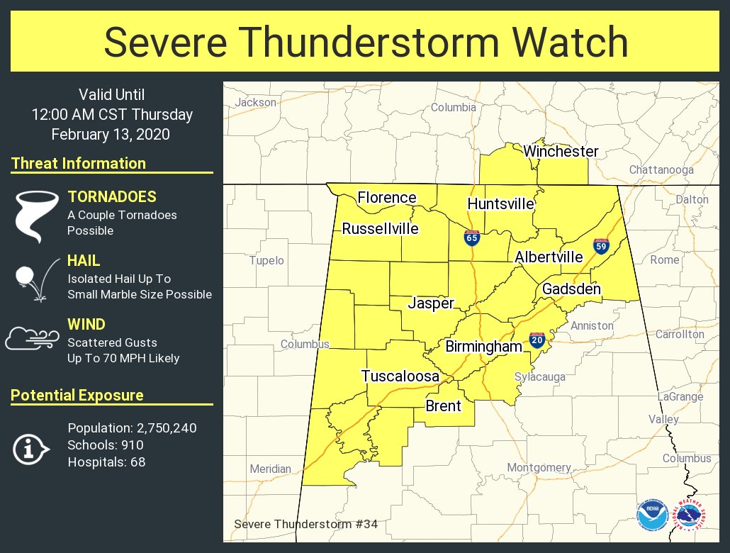
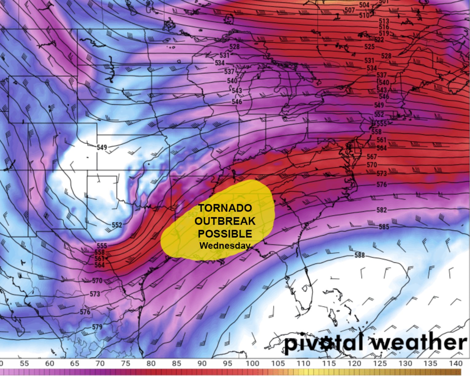
The cold front is expected to enter northwest Georgia on Wednesday night, with PoPs quickly increasing to categorical in the area ahead of the front during the overnight hours Wednesday into Thursday morning. A low instability/high shear environment is anticipated as this front enters the area. With CAPE values of 400-600 J/kg, low- level shear of 30-40 kts, and deep layer shear of 70-80 kts, a QLCS line is expected to be the main convective mode associated with this 
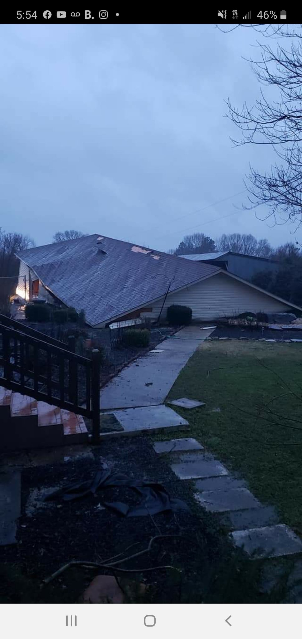
system. Damaging wind gusts will be the primary hazard associated with this line as it enters the area, and brief tornadoes cannot be ruled out. With precipitable water values remaining high, locally heavy rainfall will also be likely.
derecho 2
Chris Maupin 11-Feb-20 10:04 PM
I just am not seeing it.
Minimal baroclinicity, not much in the environment to bring the modified air sitting just offshore inland, no lapse rate plume upstream right now to make a low CAPE boundary layer more punchy, speed max well aloft
And a surface high holding on at 00Z . Said this in the other channel, this will just be educational for me if it verifies.
The winter rains in the SW seem to have utterly squashed the synoptic environment aloft.
RTC 12-Feb-20 01:06 AM
The air mass ahead of the front and low will initially be cool/stable, but gradual destabilization will occur by late afternoon and evening. In addition, midlevel lapse rates will be poor, reducing instability. That said, shear profiles will be strong, and conditionally favorable for a supercell and/or QLCS.
Chris Maupin 12-Feb-20 10:16 AM
Oh wow. So I didn’t screw that one up. Damn hype-sters
<<𝕭𝖔𝖇>> γƒœγƒ– 12-Feb-20 10:48 AM
Crappy lapse rates, next
KFC Chicken 12-Feb-20 02:17 PM
lol I never paid attention to this event, took one look and just didn’t look again after that
<<𝕭𝖔𝖇>> γƒœγƒ– 12-Feb-20 03:03 PM
Today's pre-frontal convection in a nutshell. Spinning shrimps then they do much of nothing
Morphtato 12-Feb-20 03:05 PM
TOR on that shrimp now.
<<𝕭𝖔𝖇>> γƒœγƒ– 12-Feb-20 03:06 PM
I said that too soon
Morphtato 12-Feb-20 03:06 PM
Yao
<<𝕭𝖔𝖇>> γƒœγƒ– 12-Feb-20 03:08 PM
A 10 minute tornado warning from an initiated Shrimp less than an hour old, okay Dixie
Okay
Dixie pulls it off again
Morphtato 12-Feb-20 04:37 PM
A severe thunderstorm watch has been issued for parts of Alabama and Tennessee until 12 AM CST
<<𝕭𝖔𝖇>> γƒœγƒ– 12-Feb-20 06:47 PM
Oh how this devolved so quickly
Morphtato 12-Feb-20 06:47 PM
@simpsonwhnt garage down on Lauderdale County 375 in Green Hill
Chris Maupin 12-Feb-20 06:51 PM
Looks like straight line
<<𝕭𝖔𝖇>> γƒœγƒ– 12-Feb-20 06:58 PM
I'm ready for Spring
AverageBreh 12-Feb-20 08:35 PM
Absolutely.
Morphtato 12-Feb-20 08:38 PM
oldman
RTC 12-Feb-20 09:26 PM
Spring cannot come soon enough, and considering the top analogs it should be as if not more interesting than spring 2019
πŸ‘€
AverageBreh 12-Feb-20 10:03 PM
I could deal with more localtubes and early season outbreaks.
Chris Maupin 12-Feb-20 10:33 PM
Well it will be interesting to see if you have to wait long.
Fresh lapse lapse rate plume building over OK
πŸ‘€ 3
Baroclinicity is in place at mid levels.
I will be curious to see if this translates to some speed max’s in the next 24 hours
The surface low from the afternoon moved quickly into Appalachia
Chris Maupin 13-Feb-20 08:39 AM
Yup, 500 mbar speed max over N TX and OK this morning
physics works
Morphtato 13-Feb-20 06:54 PM
HUN issues Public Information Statement (PNS) at Feb 13, 4:24 PM CST ...NWS Damage Survey for 02/12/2020 Tornado Event... https://t.co/ObWyLzSzv2