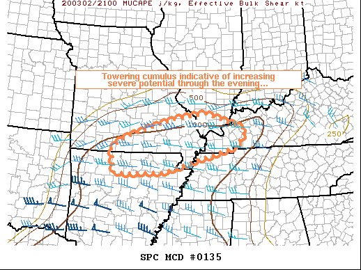
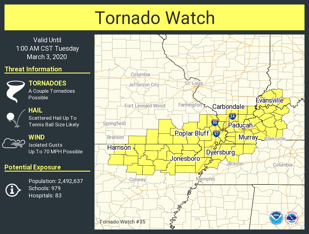
Multiple tornado warnings (and a preliminary confirmed tornado) ongoing in the area highlighted above this evening. Two features standing out to me the most are the observed mid level lapse rates - over 8.0 c/km - and 0-3km helicity - over 300 m2/s2. Very impressive environme...
Norman02-Mar-20 07:21 PM
<<𝕭𝖔𝖇>> ボブ02-Mar-20 07:26 PM
Steep lapse rates, I welcome you back, I have missed you
Norman02-Mar-20 07:29 PM
WOW new scan
RidleyTheSpacePirate3402-Mar-20 07:32 PM
Oooh! Nice sup
<<𝕭𝖔𝖇>> ボブ02-Mar-20 07:32 PM
This is eye-candy for this early into the Spring FR
RidleyTheSpacePirate3402-Mar-20 07:33 PM
That lightened up my mood after 2 exams today.
Jim Martin02-Mar-20 07:34 PM
that storm in Kentucky is going to cross US Hwy 41 north of Hopkinsville soon
<<𝕭𝖔𝖇>> ボブ02-Mar-20 07:34 PM
this TOR ahead of this line is still surprising me, but seems it's less than ideally surface based, nothing much until you go higher up in the tilts
Jim Martin02-Mar-20 07:36 PM
Paducah NEXRAD may be having issues
Norman02-Mar-20 07:37 PM
RidleyTheSpacePirate3402-Mar-20 07:39 PM
THICC HP is THICC(edited)
Jim Martin02-Mar-20 07:40 PM
storm north of Hopkinsville may be cycling
<<𝕭𝖔𝖇>> ボブ02-Mar-20 07:40 PM
Don't think this one will be with us much longer
Jim Martin02-Mar-20 07:42 PM
looks like it is trying to wrap back around again Cameron
Norman02-Mar-20 07:43 PM
I think those sups in MO will do something before the nights over.
<<𝕭𝖔𝖇>> ボブ02-Mar-20 07:43 PM
Been doing this for 4 hours, hasn't really gotten itself together enough
Sups to the west still dropping large hail regardless, definitely gonna be an overnight hail/damaging wind threat, something to watch for even once the tornado risk begins to diminish
RidleyTheSpacePirate3402-Mar-20 07:46 PM
Yeah, but I don't trust storms in South sometimes.
Norman02-Mar-20 07:46 PM
This is were the tornado threat begins
*in the past hour
RidleyTheSpacePirate3402-Mar-20 07:47 PM
And things sometimes take a while to get act together.
<<𝕭𝖔𝖇>> ボブ02-Mar-20 07:47 PM
Those cells to the west are going to have the greatest chance at doing something, and have already dropped 2 tornadoes at least
Norman02-Mar-20 07:47 PM
Tornado threat isn’t going to die off shortly, probably within the next 2-4 hrs or so
Paducah radar tho
<<𝕭𝖔𝖇>> ボブ02-Mar-20 07:48 PM
Looking at the wrong stuff, losing track lol
John Humphress
Norman02-Mar-20 07:49 PM
LARGE TORNADO IN MO
@RidleyTheSpacePirate34
Jim Martin02-Mar-20 07:50 PM
where is that located Norman?
Norman02-Mar-20 07:50 PM
Tornado Warned storm in MO
RidleyTheSpacePirate3402-Mar-20 07:50 PM
What the...? Like I said they still could pull off shenanigan.
Jim Martin02-Mar-20 07:51 PM
and the storm north of Hopkinsville is trying again
Norman02-Mar-20 07:51 PM
As I said, this is were the fun begins LMAO
RidleyTheSpacePirate3402-Mar-20 07:51 PM
Popcorn time... I guess.
453Braxton02-Mar-20 07:51 PM
I'd be very careful calling that a "large tornado", very likely just a wall cloud based on the stream I am watching, which has a clearer view @Norman(edited)
JT02-Mar-20 07:51 PM
I agree with Braxton
RidleyTheSpacePirate3402-Mar-20 07:52 PM
Probably hard to see. That's why I don't trust storms here.
Norman02-Mar-20 07:52 PM
Mario said it was a large tornado on the ground in Pathfinder
JT02-Mar-20 07:52 PM
You've got a treeline covering ground visual
Norman02-Mar-20 07:52 PM
He’s been watching the stream for a while
Don’t know if that’s 100% but don’t shoot the messenger
<<𝕭𝖔𝖇>> ボブ02-Mar-20 07:52 PM
Ground-scrapping wallclouds and trees, It's spring
453Braxton02-Mar-20 07:53 PM
Yeah, I know Norman, but still, it's dark, treeline is blocking the horizon, and lightning is the only thing allowing people to see these storms lol
JT02-Mar-20 07:53 PM
Just look at what dixie setups do with moisture
Norman02-Mar-20 07:53 PM
Yes Ik James
<<𝕭𝖔𝖇>> ボブ02-Mar-20 07:54 PM
Looks like it's going GTG or has been, haven't really checked in a bit, but definitely solid, that thing is rotating, and it definitely could drop a tornado if it hasn't already
RidleyTheSpacePirate3402-Mar-20 07:55 PM
I've seen too many dixie set ups. These storms like to drag their scuddy wall clouds across ground.
Our M3V team launched a sounding at 12:58 AM from the I-65/Old Hickory Blvd interchange as the tornado was ongoing in east Nashville. This was a rather exceptional high-shear/low-CAPE tornado. A hodograph will be shared later after wind data are QC’ed (disregard SRH). #tnw...
BREAKING...survey update from Putnam Co.:
-EF-4 tornado (175 mph winds)
-18 fatalities, 88 injuries, 3 still missing
-Path and width will be determined in coming days
-First violent tornado in @NWSNashville area since 4/10/2009