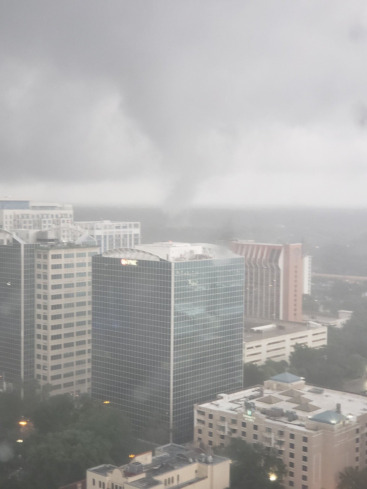
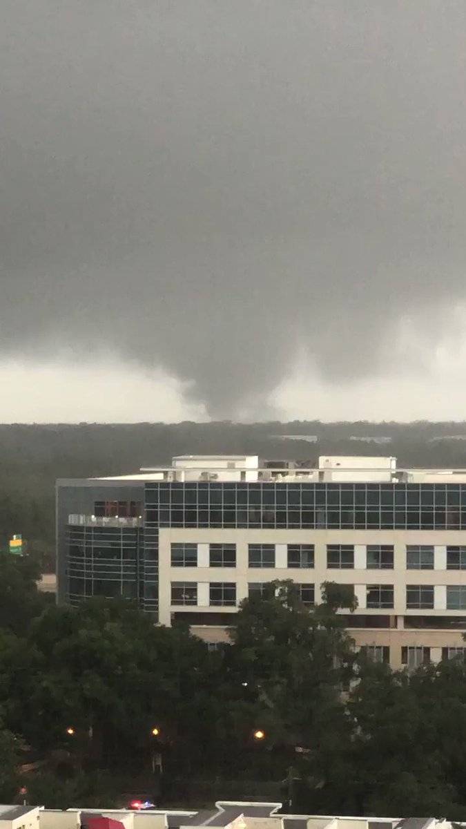
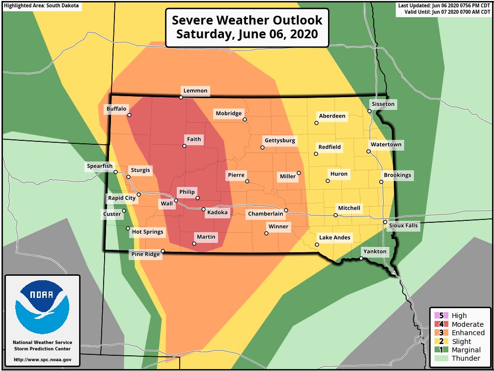
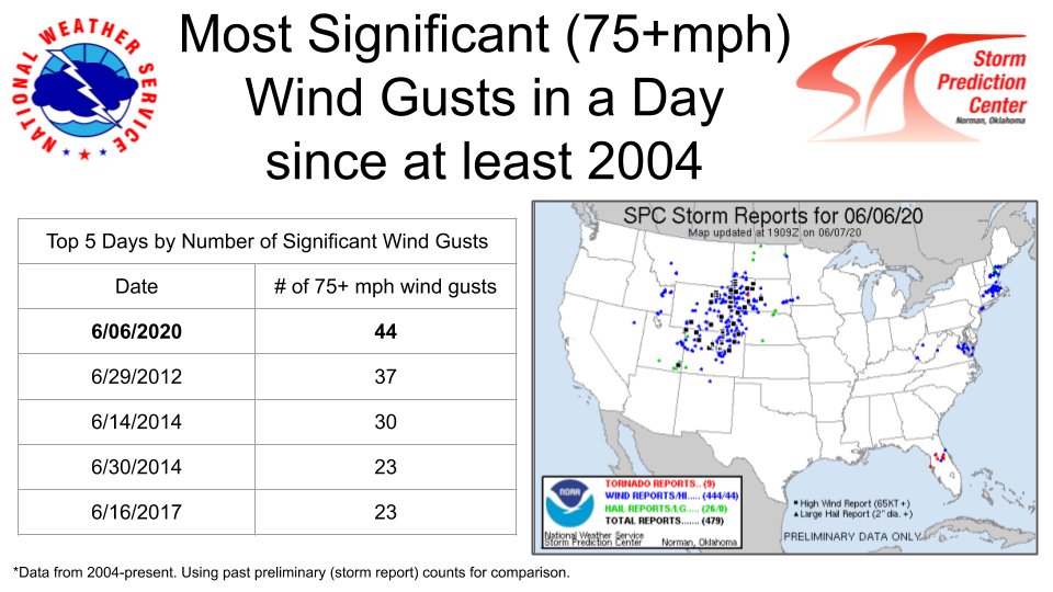
Guild icon
Stormtrack
EVENT ARCHIVE / 06-06-2020_sd_nd_wy
Avatar
Peter Potvin (Pembroke, ON) ✱ 04-Jun-20 12:10 PM
Avatar
Joey Prom (Lafayette, IN) 04-Jun-20 12:22 PM
I am looking for a chase partner for this weekend. Or just someone willing to let me caravan with them. I currently live in the twin cities. I have a car and no time commitments, I can leave any time and chase as long as needed. I don't have data, so chasing solo outside of my normal area is not a good idea for me. Just let me know if any of you are interested. I got tested 2 days ago and it came back negative, I also have all the PPE. Anyways, just let me know if you are willing to let me do either, thanks.
Avatar
Jake Wallentine (Wichita, KS) 04-Jun-20 01:24 PM
Epic photo ops in the badlands to be had.
this 4
Avatar
Cameron (Fortson, GA) 04-Jun-20 08:47 PM
Please warm 700mb don't get in the way'
Avatar
Matt Salo (Minneapolis, MN) 04-Jun-20 10:15 PM
so.... with the current restrictions regarding COVID lockdown on some Indian Reservation lands, as well as the fact that I carry a GAT which is not allowed on rez land, I am working on a GRx placefile to outline Reservation areas. I am starting with SD and ND for now because of the urgency for this weekends chases, but will eventually add more states as I get time to plot them out. Here is a link to the placefile. Currently set to refresh every 10 minutes (because I am actively updating it). Once I finish it, I will change the refresh to much longer. I have 3 reservation areas completed so far, more to come http://www.twistergeeks.net/placefiles/TWG-IndianReservationLand.txt Feel free to share
Avatar
Cameron (Fortson, GA) 04-Jun-20 10:37 PM
On to the next event
What a downtrend
Avatar
Jake Wallentine (Wichita, KS) 04-Jun-20 10:51 PM
I know I was told to avoid the Pine Ridge res after dark when I lived up there a few years ago (also was chasing solo at the time). Probably would be fine if you're just passing through but I guess they've had some issues in the past. Mitchell friends said that was the worst of all of them up there.
Avatar
Holden(MN) 04-Jun-20 11:00 PM
They're one of, if not the poorest tribe. I'd already not be super excited to be in that area. Restrictions would make it even tougher. I'll still probably chase this weekend, but yikes.
👍 2
Well, 00z model runs make the drive look like a waste. Don't have much else going on though.
Avatar
Matt Salo (Minneapolis, MN) 05-Jun-20 12:58 AM
I just heard through the grapevine that a chaser was arrested today by the Cheyenne River Reservation, facing 1 felony, and 1 misdemeanor for bypassing the checkpoint after being refused entry. This the reservation just south of the Pine Ridge reservation.
Avatar
Tristan White (Hartselle, AL) 05-Jun-20 01:50 AM
Bet it was Derek Smith lol
Guy is a danger to others when it comes to chasing
Avatar
Cameron (Fortson, GA) 05-Jun-20 02:04 AM
Avatar
Brennan Wellman (Sioux Falls) 05-Jun-20 01:38 PM
tomorrow intrigues me but given that the road network of western SD is bad to awful and many of those roads cross rez land, which is effectively off-limits at the moment I don't know if I will even try making a play for it right now
Avatar
GanondorfMain7606 05-Jun-20 02:18 PM
Wrong channel
Deleted my message
Avatar
Jake Wallentine (Wichita, KS) 05-Jun-20 02:29 PM
Pretty sure the pine ridge res makes up about a 1/3 of that 10%. Is badlands NP able to be traveled through? It'd be cool to sit somewhere in the park and watch them roll in.
Avatar
Blaine K. (Pocatello, ID) 05-Jun-20 02:35 PM
North Unit is open, South Unit is not
👍 2
Avatar
Jake Wallentine (Wichita, KS) 05-Jun-20 03:20 PM
Gotcha.
Avatar
Mike Ma☈z (Minneapolis, MN) 06-Jun-20 02:02 AM
CH@SEEEEEEEEEEEEEEEEEEEEEEEE D@Y
Avatar
Cameron (Fortson, GA) 06-Jun-20 02:10 AM
...Central Rockies... The early arrival of strong large-scale forcing for ascent will likely lead to storms developing by the late morning over southwest CO and southeast UT. The mid-level flow increases markedly during the morning with long hodographs. Model forecast soundings show adequate buoyancy for updraft rotation for a few of the stronger storms. The intense wind fields forecast to overspread the region coupled with the organizing bands of thunderstorms, will facilitate the potential for severe gusts of 60-85 mph.
Avatar
Blaine K. (Pocatello, ID) 06-Jun-20 02:17 AM
Definitely seems like decent wind threat in that Central Rockies region
Avatar
Cameron (Fortson, GA) 06-Jun-20 02:27 AM
Shocked it isn't higher with mention of 85mph wind gusts (edited)
Avatar
Holden(MN) 06-Jun-20 02:21 PM
Lol this any of you?
Yao 12
Avatar
Adam Reagan (Norman, OK) 06-Jun-20 03:01 PM
I know her, she's a co-worker of one of my chase partners at Paycom.
Avatar
Holden(MN) 06-Jun-20 03:18 PM
Her! There was a big beefy dude pounding down some subway in there lol
Avatar
Adam Reagan (Norman, OK) 06-Jun-20 03:41 PM
That jeep belongs to a woman I know that. She lived here in Norman before moving to Yukon I believe.
Avatar
Cameron (Fortson, GA) 06-Jun-20 07:24 PM
What a waste
😫 4
Avatar
Ed Tierney (Des Plaines, IL) 06-Jun-20 07:24 PM
Another bust in 2020
Least the Front Range and the Gulf Coast had fun today
Avatar
Cameron (Fortson, GA) 06-Jun-20 07:39 PM
Current view of the tornado moving into downtown Orlando! THIS TORNADO IS IN THE GROUND AT 733PM. It moved into the Thornton Park area. Transformers are exploding. @NWSMelbourne
Avatar
Cameron (Fortson, GA) 06-Jun-20 08:07 PM
Making dinner for a quiet Sarurday night when alarms go off, #TornadoWarning for downtown #Orlando. Go out on balcony, here’s my video. https://t.co/lGOpu3f4nd
SD/ND/Wy.... ?
Nah
Orlando
troll 2
Avatar
Cameron (Fortson, GA) 06-Jun-20 08:19 PM
\Just a little windy
derecho 6
Avatar
Tristan White (Hartselle, AL) 06-Jun-20 08:20 PM
BUST
Avatar
Ed Tierney (Des Plaines, IL) 06-Jun-20 08:26 PM
Hi FL
Avatar
Jacob Melton (Owosso, MI) 06-Jun-20 09:02 PM
Avatar
Jacob Melton (Owosso, MI) 06-Jun-20 09:19 PM
An ongoing severe derecho has produced measured severe wind gusts, some 75+ mph, since this morning/early afternoon in eastern Utah. A more favorable environment exists in western SD. As such, an upgrade to Moderate Risk was made for expected severe/significant wind gusts. #s...
Avatar
Tristan White (Hartselle, AL) 06-Jun-20 10:31 PM
yee
Avatar
Jacob Melton (Owosso, MI) 07-Jun-20 01:05 PM
The 6 June 2020 derecho is the most significant derecho since the 8 May 2009 Ozarks derecho. It may not have been quite as intense as the 09' derecho, but its length, coverage of 75+ mph gusts, and near-continuous severe swath, rivals it with anything in the last 30 years IM...
Avatar
Peter Potvin (Pembroke, ON) ✱ 07-Jun-20 01:18 PM
Well that blows
Bad pun if you didn't get it
Yao 5
Avatar
Blaine K. (Pocatello, ID) 07-Jun-20 02:13 PM
Only the 3rd derecho ever to originate on the west side of the Divide I believe, very rare event
The others originated in the Nevada/Utah desert and moved up into northern Utah and SE Idaho up into SW Wyoming
Avatar
Sasha (Montreal, QC)🇨🇦 07-Jun-20 03:48 PM
Yesterday's (6/6) derecho produced the most significant wind gust reports in a day (from prelim SPC storm report counts). Sig wind gusts are estimated or measured severe wind gusts of 75 mph or greater. Even more impressive, 41 of the 44 significant wind gusts were measure...
derecho 4
Avatar
Cameron (Fortson, GA) 07-Jun-20 03:52 PM
Tornadoes? Lol no, derecho
#2020ing
Yao 6
Avatar
GanondorfMain7606 08-Jun-20 10:53 PM
Just dropping by... my research mentor told me he saw it in Boulder, CO. He told me about it in weekly check in meeting.
Exported 53 message(s)