Guild icon
Stormtrack
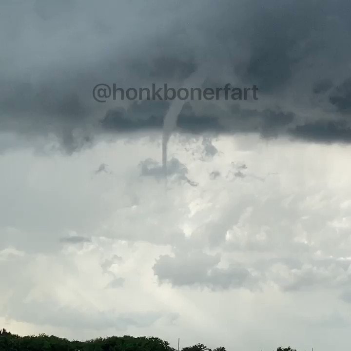
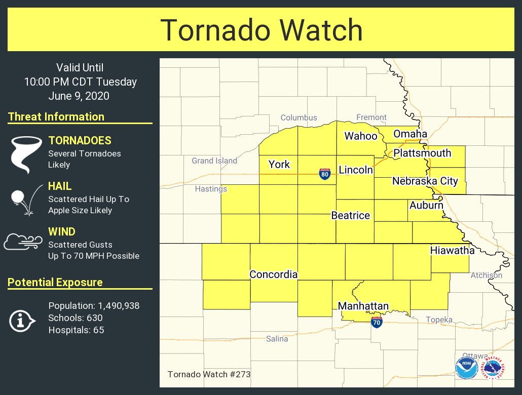
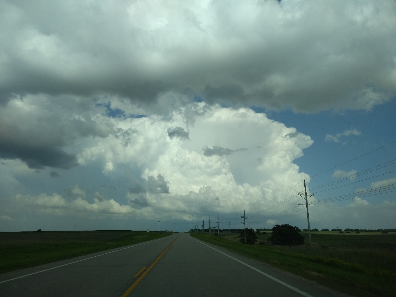
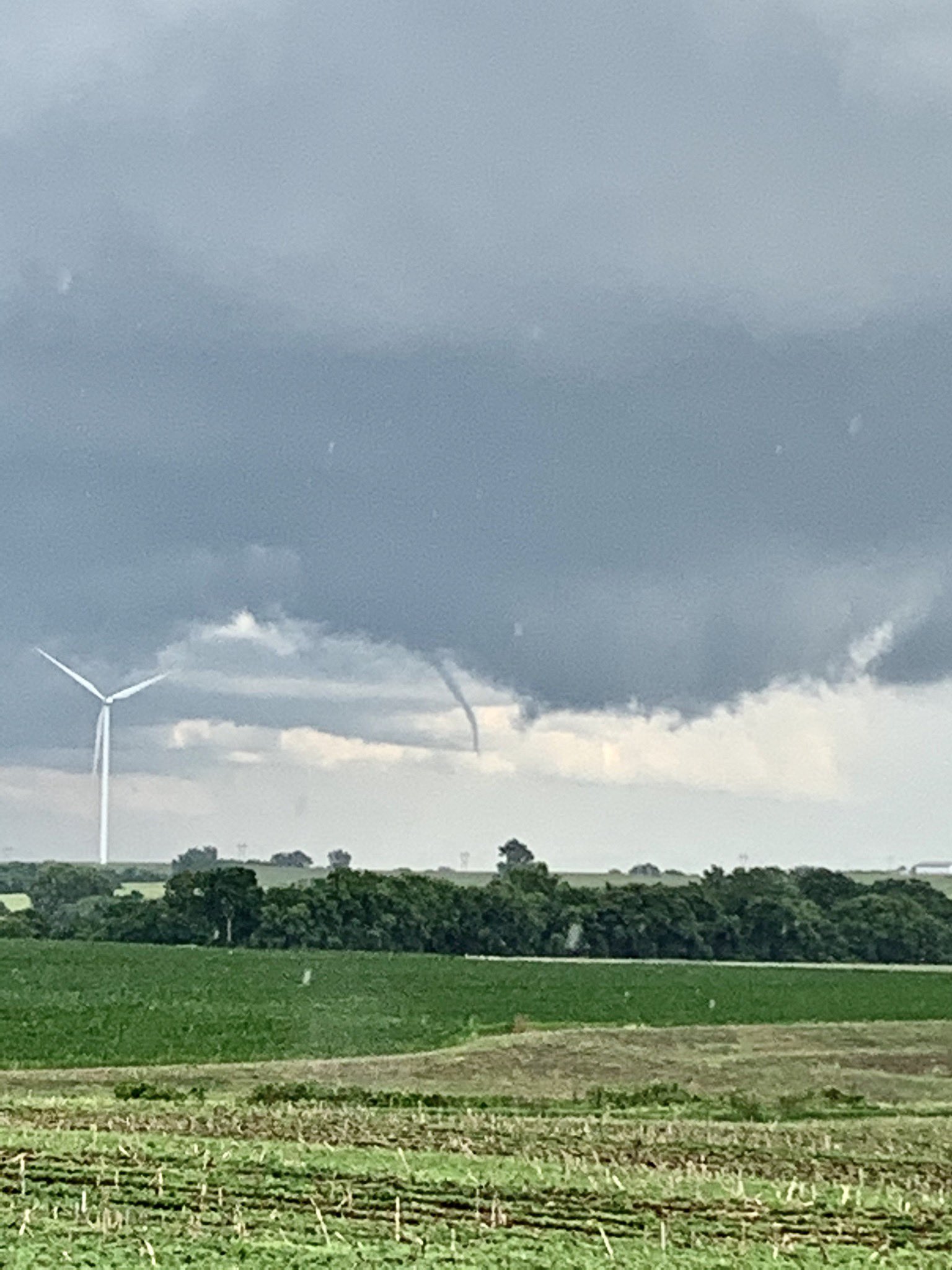
EVENT ARCHIVE / 06-09-2020_ks_ne
Avatar
Cameron (Fortson, GA) 08-Jun-20 05:49 PM
Surface Low FTW
Avatar
Jacob Punch (Kansas City) 08-Jun-20 07:15 PM
tomorrow gonna be huge
take that to the bank
Avatar
Randy Cooper(St Joseph, MO) 08-Jun-20 11:13 PM
Will be interesting to see what effect Cristobal will have on the system over here(if any)
Avatar
Jacob Punch (Kansas City) 09-Jun-20 01:21 AM
Y’all will see today’s event outplay every other event this week
Avatar
Payton (Lawrence, KS) 09-Jun-20 01:30 AM
Lies we tell ourselves
Avatar
Cameron (Fortson, GA) 09-Jun-20 01:56 AM
CONVECTION IS EXPECTED TO INITIATE BY 19-20Z THEN SPREAD EAST ALONG THE KS/NE BORDER REGION AS STRONG LARGE-SCALE FORCING FOR ASCENT SPREADS TOWARD THE MO VALLEY. NAM FORECAST SOUNDINGS STRONGLY FAVOR SUPERCELLS WITH WIND PROFILES SUPPORTIVE OF TORNADOES. SOME CONSIDERATION WAS GIVEN TO INCREASING TORNADO PROBS ALONG THE NE/KS BORDER WHERE FAVORABLY BACKED LOW-LEVEL INFLOW WILL LIKELY ENHANCE SHEAR. OTHERWISE, VERY LARGE HAIL AND DAMAGING WINDS APPEAR POSSIBLE WITH THESE AFTERNOON STORMS.
ohshit 5
Avatar
Cameron (Fortson, GA) 09-Jun-20 02:08 AM
LOCK IT IN
Avatar
Jacob Punch (Kansas City) 09-Jun-20 02:24 AM
UGH WHAT DO I DO
frat party or chase
Avatar
Josh Zitko(Cimarron, NM/STL, MO) 09-Jun-20 02:26 AM
Well, in my experience, frat parties are late, so chase, then party
Avatar
Jacob Punch (Kansas City) 09-Jun-20 02:27 AM
Ya but it’s in manhattan
Avatar
Josh Zitko(Cimarron, NM/STL, MO) 09-Jun-20 02:31 AM
🤔
Avatar
Randy Cooper(St Joseph, MO) 09-Jun-20 06:38 AM
🤩 I’m actually legit excited about today
Avatar
Mark Jack (Westmoreland, KS) 09-Jun-20 07:21 AM
Came into work early so I can get off early and head north. Haha
Avatar
Randy Cooper(St Joseph, MO) 09-Jun-20 07:54 AM
Same, except west
Avatar
Payton (Lawrence, KS) 09-Jun-20 08:56 AM
I think I might target Beatrice. Not sure if it's too far south though
Avatar
Randy Cooper(St Joseph, MO) 09-Jun-20 09:04 AM
I’m thinking Belleville KS
Avatar
Payton (Lawrence, KS) 09-Jun-20 09:04 AM
For initiation?
I was looking at later hours so I should proably look closer to there
Avatar
Ed Tierney (Des Plaines, IL) 09-Jun-20 09:05 AM
ENH added to KS/NE with a 10% unhatched tor
Avatar
Payton (Lawrence, KS) 09-Jun-20 09:37 AM
How is cell service up in this area? I've got Verizon.
Avatar
Randy Cooper(St Joseph, MO) 09-Jun-20 09:39 AM
Should be fine
Couple holes in extreme northeast ks
Avatar
Payton (Lawrence, KS) 09-Jun-20 09:41 AM
When I was up near the Marysville and Seneca area, I had issues. Those must be the holes then
Avatar
Grant Leighty (Kansas City, MO) 09-Jun-20 09:46 AM
I guess today is a day to go chasing. Looks like it will be one of the better setups this year.
Avatar
Payton (Lawrence, KS) 09-Jun-20 10:04 AM
@Jacob Punch (Kansas City) you chase.
I think I'll start out near Washington, KS and see what happens from there
Avatar
Grant Leighty (Kansas City, MO) 09-Jun-20 10:06 AM
That’s what I was thinking, between Washington and Marysville, KS.
Avatar
Randy Cooper(St Joseph, MO) 09-Jun-20 10:20 AM
Marysville to Belleville to start for me (edited)
Avatar
Jake Wallentine (Wichita, KS) 09-Jun-20 10:52 AM
Belleville would be a good start.
Avatar
Randy Cooper(St Joseph, MO) 09-Jun-20 11:02 AM
Just hope I make it in time. Waiting for a buddy to meet me here. Hopefully be outta here and jetting west on 36 by noon-12:30
Avatar
Payton (Lawrence, KS) 09-Jun-20 11:03 AM
Same. I got my dad to come along but he's trying to finish stuff at home right now.
Avatar
Royce Sheibal (Papillion,NE) 09-Jun-20 11:10 AM
a separate channel just for my triple point I'm so jelly
maryville is good, btu i'd prefer to stay on the nebraska side between beatrice and deshler
HRRR has multiple high UH cells in the 0-3KM range from SC NEB early around 3pm into the lincoln area by 6pm
SRH maximizes as we get towards 6-7pm, best change for tornadoes IMO, could be very messy as PWET is very high, expect HP monsters just like yesterday
Avatar
Payton (Lawrence, KS) 09-Jun-20 11:19 AM
Isn't initiation farther SW than beatrice? I think that's why I like the KS side to start with
Avatar
Jake Wallentine (Wichita, KS) 09-Jun-20 11:33 AM
HRRR showing a couple earlier cells firing closer to I80....then the rest of the show fires back SW on the KS side likely.
Avatar
Royce Sheibal (Papillion,NE) 09-Jun-20 11:33 AM
If u believe HRRR, initiation will occur about 75mi west of Beatrice
In this triple point setup I expect some early pops near the TP. Then a ripcord working ESE
Cell motion rapid to the NNE with right Turner's bring the target cells once they deviate
Avatar
Royce Sheibal (Papillion,NE) 09-Jun-20 12:11 PM
7pm beatrice, ne
Avatar
Jacob Punch (Kansas City) 09-Jun-20 12:23 PM
going
Avatar
Randy Cooper(St Joseph, MO) 09-Jun-20 12:35 PM
I’m heading out within the hour
Avatar
Mark Jack (Westmoreland, KS) 09-Jun-20 12:39 PM
I'll be up in Marysville around 4 ish.
Avatar
Jake Wallentine (Wichita, KS) 09-Jun-20 12:55 PM
The post frontal winds will be insane on the backside of this system.
Avatar
Jacob Punch (Kansas City) 09-Jun-20 12:57 PM
should I chase?
Avatar
Randy Cooper(St Joseph, MO) 09-Jun-20 01:00 PM
If you have to ask...
Avatar
Payton (Lawrence, KS) 09-Jun-20 01:01 PM
It's 10% tor
What do you think
Avatar
Josh Zitko(Cimarron, NM/STL, MO) 09-Jun-20 01:01 PM
Avatar
Payton (Lawrence, KS) 09-Jun-20 01:34 PM
Looks like clouds are starting to come in. Hopefully that won't be an issue
Avatar
Jake Wallentine (Wichita, KS) 09-Jun-20 01:35 PM
Where at? I see fair weather cumulus on the warm side and overcast on the cool side. Nothing upper level to cause any issues yet.
Avatar
Payton (Lawrence, KS) 09-Jun-20 01:35 PM
The fair weather cumulus, just wanting there.to be as much heating as it can get
Avatar
Jake Wallentine (Wichita, KS) 09-Jun-20 01:37 PM
Gotcha. Ya, i doubt that hinders too much of the insolation.
Avatar
Royce Sheibal (Papillion,NE) 09-Jun-20 01:42 PM
TD gaps are near 20F as highs get near 90/70
we need some clouds to keep from blowing our gaps
i'd like to see 85/70 ideally, keep LCL's around 1000
Avatar
Royce Sheibal (Papillion,NE) 09-Jun-20 02:07 PM
it's 93/71 here in papillion, well NE of the area of interest, so it's juicy out there for sure
Avatar
Randy Cooper(St Joseph, MO) 09-Jun-20 02:10 PM
I’m westbound on hwy 36 near Hiawatha
Avatar
Royce Sheibal (Papillion,NE) 09-Jun-20 02:12 PM
maryville, belleville, hebron, beatrice would be my target area, i'm going for the N side
Avatar
Payton (Lawrence, KS) 09-Jun-20 02:13 PM
En route to Belleville, still an hour and a half out.. may change from there
Avatar
Jacob Punch (Kansas City) 09-Jun-20 02:28 PM
Haven’t left my house yet
Avatar
Payton (Lawrence, KS) 09-Jun-20 02:37 PM
Not gonna go out?
Avatar
Royce Sheibal (Papillion,NE) 09-Jun-20 02:40 PM
quite the frenetic forecast, feels like either a big day, or a bust, not sure of what failure modes are right now
we could get too much crapvection early, taht would hurt our prime time 6-8pm zone. or we could get an early bow-echo that just crushes the warm sector
Avatar
Jacob Punch (Kansas City) 09-Jun-20 02:41 PM
I’ll probably be leaving later. No point in leaving yet. No point in going all the way to ‘Maryville
Avatar
Royce Sheibal (Papillion,NE) 09-Jun-20 02:42 PM
there will be good tor potential all the way to KC, depending on how this triple point zippers
Avatar
Royce Sheibal (Papillion,NE) 09-Jun-20 02:55 PM
lightnign just S of i-80 west of lincoln
cells forming are fairly tall, skinny, but appear to not be multi-cellular, could be a mini-supercell storm mode in that region
they appear to be elevated, but as they zipper south i expect surface based storms will form
Avatar
Jacob Punch (Kansas City) 09-Jun-20 03:00 PM
I’m just gonna wait. No point in going anywhere yet. I believe that the 10% will actually get moved further into NW MO and NE KS.
Avatar
Royce Sheibal (Papillion,NE) 09-Jun-20 03:01 PM
current storms still firign behidn the front. we got a long way to go
Avatar
Jacob Punch (Kansas City) 09-Jun-20 03:02 PM
exactly
Avatar
Pat Kepka (Russell Co. KS) 09-Jun-20 03:06 PM
Tor watch by 2:30 pm likely (edited)
Avatar
Royce Sheibal (Papillion,NE) 09-Jun-20 03:17 PM
that's some blue, boys. wedges
Avatar
Jacob Melton (Owosso, MI) 09-Jun-20 03:35 PM
A tornado watch has been issued for parts of Iowa, Kansas and Nebraska until 10 PM CDT
Avatar
Cameron (Fortson, GA) 09-Jun-20 03:42 PM
80/20 bois
Avatar
Jacob Punch (Kansas City) 09-Jun-20 03:43 PM
what a disgrace to a watch
Avatar
Randy Cooper(St Joseph, MO) 09-Jun-20 03:53 PM
You’re only mad you’re not out here 😂
this 3
Avatar
Jacob Punch (Kansas City) 09-Jun-20 03:54 PM
Oh i will be out soon!
Storms fear me so much, whenever I go out they hide
this 1
Avatar
Cameron (Fortson, GA) 09-Jun-20 04:31 PM
Brad's storm looks nice
Avatar
Payton (Lawrence, KS) 09-Jun-20 04:35 PM
Where's he at?
Avatar
Cameron (Fortson, GA) 09-Jun-20 04:41 PM
Just north of Hebron
Avatar
Cameron (Fortson, GA) 09-Jun-20 04:57 PM
Looks like cell is now splitting
Avatar
Payton (Lawrence, KS) 09-Jun-20 05:04 PM
Just as I got on it
Avatar
Cameron (Fortson, GA) 09-Jun-20 05:09 PM
Well I mean it is a right split, I'm gonna give it a chance and see if it can deviate storm motion and ingest some more SRH and get going
also wondering if it's trying to ride that boundary (edited)
Avatar
Payton (Lawrence, KS) 09-Jun-20 05:17 PM
I'm not seeing anything promising yet
Avatar
Cameron (Fortson, GA) 09-Jun-20 05:35 PM
Some promising cells in KS, watching Eric Kelly on one, looks to have a good inflow tail going for it
Avatar
Royce Sheibal (Papillion,NE) 09-Jun-20 05:39 PM
Nebraska storms are a trap right now. KS cells are the hope
The stuff west of Lincoln is all behind the front
Avatar
Payton (Lawrence, KS) 09-Jun-20 05:41 PM
Everything is west of Lincoln
Avatar
Royce Sheibal (Papillion,NE) 09-Jun-20 06:06 PM
KS line is going,. Slowly. Finally
Avatar
Payton (Lawrence, KS) 09-Jun-20 06:07 PM
Can they stop going north
That would be nice
Avatar
Royce Sheibal (Papillion,NE) 09-Jun-20 06:15 PM
Where is Duda? I'm calling a bust
It's not official until he is summoned and trolls us
Avatar
Cameron (Fortson, GA) 09-Jun-20 06:30 PM
The cell i'm watching went SVR, nice
Avatar
Payton (Lawrence, KS) 09-Jun-20 06:35 PM
Moving towards Maryville now
Avatar
Cameron (Fortson, GA) 09-Jun-20 06:38 PM
Is this cell splitting already
Splitting supercell in northern Pottawattamie county. Right split looks soft. #kswx
Avatar
Royce Sheibal (Papillion,NE) 09-Jun-20 07:08 PM
Tor warm near fairbury
Tor behind the front, what the shit
Avatar
Payton (Lawrence, KS) 09-Jun-20 07:09 PM
And I'm stuck going east to Marysville
Avatar
Jacob Melton (Owosso, MI) 09-Jun-20 07:09 PM
Avatar
Royce Sheibal (Papillion,NE) 09-Jun-20 07:10 PM
Jefferson county, always. Most tors per square mile in the country
Avatar
Cameron (Fortson, GA) 09-Jun-20 07:10 PM
I love how the ass cell
TOR'd
#2020ing
Yao 2
Avatar
Payton (Lawrence, KS) 09-Jun-20 07:12 PM
I think im solo chasing from here on out
Avatar
Cameron (Fortson, GA) 09-Jun-20 07:12 PM
And the right split is now gonna merge with another cell
Avatar
Payton (Lawrence, KS) 09-Jun-20 07:12 PM
Or driving
Avatar
Cameron (Fortson, GA) 09-Jun-20 07:18 PM
Bryce Kintigh: Eating Hardee's 400 people: Interesting
Evnt 2 miles NNW of VERMILLION, KS @ 23:23 UTC Funnel>-Large funnel now need tornado warning.
Just caught this funnel cloud just N of Vermilion, KS. @NWSTopeka #KSwx
Avatar
Randy Cooper(St Joseph, MO) 09-Jun-20 07:36 PM
East 5
I got it!
Avatar
Josh Zitko(Cimarron, NM/STL, MO) 09-Jun-20 07:37 PM
Nice!
Avatar
Royce Sheibal (Papillion,NE) 09-Jun-20 07:37 PM
Confirmed tor cell in Jefferson county about to merge with cell. Could get interesting
Avatar
Jacob Punch (Kansas City) 09-Jun-20 08:27 PM
that was the storm I’ve been watching
I directed my friend to that storm
Avatar
Glen Heinz (Greenville, SC) 09-Jun-20 08:38 PM
#tornado #funnel north Vermillion Kansas USA! @weatherchannel #frenchstormhunt #tornante https://t.co/F0Yb5BdEJE
Avatar
Adam Reagan (Norman, OK) 09-Jun-20 08:41 PM
Love the Twitter handle. 😂
Avatar
Glen Heinz (Greenville, SC) 09-Jun-20 08:44 PM
me too...lol.
Avatar
Royce Sheibal (Papillion,NE) 09-Jun-20 09:44 PM
Just got home in Omaha. We just got curbstomped with 60mph winds for like 45 mins all while it's pouring blinding rain. Way to core punch ourselves.
I was outside my car for maybe 10 seconds and I'm soaked
Avatar
Glen Heinz (Greenville, SC) 09-Jun-20 09:50 PM
dang, sounds like a tropical system.
Avatar
Royce Sheibal (Papillion,NE) 09-Jun-20 10:01 PM
Just lost power for a sec. Winds forecast to be up to 65 mph overnight. With rain. It's like a fucking hurricane
Avatar
cricketkepler 09-Jun-20 10:14 PM
@Payton (Lawrence, KS) y?
Avatar
Payton (Lawrence, KS) 09-Jun-20 10:38 PM
I prefer being the one making the decisions and Everytime I've been with someone, they've wanted to head back when we still had chances. Things like that
Avatar
Josh Zitko(Cimarron, NM/STL, MO) 09-Jun-20 10:39 PM
I get what you mean
Avatar
Josh Zitko(Cimarron, NM/STL, MO) 09-Jun-20 10:50 PM
I personally would love someone else with me actually knowledgeable about storms. (edited)
Avatar
Payton (Lawrence, KS) 09-Jun-20 10:59 PM
My dad is knowledgeable but with aviation related weather, not so much spotting
Avatar
Josh Zitko(Cimarron, NM/STL, MO) 09-Jun-20 11:01 PM
@Payton (Lawrence, KS) also, a partner that doesn't bail lol
I'm definitely of the "you gotta stick around if there's an opportunity" mind (edited)
And even if not, you can post up and watch it ride into the distance for a sweet timelapse (edited)
Exported 146 message(s)