Guild icon
Stormtrack
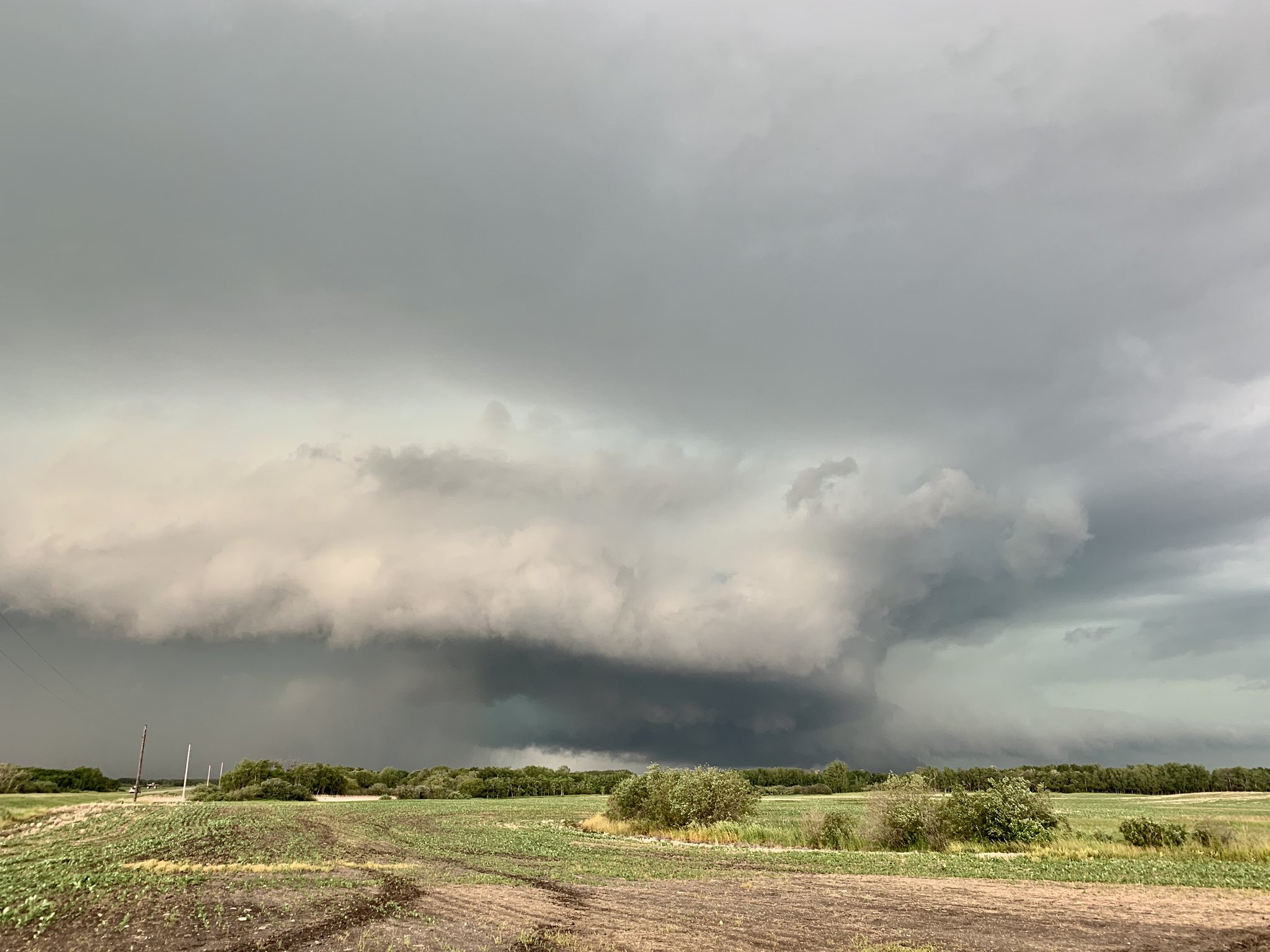
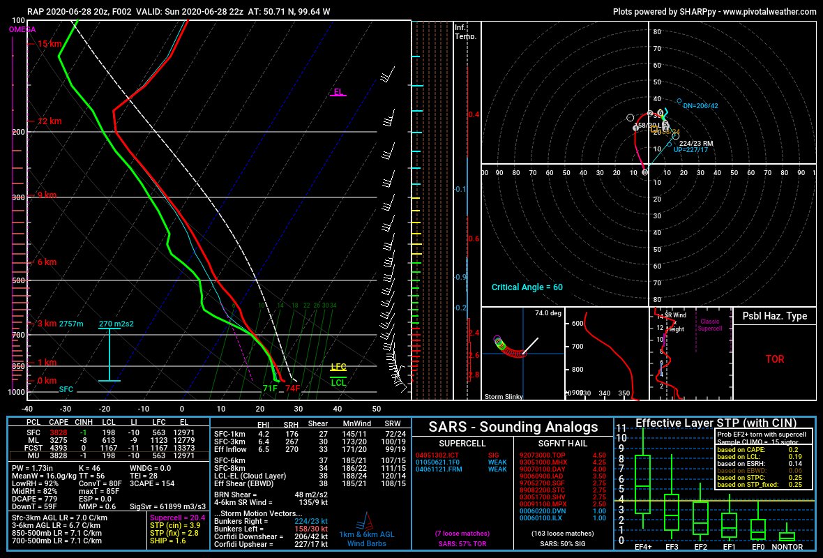
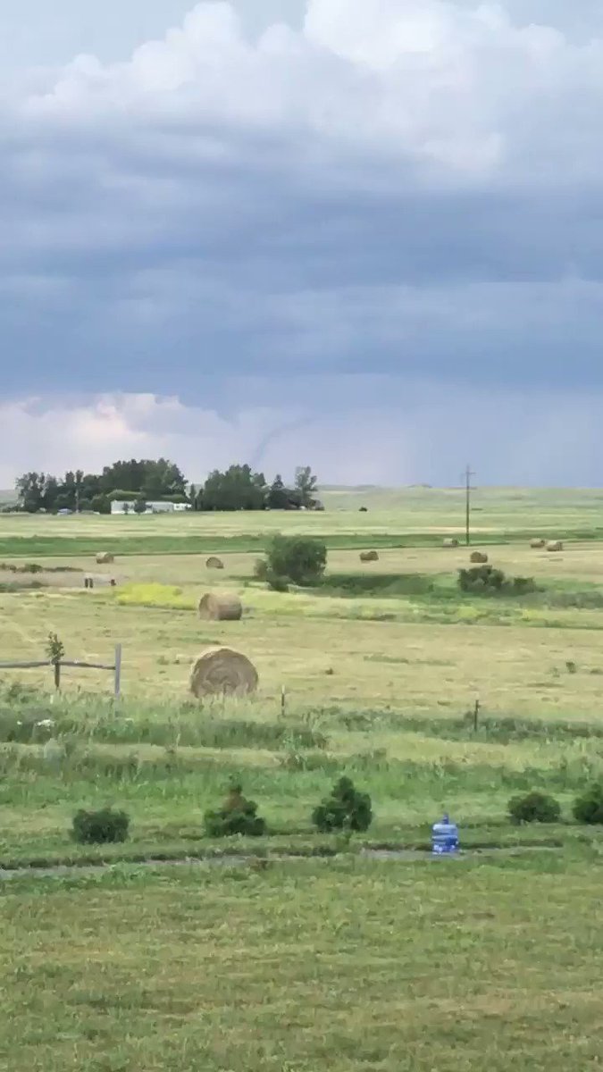
EVENT ARCHIVE / 06-28-2020_mn_ia
Avatar
Josh Zitko(Cimarron, NM/STL, MO) 27-Jun-20 02:51 PM
...IA/MN vicinity... A Slight risk has been introduced across northwest IA into southern MN. Most guidance shows an embedded shortwave impulse or possible MCV migrating across the area on Sunday. This appears plausible given expected convection over the central Plains in the Day 1 period. A weak warm front will also be draped across the region from near the Sioux Falls area southeastward toward the Quad Cities IA vicinity. Strong heating and upper 60s F surface dewpoints will result in strong destabilization and any storms that develop will have the potential for damaging wind gusts and hail. Additionally, given the warm front draped across the area, a few tornadoes are also possible due to enhanced SRH and mean mixing ratios near 16 g/kg. Some guidance suggests capping could limit coverage of storms, but most guidance does develop at least isolated storms. Given the thermodynamic and kinematic parameter space supportive of severe supercells/bowing segments, an upgrade to Slight appears warranted.
Avatar
Joey Prom (Lafayette, IN) 27-Jun-20 04:17 PM
Fingers crossed that the forcast holds up or improves. I am so tired of busted forcasts
Avatar
Joey Prom (Lafayette, IN) 27-Jun-20 04:27 PM
I am concerned that HRRR continues to fail to show initiation
this 1
Avatar
Josh Zitko(Cimarron, NM/STL, MO) 27-Jun-20 04:29 PM
I'm a little concerned too. But, pretty much all other models are showing initiation.
Avatar
Joey Prom (Lafayette, IN) 27-Jun-20 04:30 PM
I guess its a question for Jeff Duda. What does HRRR look for for initiation
Avatar
Cameron (Fortson, GA) 27-Jun-20 04:30 PM
I likey
HRRR 18Z shows atleast 1-2 supercells popping off in Iowa and moving eastward (edited)
Avatar
Josh Zitko(Cimarron, NM/STL, MO) 27-Jun-20 04:35 PM
If I was teleporting myself somewhere right now to start tomorrow, it'd be central Iowa
Avatar
Cameron (Fortson, GA) 27-Jun-20 04:36 PM
Shortwave go brrrr (edited)
Watching June 30th too
Avatar
Joey Prom (Lafayette, IN) 27-Jun-20 04:39 PM
HRRR cells it shows are not over the same area is the maximized STP/SCP. Those are part of something else I think, the initial morning convection, which the NAM completely kills off.
Avatar
Cameron (Fortson, GA) 27-Jun-20 04:40 PM
Me and my homies hate STP (edited)
Avatar
Joey Prom (Lafayette, IN) 27-Jun-20 04:42 PM
I sent a question to Jeff Duda about the HRRR model. We shall see if he responds
Avatar
Cameron (Fortson, GA) 27-Jun-20 04:42 PM
Still is convectiving within the Warm-sector with decent instability and backing surface winds
Regardless of highest STP values or not
Avatar
Joey Prom (Lafayette, IN) 27-Jun-20 04:43 PM
That area is also much farther away than I would like, given I have a morning meeting back in the Twin Cities on MOnday at 8:15
I also really wish the RAP went out farther, like the NAM does, Instead of mostly just day of.
Avatar
Cameron (Fortson, GA) 27-Jun-20 04:43 PM
Yeah but HRRR needs to get rid of morning convection and get something initiating near that WF in the warm-sector
15Z RAP runs to tom
Avatar
Joey Prom (Lafayette, IN) 27-Jun-20 04:44 PM
yea, but not 18z
Avatar
Cameron (Fortson, GA) 27-Jun-20 04:45 PM
I think we can play it by ear and see what the Suite says tonight
Also I'm not well traversed in the midwest anyway but I know Iowa likes to pull quirky things
Avatar
Josh Zitko(Cimarron, NM/STL, MO) 27-Jun-20 04:48 PM
Idk about you Joey but this would probably be a tonight call for me, and it's a longer drive for you
Avatar
Mike Thornton (Norman, OK) 27-Jun-20 05:12 PM
Lol. Significant Tornado Parameter.... (edited)
Avatar
Josh Zitko(Cimarron, NM/STL, MO) 27-Jun-20 05:13 PM
I don't use it really. Supercell Composite I put a little bit of stock in, but only to get a general idea of things, since it's subject to being misleading, and thrown off by one component
Avatar
Mike Thornton (Norman, OK) 27-Jun-20 05:13 PM
I will leave my comment at what I wrote above.
Avatar
Joey Prom (Lafayette, IN) 27-Jun-20 05:23 PM
I am planning to leave at 8am tomorrow. Drive down I35. That lets me play either NAM's idea (west towards Omaha) or RAP/HRRR (east towards Dubuque)
Avatar
Josh Zitko(Cimarron, NM/STL, MO) 27-Jun-20 05:24 PM
I was honestly thinking about leaving tonight, leaving the option to sleep in and get some rest before the chase
Avatar
Josh Zitko(Cimarron, NM/STL, MO) 27-Jun-20 05:32 PM
We'll see what 00z runs show
Avatar
Joey Prom (Lafayette, IN) 27-Jun-20 07:04 PM
I have 5.5 hr drive to Omaha
Avatar
Josh Zitko(Cimarron, NM/STL, MO) 27-Jun-20 07:06 PM
Nebraska?
Avatar
Joey Prom (Lafayette, IN) 27-Jun-20 07:06 PM
If anyone is interested in caravaning tomorrow I am all ears. Please reach out to me in a PM. My usual chase partner balked at leaving by 8am. IMO this is a serious setup and I want to give it the full time it deserves
I wouldnt take it to NE, but if needed
Avatar
Josh Zitko(Cimarron, NM/STL, MO) 27-Jun-20 07:06 PM
Mmm
5.5 hours gets me to around Des Moines
Avatar
Joey Prom (Lafayette, IN) 27-Jun-20 07:07 PM
I am planning to drive down 35 to des moines, JIC the eastern thing the HRRR was hinting at happens. Also its the fastest route to Omaha, 35 - 88
Avatar
Josh Zitko(Cimarron, NM/STL, MO) 27-Jun-20 07:08 PM
Whether I decide to go tonight and sleep somewhere, or go tomorrow sorta changes plans. Not sure yet.
Find a truck stop somewhere maybe
Avatar
TJ (Houston/Galveston TX) 27-Jun-20 09:09 PM
Looks like a home play Sunday IOWA . Back in the home state looking for a good chase. So far the NAM isn't lining up with the SPC.
Avatar
Cameron (Fortson, GA) 27-Jun-20 09:11 PM
Quirky NAM cherrypicking
Avatar
Josh Zitko(Cimarron, NM/STL, MO) 27-Jun-20 09:13 PM
Talk about veerback (edited)
this 2
Avatar
Cameron (Fortson, GA) 27-Jun-20 09:13 PM
I just don't want morning convection stablizing it
because HRRR drapes some spicy boundaries
0Z HRRR coming in
Avatar
Joey Prom (Lafayette, IN) 27-Jun-20 09:37 PM
HRRR wants to kill me now
Avatar
Josh Zitko(Cimarron, NM/STL, MO) 27-Jun-20 09:38 PM
HRRR is still not showing initiation....
Avatar
Joey Prom (Lafayette, IN) 27-Jun-20 09:38 PM
I really hope HRRR is wrong
Waiting for 0z NAM
Avatar
Mike Thornton (Norman, OK) 27-Jun-20 09:47 PM
It's one model run. Look at consistency before you completely call off tomorrow.
Avatar
Josh Zitko(Cimarron, NM/STL, MO) 27-Jun-20 09:48 PM
That's the thing, everything else has been fairly consistently firing cells, HRW CAMs and NAM3k, and HRRR has been consistently not firing anything at all afternoon.
Avatar
Joey Prom (Lafayette, IN) 27-Jun-20 09:49 PM
NAM has been showing this setup for 3 days.
Avatar
Mike Thornton (Norman, OK) 27-Jun-20 09:50 PM
@Joey Prom (Lafayette, IN) well, it goes out the 5-day so I hope it would be showing it for three days.
I know what you meant ^
Avatar
Joey Prom (Lafayette, IN) 27-Jun-20 09:50 PM
I guess I am trying to say I want to trust the NAM on this one, as it has been very consistant.
Avatar
Mike Thornton (Norman, OK) 27-Jun-20 09:50 PM
I wouldn't really take anything at face value with the HRRR until around 2am when it begins to come into range hourly for the afternoon.
this 3
@Joey Prom (Lafayette, IN) yes. I knew what you meant
Avatar
Joey Prom (Lafayette, IN) 27-Jun-20 09:51 PM
There is a lot of veer-back with the soundings tho. I am guessing that that is due to there only being a small 500 mb shortwave, no broad deep flow
But the moisture is already there from the previous systems
Just need a little something to get things going
Thank you for your voice of reason @Mike Thornton (Norman, OK)
I will be sound asleap at 2am
Avatar
Josh Zitko(Cimarron, NM/STL, MO) 27-Jun-20 09:53 PM
Indeed, thank you for the voice of reason haha
Still. If we drive out tonight, I gotta make the call tonight, tomorrow, it'd be a longer day full of driving, but I could potentially be better informed to call yes or no?
Avatar
Mike Thornton (Norman, OK) 27-Jun-20 09:54 PM
Not really a voice of reason. It's just the truth after having chased for 5 years.
Avatar
Joey Prom (Lafayette, IN) 27-Jun-20 09:54 PM
You could always just drive partway (edited)
this 2
Avatar
Joey Prom (Lafayette, IN) 27-Jun-20 10:02 PM
Ok, this is how I know 2020 is nuts. This latest run, HRRR goes squall line, NAM goes rogue Supercell tracking all the way across IA. nuts I say!
IOWA 5
Avatar
Josh Zitko(Cimarron, NM/STL, MO) 27-Jun-20 10:09 PM
Dude, all of these runs have been weird
Avatar
Joey Prom (Lafayette, IN) 27-Jun-20 10:12 PM
This is a chase where I will have to trust the surface obs and the spc
NAM is the nuclear model for this setup
Avatar
Cameron (Fortson, GA) 27-Jun-20 10:19 PM
I'ma look at convective trends and OBS at this point
This is a wild card
Avatar
Josh Zitko(Cimarron, NM/STL, MO) 28-Jun-20 12:39 AM
We're on the road, hoping to knock out a few more hours.
Avatar
Josh Zitko(Cimarron, NM/STL, MO) 28-Jun-20 02:09 AM
The RAP is forecasting MLCAPE to peak above 5500 J/kg in eastern Nebraska with a tight instability gradient across western Iowa. Low-level convergence is forecast to become maximized in far northeast Nebraska by 00Z/Monday which will help with convective initiation. Thunderstorms are expected to develop during the early evening and move eastward across central and northern Iowa. In addition to the extreme instability, RAP forecast soundings in western Iowa at 00Z have 0-3 km shear near 30 kt with some directional shear in the low-levels. This environment should be favorable for severe storms as cell coverage increases during the early to mid evening. Wind damage, isolated large hail, and perhaps a tornado or two will be possible with supercells and organized multicells.
Avatar
Josh Zitko(Cimarron, NM/STL, MO) 28-Jun-20 07:26 AM
Models showing later initiation, probably because of morning storms sticking around
NAM also showing only very briefly cellular in the most recent run
Not a fan of this morning convection
Avatar
Joey Prom (Lafayette, IN) 28-Jun-20 10:32 AM
Now it looks like I will be able to chase out of my back yard
Avatar
Josh Zitko(Cimarron, NM/STL, MO) 28-Jun-20 10:35 AM
Gonna hit Des Moines in the next half hour or so. Probably find a coffee shop or something with WiFi and watch surface obs
Avatar
Joey Prom (Lafayette, IN) 28-Jun-20 10:53 AM
Who is ready for some good 'ol Mankato Madness today?
Avatar
TJ (Houston/Galveston TX) 28-Jun-20 12:01 PM
I'm about an hour from Mankato... let's hope the storm isn't nocturnal
Avatar
Joey Prom (Lafayette, IN) 28-Jun-20 12:13 PM
Everyone, prepare to smash those refresh buttons in 15 minutes...
Avatar
Cameron (Fortson, GA) 28-Jun-20 12:33 PM
AS A LOW-LEVEL JET STRENGTHENS, WARM ADVECTION ON THE SOUTHWEST FLANK OF THE MCV (ROOTED IN THE RICHER MOISTURE/STEEPER LAPSE RATES ACROSS EASTERN NE) WILL INCREASE AND BECOME SUPPORTIVE OF THUNDERSTORM INITIATION. DAYTIME HEATING AND BOUNDARY-LAYER DEWPOINTS OF 70-72 F, BENEATH MIDLEVEL LAPSE RATES GREATER THAN 8 C/KM, WILL RESULT IN MLCAPE NEAR 4000 J/KG, WHICH WILL SUPPORT INTENSE UPDRAFTS. A MESOSCALE REGION OF ENHANCED LOW-LEVEL SHEAR/HODOGRAPH CURVATURE AND DEEP-LAYER SHEAR IN THAT ZONE OF WARM ADVECTION WILL INITIALLY FAVOR SUPERCELLS CAPABLE OF PRODUCING VERY LARGE HAIL AND A COUPLE OF TORNADOES. THE THREAT FOR OCCASIONAL LARGE HAIL AND DAMAGING WINDS WILL PERSIST OVERNIGHT AS CONVECTION GROWS UPSCALE INTO AN MCS.
Avatar
Joey Prom (Lafayette, IN) 28-Jun-20 12:46 PM
Welp, heading to Iowa after all
Avatar
Cameron (Fortson, GA) 28-Jun-20 01:21 PM
Avatar
Josh Zitko(Cimarron, NM/STL, MO) 28-Jun-20 01:22 PM
Uhhh why am I not seeing that on radarscope
@Cameron (Fortson, GA) what tag is that?
Avatar
Cameron (Fortson, GA) 28-Jun-20 01:24 PM
Law Enforcement
Reported 2 funnels
Avatar
Josh Zitko(Cimarron, NM/STL, MO) 28-Jun-20 01:24 PM
At once?
Dammit radarscope
If radaromega can get all the reports that gr2a can, I might switch
Avatar
Cameron (Fortson, GA) 28-Jun-20 01:27 PM
Avatar
Josh Zitko(Cimarron, NM/STL, MO) 28-Jun-20 01:37 PM
Approaching the cell. (edited)
Avatar
TJ (Houston/Galveston TX) 28-Jun-20 02:27 PM
Storm died, waiting for next development. I'm the little dot up north (edited)
Avatar
Josh Zitko(Cimarron, NM/STL, MO) 28-Jun-20 02:35 PM
@TJ (Houston/Galveston TX) Joey and I are meeting up in Mason City, hopefully find a spot with WiFi and do some looking at what's gonna happen later
Avatar
TJ (Houston/Galveston TX) 28-Jun-20 02:50 PM
Yeah, hanging in Algona. Visiting family for the next two weeks, so this is free bonus chase
Avatar
Cameron (Fortson, GA) 28-Jun-20 03:09 PM
Visible imagery confirms ample moisture is in place with substantial CU fields developing. As the cap is completely eroded over the next few hours, subtle lift will cause storms to form from north to south within the surface trough/front. Lapse rates are steep, and will favor rapid development. While SRH is not particularly high, substantial low-level stretching and slow storm motions within the enhanced vertical vorticity zone may allow a broken line of storms to produce tornadoes prior to merging. In addition, large hail is possible with the initial strong cores.
Troll moment when It's in ND
troll 3
Avatar
Jacob Melton (Owosso, MI) 28-Jun-20 03:46 PM
Avatar
TJ (Houston/Galveston TX) 28-Jun-20 03:49 PM
Graphic hasn't loaded yet
Avatar
Jacob Melton (Owosso, MI) 28-Jun-20 03:51 PM
Of course MBX radar is offline troll
Avatar
Tristan White (Hartselle, AL) 28-Jun-20 04:26 PM
not the best time to be offlineoldman troll
Avatar
Cameron (Fortson, GA) 28-Jun-20 04:53 PM
3:36 pm Rivers, MB looking NW #MBStorm #MBweather #ShareYourWeather @environmentca @StormHour @weathernetwork
Avatar
Ed Tierney (Des Plaines, IL) 28-Jun-20 05:08 PM
Rather atypical look to a Canadian hodograph; assuming RAP has handle on frontal zone (which seems likely given N-ly surface flow and unidirectional mid-levels), this profile can encourage much longer-lived, stronger tornadoes than is typical for the area. https://t.co/uzlWnK...
Avatar
Cameron (Fortson, GA) 28-Jun-20 05:09 PM
Des Moines VWP
Avatar
Tristan White (Hartselle, AL) 28-Jun-20 05:10 PM
yee IOWA ohshit
Avatar
Josh Zitko(Cimarron, NM/STL, MO) 28-Jun-20 05:25 PM
NE of SVR warned cell. Multiple wall clouds seen, looked like one feeding off the other's wet RFD
👀 2
Avatar
TJ (Houston/Galveston TX) 28-Jun-20 05:33 PM
Avatar
TJ (Houston/Galveston TX) 28-Jun-20 07:05 PM
What happened to the IOWA storms? The NAM keeps changing every run (edited)
Avatar
TJ (Houston/Galveston TX) 28-Jun-20 07:47 PM
A few clouds popping east of Sioux City
Avatar
Cameron (Fortson, GA) 28-Jun-20 07:56 PM
Storms attempting to go up in northwest Iowa. No clue what's gonna happen but the sunset tonight should be 🔥 #IAwx
Avatar
Cameron (Fortson, GA) 28-Jun-20 08:06 PM
Is it happening
Avatar
TJ (Houston/Galveston TX) 28-Jun-20 08:12 PM
Great! About time.
Avatar
Cameron (Fortson, GA) 28-Jun-20 08:44 PM
Lastchance.exe
Avatar
Cameron (Fortson, GA) 28-Jun-20 09:04 PM
Best attempts thus far tonight
Avatar
TJ (Houston/Galveston TX) 28-Jun-20 09:05 PM
# nocturnal IOWA
Avatar
Cameron (Fortson, GA) 28-Jun-20 09:05 PM
BUST 6
Avatar
Ed Tierney (Des Plaines, IL) 28-Jun-20 09:06 PM
RIP IOWA
this 6
Avatar
Cameron (Fortson, GA) 28-Jun-20 09:07 PM
These cells are actually going off now
2% IA troll please
Overshooting top on cell by Decatur, NE! @NWSOmaha #newx
Avatar
Cameron (Fortson, GA) 28-Jun-20 09:19 PM
00Z Omaha
Avatar
TJ (Houston/Galveston TX) 28-Jun-20 09:24 PM
Avatar
Cameron (Fortson, GA) 28-Jun-20 09:52 PM
Avatar
Jacob Melton (Owosso, MI) 28-Jun-20 09:56 PM
Lieowa strikes again I see Yao
Avatar
Cameron (Fortson, GA) 28-Jun-20 10:06 PM
Great radar presnetation though for the night
Avatar
Cameron (Fortson, GA) 28-Jun-20 10:19 PM
Avatar
TJ (Houston/Galveston TX) 28-Jun-20 10:20 PM
The Iowa 5% was the kiss of death... Should have left it at 2% tor
Avatar
Cameron (Fortson, GA) 28-Jun-20 10:20 PM
Now Initiation is ongoing in portions if IA and IA/MN border troll (edited)
Avatar
Josh Zitko(Cimarron, NM/STL, MO) 28-Jun-20 11:08 PM
What a day!
Avatar
Cameron (Fortson, GA) 28-Jun-20 11:09 PM
....of disappointment (edited)
Tom looks interesting
I'll say that
Avatar
Josh Zitko(Cimarron, NM/STL, MO) 28-Jun-20 11:13 PM
Disappointment for you? You weren't out were you?
Avatar
Cameron (Fortson, GA) 28-Jun-20 11:15 PM
Tom looks interesting
We'll see what it does
HRRR dreamland
Avatar
Josh Zitko(Cimarron, NM/STL, MO) 28-Jun-20 11:17 PM
Joey and I had a pretty great day!
Well, speaking for myself, but I think I can speak for him too haha
this 1
Avatar
Cameron (Fortson, GA) 28-Jun-20 11:19 PM
That's good, did you guys catch anything?
Avatar
Josh Zitko(Cimarron, NM/STL, MO) 28-Jun-20 11:22 PM
Pending NWS verification, our first tornados!
Caught what we believe to be the funnels, but couldn't see the ground.
Avatar
Cameron (Fortson, GA) 28-Jun-20 11:22 PM
Epic
Avatar
Josh Zitko(Cimarron, NM/STL, MO) 28-Jun-20 11:22 PM
Stayed on that Southern cell all day following it East.
Avatar
Cameron (Fortson, GA) 28-Jun-20 11:23 PM
Those reports were from you guys on that MN/WI cell then
Friend of mine on it said it may of had weak ground circulation at one point about the time those tornado reports came in so it's possible (edited)
Avatar
Josh Zitko(Cimarron, NM/STL, MO) 28-Jun-20 11:26 PM
Depends on which reports. I had a couple of reports at the start, rotating wall cloud then a violent funnel cloud, curious to see if there was any ground circulation in it
Should have been tornado warned at that point...we watched it come so close to dropping multiple times and NWS did nothing
this 1
Avatar
Cameron (Fortson, GA) 28-Jun-20 11:30 PM
The storm I believe eventually went TORR somewhere down that line
Hence tornado reports
With its final push over Wionia brought a great wallcloud with it
Avatar
Josh Zitko(Cimarron, NM/STL, MO) 29-Jun-20 07:55 AM
Yeah, we were on it pretty much until it crossed the Wisconsin border. Gave us a nice lightning show as it died.
👍 6
👀 1
Avatar
Joey Prom (Lafayette, IN) 29-Jun-20 10:01 AM
I reviewd some footage on youtube, I am not sure we would have been able to see the actual funnel cloud. It was just so hazy. Josh you will have to compare your video with what is on youtube. I really want to say it was my first tornado, but I need to be sure.
Avatar
Josh Zitko(Cimarron, NM/STL, MO) 29-Jun-20 11:29 AM
Definitely. I'm still on the road, haven't been able to do much looking, I guess there's footage of the tornado from closer?
Will have to do some looking and match up timestamps.
Avatar
Josh Zitko(Cimarron, NM/STL, MO) 29-Jun-20 11:47 AM
Depends on whether we count seeing any part of the funnel, since I don't know if I ever personally saw ground circulation, because of our angle. (edited)
Avatar
Joey Prom (Lafayette, IN) 30-Jun-20 09:02 PM
I will count seeing the funnel
Exported 170 message(s)