Guild icon
Stormtrack
EVENT ARCHIVE / hurricane-delta-2020
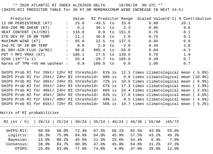
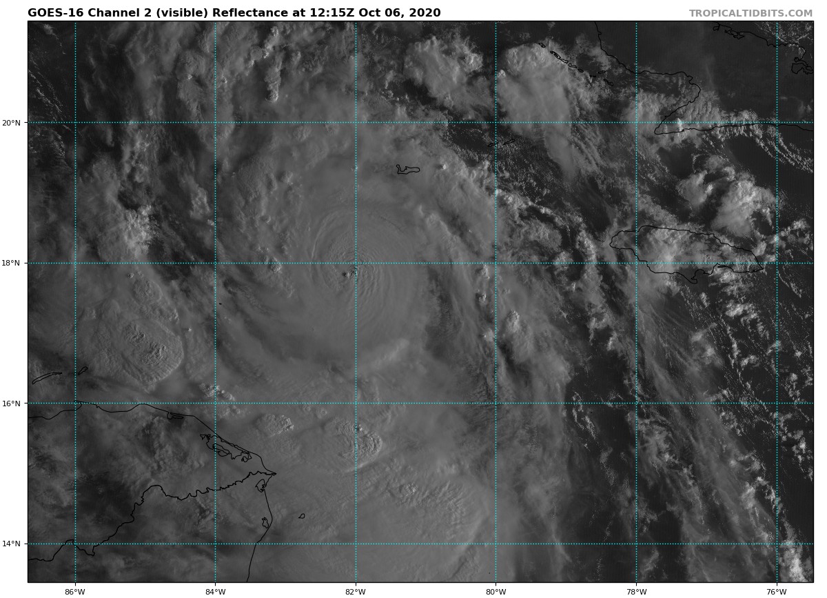
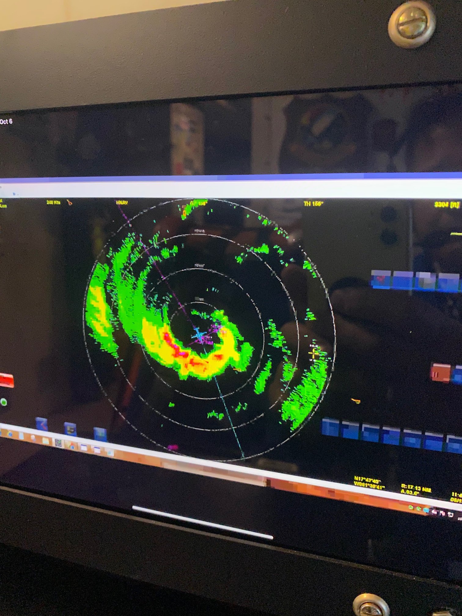
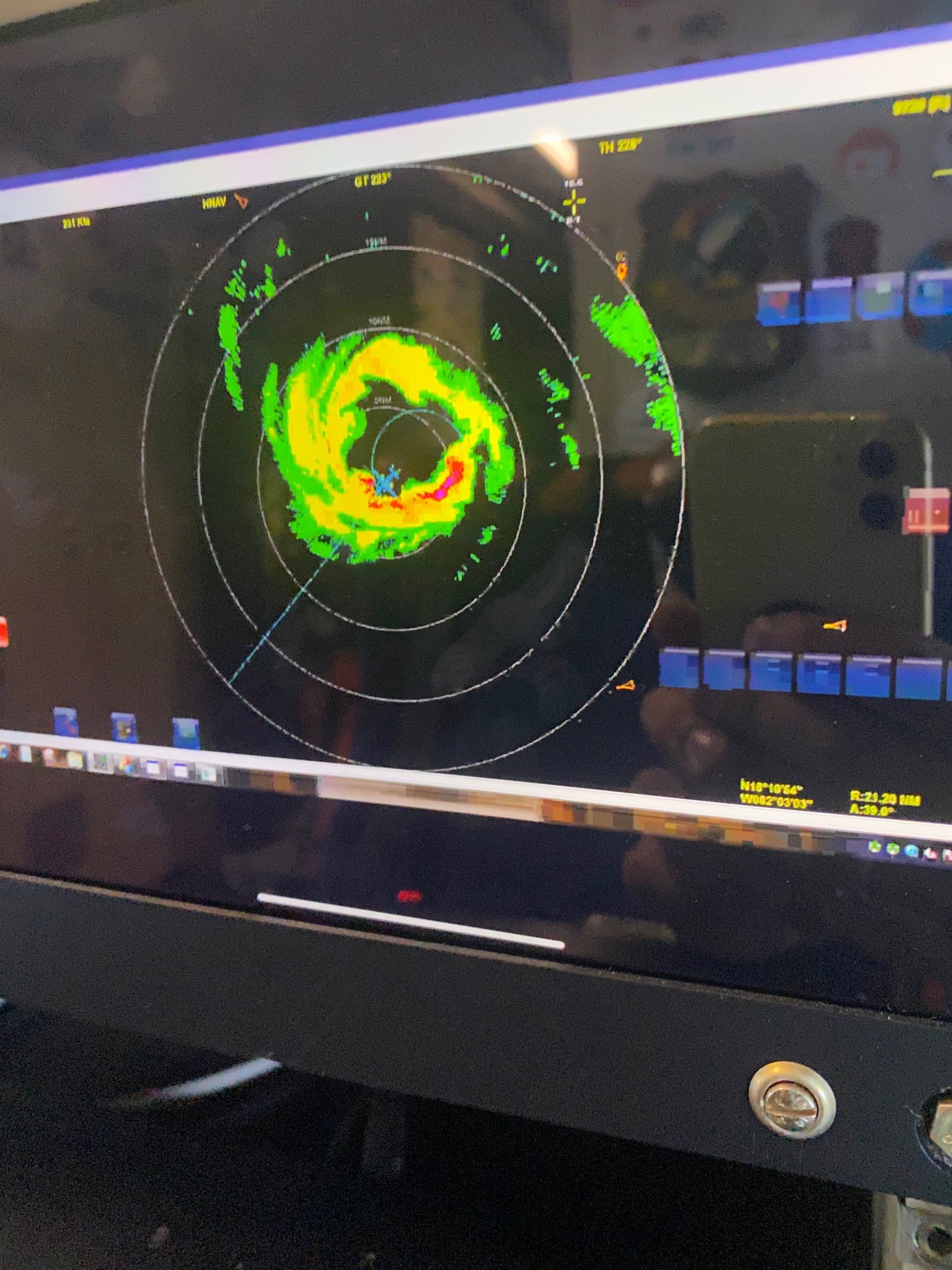
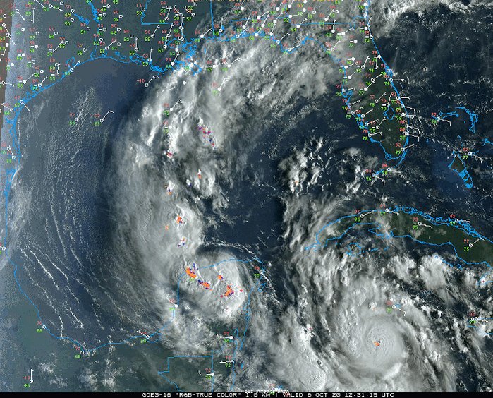
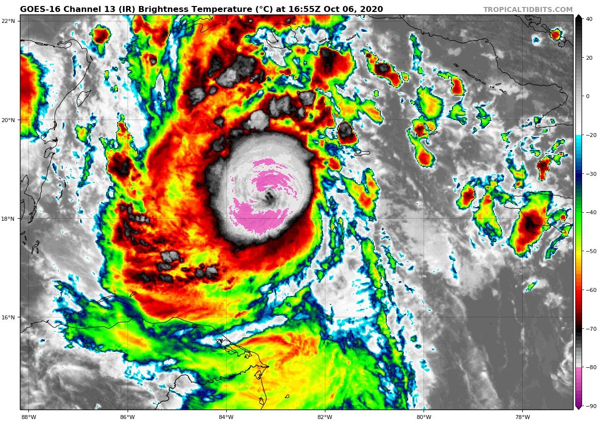
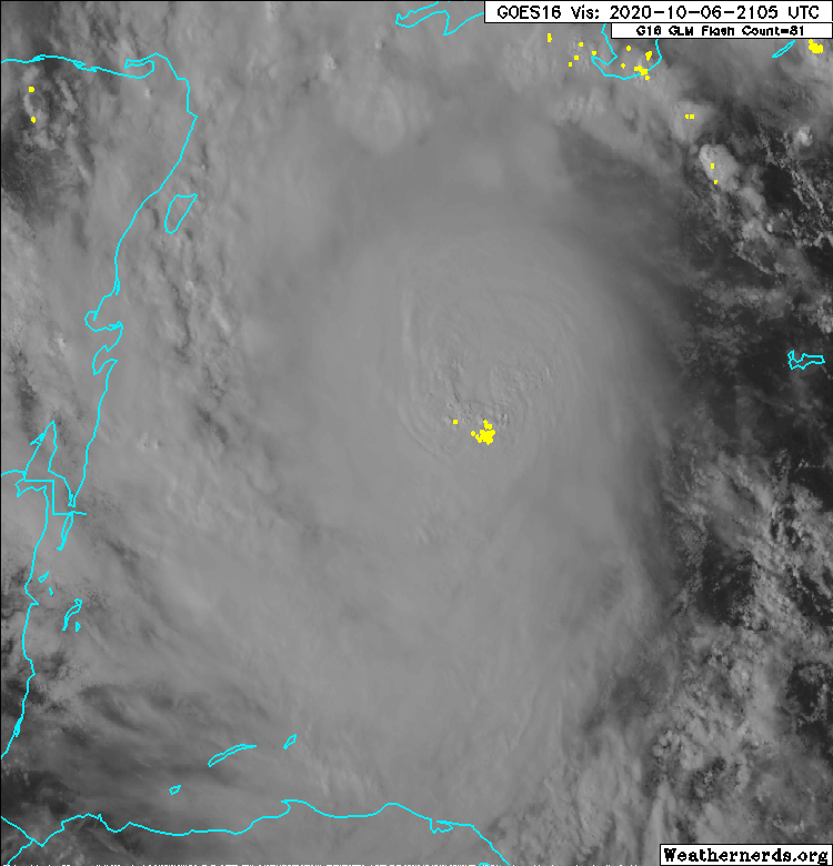
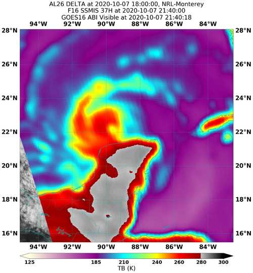
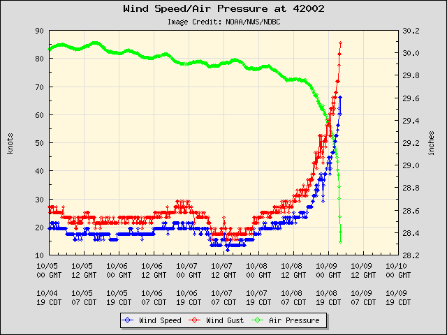
CAT4 1100hrs Oct6th - 954mb, 28.94", 285°@ 16mph, WNW, 130mph Sustained, Gusts 153mph, 16.5N 79.6W
Avatar
Glen Heinz (Greenville, SC) 04-Oct-20 09:12 PM
850mb and 500mb gfs 114 hrs 18z
GFS 114hrs showing 56knts/64mph 10m Winds Tropical Storm. (edited)
Really wondering if this gets just sheared?
Avatar
Avatar
Royce Sheibal (Papillion,NE) 04-Oct-20 09:48 PM
That microwave is angry
It wi get sheared but I think GFS is missing the RI over the next 3 days
Matrix of RI probabilities ------------------------------------------------------------------------------ RI (kt / h) | 20/12 | 25/24 | 30/24 | 35/24 | 40/24 | 45/36 | 55/48 |65/72 ------------------------------------------------------------------------------ SHIPS-RII: 7.8% 35.7% 19.9% 12.8% 10.0% 13.2% 37.7% 61.3%
SHIPS is up to 96kts by 84 hours
once we hit the 24 hour mark, it's predicting 2 straight days of 25kts/24hrs
rapid weakening is forecast once it hits peak, likely due to shear and dry air as it gets near the N gulf coast
but i feel like we coudl sneak in a major before it tops off and head out
Avatar
Glen Heinz (Greenville, SC) 04-Oct-20 10:09 PM
As TTB states the water temps near coastline is down in temp. That CCCF kinda helped out with that.
Avatar
Pat Kepka (Russell Co. KS) 04-Oct-20 10:13 PM
An interaction of some sort is probably inevitable now with Gamma’s trend in track
Avatar
Glen Heinz (Greenville, SC) 04-Oct-20 10:13 PM
Also wondering how this interacts with Possible Delta?
Interestingt o watch the next 24 hrs
Will gamma pull it further West or not much at all?
Avatar
Royce Sheibal (Papillion,NE) 04-Oct-20 10:21 PM
so based on normal fujiwhara patterns, i would expect 26 to more more west than expected, and for gamma to push south, once they get vertically aligned, they will detach and both go north
gamma will probably be pretty tilted or have a pretty bare center, so alot of its convectino will be beign fed into 26
Avatar
Glen Heinz (Greenville, SC) 04-Oct-20 10:23 PM
Galta
Avatar
Pat Kepka (Russell Co. KS) 04-Oct-20 10:38 PM
Tropical Depression #Twenty-Six Advisory 2: Disturbance Becomes a Tropical Depression. Forecast to Strengthen Over the Northwestern Caribbean Sea. https://t.co/VqHn0u1vgc
Avatar
Jacob Melton (Owosso, MI) 04-Oct-20 10:39 PM
Avatar
Joey Prom (Lafayette, IN) 04-Oct-20 11:19 PM
I am seriously considering chasing/intercepting this. If it shifts a bit east. Hurricane track had a good video discussing why to not write off the possibility it does not weaken prior to landfall.
Avatar
Royce Sheibal (Papillion,NE) 04-Oct-20 11:27 PM
It will by enhanced by the jet as it goes
whats the term... baroclinic instability?
could help maintain convection well into water that is cold AF near hte N gulf
Avatar
Joey Prom (Lafayette, IN) 04-Oct-20 11:37 PM
Also it will be moving relatively quickly, so it will not have too much time to be affected by the cooler water. If there is little wind shear, it could stay strong.
Avatar
Royce Sheibal (Papillion,NE) 05-Oct-20 12:15 AM
conveciton starting to cover the center. CDO may be forming. thats a huge burst going on right now
Avatar
Royce Sheibal (Papillion,NE) 05-Oct-20 12:23 AM
borderline cat 4 for HWRF and HMON. lock it in boys
there is a strong SW to NE gradient for OHC cuz of previous storms. 100 OHC ont he SW side of the path, <25 OHC on the NE side
sst's dont drop below 28 until the north turn, then it races north over 26C which isn't horrible if its going fast
Avatar
Glen Heinz (Greenville, SC) 05-Oct-20 12:35 AM
@Joey Prom (Lafayette, IN) I hope I can if it ramps up. Got to find someone to watch my kids. This is going to be short notice. Hey Joey you come here watch my kids and I'll go, deal?... lol (edited)
Avatar
Royce Sheibal (Papillion,NE) 05-Oct-20 12:36 AM
this def. has some flashbacks to Opal in my head
Avatar
Ian J. (Palm Beach County, FL) 05-Oct-20 12:37 AM
Lots of similarities, but the MPI in the north gulf simply isn't there
Avatar
Royce Sheibal (Papillion,NE) 05-Oct-20 12:38 AM
doesn't take much. michael wasn't above 70/80 in the north gulf. clearly we'll be below that
but if delta make cat 4 in the mid-gulf, its only got 24 hours to weaken as it moves north
Avatar
Ian J. (Palm Beach County, FL) 05-Oct-20 12:40 AM
Much higher SSTs for Michael, believe MPI was about 150kt?
Here we will undoubtedly see some weakening as 26L pulls north, maybe cat 1-2
We're talking SSTs under 25C on the shelf, which normally would hardly support a TS, but with the forward speed and some baroclinicity it should fare a little better
Avatar
Royce Sheibal (Papillion,NE) 05-Oct-20 12:44 AM
not sure what MPI on michael was, i dont have an archive at hand
atm, 150k extends up to the mid-gulf, then drops to 100 near the shelf
Avatar
Royce Sheibal (Papillion,NE) 05-Oct-20 01:00 AM
rammb doesn't have MPi data archived, lame. but their OHC had michael over <50 OHC, but its not very detailed data
Avatar
Royce Sheibal (Papillion,NE) 05-Oct-20 01:32 AM
satcon says we have a 996mb 40kt storm already
ADT is not as impressed
Avatar
Alex V (Wausau, WI) 05-Oct-20 03:47 AM
We will know for sure once HH goes in.
Avatar
Ethan T. (Notasulga, AL) 05-Oct-20 03:49 AM
Looking more and more like a tropical storm
Avatar
Alex V (Wausau, WI) 05-Oct-20 03:49 AM
Probably is a 35-40 knot TS currently. (edited)
Avatar
Ethan T. (Notasulga, AL) 05-Oct-20 03:55 AM
Considering it's smaller stature (main CDO pattern), increasing structured banding features, and increasingly open outflow channel(s), I wouldn't doubt 40-45kts (edited)
Avatar
Alex V (Wausau, WI) 05-Oct-20 05:03 AM
Still a TD as of 5 AM??
The NHC is not screwing around with their newest discussion.
They are going with 105 mph in 72 hours
And they mention "robust intensification" over the next day.
Avatar
Cameron (Fortson, GA) 05-Oct-20 07:32 AM
Doom
Avatar
Maladash (Palm Beach County, FL) 05-Oct-20 07:38 AM
Did that storm just πŸ‘Œ me?
Avatar
Cameron (Fortson, GA) 05-Oct-20 07:44 AM
It just πŸ‘Œ 'd all of us
Avatar
Alex V (Wausau, WI) 05-Oct-20 08:15 AM
Aight, now lets see what it will do with two days of bathwater and low shear and Gamma's moisture.
Avatar
Royce Sheibal (Papillion,NE) 05-Oct-20 08:52 AM
A lot of last night's global models had a hard fujiwhara with merger. Helped keep the storm offshore longer to weaken
But there were plenty of 960-970 landfals too
Avatar
Royce Sheibal (Papillion,NE) 05-Oct-20 09:09 AM
notice there is now a curved line of clouds from gamma to delta. a surface trough / convergence zone will form between them in a line. this is the start of fujiwhara. how long it lasts and how close they get is quite hard to predict
Avatar
Alex V (Wausau, WI) 05-Oct-20 09:17 AM
It's very possible it could help Delta stay in the bathwater more/miss Cuba as well. Also if it starts now it could plow Gamma into the Yucatan and kill it faster leaving Delta with less compeitition
Depending on how it goes the Fujiwhara could help it
Avatar
Royce Sheibal (Papillion,NE) 05-Oct-20 09:18 AM
looks like we've got rotating hot towers around the center now...eta 24 hours until it's a cane?
Avatar
Royce Sheibal (Papillion,NE) 05-Oct-20 09:38 AM
RIPA has MPI of 130kts up until the turn at 72 hours at least. storms of course normally dont hit MPI but dont count out an over-performer
Avatar
Alex V (Wausau, WI) 05-Oct-20 09:47 AM
Impressive, this thing is probably going to really start ramping up soon
Avatar
Royce Sheibal (Papillion,NE) 05-Oct-20 09:50 AM
Notice the large area of storms stretched along the old wave axis. There is just tons of pwet with this storm. And tons left over from gamma. Shear is under 10 kts for 24-48. Once the high aloft realigns this storm will be under literally perfect conditions.
Crazy hot tower just N of the center. Last gasp of Nmax before Dmin creeps in? Or is this the start of RI?
Avatar
Alex V (Wausau, WI) 05-Oct-20 09:56 AM
It already is sporting an eye-like feature. Not a true eye yet but might be the start of one later on
Avatar
Royce Sheibal (Papillion,NE) 05-Oct-20 10:12 AM
ay yes, the old false-eye between the towers....or is it?
there was a VERY clear IR response in that false eye for warming when that tower shot up
Avatar
Alex V (Wausau, WI) 05-Oct-20 10:16 AM
Possibly, but it would be weird for a true eye to appear only like 12 hours after development. (edited)
Avatar
Joey Prom (Lafayette, IN) 05-Oct-20 10:17 AM
@Joey Prom (Lafayette, IN) I hope I can if it ramps up. Got to find someone to watch my kids. This is going to be short notice. Hey Joey you come here watch my kids and I'll go, deal?... lol
@Glen Heinz (Greenville, SC) I want to chase it too Glen, thats the problem. I have one commitment on Friday, but I think I can swing it. The only problem is convincing my chasing partner @Jonathan DeGraw (IN) that it is a good idea.
Couple of questions: MPI? pwet?
Avatar
Ian J. (Palm Beach County, FL) 05-Oct-20 10:21 AM
At landfall MPI is around cat 1, but with fast motion could be around c2
MPI = max potential intensity
Avatar
Joey Prom (Lafayette, IN) 05-Oct-20 10:21 AM
ah
Avatar
Ian J. (Palm Beach County, FL) 05-Oct-20 10:22 AM
Out in the Caribbean and SE Gulf, MPI is cat 5, though who knows if it has time to get up there
Avatar
Alex V (Wausau, WI) 05-Oct-20 10:25 AM
NHC seems to be expecting a Cat 2 landfall.
Avatar
Joey Prom (Lafayette, IN) 05-Oct-20 10:26 AM
Mark Suddeths words: " While the official forecast does not yet call for Delta to become a major hurricane (category three or higher), I fully expect that we will see this happen and it would not shock me in the least to see it become at least as strong as Laura back in August." Damn!!!
Avatar
Royce Sheibal (Papillion,NE) 05-Oct-20 10:27 AM
PWET = precipitable water
Avatar
Alex V (Wausau, WI) 05-Oct-20 10:28 AM
That HT is sustaining, it threw up another overshooting top
Avatar
Royce Sheibal (Papillion,NE) 05-Oct-20 10:28 AM
PWET is pretty new to the hurricane world, but its becoming very important. i expect to see more places using it
PWET >2.0 is basically required for intensification, and PWET of 3.0 is often a sign of imminent RI
12z ships: Matrix of RI probabilities ------------------------------------------------------------------------------ RI (kt / h) | 20/12 | 25/24 | 30/24 | 35/24 | 40/24 | 45/36 | 55/48 |65/72 ------------------------------------------------------------------------------ SHIPS-RII: 18.4% 60.0% 41.7% 21.1% 17.7% 37.7% 43.2% 61.9% Logistic: 14.5% 56.1% 37.9% 10.3% 7.2% 30.8% 51.9% 67.2% Bayesian: 3.5% 50.5% 19.8% 3.8% 1.6% 23.9% 52.4% 42.6% Consensus: 12.1% 55.5% 33.2% 11.7% 8.8% 30.8% 49.2% 57.2%
FYI, that is the highest concensus for 65/72 ive seen, well, ever
MPI will clearly limit this storm, so it won't be some dorian, but the odds of it being a major hurricane are very very high at this point
Avatar
Joey Prom (Lafayette, IN) 05-Oct-20 10:38 AM
what goes in to determining MPI?
Avatar
Ian J. (Palm Beach County, FL) 05-Oct-20 10:42 AM
It's based on sea surface temps and oceanic heat content
A weakening storm moving into lower MPI can technically exceed it
Avatar
Joey Prom (Lafayette, IN) 05-Oct-20 10:42 AM
over the course of its projected path I assume?
Avatar
Ian J. (Palm Beach County, FL) 05-Oct-20 10:43 AM
These charts are a little unreliable near the shallow shelf but you get the idea
Avatar
Joey Prom (Lafayette, IN) 05-Oct-20 10:44 AM
Looking at the NHC track, they seem to want it to slow down just before it makes its northern turn. But that will still be over warm water. Then it accelerates again as it goes north. Its time over the cool water will be short.
Avatar
Royce Sheibal (Papillion,NE) 05-Oct-20 10:50 AM
this may be one of the few times that a fast-moving storm is bad for the coast
this 3
backup 3
Avatar
Alex V (Wausau, WI) 05-Oct-20 10:52 AM
ADT hates this storm, it has it weak and puts the center north of where it actually is.
Avatar
Joey Prom (Lafayette, IN) 05-Oct-20 10:52 AM
ADT?
NVM Advanced Dovorak right?
Avatar
Alex V (Wausau, WI) 05-Oct-20 10:56 AM
Avatar
Alex V (Wausau, WI) 05-Oct-20 11:04 AM
HT still sustaining
Avatar
Royce Sheibal (Papillion,NE) 05-Oct-20 11:05 AM
Adt doesn't like storms with broken convection. Its prefers blobs
Satcon is the better algorithm for this type of storm
Avatar
Alex V (Wausau, WI) 05-Oct-20 11:06 AM
It appears to be currently mixing out some dry air that has been entrained for the past few hours, could see some serious RI once it's done with that.
It has rapidly organized regardless of it though.
Avatar
Royce Sheibal (Papillion,NE) 05-Oct-20 11:07 AM
There was a trough to the north west last few days. Some higher level dry air up there. But surface air is WAP
Avatar
Alex V (Wausau, WI) 05-Oct-20 11:07 AM
WAP?
Avatar
Royce Sheibal (Papillion,NE) 05-Oct-20 11:07 AM
Wet a$& p$$ (edited)
Avatar
Alex V (Wausau, WI) 05-Oct-20 11:09 AM
ML is more important though for water vapor, right?
Avatar
Royce Sheibal (Papillion,NE) 05-Oct-20 11:10 AM
Mid level is the standard for dry air yes. But low level moisture will work upward over time, not just advect
Avatar
Norman Smith (Racine, OH) 05-Oct-20 11:11 AM
No.....please no WAP reference. Literally the worst song of all time, fuck Cardi B
this 1
Avatar
Alex V (Wausau, WI) 05-Oct-20 11:12 AM
The false-eye is still present on sat, has lasted pretty long, longer than false eyes on low-mid TSs usually last.
Avatar
Royce Sheibal (Papillion,NE) 05-Oct-20 11:29 AM
center appears to be under the main tower now. i expect a CDO to form soon
Avatar
Alex V (Wausau, WI) 05-Oct-20 11:29 AM
Latest advisory 1002/45 mph, but that could be underestimating it. NHC is calling for RI and expect it to reach hurricane status sooner, cone shifted a tad west due to center reformation.
Should be noted the center reformation threw a lot of the intensity models this cycle off, since many came in weaker while SHIPS and the environment still support high RI.
A lot of the intensity aids are assuming the storm isn't stacked still when it is
Which is what it is throwing them off
We should have a much better idea when HH enters the storm
Avatar
Royce Sheibal (Papillion,NE) 05-Oct-20 11:35 AM
its a T 3.5 to 4.0 at this time. so winds could be anywhere from 45mph to 65mph, i'm guessing lower since it will take a 6-12 hours for them to ramp up under new convection
Avatar
Ian J. (Palm Beach County, FL) 05-Oct-20 11:35 AM
That warm spot was just a gap between bands, but this dimple looks seriously like an eye now.
Avatar
Alex V (Wausau, WI) 05-Oct-20 11:37 AM
Ah, there's the real eye
Serious HT with lightning right next to it too
Avatar
Royce Sheibal (Papillion,NE) 05-Oct-20 11:43 AM
from CIMSS: Max Pot Int (MPI,from Emanuel) : 890.0 hPa MPI differential (MSLP-MPI) : 115.0 hPa
again, that's the top end. doubt it will happen, but this area is bathwater
Avatar
Alex V (Wausau, WI) 05-Oct-20 11:43 AM
890? Probably not, sub 940? Definitely possible.
Avatar
Royce Sheibal (Papillion,NE) 05-Oct-20 11:44 AM
ain't nobody got time to get down to 890mb
Avatar
Royce Sheibal (Papillion,NE) 05-Oct-20 11:52 AM
this being said. i present a reminder from the past
an old forecast that sounds very similar
Avatar
Alex V (Wausau, WI) 05-Oct-20 11:55 AM
That was Wilma, right?
Avatar
Royce Sheibal (Papillion,NE) 05-Oct-20 11:57 AM
it was yes. and this storm will cross wilma's path tonight 13 days before on the calendar
notice the 90kt wind speed error at 48 hours
Avatar
Alex V (Wausau, WI) 05-Oct-20 11:59 AM
What does 90kt error mean?
Is it a margin of error or a literal error?
Avatar
Royce Sheibal (Papillion,NE) 05-Oct-20 12:01 PM
the forecast was for 70kts overnight on the 19th. it was 160 IRL
Avatar
Royce Sheibal (Papillion,NE) 05-Oct-20 12:09 PM
looks like a gravity wave just blew through the western quadrant. clouds picking up
CI numbers spiking now. it's happening*
AMSU down to 992mb / 51kts. it could be taking off
Avatar
Zachary S (Jasper, AL) 05-Oct-20 12:21 PM
Not comparing peak strength but this is nearly identical to wilma's developing stage, tiny core with thick bands to the S and E, south of Jamaica
Avatar
Alex V (Wausau, WI) 05-Oct-20 12:22 PM
ADT still lagging but is putting the center in the proper place now.
Avatar
Zachary S (Jasper, AL) 05-Oct-20 12:22 PM
I'd be wary in Cozumel and the Caymans for sure
Avatar
Joey Prom (Lafayette, IN) 05-Oct-20 12:25 PM
So where are yall saying the center is on those radar loops?
Avatar
Royce Sheibal (Papillion,NE) 05-Oct-20 12:27 PM
the center is due SW of kingston
just E of the giant blob
Avatar
Joey Prom (Lafayette, IN) 05-Oct-20 12:28 PM
The northern blob with the purple hot tower?
Avatar
Royce Sheibal (Papillion,NE) 05-Oct-20 12:28 PM
bingo
Avatar
Joey Prom (Lafayette, IN) 05-Oct-20 12:28 PM
well, time to buckle up and watch the bomb explode today
Avatar
Ian J. (Palm Beach County, FL) 05-Oct-20 12:28 PM
Pretty easy to see on visible as a warm dimple on the eastern edge of the CDO
Avatar
Royce Sheibal (Papillion,NE) 05-Oct-20 12:28 PM
i'm def having wilma flashbacks right now, as well.
Avatar
Joey Prom (Lafayette, IN) 05-Oct-20 12:28 PM
But without the big hook to the east
Avatar
Parker Hughes (McKinney, Tx) 05-Oct-20 12:29 PM
Anyone know when there's suppose to be a recon mission in Delta?
Avatar
Joey Prom (Lafayette, IN) 05-Oct-20 12:29 PM
Delta is not going to have the ACE wilma had
right?
Avatar
Parker Hughes (McKinney, Tx) 05-Oct-20 12:29 PM
Will Delta fly into Delta?
Avatar
Joey Prom (Lafayette, IN) 05-Oct-20 12:30 PM
How much delta Knot will the storm have during its RI phase? Will it hit the MS delta? it may be hard to delta
Anyone know when there's suppose to be a recon mission in Delta?
@Parker Hughes (McKinney, Tx) This afternoon per NHC
Avatar
Zachary S (Jasper, AL) 05-Oct-20 12:36 PM
Avatar
Royce Sheibal (Papillion,NE) 05-Oct-20 12:36 PM
CDO with no lightning. coverage filling in. classic RI appearance
Avatar
Alex V (Wausau, WI) 05-Oct-20 12:37 PM
Thought lightning was indicative of RI?
Avatar
Ian J. (Palm Beach County, FL) 05-Oct-20 12:37 PM
Usually in systems of this intensity it's indicative of dry air
👍 2
Avatar
Joey Prom (Lafayette, IN) 05-Oct-20 12:37 PM
Man if that eye can close off in the next couple hours, this thing will literally explode
Also, this channel needs to be renamed, although at this rate we may just wait till it becomes a 'Cane
Avatar
Royce Sheibal (Papillion,NE) 05-Oct-20 12:45 PM
yup. lightning is usually in 1 of 2 stages of a hurricane - early on when it's fightning dry air, or very late in the RI period, when it's cat4+ and hail begins to form in the eyewall
Avatar
Joey Prom (Lafayette, IN) 05-Oct-20 12:50 PM
Is that why hurricanes rarely get hail? No dry air?
Avatar
Royce Sheibal (Papillion,NE) 05-Oct-20 12:51 PM
tropical storms don't use normal convection processes like temperate thunderstorms
Avatar
Joey Prom (Lafayette, IN) 05-Oct-20 12:52 PM
Please enlighten me
Avatar
Royce Sheibal (Papillion,NE) 05-Oct-20 12:52 PM
there is no ice in the low levesl, it's all super cooled water
bergeron process
Avatar
Joey Prom (Lafayette, IN) 05-Oct-20 12:53 PM
I have a strong academic background in fluid mechanics. Let me see
"begins reading wikipedia article"
Avatar
Royce Sheibal (Papillion,NE) 05-Oct-20 12:54 PM
wikipedia is a great source for intro to many concepts
Avatar
Alex V (Wausau, WI) 05-Oct-20 12:55 PM
The outer parts of a TC behave more like "normal" (low topped) convection/thunderstorms, but the further into the core you go you get more of a "warm" convection where the only way is up (rather than updraft/downdraft pairs like in normal convection) and it is warm on nearly all levels.
TC core convection blows it's outflow into the upper levels rather than using the typical updraft/downdraft method a (lets say) typical plains supercell does.
Avatar
Royce Sheibal (Papillion,NE) 05-Oct-20 12:56 PM
Avatar
Alex V (Wausau, WI) 05-Oct-20 01:00 PM
If a TC core is starting to behave more like a plains thunderstorm complex that usually means it is struggling.
Usually with dry air and shear.
This usually causes the cells to switch to the traditional "updraft/downdraft pair" setup, which dumps the outflow right into the core preventing it from strengthening
Avatar
Joey Prom (Lafayette, IN) 05-Oct-20 01:01 PM
So then where does the rain in the core come from?
For the typical TC core
Avatar
Alex V (Wausau, WI) 05-Oct-20 01:02 PM
It just falls
Much like it would in an HP updraft
The downdrafts of a healthy TC are in two places: The eye and outside the storm.
Avatar
Joey Prom (Lafayette, IN) 05-Oct-20 01:03 PM
I thought the eye was rising air?
(I am a total noob at this stuff btw, thanks for the help) (edited)
Avatar
Alex V (Wausau, WI) 05-Oct-20 01:04 PM
The eye contains a sinking air column, outflow air blown into the upper levels mostly spreads out and sinks outside of the storm though. The area just outside the storm and eye are calm and clear because of this. (edited)
Avatar
Joey Prom (Lafayette, IN) 05-Oct-20 01:06 PM
So if the eye is sinking air wouldn' that cause an increase in pressure? Also, is the low eye pressure related to the Bernoulli effect from the eye wall windspeed?
Avatar
Alex V (Wausau, WI) 05-Oct-20 01:07 PM
The sinking air column in the eye is a mere drop in the bucket when it comes to the insane updrafts of the core
Avatar
Joey Prom (Lafayette, IN) 05-Oct-20 01:07 PM
Are there any good youtube videos explaining these mechanics? Or good articles?
Avatar
Alex V (Wausau, WI) 05-Oct-20 01:07 PM
Net pressure trend is still low
Avatar
Joey Prom (Lafayette, IN) 05-Oct-20 01:08 PM
So does the eye have rising and sinking air, or is the rising air located in the eyewall Thunderstorms?
Avatar
Alex V (Wausau, WI) 05-Oct-20 01:08 PM
The eye has some sinking air, the eyewall has much more powerful updrafts though.
The eyewall updrafts are the drivers of the entire cyclone.
Also, with the exception of the eyewall a TC is generally a low-CAPE environment, so even in the outer bands where cells behave more traditionally and thunderstormy they tend to be low-topped and updrafts not very powerful. (edited)
The powerful shit is in the eyewall when it comes to updrafts
Avatar
Joey Prom (Lafayette, IN) 05-Oct-20 01:10 PM
The storm essentially creates its own CAPE near the core right? Through whipping up the waves and spiking the moisture
Avatar
Alex V (Wausau, WI) 05-Oct-20 01:13 PM
Pretty much, yes. The inner bands and eyewall tend to be self-sustaining in a way that the traditional notions of enviromental CAPE can be thrown out.
As soon as the eyewall is disrupted the entire storm weakens because the vast majority of convective energy is concentrated there, and in a mature hurricane is nearly the sole driver of the storm.
Avatar
Royce Sheibal (Papillion,NE) 05-Oct-20 01:18 PM
you have to think of a plains supercell as a fire that consumes fuel (cape). where as a tropical system is more like an engine that consumes heat and moisture, only to feed back into itself like a super-charger
Avatar
Joey Prom (Lafayette, IN) 05-Oct-20 01:18 PM
So circling back a bit, the lack of hail is in part attriubuted to the powerful updrafts chucking the moist air far away from the center at high altitude?
Avatar
Royce Sheibal (Papillion,NE) 05-Oct-20 01:18 PM
hail requires 2 things in order to form - a downdraft, and ice particles
neither are present in a mature storm
small hail does tend to form in a high end hurricane because the updrafts become cold enough to form ice (below -40C)
Avatar
Joey Prom (Lafayette, IN) 05-Oct-20 01:20 PM
Well, it needs a very strong updraft too, to keep the ice particles in the upper part of the troposphere where its freezing. But in a tropical storm, is it just too warm at all levels, until the wind becomes too strong and it blows all the water vapor out and away from the center?
Thanks btw, I am learning a ton
Avatar
Royce Sheibal (Papillion,NE) 05-Oct-20 01:21 PM
-39 C is too warm for ice in supercooled air
Avatar
Alex V (Wausau, WI) 05-Oct-20 01:22 PM
The closest land analogue to a TC would be a derecho, but even then it is an apples to oranges comparison because a derecho's self sustaining feedback loop is by sustaining itself with it's own downdraft + forward speed.
👍 2
Avatar
Joey Prom (Lafayette, IN) 05-Oct-20 01:22 PM
Is that higher temperature due to the ambient condition (the tropics are warm) or is it due to the larger amount of latent heat (Due to the huge amount of energy involved in a TC)
Avatar
Royce Sheibal (Papillion,NE) 05-Oct-20 01:23 PM
its because the physical process for precip in the tropics doesnt' involve accretion onto a piece of dust like in temperate storms. it involves super-cooled particles pumping into eachother until they get to big to updraft and then they fall, and the falling rain won't freeze because of adiabatic processes
Avatar
Alex V (Wausau, WI) 05-Oct-20 01:26 PM
Tropical oceans anyways, tropical land thunderstorms are a typical super high-CAPE but really low-shear environment.
Avatar
Royce Sheibal (Papillion,NE) 05-Oct-20 01:27 PM
yup, has to do with the lapse rate beign muuch higher in tropical areas. parcels just 'go up' until they hit the tropopause
Avatar
Alex V (Wausau, WI) 05-Oct-20 01:28 PM
Though land thunderstorms in the tropics still have downdrafts. The oceanic based ones are the ones that behave more like that.
Avatar
Joey Prom (Lafayette, IN) 05-Oct-20 01:30 PM
So is that why hurricanes (to me anyways) never seem to be as impressive on radar, than say a plains thunderstorm. They just have far fewer ice particles of any reasonable size. Its all smaller supercooled water droplets. But even though its only yellows and orange, its still torrential rain.
Avatar
Alex V (Wausau, WI) 05-Oct-20 01:30 PM
Should be noted that the tropics don't receive much in the way of severe weather like tornadoes and damaging winds (outside of TCs) like the mid-latitudes do, mostly due to the fact most severe events need shear to organize.
@Joey Prom (Lafayette, IN) Less hail plus most of the convec is low-topped outside of the core (edited)
Plains cores tend to be filled with hail, even if it doesn't reach the ground.
Avatar
Joey Prom (Lafayette, IN) 05-Oct-20 01:31 PM
I was going to say, I thought u just explained that the core storms rise till they hit the tropopause. Thanks for clarifying
Avatar
Alex V (Wausau, WI) 05-Oct-20 01:34 PM
Also should be noted severe convection typically results from clashing of air masses, doesn't happen much in the tropics, however the uniform airmass is what allows TCs to form.
👍 1
Avatar
Royce Sheibal (Papillion,NE) 05-Oct-20 01:34 PM
let me see if i can find a good cross-section of cloud heights
Avatar
Joey Prom (Lafayette, IN) 05-Oct-20 01:34 PM
So is there a better product to use on the radar to tell how much rain is happening than reflectivity? Or do I just need to adjust what I think of for heavy rain.
Avatar
Royce Sheibal (Papillion,NE) 05-Oct-20 01:34 PM
the overshooting tops cause the impressive high clouds, but underneath the storms are actually quite short in the bands
Avatar
Joey Prom (Lafayette, IN) 05-Oct-20 01:35 PM
Yea, this makes sense to me for sure.
Avatar
Royce Sheibal (Papillion,NE) 05-Oct-20 01:35 PM
those low, short clouds are very similar to low-topped mini-supercells in the midwest, and that's why they often form tornadoes
Avatar
Joey Prom (Lafayette, IN) 05-Oct-20 01:36 PM
Cause their downdrafts interact with the ground and create shear
Avatar
Alex V (Wausau, WI) 05-Oct-20 01:36 PM
Depends, they can be low-topped squall line equivlents too
Depending on shear enviroment
Avatar
Royce Sheibal (Papillion,NE) 05-Oct-20 01:36 PM
there is a tiny zone between the updraft and the eye, in the eyewall, where meso-vorticies happen. they are like mini-HP supercells in the eyewall. that's where the really intense winds come from
Avatar
Alex V (Wausau, WI) 05-Oct-20 01:36 PM
I'd say treat the outer bands on radar like a low-topped heavy cell, assume the rainrate is much higher than you'd assume on the plains.
Avatar
Royce Sheibal (Papillion,NE) 05-Oct-20 01:37 PM
rain rates in plains storms often beat tropical, no problem, its about consistency
Avatar
Joey Prom (Lafayette, IN) 05-Oct-20 01:38 PM
So do the meso vorts form from the vertical shear of the rising updrafts and the sinking eye downdraft. Plus the rapid circular motion of the eyewall storms
Avatar
Royce Sheibal (Papillion,NE) 05-Oct-20 01:38 PM
you can get rain rates of 1" per minute in a supercell, but it wont' sustain for an hour. where as a tropical system can do 3" per hour for 24 hours
Avatar
Alex V (Wausau, WI) 05-Oct-20 01:38 PM
Mesovorticies usually are not considered for sustained windspeeds in the updates, though, mesovorticy winds are usually chalked up as "gusts"
Avatar
Royce Sheibal (Papillion,NE) 05-Oct-20 01:38 PM
there has been some pretty interesting obs coming out of laura's landfall, and that the meso-vorts might actually be a much bigger part of the eyewall than previously thought
Avatar
Alex V (Wausau, WI) 05-Oct-20 01:39 PM
Most of the eyewall winds are driven by the updraft convection alone, the mesovorts result in the peak gusts though.
Avatar
Royce Sheibal (Papillion,NE) 05-Oct-20 01:40 PM
previously we had thought that yes, but it's looking like meso-vorts are more ever-present in high end storms than expected. they aren't transient 1 or 2 at at time, but rather a continuous process
Avatar
Alex V (Wausau, WI) 05-Oct-20 01:41 PM
The issue with that theory is that eyewall winds are sustained, not gusty.
Avatar
Royce Sheibal (Papillion,NE) 05-Oct-20 01:42 PM
but what if they are sustained through a series of overlapping gusts? a signal through a noise?
Avatar
Joey Prom (Lafayette, IN) 05-Oct-20 01:43 PM
the storms r really wipping around, so it wouldnt take too many meso vorts to make it seem like sustained
Were we able to get lots of good data from Laura? Is it going to maybe become the el Reno of hurricane research?
Avatar
Royce Sheibal (Papillion,NE) 05-Oct-20 01:45 PM
there was a decent amount, i expect alot of papers about it
Avatar
Alex V (Wausau, WI) 05-Oct-20 01:46 PM
Most of the winds though are updraft and pressure-driven. Mesovorts really count for absolute peak/highest gusts. Pressure gradient is also very tightly packed in the core, so it's like a pressure/inflow hybrid wind.
Avatar
Matthew Harding (Wichita, KS) 05-Oct-20 01:48 PM
Up to 60 mph/998 mb.
Avatar
Alex V (Wausau, WI) 05-Oct-20 01:49 PM
Where do you see that?
Avatar
Royce Sheibal (Papillion,NE) 05-Oct-20 01:49 PM
the question is, does a strong hurricane create strong meso-vorts, or do strong-meso vorts make the strong hurricane? a chicken/egg argument clearly. we previously had stuck to the prior but perhaps we need to look at the later?
Avatar
Alex V (Wausau, WI) 05-Oct-20 01:49 PM
Honestly?
In my opinion, it's both
Simultaneously
Avatar
Royce Sheibal (Papillion,NE) 05-Oct-20 01:50 PM
i agree, but that means our concept of estimating hurricanes only with sustained 1 minutes / 10 minute winds are then outdated
Avatar
Alex V (Wausau, WI) 05-Oct-20 01:51 PM
The strong updrafts and tight pressure create the winds and the environment for mesovorts, mesovorts create more winds and if they stack it could become a tight inner band of winds helping lower pressure more.
Avatar
Royce Sheibal (Papillion,NE) 05-Oct-20 01:51 PM
2pm public is out, there's your 60mph
Avatar
Alex V (Wausau, WI) 05-Oct-20 01:52 PM
If 1 min/10 min sustained is outdated for windspeeds, then what do we use?
Frequent Gusts like we use for ETCs and severe thunderstorms? (edited)
Avatar
Joey Prom (Lafayette, IN) 05-Oct-20 01:53 PM
So, does the low pressure in a hurricane come from the Bernoulli effect from the eyewall winds?
Avatar
Alex V (Wausau, WI) 05-Oct-20 01:53 PM
Updraft + winds
Updraft + winds = lower pressure = stronger updraft + winds.
Avatar
Joey Prom (Lafayette, IN) 05-Oct-20 01:53 PM
yup
So, would the highest pressure be located in the eyewall and not the eye? Due to the sinking air in the eye itself?
Avatar
Royce Sheibal (Papillion,NE) 05-Oct-20 01:55 PM
i like the frequent gust suggestion, but i'm a fan of integrated kinetic energy
🇮 1
🇰 1
🇪 1
Avatar
Alex V (Wausau, WI) 05-Oct-20 01:55 PM
I mean for windspeed forecast
Avatar
Royce Sheibal (Papillion,NE) 05-Oct-20 01:55 PM
the sinking air isnt' enough to re-pressureize the eye or the eyewall. its very slow
Avatar
Ian J. (Palm Beach County, FL) 05-Oct-20 01:55 PM
There's a video of them flying into Hurricane Isaias that shows off structure really well
Lemme see if I can find it
Avatar
Royce Sheibal (Papillion,NE) 05-Oct-20 01:57 PM
the majority of conservation of pressure going on in the storm is made by the outward/upward winds within the eyewall and then into the CDO
we're ahead of the RI forecast, guys. not a great sign
Avatar
Joey Prom (Lafayette, IN) 05-Oct-20 01:59 PM
This is almost like new ground right, having conditions that are this prime for this length of time
Avatar
Royce Sheibal (Papillion,NE) 05-Oct-20 02:00 PM
not really, this is pretty much 2017/2018/2005 all over again
Avatar
Joey Prom (Lafayette, IN) 05-Oct-20 02:01 PM
I mean as far as models having a small sample size to validate accuracy under this type of RI conditions
Avatar
Alex V (Wausau, WI) 05-Oct-20 02:02 PM
My main problem with the 1 minute sustained wind thing is that the rest of NWS/NOAA uses 2 minute sustained for anything else. 50 mph in a TC are measured in shorter duration than 50 mph from an extratropical cyclone event, so it's not going to be consistent to everyone.
Avatar
Joey Prom (Lafayette, IN) 05-Oct-20 02:02 PM
Eye trying to show up a bit on the visible
Avatar
Royce Sheibal (Papillion,NE) 05-Oct-20 02:02 PM
well, if we consider 100 to be a standard sample size, yes, we are low on the number of 'confirms' for samples, but if we count all the waves that failed to grow under these conditions? hard to say
we've got maybe, what, 20 major hurricanes in the month of october in the carib. to compare to?
Avatar
Joey Prom (Lafayette, IN) 05-Oct-20 02:03 PM
New towers going up on the N NNE side of the low
Avatar
Royce Sheibal (Papillion,NE) 05-Oct-20 02:03 PM
but we probably have seen 400+ waves in the satelite era to analyze
Avatar
Alex V (Wausau, WI) 05-Oct-20 02:04 PM
Convec subsiding a little bit, still robust, I'd watch for another flare though.
Avatar
Joey Prom (Lafayette, IN) 05-Oct-20 02:04 PM
The flare is ongoing
Avatar
Royce Sheibal (Papillion,NE) 05-Oct-20 02:04 PM
its Dmin. expect a pause. wait for Nmax. gonna be nuts
Avatar
Joey Prom (Lafayette, IN) 05-Oct-20 02:05 PM
Just over the past 10 minutes, new towers have fired
Avatar
Ian J. (Palm Beach County, FL) 05-Oct-20 02:05 PM
It's clearly still firing eyewall convection
Avatar
Alex V (Wausau, WI) 05-Oct-20 02:05 PM
It is, but not as intensely as earlier
Avatar
Royce Sheibal (Papillion,NE) 05-Oct-20 02:06 PM
right now shear is from the east, yes the east. wait until we seee up-shear towers. then it's go-time
Avatar
Joey Prom (Lafayette, IN) 05-Oct-20 02:06 PM
So more on the east side?
Avatar
Royce Sheibal (Papillion,NE) 05-Oct-20 02:06 PM
the big towers right now are all on the down-shear side
Avatar
Alex V (Wausau, WI) 05-Oct-20 02:06 PM
It's definitely strengthening, but it is showing the effects of DMIN
Avatar
Royce Sheibal (Papillion,NE) 05-Oct-20 02:06 PM
upshear towers are a dead-giveaway for RI.
Avatar
Ian J. (Palm Beach County, FL) 05-Oct-20 02:07 PM
I've noticed CDO convection weakens a little as an eye clears. Doesn't indicate a pause in strengthening
Avatar
Joey Prom (Lafayette, IN) 05-Oct-20 02:07 PM
upshear would be on the east side? (edited)
this 1
Avatar
Royce Sheibal (Papillion,NE) 05-Oct-20 02:07 PM
lunch time. lets see waht the models do now
Avatar
Alex V (Wausau, WI) 05-Oct-20 02:07 PM
Anyways, I never understood why we use 1 minute sustained for TC windspeeds but 2 minute for non TC windspeeds.
Avatar
Ian J. (Palm Beach County, FL) 05-Oct-20 02:09 PM
1-min has been standardized for estimations and reduction
Just easier to estimate
Avatar
Parker Hughes (McKinney, Tx) 05-Oct-20 02:10 PM
Looks like both the HWRF and the HMON did not initialize very well
Avatar
Joey Prom (Lafayette, IN) 05-Oct-20 02:10 PM
Looks like some eastern eye storms firing to me
Avatar
Alex V (Wausau, WI) 05-Oct-20 02:11 PM
@Parker Hughes (McKinney, Tx) Intensity models were thrown off by the center relocation, 06z runs lowballed it as a result.
Avatar
Royce Sheibal (Papillion,NE) 05-Oct-20 02:16 PM
What if I told you we are now ahead of the ships forecast for RI.
Avatar
Alex V (Wausau, WI) 05-Oct-20 02:17 PM
Really?
Avatar
Royce Sheibal (Papillion,NE) 05-Oct-20 02:17 PM
Once the RIPA updates I'll post it. Were ahead of schedule
😰 2
Hank 2
category5 2
😜 2
Avatar
Alex V (Wausau, WI) 05-Oct-20 02:19 PM
That popped up quick
That new HT is going crazy
Avatar
Joey Prom (Lafayette, IN) 05-Oct-20 02:25 PM
I told you. Its getting towards the upshear side too
Mark Suddeth saying " At least Cat 4..." in the Caribbean.
Avatar
Alex V (Wausau, WI) 05-Oct-20 02:26 PM
I don't know much about Mark, how reliable is he?
Avatar
Royce Sheibal (Papillion,NE) 05-Oct-20 02:27 PM
Mark knows hurricanes pretty well
Avatar
Alex V (Wausau, WI) 05-Oct-20 02:29 PM
Delta has a mean visible presentation
Avatar
Royce Sheibal (Papillion,NE) 05-Oct-20 02:30 PM
^that's wilma over the same spot, btw
Avatar
Alex V (Wausau, WI) 05-Oct-20 02:30 PM
Delta actually looks better than that right now
Avatar
Royce Sheibal (Papillion,NE) 05-Oct-20 02:31 PM
there is a little bit of dry air ahead on the NW side, like levi said, and a little more shear than ideal in 24 hours, but otherwise i dont see any reason why we can't cat 4 this
Avatar
Joey Prom (Lafayette, IN) 05-Oct-20 02:32 PM
Delta wont recurve over water though. So not the ACE machine. Are we saying Delta may reach similar max intensity though?
Avatar
Alex V (Wausau, WI) 05-Oct-20 02:32 PM
By 24 hours it will probably be well-structured enough to hold out dry air and have an upper level anticyclone to hold off shear.
Avatar
Royce Sheibal (Papillion,NE) 05-Oct-20 02:33 PM
Avatar
Alex V (Wausau, WI) 05-Oct-20 02:33 PM
Looks similar to Delta
Avatar
Hunter Hollman (York, PA) 05-Oct-20 02:34 PM
The dates line up eerily well, same area off by ~2 weeks
Avatar
Alex V (Wausau, WI) 05-Oct-20 02:34 PM
This was Delta 12 hours ago
This loop is terrifying
This shows Delta going from a slightly-swirling cloud mass to a 60+ mph TS
Avatar
Joey Prom (Lafayette, IN) 05-Oct-20 02:44 PM
Royce do you have those SHIPS values?
Avatar
Royce Sheibal (Papillion,NE) 05-Oct-20 02:47 PM
waiting for ripa and ships 18z runs
Avatar
Joey Prom (Lafayette, IN) 05-Oct-20 02:47 PM
ah
Avatar
Royce Sheibal (Papillion,NE) 05-Oct-20 02:47 PM
after the 2pm advisory came out they might have started them late
Avatar
Joey Prom (Lafayette, IN) 05-Oct-20 02:48 PM
The other big event is the HH plane
I see convective towers firing on the east rn
Just starting to poke through on visible
Right at the end, new towers to the east.
Avatar
Royce Sheibal (Papillion,NE) 05-Oct-20 02:56 PM
this looks like a WPAC typhoon getting ready to drop 60mb in 24 hours
Avatar
Alex V (Wausau, WI) 05-Oct-20 02:58 PM
Who's to say it isn't near hurricane already?
this 4
East 3
Avatar
Pat Kepka (Russell Co. KS) 05-Oct-20 03:02 PM
18z SHIPS
Matrix of RI probabilities ------------------------------------------------------------------------------ RI (kt / h) | 20/12 | 25/24 | 30/24 | 35/24 | 40/24 | 45/36 | 55/48 |65/72 ------------------------------------------------------------------------------ SHIPS-RII: 50.9% 95.1% 68.7% 58.2% 56.0% 87.3% 51.4% 62.8% Logistic: 39.1% 77.2% 64.7% 39.0% 30.3% 54.7% 60.1% 60.6% Bayesian: 23.3% 92.2% 70.3% 38.5% 34.2% 70.7% 15.3% 26.6% Consensus: 37.8% 88.2% 67.9% 45.2% 40.2% 70.9% 42.3% 50.0% DTOPS: 13.0% 70.0% 40.0% 45.0% 2.0% 23.0% 42.0% 1.0%
(edited)
Avatar
Hunter Hollman (York, PA) 05-Oct-20 03:02 PM
NHC pretty conservative on their forecast I see
Avatar
Joey Prom (Lafayette, IN) 05-Oct-20 03:02 PM
That will change very quickly (edited)
Avatar
Hunter Hollman (York, PA) 05-Oct-20 03:02 PM
Yikes, those values are no joke
Avatar
Pat Kepka (Russell Co. KS) 05-Oct-20 03:02 PM
87% for 45/36h (edited)
Avatar
Joey Prom (Lafayette, IN) 05-Oct-20 03:04 PM
I know its a plains meme, but I think the basic principle also applies to the tropics
Avatar
Matthew Harding (Wichita, KS) 05-Oct-20 03:05 PM
The 63% chance for a 65 kt increase in 72 hrs is no slouch either. (edited)
Hank 3
backup 3
Avatar
Joey Prom (Lafayette, IN) 05-Oct-20 03:06 PM
That would put it at 135 mph (117 kt)
category4 8
Avatar
Royce Sheibal (Papillion,NE) 05-Oct-20 03:07 PM
the 95% of 25/24 is insane. ive never seen anything that high on ships
👀 6
Avatar
Joey Prom (Lafayette, IN) 05-Oct-20 03:07 PM
You can see the towers rotating around the western side of the "eye"
Will it beat out Laura as the most intense 'Cane of the 2020 season. That is the question up for debate over the next few days.
Avatar
Alex V (Wausau, WI) 05-Oct-20 03:09 PM
Laura was near Cat 5, possibly was Cat 5, hard to beat, but who's to say it won't go crazy in the bathwater before heading to the cooler waters in the gulf? (edited)
this 1
Avatar
Royce Sheibal (Papillion,NE) 05-Oct-20 03:10 PM
ships now has 107-114kts max intensity forecast
SHIPS Prob RI for 40kt/ 24hr RI threshold= 56% is 22.4 times climatological mean ( 2.5%)
Avatar
Joey Prom (Lafayette, IN) 05-Oct-20 03:10 PM
So it must not know about the current 60 mph sustained winds
Avatar
Royce Sheibal (Papillion,NE) 05-Oct-20 03:11 PM
it had 50kts as the run winds. so its going for +57-64kts on average
22x climatology....is unheard of
category2 4
β­• 3
2️⃣ 2
0️⃣ 2
lock it in boys
Avatar
Joey Prom (Lafayette, IN) 05-Oct-20 03:12 PM
More like buckle up and enjoy the spectacle of natures fury
Avatar
Royce Sheibal (Papillion,NE) 05-Oct-20 03:15 PM
Run at 50 kts. 115 kts over 50%
Avatar
Joey Prom (Lafayette, IN) 05-Oct-20 03:20 PM
almost a coin flip for 70kt/48 hr
category4 7
Now we wait for recon
Avatar
Royce Sheibal (Papillion,NE) 05-Oct-20 03:25 PM
I think they will find winds aren't that impressive. It might take longer to spin up than currently we guessed
Avatar
Alex V (Wausau, WI) 05-Oct-20 03:26 PM
Winds typically are slower to respond in these weaker systems, but I won't doubt 65-70 mph
Here we go
Avatar
Pat Kepka (Russell Co. KS) 05-Oct-20 03:41 PM
985.6 mb extrap
54 knot peak in the NW quad
Avatar
Hunter Hollman (York, PA) 05-Oct-20 03:42 PM
Something tells me we're witnessing the birth of a beast
Avatar
Royce Sheibal (Papillion,NE) 05-Oct-20 03:42 PM
towers going up like hotcakes. in all quads.
its pumping so hard they might enter the storm as a storm, and leave it as a cane
Avatar
Joey Prom (Lafayette, IN) 05-Oct-20 03:45 PM
lol. I've been saying, we need to rename this channel to Hurricane Delta. Its inevitable anyways.
And just to clarify, this is happening around DMIN?
Avatar
Royce Sheibal (Papillion,NE) 05-Oct-20 03:46 PM
diurnal minimum
vs nocturnal maximum
Avatar
Joey Prom (Lafayette, IN) 05-Oct-20 03:46 PM
"faints"
Avatar
Royce Sheibal (Papillion,NE) 05-Oct-20 03:47 PM
cloud tops tend to be coldest and most centralized in the early AM hours
and they are the most spread out and warmest by afternoon
this causes the appearance, or often actual difference, that storms are stronger at night than during the day (edited)
Avatar
Joey Prom (Lafayette, IN) 05-Oct-20 03:48 PM
"faints again"
Avatar
JoshuaClark 05-Oct-20 03:48 PM
Damn , Delta is just turnin and burnin. It has really came together bigtime today.
Avatar
Royce Sheibal (Papillion,NE) 05-Oct-20 03:49 PM
i'm locked in at cat 4. anyone buying cat 5?
category4 4
Avatar
Ethan T. (Notasulga, AL) 05-Oct-20 03:50 PM
I’ll buy 145kts Royce?
Avatar
Royce Sheibal (Papillion,NE) 05-Oct-20 03:50 PM
i'll buy you dinner if this hits 145kts
Avatar
JoshuaClark 05-Oct-20 03:50 PM
I just cannot wait until the tropical cyclone cannibalism that we are going to see. Whose game to watch Delta gobble up Gamma.
Avatar
Joey Prom (Lafayette, IN) 05-Oct-20 03:51 PM
What a season. I feel we need a Cat 5 though to truly say 2020 is "comparable to" 2005. Not saying its equal, but at least then it would be on a similar level.
Avatar
Royce Sheibal (Papillion,NE) 05-Oct-20 03:52 PM
wow look at that SE quad flight winds. that' isn't even the impressive side
Avatar
Joey Prom (Lafayette, IN) 05-Oct-20 03:54 PM
where do you go to see the racon data?
Avatar
JoshuaClark 05-Oct-20 03:55 PM
Check out the SE quad!
Avatar
Jonathan DeGraw (IN) 05-Oct-20 03:55 PM
@Joey Prom (Lafayette, IN) https://www.tropicaltidbits.com/recon/
Live updating recon data for the Atlantic basin
👍 1
Avatar
Alex V (Wausau, WI) 05-Oct-20 03:57 PM
Tiny eye
Avatar
Royce Sheibal (Papillion,NE) 05-Oct-20 03:57 PM
ring of fire towers forming around the center now
Avatar
Alex V (Wausau, WI) 05-Oct-20 03:57 PM
What will the NE quad pass reveal?
Avatar
Royce Sheibal (Papillion,NE) 05-Oct-20 03:57 PM
tiny eye = good for RI
Avatar
Ian J. (Palm Beach County, FL) 05-Oct-20 03:59 PM
Convectively it looks like we really are seeing the diurnal effects now. Small systems like this seem especially prone to diurnal pulsing
Avatar
Royce Sheibal (Papillion,NE) 05-Oct-20 04:01 PM
we'll have to wait for tonight before teh monster CDO forms and the eye pokes out finally
Avatar
Ian J. (Palm Beach County, FL) 05-Oct-20 04:01 PM
I would bet we start getting hints at a clear eye as the sun rises
Avatar
Alex V (Wausau, WI) 05-Oct-20 04:02 PM
Avatar
Joey Prom (Lafayette, IN) 05-Oct-20 04:07 PM
The circle at the end of the IR loop is just a collapsing thunderstorm right? Its not an eye? right?
Avatar
Royce Sheibal (Papillion,NE) 05-Oct-20 04:09 PM
correct
Avatar
Joey Prom (Lafayette, IN) 05-Oct-20 04:10 PM
Its close to where the "eye" would be. There are more towers going up in a perfect arc along the NE side. Those Recons boys and gals are in for a fun time there.
Avatar
Glen Heinz (Greenville, SC) 05-Oct-20 04:25 PM
Man I'm tired. What happened?! 181 messages.. gee wizzy.
Avatar
Zachary S (Jasper, AL) 05-Oct-20 04:29 PM
983 extrap
This goin fast so far
Avatar
Joey Prom (Lafayette, IN) 05-Oct-20 04:29 PM
Sorry glen, My curiosity and bottomless well of questions caused about half of those... πŸ˜‰
The other half are just gawking at the ridiculous RI probabilities
Avatar
Andy H. (Asheville, NC) 05-Oct-20 04:31 PM
getting to watch something similar to what happened to Wilma in real time is very exciting
Avatar
Alex V (Wausau, WI) 05-Oct-20 04:33 PM
New hot tower
Avatar
Joey Prom (Lafayette, IN) 05-Oct-20 04:33 PM
Well time to go biking for 2 hours. I am expecting Delta to be a hurricane by that point. I will be sorely disappointed if it isn't... Yao
Avatar
Alex V (Wausau, WI) 05-Oct-20 04:34 PM
They will probably find hurricane-force winds in that area where the HTs keep spawning
If not this pass then within the next couple
Avatar
Hunter Hollman (York, PA) 05-Oct-20 04:34 PM
18 nm eye, about 20 miles
Avatar
Alex V (Wausau, WI) 05-Oct-20 04:35 PM
Open WNW with 55 knot winds in that area.
Oh boy...
Avatar
Joey Prom (Lafayette, IN) 05-Oct-20 04:35 PM
whats that mean?
Avatar
Alex V (Wausau, WI) 05-Oct-20 04:36 PM
Strong winds in the part of the eyewall without convection is indicative of a strengthening system
👍 1
The eye isn't closed yet and we are already seeing 65 mph winds on the "weaker" side
Avatar
Justin | @Helicity (Houma, LA) 05-Oct-20 04:40 PM
I'm done with this season. I'm supposed to be getting married on the MS Gulf Coast on Sunday. We already had to push our big wedding back to May cause of COVID.
Avatar
Jaden L. (Topeka, KS) 05-Oct-20 04:41 PM
Wow, that's rough, 2020 just does a number on everyone
Avatar
beard (fort worth) 05-Oct-20 04:41 PM
I heard vegas is hurricane free this weekend
Avatar
Justin | @Helicity (Houma, LA) 05-Oct-20 04:44 PM
yeah nah, I'm not missing this one.
Avatar
Royce Sheibal (Papillion,NE) 05-Oct-20 04:50 PM
well, a stronger storm will likely error to the west into laura-area. so hopefully you'll dodge this one but far too early to say. track error is still ~150 miles right now (edited)
Avatar
Jaden L. (Topeka, KS) 05-Oct-20 04:55 PM
Borderline hurricane strength
Avatar
Matthew Harding (Wichita, KS) 05-Oct-20 04:56 PM
yeah nah, I'm not missing this one.
@Justin | @Helicity (Houma, LA) yikes man, that’s rough. Hopefully Delta goes west or east of G’Port and you get your big day off without a hitch.
Avatar
Zachary S (Jasper, AL) 05-Oct-20 04:56 PM
Advisory out
60kt/983, peak 105kt now
category3 6
Expected to be major right off NE Yucatan
Avatar
Royce Sheibal (Papillion,NE) 05-Oct-20 05:00 PM
I heard vegas is hurricane free this weekend
@beard (fort worth) The year is 2030, Vegas is not hurricane free, again, this weekend.
🤣 1
Avatar
Zachary S (Jasper, AL) 05-Oct-20 05:01 PM
Avatar
Justin | @Helicity (Houma, LA) 05-Oct-20 05:01 PM
Well latest track is just to my west, seems pretty locked in so I may not have a choice but to evac
Avatar
Royce Sheibal (Papillion,NE) 05-Oct-20 05:05 PM
best case scenario: this thing trucks cancun (like wilma) then weakens drastically as it goes north
worst case scenario: it threads the strait, then as it turns north benefits from the jet and gets baroclinic intensification
Avatar
Zachary S (Jasper, AL) 05-Oct-20 05:10 PM
October is a month with wild possibilities; it's honestly the month I am more nervous about than any other
Ironically October is the month with the most intense tropical cyclone on record in the North Indian, West Pacific, East Pacific, and Atlantic basins; every NHem basin but the CPac. Also the deadliest month for at least the Atlantic with 1780 and Mitch
Avatar
Royce Sheibal (Papillion,NE) 05-Oct-20 05:12 PM
Avatar
Sasha (Montreal, QC)🇨🇦 05-Oct-20 05:19 PM
Hank Hank
Avatar
Royce Sheibal (Papillion,NE) 05-Oct-20 05:24 PM
me: these RIPA numbers are off the charts! 2020: hold my beer
more towers on the east wall now. she's close
Avatar
Zachary S (Jasper, AL) 05-Oct-20 05:31 PM
978
This is bombing
Dropped like 5mb from last flight
Avatar
Ethan T. (Notasulga, AL) 05-Oct-20 05:34 PM
5mb drop in ~1 hour
Avatar
Royce Sheibal (Papillion,NE) 05-Oct-20 05:34 PM
i told you they'd enter it a storm, and leave it a cane
you know who else did 5mb/hr? wilma.
IKE has spoken.
Avatar
Zachary S (Jasper, AL) 05-Oct-20 05:38 PM
Usually it's far out of the question but honestly can't say cat 5 is entirely impossible if it keeps this rate going all the way across the Caribbean without a hiccup
977 extrap on next pass
Avatar
Royce Sheibal (Papillion,NE) 05-Oct-20 05:45 PM
looks like recon 2 is on the way
pressures are very low compared to obs winds. that's more like a WPAC storm than an ATL. this could get interesting (edited)
Avatar
Royce Sheibal (Papillion,NE) 05-Oct-20 05:54 PM
Is that a real eye or a fake eye?
Avatar
Ethan T. (Notasulga, AL) 05-Oct-20 06:00 PM
Large CB in the eastern periphery of Delta's eyewall
Avatar
Alex V (Wausau, WI) 05-Oct-20 06:01 PM
Mimic says it's real
Avatar
beard (fort worth) 05-Oct-20 06:01 PM
I'm wondering which voodoo chick put a curse on LA.
this 7
Avatar
Ethan T. (Notasulga, AL) 05-Oct-20 06:01 PM
eyewall appears to be closed
OOF 5
Hank 2
Avatar
Alex V (Wausau, WI) 05-Oct-20 06:03 PM
>64 kt
Avatar
Matthew Harding (Wichita, KS) 05-Oct-20 06:05 PM
Likely hurricane at 8 pm.
Avatar
Royce Sheibal (Papillion,NE) 05-Oct-20 06:10 PM
Tower of doom on the upshear side. RI cycle about to kick it up a notch
Avatar
Royce Sheibal (Papillion,NE) 05-Oct-20 06:19 PM
Who's ready for Nmax?
Avatar
Zachary S (Jasper, AL) 05-Oct-20 07:00 PM
976
Avatar
Lee S (Wichita, KS) 05-Oct-20 07:10 PM
Well hell. If this keeps the same general path my vacation will be interrupted by the remnants.
Avatar
Royce Sheibal (Papillion,NE) 05-Oct-20 07:19 PM
The monster CDO is here.
Avatar
Alex V (Wausau, WI) 05-Oct-20 07:23 PM
Avatar
Matthew Harding (Wichita, KS) 05-Oct-20 07:24 PM
Here. We. Go.
Avatar
Royce Sheibal (Papillion,NE) 05-Oct-20 07:39 PM
So, cat 2 by morning or 3?
Avatar
Jaden L. (Topeka, KS) 05-Oct-20 07:42 PM
oh goodness, waking up to that would be nuts
Avatar
Royce Sheibal (Papillion,NE) 05-Oct-20 07:43 PM
Who's ready for a cat 4 landfall in cancun just like wilma
Avatar
Joey Prom (Lafayette, IN) 05-Oct-20 07:44 PM
I am rooting for a 2020 Cat 5. So miss Cancun pls... (edited)
Avatar
Jaden L. (Topeka, KS) 05-Oct-20 07:48 PM
..
Avatar
Royce Sheibal (Papillion,NE) 05-Oct-20 07:49 PM
That's a high end cat 4 or low 5 sat sig
Avatar
Joey Prom (Lafayette, IN) 05-Oct-20 07:49 PM
is that with a cancun impact?
Avatar
Royce Sheibal (Papillion,NE) 05-Oct-20 07:49 PM
Yes...
Avatar
Matthew Harding (Wichita, KS) 05-Oct-20 07:49 PM
I sincerely hope this misses the area heavily impacted by Laura.
this 4
🙏 4
Officially a hurricane now. 75/980 at 8 pm.
Avatar
Joey Prom (Lafayette, IN) 05-Oct-20 07:52 PM
good lord, save us
Avatar
Royce Sheibal (Papillion,NE) 05-Oct-20 07:56 PM
based on the latest HWRF run and the most recent euro, the laura area is probably the most likely landfall
possible major landfall double tap
landfall as high end cat 4 in cancun, then rebound to higher end cat 4 in mid-gulf, landfall at 952mb with a HUGE surge profile
keep in mind, HWRF does not do well with baroclinic intensification, so it could be stronger at landfall than suggested
Avatar
Johnson_Wx (Plainfield, IL) 05-Oct-20 08:01 PM
We now have Hurricane Delta.
Avatar
Royce Sheibal (Papillion,NE) 05-Oct-20 08:02 PM
HMON, which has actually been better than HWRF this year for hurricanes, says 948 at landfall, not weakening, just a beast with a huge wind profile
HMON is notably further east, into the delta, not laura-areas
Avatar
Ian J. (Palm Beach County, FL) 05-Oct-20 08:04 PM
delta into the delta
Yao 7
Avatar
Jim Martin (Findlay, Ohio) 05-Oct-20 08:05 PM
I heard some talk on how Gamma may affect Delta...
Avatar
Royce Sheibal (Papillion,NE) 05-Oct-20 08:05 PM
it's going to feed it. gamma left over a ton of surface moisture and vorticity
vorticity can advect just like anything else
Avatar
Joey Prom (Lafayette, IN) 05-Oct-20 08:05 PM
I would say Delta is a Force to be reckoned with
Avatar
Jim Martin (Findlay, Ohio) 05-Oct-20 08:09 PM
some talk about a sharp trough in Texas that may turn Delta to the right some before landfall
sorry for the stupid question
Avatar
Royce Sheibal (Papillion,NE) 05-Oct-20 08:09 PM
yeah, some
if delta is a cat 4, it will take a lot to slow it down, that's why the turn is now more west than east
Avatar
Jim Martin (Findlay, Ohio) 05-Oct-20 08:10 PM
either way, it is not good
Avatar
Joey Prom (Lafayette, IN) 05-Oct-20 08:23 PM
Have we ever had 2 majors landfall in roughly the same area in one season before?
Avatar
Johnson_Wx (Plainfield, IL) 05-Oct-20 08:25 PM
Idk
Not in a while I don't think>
*?
Avatar
Hunter Hollman (York, PA) 05-Oct-20 08:29 PM
Did Delta just donut?
Avatar
Glen Heinz (Greenville, SC) 05-Oct-20 08:30 PM
@Justin | @Helicity (Houma, LA) Oh man I'm sorry Justin (edited)
Avatar
Royce Sheibal (Papillion,NE) 05-Oct-20 08:32 PM
she's gonna poop out an eye soon (edited)
Avatar
Davis (Charlotte, NC) 05-Oct-20 08:33 PM
do they retire greek names?
Avatar
Hunter Hollman (York, PA) 05-Oct-20 08:34 PM
I don't believe they can
Avatar
Alex V (Wausau, WI) 05-Oct-20 08:34 PM
That is about to change
this 2
Avatar
Hunter Hollman (York, PA) 05-Oct-20 08:34 PM
Which is pretty bad considering we have a potential cat 3/4 landfall
Avatar
Davis (Charlotte, NC) 05-Oct-20 08:34 PM
yeah, I mean this storm will probably set the precedent
Avatar
Glen Heinz (Greenville, SC) 05-Oct-20 08:35 PM
Loading Rapid refresh Infrared
Avatar
Eric (Montreal, QC)🇨🇦 05-Oct-20 08:37 PM
It's a hurricane now (edited)
Avatar
Hunter Hollman (York, PA) 05-Oct-20 08:37 PM
Baroclinic intensification is going to benefit it as well as it moves into the gulf, correct?
Avatar
Joey Prom (Lafayette, IN) 05-Oct-20 08:40 PM
could someone tell me what exactly that is and how it works?
Avatar
Glen Heinz (Greenville, SC) 05-Oct-20 08:41 PM
Is that when the bottom drops out?
Avatar
Jaden L. (Topeka, KS) 05-Oct-20 08:41 PM
rapid deepening?
Avatar
Glen Heinz (Greenville, SC) 05-Oct-20 08:41 PM
ya it's a atomosphere bomb going off.
Laura did that, Correction SALLY did this.... (edited)
It might be happening? I see something on Sat IFR
What I circled is that it? The start? seems to be spinning out and around on rapid refresh.
Avatar
Hunter Hollman (York, PA) 05-Oct-20 08:46 PM
I don't know the exact definition but I know baroclinic intensification has to do with transitioning to an extratropical cyclone
Michael did it; it's what allowed him to go Cat 5 while remaining over the seasonably cooler temps of the Gulf
Avatar
Royce Sheibal (Papillion,NE) 05-Oct-20 08:48 PM
baroclinic intensification is an extra-tropical thing
its when the jet stream lines up just right, so tath when its pulling a storm north, it actually helps with difluence aloft
historic storms that had it : michael and sandy
Avatar
Hunter Hollman (York, PA) 05-Oct-20 08:49 PM
Oh yeah, windfield also becomes larger
The severe destruction left in sandy's wake can probably be attributed to the already enormous windfield being made larger through baroclinic processes (edited)
Avatar
Royce Sheibal (Papillion,NE) 05-Oct-20 08:52 PM
all sorts of other math involved, conservation of angular momentum, vorticity, ENTROPY?
Avatar
Eric (Montreal, QC)🇨🇦 05-Oct-20 08:53 PM
Entropy probably doesn't go into that one lmao.
Avatar
Royce Sheibal (Papillion,NE) 05-Oct-20 08:54 PM
actualy it does! there are some really interesting studies about conservation of entropy and hurricanes!
Avatar
Joey Prom (Lafayette, IN) 05-Oct-20 08:55 PM
good ol entropy
Avatar
Alex V (Wausau, WI) 05-Oct-20 08:56 PM
Weather itself is a process driven by entropy vs. negentropy
Weather is basically the atmosphere trying to find order through chaos
It is a constantly decaying system that never truly decays due to constant influx of new energy (from sunlight)
Avatar
Glen Heinz (Greenville, SC) 05-Oct-20 08:59 PM
oh ok
Avatar
Royce Sheibal (Papillion,NE) 05-Oct-20 09:04 PM
microwave shows a complete and very solid eyewall
Avatar
Jim Martin (Findlay, Ohio) 05-Oct-20 09:05 PM
the 11 PM discussion from NHC will be very interesting
Avatar
Joey Prom (Lafayette, IN) 05-Oct-20 09:06 PM
where do u view microwave again?
this 1
Avatar
Glen Heinz (Greenville, SC) 05-Oct-20 09:19 PM
Hurricane #Opal was 25 years ago this week. See these, and other photos in hi-res on my blog: https://t.co/AvPloDmaSB
someone said Opal
Avatar
Alex V (Wausau, WI) 05-Oct-20 09:53 PM
70 knot SFMR
Avatar
Jim Martin (Findlay, Ohio) 05-Oct-20 10:07 PM
noticing another burst of convection just south of Delta...
Avatar
Pat Kepka (Russell Co. KS) 05-Oct-20 10:12 PM
Recon VDM showing an elliptical eye open to the NW
Avatar
Jim Martin (Findlay, Ohio) 05-Oct-20 10:16 PM
What I am referring to.
Avatar
Joey Prom (Lafayette, IN) 05-Oct-20 10:20 PM
Where is the microwave sat data to be found?
Avatar
Jim Martin (Findlay, Ohio) 05-Oct-20 10:20 PM
getting lightning around the center of Delta too
Avatar
Alex V (Wausau, WI) 05-Oct-20 10:22 PM
70 knots at the surface in the SW quadrant with 83 knots aloft
Avatar
Joey Prom (Lafayette, IN) 05-Oct-20 10:23 PM
where can you find the microwave satilite viewer?
Avatar
Matthew Harding (Wichita, KS) 05-Oct-20 10:27 PM
where can you find the microwave satilite viewer?
@Joey Prom (Lafayette, IN) bookmark it: http://tropic.ssec.wisc.edu/real-time/mimtc/tc.shtml
Avatar
Joey Prom (Lafayette, IN) 05-Oct-20 10:27 PM
it is done
Avatar
Avatar
Joey Prom (Lafayette, IN) 05-Oct-20 10:59 PM
At this point we are just waiting for the eye to pop out right?
Avatar
Nate O. (DFW - Wylie, Texas) 05-Oct-20 11:03 PM
The latest SHIPS forecast may have to go into the "SHIPS rapid intensification probabilities" hall of fame.
Big boy ships numbers. Better than 50% chance at a strong cat4 almost cat5 in 3 days
Avatar
Alex V (Wausau, WI) 05-Oct-20 11:06 PM
Avatar
Nate O. (DFW - Wylie, Texas) 05-Oct-20 11:21 PM
This is gonna be a big ACE maker
Avatar
Josh Zitko(Cimarron, NM/STL, MO) 05-Oct-20 11:24 PM
I hope we don't have to retire Delta... Hoping we see an eastward trend, vs going further to the west before hooking. More time over cooler water would be good to weaken it. (edited)
Avatar
Joey Prom (Lafayette, IN) 05-Oct-20 11:36 PM
The farther west it goes it has much warmer water to work with.
Well, wake me up when its Cat 3. Im going to bed. πŸ’€
I should be able to sleep for at least 5 hours right?
Avatar
James K (Jeffco, Colorado) 05-Oct-20 11:41 PM
I'd be good with if it did this .LOL. (it can skip the 'M' thing .. just bring me rain!)
Avatar
Pat Kepka (Russell Co. KS) 06-Oct-20 12:22 AM
That VDM note on the bottom
A hurricane relocating its center?
Avatar
Lee S (Wichita, KS) 06-Oct-20 12:29 AM
I'm really not liking this at all. Honestly, unless it does something weird, there is no good trend based on current projected path. The Lake Charles area can't take another hit. New Orleans/Biloxi area would be bad. Sally did a number on the panhandle and it's not ready for another major. I doubt it would swing so far east it gets Tampa, but even then, that's not a good thing.
Avatar
Royce Sheibal (Papillion,NE) 06-Oct-20 12:50 AM
ships max vel is now at 119 kts. so cat 4 expected
Avatar
Ryan M. (Cincinnati, OH) 06-Oct-20 01:45 AM
damn
Avatar
Pat Kepka (Russell Co. KS) 06-Oct-20 01:48 AM
973 mb extrap
81 knots flight level
Avatar
Pat Kepka (Russell Co. KS) 06-Oct-20 02:00 AM
8 nm wide eye open to NW per recon (edited)
Avatar
Garrett (Hillsdale MI) 06-Oct-20 04:43 AM
Dropped to 970 while everyone was asleep
Avatar
Alex V (Wausau, WI) 06-Oct-20 05:31 AM
100 mph.
Avatar
Alex V (Wausau, WI) 06-Oct-20 06:11 AM
NHC officially calling for a Cat 4 peak and a possible Cat 3 US landfall.
Avatar
Alex V (Wausau, WI) 06-Oct-20 07:04 AM
I've never seen so much lightning clustered in a hot tower before.
Also is that a pinhole eye?
Avatar
Hunter Hollman (York, PA) 06-Oct-20 07:20 AM
Nope, just a spot of no convection. It looks to be developing one in the near future however
Avatar
Avatar
Alex V (Wausau, WI) 06-Oct-20 07:40 AM
Pinhole!
Avatar
Cameron (Fortson, GA) 06-Oct-20 07:58 AM
...NOAA HURRICANE HUNTER AIRCRAFT REPORTS THAT DELTA CONTINUES TO RAPIDLY STRENGTHEN... ...EXTREMELY DANGEROUS HURRICANE CONDITIONS EXPECTED FOR THE NORTHEASTERN YUCATAN PENINSULA STARTING EARLY WEDNESDAY... SUMMARY OF 800 AM EDT...1200 UTC...INFORMATION ---------------------------------------------- LOCATION...17.8N 82.0W ABOUT 370 MI...595 KM ESE OF COZUMEL MEXICO ABOUT 115 MI...185 KM SSW OF GRAND CAYMAN MAXIMUM SUSTAINED WINDS...110 MPH...175 KM/H PRESENT MOVEMENT...WNW OR 300 DEGREES AT 15 MPH...24 KM/H MINIMUM CENTRAL PRESSURE...962 MB...28.41 INCHES
Avatar
TJ (Houston/Galveston TX) 06-Oct-20 08:07 AM
NAM and GFS this morning showing slight west wobble. More Lake Charles than Mobile
Avatar
Cameron (Fortson, GA) 06-Oct-20 08:09 AM
Avatar
Alex V (Wausau, WI) 06-Oct-20 08:09 AM
🍩 2
Holy crap
Avatar
Royce Sheibal (Papillion,NE) 06-Oct-20 08:33 AM
Baby storm with a pinhole eye. Nothing like waking up to a pink donut
Avatar
Hunter Hollman (York, PA) 06-Oct-20 08:37 AM
#Delta's eye is tiny, about 6 miles wide according to recon. Visible and microwave imagery don't suggest any wrapping band that could lead to a secondary eyewall yet. This means explosive intensification is likely today, bad news for NE Mexico. Landfall is tonight. Please pre...
Avatar
Royce Sheibal (Papillion,NE) 06-Oct-20 08:47 AM
This was from 75kts. So expect 130kts?
Avatar
Alex V (Wausau, WI) 06-Oct-20 08:48 AM
Eye
Also another intense lightning HT band
Avatar
Royce Sheibal (Papillion,NE) 06-Oct-20 08:48 AM
HMON hits cat 5 just before landfall
Storm is still ahead of the RI curve
Avatar
Johnson_Wx (Plainfield, IL) 06-Oct-20 09:06 AM
Yikes
959.4MB looks like
Avatar
Ryan M. (Cincinnati, OH) 06-Oct-20 09:07 AM
holy crap
Avatar
Johnson_Wx (Plainfield, IL) 06-Oct-20 09:09 AM
Avatar
Nate O. (DFW - Wylie, Texas) 06-Oct-20 09:09 AM
Has its eye fully closed off?
Avatar
Johnson_Wx (Plainfield, IL) 06-Oct-20 09:09 AM
CTC2 and seems like DFCI models signalling C5, though most shoot for ME C3/ C4
north eyewall hasn't closed off completely yet
But when it does...oh boy
eye is 6 nauitcal miles wide though
Avatar
beard (fort worth) 06-Oct-20 09:11 AM
Still closed eye
Avatar
Johnson_Wx (Plainfield, IL) 06-Oct-20 09:11 AM
oh, its closed?
Oops, bad on my part
Still catching up from yesterday
whew
Avatar
Johnson_Wx (Plainfield, IL) 06-Oct-20 09:21 AM
Avatar
Alex V (Wausau, WI) 06-Oct-20 09:22 AM
957 EXTRP
Avatar
beard (fort worth) 06-Oct-20 09:23 AM
There's a small area on it's NW side that can't quite get fully closed. But it's cloose enough to call it closed.
Avatar
Pat Kepka (Russell Co. KS) 06-Oct-20 09:24 AM
959 mb dropsonde in the NE eyewall
Center drop might be considerably lower
Avatar
Parker Hughes (McKinney, Tx) 06-Oct-20 09:32 AM
Dropsonde near the center of Delta splashing at 959mb with 62kt winds. Pressure continuing to rapidly tumble, now into the 950s.
Avatar
beard (fort worth) 06-Oct-20 09:33 AM
Buh bye cancun
East 1
Avatar
Johnson_Wx (Plainfield, IL) 06-Oct-20 09:39 AM
Hurricane Delta could be Katrina all over again in New Orleans. https://t.co/5bbCCWde2o
Avatar
beard (fort worth) 06-Oct-20 09:46 AM
They screamed that during laura and sally
Avatar
Alex V (Wausau, WI) 06-Oct-20 09:50 AM
Laura and Sally would have been if they tracked that way
They were still devastating majors
Avatar
Royce Sheibal (Papillion,NE) 06-Oct-20 09:50 AM
baby buzzsaw /w a nice little eye
thats the smallest pink donut ive ever seen
Avatar
Alex V (Wausau, WI) 06-Oct-20 09:50 AM
Still intensifying too
Avatar
beard (fort worth) 06-Oct-20 09:52 AM
Hurricane hunters have been told to fly thru delta instead of gamma this morning.
Avatar
Royce Sheibal (Papillion,NE) 06-Oct-20 09:52 AM
did drop 16 not hit the surface? 113kts at 970?
Avatar
Pat Kepka (Russell Co. KS) 06-Oct-20 09:52 AM
Well 1 mb off the surface
So about 10 meters up (edited)
Avatar
Alex V (Wausau, WI) 06-Oct-20 09:53 AM
Well, Gamma is dead (edited)
Avatar
Royce Sheibal (Papillion,NE) 06-Oct-20 09:54 AM
10m wind would verify. 957mb center now
Avatar
beard (fort worth) 06-Oct-20 09:55 AM
6 dead in mexico from Gamma. Delta won't leave much behind.
Avatar
Hunter Hollman (York, PA) 06-Oct-20 09:56 AM
It looks like Gamma remnants are producing some flooding in the Yucatan before Delta
Avatar
Davis (Charlotte, NC) 06-Oct-20 09:57 AM
really not looking good for the Yucatan
Avatar
beard (fort worth) 06-Oct-20 09:59 AM
Gamma continues to drown the area. Delta will come in and level it.
Avatar
Royce Sheibal (Papillion,NE) 06-Oct-20 10:00 AM
the 3 ships models now peak the storm between 121kts and 128kts
Avatar
Cameron (Fortson, GA) 06-Oct-20 10:02 AM
OVER THE CARIBBEAN - Flight directors on @NOAA WP-3D Orion Hurricane Hunters use the lower fuselage radar to collect data to aid forecasters, conduct research, and help direct the pilots on a safe course. Images from Oct. 6 passes through Hurricane #Delta credit Paul Chang, N...
Avatar
Nate O. (DFW - Wylie, Texas) 06-Oct-20 10:08 AM
Well we're gonna see a Greek letter get retired
this 1
Avatar
Alex V (Wausau, WI) 06-Oct-20 10:09 AM
There is a first for everything
Avatar
Johnson_Wx (Plainfield, IL) 06-Oct-20 10:09 AM
We're now seeing the emergence of Hurricane #Delta's eye on infrared satellite imagery. That's a bad sign as it runs towards Category 4 or greater strength. Sinking in the eye brings a column of warm air, and a bright point on satellite imagery in "warm core" storms.
Avatar
Hunter Hollman (York, PA) 06-Oct-20 10:11 AM
If they did retire a Greek letter, what would even happen?
Avatar
Alex V (Wausau, WI) 06-Oct-20 10:12 AM
Going into the Greek list is a rare enough occurrence that we should just be able to drop one and not worry too much
this 2
Avatar
Hunter Hollman (York, PA) 06-Oct-20 10:12 AM
True, true
She's closed, if nobody's posted it here yet
Avatar
Ian J. (Palm Beach County, FL) 06-Oct-20 10:15 AM
Watch it open up next pass just to spite you
Avatar
Alex V (Wausau, WI) 06-Oct-20 10:17 AM
category3
Avatar
Ethan T. (Notasulga, AL) 06-Oct-20 10:17 AM
98kt (~100kt) max SFMR
category3 3
Avatar
Pat Kepka (Russell Co. KS) 06-Oct-20 10:18 AM
The pressure gradient is very steep
Avatar
Royce Sheibal (Papillion,NE) 06-Oct-20 10:19 AM
from 95kts: RIPA - 45kt / 36h 82.5% 38.5% 60.5%
140 kts? locked in?
Avatar
Alex V (Wausau, WI) 06-Oct-20 10:19 AM
That is Cat 5, right?
Avatar
Pat Kepka (Russell Co. KS) 06-Oct-20 10:19 AM
It also doesn’t factor in land interaction right?
Should be over the Yucatán by h24
Or very near
Avatar
Ethan T. (Notasulga, AL) 06-Oct-20 10:20 AM
136kts+ is CAT5
Avatar
Royce Sheibal (Papillion,NE) 06-Oct-20 10:20 AM
gonna be a close call.
if landfall is short, due to the fast movement, then it might peak on the gulf side
will depend on EWRC, time over land, etc
Avatar
Alex V (Wausau, WI) 06-Oct-20 10:21 AM
Delta will probably start to grow out in size over the gulf putting a cap on windspeed intensity
Avatar
Royce Sheibal (Papillion,NE) 06-Oct-20 10:22 AM
right now the best tracks have landfall only lasting 2-4 hours max.
and due to gamma, the area is a brown-ocean
Avatar
Sasha (Montreal, QC)🇨🇦 06-Oct-20 10:25 AM
Oh my lord the sat presentation
Avatar
Ethan T. (Notasulga, AL) 06-Oct-20 10:26 AM
Starting to fully wrap its most intense convection in association with its eyewall
Continuous lightning activity in the SSE quadrant
Avatar
Joey Prom (Lafayette, IN) 06-Oct-20 10:28 AM
Looks like the eye is about to clear on visible
Avatar
Ethan T. (Notasulga, AL) 06-Oct-20 10:30 AM
Max SFMR of 102kts now
Avatar
Royce Sheibal (Papillion,NE) 06-Oct-20 10:32 AM
if laura was big chungus. this is baby chungus
Avatar
Ethan T. (Notasulga, AL) 06-Oct-20 10:34 AM
baby chungus showing it's colors in the form of lightning
Avatar
Alex V (Wausau, WI) 06-Oct-20 10:35 AM
That is a lot of lightning
Exclusively in the eyewall too
Avatar
Joey Prom (Lafayette, IN) 06-Oct-20 10:36 AM
category5
Avatar
Royce Sheibal (Papillion,NE) 06-Oct-20 10:37 AM
it's gonna be a close one. 24 more hours of total bathwater. she can do it. is it a she? is delta a female?
Avatar
Alex V (Wausau, WI) 06-Oct-20 10:37 AM
Avatar
Royce Sheibal (Papillion,NE) 06-Oct-20 10:37 AM
yeah i saw that too. never hit surface so they'll discount, but ouch
Avatar
Alex V (Wausau, WI) 06-Oct-20 10:38 AM
Still shows what lurks above
Avatar
Royce Sheibal (Papillion,NE) 06-Oct-20 10:38 AM
yup, that SE quad right now is insane. wait till it works around to the NE
Avatar
Joey Prom (Lafayette, IN) 06-Oct-20 10:42 AM
EWRC is going to be saving grace at some point.
If it misses Cancun, could end up with a Camile like storm
Avatar
Alex V (Wausau, WI) 06-Oct-20 10:43 AM
Less saving grace and more of trading one doom for another
Bigger storm = lesser winds but more surge
Avatar
Ethan T. (Notasulga, AL) 06-Oct-20 10:45 AM
But you still have "small" storm= total enhancement of the max wind but a substantial decrease in the probable surge heights
It'll be spinning like a top out of hell
Avatar
Joey Prom (Lafayette, IN) 06-Oct-20 10:46 AM
Is the eastern turn in the day before landfall going to really pile up the surge in the NE quadrant?
Avatar
Alex V (Wausau, WI) 06-Oct-20 10:47 AM
Andrew was a small Cat 5, it flattened towns with it's massive winds but didn't have much surge to it
Avatar
Ethan T. (Notasulga, AL) 06-Oct-20 10:47 AM
Delta is likely to be an extreme wind event for Cancun
Avatar
Alex V (Wausau, WI) 06-Oct-20 10:47 AM
Meanwhile Sandy was a huge Cat 1, wind damage was more akin to widespread severe thunderstorm damage but surge was tsunami-like and decimated the coast.
Avatar
Ethan T. (Notasulga, AL) 06-Oct-20 10:48 AM
Good lord have mercy, this core is going sicko mode
Avatar
Joey Prom (Lafayette, IN) 06-Oct-20 10:48 AM
Camile was a small hurricane, but it had (unofficial) surge of 28 feet (edited)
Avatar
Glen Heinz (Greenville, SC) 06-Oct-20 10:49 AM
Might identify as male?
Avatar
Joey Prom (Lafayette, IN) 06-Oct-20 10:49 AM
Delta Force is male
Avatar
Avatar
Pat Kepka (Russell Co. KS) 06-Oct-20 10:49 AM
5 nm wide eye now
Avatar
Alex V (Wausau, WI) 06-Oct-20 10:49 AM
If you ask me the "perfect" hurricane is a medium-sized Cat 3, a terrifying enough balance of winds and surge. AKA a "Katrina"-type landfall.
Avatar
Joey Prom (Lafayette, IN) 06-Oct-20 10:50 AM
I would say Hayan is the perfect hurricane, although I guess it was a super typhoon
Avatar
Alex V (Wausau, WI) 06-Oct-20 10:51 AM
IIRC Haiyan didn't produce super high surge due to the geography of the region. Typhoons have always been primarily rain events and wind events at the coast.
Avatar
Joey Prom (Lafayette, IN) 06-Oct-20 10:51 AM
No it did. It crushed Tacloban with a tsunami of 24 foot surge
Avatar
Alex V (Wausau, WI) 06-Oct-20 10:52 AM
Surge is a huge problem on the gulf coast due to the shape of the ocean floor.
Avatar
Ian J. (Palm Beach County, FL) 06-Oct-20 10:52 AM
Almost all of Haiyan's deaths were from surge
Avatar
Joey Prom (Lafayette, IN) 06-Oct-20 10:52 AM
Thats why Tacloban was crushed. It was right in a bay, Hayan came in at just the right angle
Same with Camile in to gulfport
Avatar
Royce Sheibal (Papillion,NE) 06-Oct-20 10:52 AM
storms /w insane winds tends to have very focused storm surges that can be silly high
Avatar
Ian J. (Palm Beach County, FL) 06-Oct-20 10:52 AM
Now a cat 3
Hank 6
955mb
Avatar
Joey Prom (Lafayette, IN) 06-Oct-20 10:53 AM
Delta Force will be Mexicos Camile
Avatar
Royce Sheibal (Papillion,NE) 06-Oct-20 10:53 AM
and local shelfs are super important. shelfs = more surge, depths = less surge
that's why miami didn't get 20 feet of surge from andrew, there is a very deep chasm just off the coast
deep waters just off the coast pushes surge down and to the sides, vs shelfs (or bays) that funnel
Avatar
Cameron (Fortson, GA) 06-Oct-20 10:55 AM
INIT 06/1500Z 18.2N 82.6W 100 KT 115 MPH 12H 07/0000Z 19.4N 84.5W 120 KT 140 MPH 24H 07/1200Z 21.0N 87.2W 120 KT 140 MPH 36H 08/0000Z 22.3N 89.6W 105 KT 120 MPH 48H 08/1200Z 23.4N 91.3W 110 KT 125 MPH 60H 09/0000Z 24.6N 92.3W 115 KT 130 MPH 72H 09/1200Z 26.3N 92.5W 110 KT 125 MPH 96H 10/1200Z 30.5N 91.2W 70 KT 80 MPH...INLAND 120H 11/1200Z 34.5N 87.5W 25 KT 30 MPH...POST-TROP/REMNT LOW
Who asked for RI, None of us did
Avatar
Alex V (Wausau, WI) 06-Oct-20 10:55 AM
Also land geography, Mountainous areas tend to have less winds (with the exception of the windward faces on the most windward range) and impacts are primarily mudslides and flash floods. Florida is flat as hell so it is less of a flash flood issue as it is a wind issue. Though it still does inland flood. (edited)
Avatar
Ethan T. (Notasulga, AL) 06-Oct-20 10:55 AM
Forecasted 20kt increase in <12 hours
Yeah, that's totally comforting.....
Avatar
Royce Sheibal (Papillion,NE) 06-Oct-20 10:56 AM
once the pinhole eye finally drops out it should hit cat 4 easily
Avatar
Glen Heinz (Greenville, SC) 06-Oct-20 10:56 AM
Another reason Camellia was deadly.
Avatar
Pat Kepka (Russell Co. KS) 06-Oct-20 10:56 AM
UPDATE: Heading to CANCUN to intercept powerful Hurricane #Delta and record infrasound and microbarometer data with the Subsonic probe developed by @ChasinSpin. Stay tuned for updates @MikeTheiss @RadarOmega_WX
backup 2
Avatar
Alex V (Wausau, WI) 06-Oct-20 10:57 AM
Didn't Camille's surge go a far ways inland?
Like a really far ways?
Avatar
Glen Heinz (Greenville, SC) 06-Oct-20 10:57 AM
Yes it did
Avatar
Joey Prom (Lafayette, IN) 06-Oct-20 10:57 AM
Camile was one of the strongest (by wind and peak surge if not area) to impact the US.
28 foot unofficial (cause it destroyed the Richelieu apartments) surge, 200 mph gusts, 170 + peak wind sustained.
Keep in mind there were few to no recon flights, they were all attempting storm fury on dennis out in the gulf. Biggest oops in history there.
Avatar
Zach E (Lakeville, MN) 06-Oct-20 10:59 AM
Is there a decent chance that this storm could reach Cat 5 intensity?
Avatar
Alex V (Wausau, WI) 06-Oct-20 10:59 AM
Stormfury was a laughable waste of resources and time
Avatar
Glen Heinz (Greenville, SC) 06-Oct-20 10:59 AM
Yeah that hard right turn
Avatar
Jaden L. (Topeka, KS) 06-Oct-20 11:00 AM
Certainly Cat 5 isnt off the table but seeing anything close to that on lndfall is unlikely
I dont know how much weakening is expected before landfall atm
Avatar
Joey Prom (Lafayette, IN) 06-Oct-20 11:01 AM
which landfall? πŸ˜‰
Avatar
Garrett (Hillsdale MI) 06-Oct-20 11:01 AM
Well a Cat 5 Mexico landfall is possible
Avatar
Glen Heinz (Greenville, SC) 06-Oct-20 11:01 AM
Going to be fast coming ashore and gone for hurricanes?
Avatar
Jaden L. (Topeka, KS) 06-Oct-20 11:01 AM
I mean US
which landfall? πŸ˜‰
@Joey Prom (Lafayette, IN) youre not the first to ask me that, I am really bad with this storm
Avatar
Joey Prom (Lafayette, IN) 06-Oct-20 11:02 AM
I think you meant to say this storm is really bad. (edited)
period
Avatar
Glen Heinz (Greenville, SC) 06-Oct-20 11:03 AM
Seems that front and jet going to give it a kick to the NE.
Avatar
Alex V (Wausau, WI) 06-Oct-20 11:03 AM
Lightning-filled HTs on both sides of the eye
Avatar
Ian J. (Palm Beach County, FL) 06-Oct-20 11:04 AM
113kt SFMR
Avatar
Glen Heinz (Greenville, SC) 06-Oct-20 11:04 AM
Anyone see the WV there in the gulf area?
Avatar
Ian J. (Palm Beach County, FL) 06-Oct-20 11:04 AM
132kt FL
Cat 4?
Actually supports about 120kt
category4 4
Avatar
Alex V (Wausau, WI) 06-Oct-20 11:05 AM
Those eyewall cells are whipping around the eye like crazy, it seems with each update they are halfway rotated around the storm
Avatar
Pat Kepka (Russell Co. KS) 06-Oct-20 11:05 AM
What’s the quickest time for a special advisory after a full advisory lol
Avatar
Ian J. (Palm Beach County, FL) 06-Oct-20 11:06 AM
I remember one coming out within 10-20 minutes for Maria
Avatar
Matthew Harding (Wichita, KS) 06-Oct-20 11:06 AM
@Ian J. (Palm Beach County, FL) that's the quickest one I can remember, too.
👍 1
Avatar
Blaine K. (Pocatello, ID) 06-Oct-20 11:06 AM
Yeah that’s a cat 4 wow
Avatar
Alex V (Wausau, WI) 06-Oct-20 11:06 AM
If this thing actually managed to go up an entire category within a single pass that is terrifyingly impressive.
Avatar
Joey Prom (Lafayette, IN) 06-Oct-20 11:07 AM
Cat 6?
East 6
Weenie 8
Avatar
Garrett (Hillsdale MI) 06-Oct-20 11:08 AM
They'll probably wait for another pass so I wouldn't expect a special for a bit
Avatar
Johnson_Wx (Plainfield, IL) 06-Oct-20 11:10 AM
954.4mb
Avatar
Matthew Harding (Wichita, KS) 06-Oct-20 11:11 AM
Is that 140 kt FL winds I see there? Hard to tell. (edited)
Avatar
Cameron (Fortson, GA) 06-Oct-20 11:14 AM
Still higher surface wind estimates reported by the most recent recon pass through #Delta's center are in the vicinity of ~130 mph.
Avatar
Alex V (Wausau, WI) 06-Oct-20 11:14 AM
This is total WTF RI
Up an entire category via SFMR in a single pass?
Avatar
Glen Heinz (Greenville, SC) 06-Oct-20 11:15 AM
WV
Avatar
Cameron (Fortson, GA) 06-Oct-20 11:15 AM
Man, I regret making a bet
If this actually becomes a Cat 5 I'm stuck with a furry PFP for 24 hours
Oh Jesus the regret
🅾️ 1
🇼 1
🇴 1
🇫 2
ohmy 1
Avatar
Glen Heinz (Greenville, SC) 06-Oct-20 11:17 AM
Lots of dry air out there. Once it gets into middle of gulf. It’s going to be squeezed also.
Avatar
Cameron (Fortson, GA) 06-Oct-20 11:18 AM
Oh God
...RECENTLY RECEIVED DATA FROM A NOAA HURRICANE HUNTER AIRCRAFT INDICATE THAT DELTA HAS RAPIDLY STRENGTHENED INTO A CATEGORY 4 HURRICANE... 11:20 AM EDT Tue Oct 6 Location: 18.2°N 82.7°W Moving: WNW at 16 mph Min pressure: 954 mb Max sustained: 130 mph
category4 10
Hank 3
category5 1
Avatar
Hunter Hollman (York, PA) 06-Oct-20 11:22 AM
Is that an official statement?
Avatar
Justin | @Helicity (Houma, LA) 06-Oct-20 11:22 AM
Yep
Avatar
Hunter Hollman (York, PA) 06-Oct-20 11:22 AM
That took 22 minutes.
Avatar
Alex V (Wausau, WI) 06-Oct-20 11:22 AM
....HOW??
Avatar
Jacob Melton (Owosso, MI) 06-Oct-20 11:23 AM
Avatar
Hunter Hollman (York, PA) 06-Oct-20 11:23 AM
It strengthened 15 MPH in 22 minutes.
Hank 2
category5 4
Avatar
Nate O. (DFW - Wylie, Texas) 06-Oct-20 11:23 AM
This is normal
category5 5
Avatar
Alex V (Wausau, WI) 06-Oct-20 11:23 AM
How did it go up an entire category in a single pass?
category5 4
Avatar
Cameron (Fortson, GA) 06-Oct-20 11:23 AM
Avatar
Pat Kepka (Russell Co. KS) 06-Oct-20 11:24 AM
It’s called a pinhole eye @Alex V (Wausau, WI)
Avatar
Alex V (Wausau, WI) 06-Oct-20 11:24 AM
Most pinholes don't skip categories in one pass though.
RI, sure, but this is ridiculous
Avatar
Pat Kepka (Russell Co. KS) 06-Oct-20 11:24 AM
What more likely happened was undersampling on the previous pass
Avatar
Jacob Melton (Owosso, MI) 06-Oct-20 11:24 AM
Avatar
Hunter Hollman (York, PA) 06-Oct-20 11:25 AM
This is some unprecedented RI right here, I mean, literally unheard of
Avatar
Johnson_Wx (Plainfield, IL) 06-Oct-20 11:25 AM
C4
Avatar
Hunter Hollman (York, PA) 06-Oct-20 11:25 AM
You don't go up an entire category in 22 minutes
Avatar
Matthew Harding (Wichita, KS) 06-Oct-20 11:25 AM
And perhaps recon had not gone back to sample the Northeast eyewall. One other thing to think about is perhaps the degree of strengthening was lowballed by the forecaster.
Avatar
Johnson_Wx (Plainfield, IL) 06-Oct-20 11:25 AM
SUMMARY OF 1120 AM EDT...1520 UTC...INFORMATION --------------------------------------------------- LOCATION...18.2N 82.7W ABOUT 315 MI...510 KM ESE OF COZUMEL MEXICO ABOUT 125 MI...200 KM SW OF GRAND CAYMAN MAXIMUM SUSTAINED WINDS...130 MPH...215 KM/H PRESENT MOVEMENT...WNW OR 300 DEGREES AT 16 MPH...26 KM/H MINIMUM CENTRAL PRESSURE...954 MB...28.17 INCHES
Avatar
Pat Kepka (Russell Co. KS) 06-Oct-20 11:25 AM
I don’t think it’s touched Wilma territory yet
Avatar
Hunter Hollman (York, PA) 06-Oct-20 11:25 AM
you're late johnson, we know
Avatar
Alex V (Wausau, WI) 06-Oct-20 11:25 AM
This is Wilma/Patricia-style RI. (edited)
Avatar
Justin | @Helicity (Houma, LA) 06-Oct-20 11:25 AM
I don't think it actually strengthened that fast, they just didn't have the data they do now.
this 5
Avatar
Ian J. (Palm Beach County, FL) 06-Oct-20 11:25 AM
That's what I thought.
Avatar
Hunter Hollman (York, PA) 06-Oct-20 11:25 AM
True, still absurd nonetheless
Avatar
Justin | @Helicity (Houma, LA) 06-Oct-20 11:26 AM
Let's be realistic here... and smart.
this 5
category5 5
🇰 5
Avatar
Ian J. (Palm Beach County, FL) 06-Oct-20 11:26 AM
The pass lined up with a huge convective burst in the eyewall, probably rotating/mixing winds around.
category5 4
Dropsonde a couple hours ago had a section of cat 4 winds aloft so we're probably just seeing that mix better now
this 3
Avatar
Eric (Montreal, QC)🇨🇦 06-Oct-20 11:28 AM
Cat 4
Avatar
Hunter Hollman (York, PA) 06-Oct-20 11:28 AM
Welp, he said it
Avatar
Ethan T. (Notasulga, AL) 06-Oct-20 11:28 AM
Why am I not surprised^
It was going to be said eventually
Avatar
Eric (Montreal, QC)🇨🇦 06-Oct-20 11:28 AM
Skipping a whole category in 22 minutes LMAO
Avatar
Ethan T. (Notasulga, AL) 06-Oct-20 11:28 AM
Not exactly- they just found more data supporting a high intensity
Avatar
Alex V (Wausau, WI) 06-Oct-20 11:29 AM
This is Wilma/Patricia style RI though, he's not wrong.
Avatar
Pat Kepka (Russell Co. KS) 06-Oct-20 11:29 AM
Eye is still contracting
4 nm wide now
Avatar
Hunter Hollman (York, PA) 06-Oct-20 11:29 AM
Jesus
Avatar
Zachary S (Jasper, AL) 06-Oct-20 11:29 AM
If the eye clears, yeah Yucatan is in for a bad time
Avatar
Davis (Charlotte, NC) 06-Oct-20 11:30 AM
Yucatan's in for a bad time either way
Avatar
Eric (Montreal, QC)🇨🇦 06-Oct-20 11:30 AM
Category 5 is not out of the question
Avatar
Alex V (Wausau, WI) 06-Oct-20 11:30 AM
A 4nm wide eye is WTF territory, this is god-tier RI.
Avatar
Zachary S (Jasper, AL) 06-Oct-20 11:31 AM
Well a worse time at least
Doesn't have a ton of time tho
Avatar
Alex V (Wausau, WI) 06-Oct-20 11:32 AM
At this RI rate that doesn't matter. This will hit C5 by tonight
Avatar
Hunter Hollman (York, PA) 06-Oct-20 11:32 AM
We were at 45 mph this time yesterday
That's 85 mph in 24 hours. Safe to say it's EI
hellmo 7
Avatar
Johnson_Wx (Plainfield, IL) 06-Oct-20 11:32 AM
@Hunter Hollman (York, PA) I was just putting it all together
Avatar
Ethan T. (Notasulga, AL) 06-Oct-20 11:32 AM
This is a micro-monster
Avatar
Hunter Hollman (York, PA) 06-Oct-20 11:33 AM
You know you're in trouble when it's Cat 4 and eye isn't even visible
Avatar
Eric (Montreal, QC)🇨🇦 06-Oct-20 11:34 AM
lol, yes. (edited)
Avatar
Alex V (Wausau, WI) 06-Oct-20 11:34 AM
Oh, I see it. It is just super tiny and you need a larger screen.
This storm is gonna be a subject of papers for years to come.
Avatar
Ethan T. (Notasulga, AL) 06-Oct-20 11:35 AM
Major Hurricane #Delta live view. https://t.co/phYIqdBmeb
Avatar
Jacob Melton (Owosso, MI) 06-Oct-20 11:39 AM
Delta just went from 35mph tropical depression to 130mph category 4 hurricane in 30 hours! I can't find any other storm on record in the Atlantic that has achieved this feat. The next largest 30-hour intensification from tropical depression is Celia 1970: 35mph to 115mph....
Hank 8
Avatar
Eric (Montreal, QC)🇨🇦 06-Oct-20 11:41 AM
I mean, Wilma (edited)
how fast did wilma intensify? (edited)
Avatar
Alex V (Wausau, WI) 06-Oct-20 11:46 AM
Avatar
Avatar
beard (fort worth) 06-Oct-20 11:51 AM
It is a cat 4 now.
Avatar
Royce Sheibal (Papillion,NE) 06-Oct-20 11:52 AM
how fast did wilma intensify?
@Eric (Montreal, QC)🇨🇦 100mb in 24 hours.
Avatar
Sasha (Montreal, QC)🇨🇦 06-Oct-20 11:58 AM
Is now a good time to point out that Delta is entering an area of even higher OHC?
Avatar
Royce Sheibal (Papillion,NE) 06-Oct-20 11:58 AM
if this hits 165mph i lose my bet, slow down, delta!
Avatar
Ethan T. (Notasulga, AL) 06-Oct-20 11:59 AM
Imagine it beats that bet and goes for 150kts+
Avatar
Royce Sheibal (Papillion,NE) 06-Oct-20 12:00 PM
i think we're going to hit a wall soon. a storm that small can only pull a certain velocity. think charley.
small storms just generate wind much more efficiently
Avatar
John Choquette (Edmond, OK) 06-Oct-20 12:01 PM
my only argument is #2020 lol
this 1
Avatar
Royce Sheibal (Papillion,NE) 06-Oct-20 12:01 PM
but the downside. small storms are less likely to EWRC
Avatar
Hunter Hollman (York, PA) 06-Oct-20 12:03 PM
Wilma did though
And pretty quickly too
Avatar
Royce Sheibal (Papillion,NE) 06-Oct-20 12:03 PM
wilma had a small eye, but overall was a much larger storm
if baby chungus here can fill out a little bit, i'll be more worried
Avatar
beard (fort worth) 06-Oct-20 12:11 PM
@B. Dean Berry (Pittsburgh PA) ✱ @Glen Heinz (Greenville, SC) can the title of the room be changed to "major hurricane delta"?
Avatar
B. Dean Berry (Pittsburgh PA) ✱ 06-Oct-20 12:12 PM
That was pretty fast
Avatar
Matthew Harding (Wichita, KS) 06-Oct-20 12:13 PM
GFS trended west on the 12z run, with a deeper storm making landfall near Lafayette/Morgan City, LA.
Avatar
Zachary S (Jasper, AL) 06-Oct-20 12:25 PM
Wilma had a slow start for about a day before it really got going
At which point its RI was bonkers
Avatar
Royce Sheibal (Papillion,NE) 06-Oct-20 12:33 PM
keep in mind, wilmas 100mb drop was form 988 to 888, so it was already a hurricane when it began teh drop. when did we hit hurricane for delta?
2020-10-06 00:00 16.6 -79.7 65kts
so, lets see how far down she can get by 00z
Avatar
Blaine K. (Pocatello, ID) 06-Oct-20 12:34 PM
yeah but there's no way it's an 175 mph hurricane by tonight, right?
or down into the 800s
Avatar
Royce Sheibal (Papillion,NE) 06-Oct-20 12:35 PM
wilma did exactly that. not likely but, its has happened
Avatar
Blaine K. (Pocatello, ID) 06-Oct-20 12:35 PM
Recon is about to pass again
Avatar
Royce Sheibal (Papillion,NE) 06-Oct-20 12:37 PM
cloud mass is startign to fill in. CDO is getting bigger. not good. she's gonna make a run at cat 5
Avatar
Glen Heinz (Greenville, SC) 06-Oct-20 12:40 PM
Let er rip boys!
Avatar
Royce Sheibal (Papillion,NE) 06-Oct-20 12:41 PM
the extreme deep purples on the south eyewall, near -90C. this is some epic RI going on
Avatar
Pat Kepka (Russell Co. KS) 06-Oct-20 12:42 PM
The RI of #Hurricane #Delta has been stunning to watch this morning. However, worth zooming out & witnessing one of the more unusual vortex interactions playing out today. While PTC #Gamma is much weaker, its similar in size to #Delta. Their combined circulation is large! ht...
Avatar
Alex V (Wausau, WI) 06-Oct-20 12:44 PM
Could Gamma's leftover circulation cause Delta to miss Cancun? Cat 5 lock if it does. (edited)
Avatar
Royce Sheibal (Papillion,NE) 06-Oct-20 12:45 PM
fujiwahra is a mix of counter-clockwise turn + pull in. so it could actually pull it toward cancun, instead of away
Avatar
Alex V (Wausau, WI) 06-Oct-20 12:45 PM
My bet is on the NE tip region.
Avatar
Royce Sheibal (Papillion,NE) 06-Oct-20 12:45 PM
delta has a much higher total angular momentum, so it will dominate, and only move a little
Avatar
Alex V (Wausau, WI) 06-Oct-20 12:46 PM
I think it will make landfall pretty much smack dab in the center of that cone at this current trend.
Avatar
Pat Kepka (Russell Co. KS) 06-Oct-20 12:46 PM
121 knot SFMR
Actually it’s contaminated
Avatar
Royce Sheibal (Papillion,NE) 06-Oct-20 12:49 PM
the 953mb came in at 45 kt winds. away from the 'calm' eye that was higher pressure
Avatar
Pat Kepka (Russell Co. KS) 06-Oct-20 12:51 PM
24C in the eye on this pass
Was 19C last pass
Avatar
Glen Heinz (Greenville, SC) 06-Oct-20 12:52 PM
1mb?
Avatar
Matthew Harding (Wichita, KS) 06-Oct-20 12:52 PM
Maybe we'll see the eye soon.
Avatar
Alex V (Wausau, WI) 06-Oct-20 12:54 PM
It's been on IR for the past few hours but not clearing out on vis
Ring of lightning
Avatar
Ethan T. (Notasulga, AL) 06-Oct-20 12:57 PM
CDO canopy has expanded in the last few frames
Avatar
Glen Heinz (Greenville, SC) 06-Oct-20 01:00 PM
Webcams! Come get your Webcams in Cancun. https://www.beach-vacations-firsthand.com/cancun-beach-cam.html try this one. https://t.co/uAnhdjKsiK
Visit these top Cancun Beach Cams for a live view of the Yucatan Peninsula
Live webcam from Cancun Billy’s Beach Club, Sports Bar and Rooftop Lounge in Cancun, Mexico. Browse live webcams in the […]
Avatar
Blaine K. (Pocatello, ID) 06-Oct-20 01:20 PM
Recon data suggests there might be a little pause in #Delta's intensification rate, probably due to a still asymmetric inner core and an eye that remains cloud-filled due to light mid-level shear. This could change later today, but regardless, Delta is already extremely dange...
Avatar
Royce Sheibal (Papillion,NE) 06-Oct-20 01:22 PM
shear is up to about 15 kts. not horrible, not great for the storm. pushing it west around the S side of the high.
the storm has not been large enough to 'build' the high over it's top, like many really monster storms can
βœ… 2
Avatar
Alex V (Wausau, WI) 06-Oct-20 01:23 PM
Expanding CDO implies that is gonna change.
It is trying to expand in size more.
Avatar
beard (fort worth) 06-Oct-20 01:23 PM
Glen pin those please.
Avatar
Royce Sheibal (Papillion,NE) 06-Oct-20 01:25 PM
windfield expected to grow by 50% by the mid-gulf, it will be a much larger storm for landfall 2
latest HWRF rebounds to cat 4 just before landfall 2
OOF 6
Avatar
Ryan M. (Cincinnati, OH) 06-Oct-20 01:28 PM
Not good
Avatar
Glen Heinz (Greenville, SC) 06-Oct-20 01:38 PM
Pinned a message.
Avatar
Joey Prom (Lafayette, IN) 06-Oct-20 01:44 PM
This is well on its way to be the storm of the season. Step aside Laura
ohshit 3
Avatar
Jeff House (Chattanooga, TN) 06-Oct-20 01:45 PM
Yes there's a touch of shear to its west, that's not its own outflow. CIMSS U Wisc actually shows recent uptrend in that shear, but that's observed not a future forecast. Either way iCyclone is gonna have an epic Cancun party. (edited)
this 4
Avatar
Matthew Harding (Wichita, KS) 06-Oct-20 01:50 PM
It's going to be a crazy night for him. Hope he gets the eyewall of this one.
Avatar
Joey Prom (Lafayette, IN) 06-Oct-20 01:50 PM
Hopefully it will be left quadrants. Hopefully it just clips cancun, for cancun's sake. Probably won't make much of a difference in its intensity at US landfall, short of stalling over cancun for half a day.
Avatar
Alex V (Wausau, WI) 06-Oct-20 01:51 PM
Shear should go down as Gamma dies.
Avatar
Cameron (Fortson, GA) 06-Oct-20 01:52 PM
140 now
Avatar
Alex V (Wausau, WI) 06-Oct-20 01:52 PM
It’s still putting up doughnuts and HTs with lightning so it’s still intensifying.
Avatar
Cameron (Fortson, GA) 06-Oct-20 01:52 PM
Hurricane Delta Intermediate Advisory Number 8A NWS National Hurricane Center Miami FL AL262020 200 PM EDT Tue Oct 06 2020 ...CATEGORY FOUR HURRICANE DELTA TAKING AIM ON THE NORTHEASTERN COAST OF THE YUCATAN PENINSULA... ...EXPECTED TO BRING A LIFE-THREATENING STORM SURGE AND EXTREME WINDS... SUMMARY OF 200 PM EDT...1800 UTC...INFORMATION ---------------------------------------------- LOCATION...18.5N 83.5W ABOUT 260 MI...420 KM ESE OF COZUMEL MEXICO MAXIMUM SUSTAINED WINDS...140 MPH...220 KM/H PRESENT MOVEMENT...WNW OR 300 DEGREES AT 16 MPH...26 KM/H MINIMUM CENTRAL PRESSURE...956 MB...28.23 INCHES
Avatar
JoshuaClark 06-Oct-20 01:53 PM
My bet is on the NE tip region.
@Alex V (Wausau, WI) Just the Tip! (edited)
Avatar
Cameron (Fortson, GA) 06-Oct-20 01:53 PM
No why
But why
Avatar
JoshuaClark 06-Oct-20 01:55 PM
Grand Cayman, 250km radar.
Avatar
Alex V (Wausau, WI) 06-Oct-20 01:57 PM
Pinhole gonna pinhole.
Avatar
Hunter Hollman (York, PA) 06-Oct-20 01:58 PM
Wow, it's detecting pretty high DBZ values for being so far away from radar
Avatar
Jacob Melton (Owosso, MI) 06-Oct-20 02:01 PM
Mandatory Evacuations for Grand Isle, LA Mayor David Camardelle called a mandatory evacuation asking campers, recreation vehicles and boat to evacuate at 11 a.m. on Tuesday due to coastal flooding. #HurricaneDelta @WGNOtv
Avatar
Glen Heinz (Greenville, SC) 06-Oct-20 02:02 PM
There’s no radar down in that LA area or good radar. Radar gone.
Avatar
JoshuaClark 06-Oct-20 02:04 PM
Been watching the satellite all day, for I have Naval assets in the Carib at this time curious flaring or reflaring convection associated with PTC Gamma has got my attention. Is that storm, somehow regenerating due to its proximity to Delta or is it something else?
Or is Delta beginning to ingest its remnant energy?
Avatar
Matthew Harding (Wichita, KS) 06-Oct-20 02:31 PM
More -90C convection going up in the SE Quad.
Avatar
Royce Sheibal (Papillion,NE) 06-Oct-20 02:37 PM
gamma went post-tropical, so it's now basically a low-level meso-cycloen that is tapping into the huge remant moisture it left behind. like a constant-overland MCS. basically a monsoon
monsoons are often the fuel for the largest typhoons in the pacific
and, for delta's sake, gamma is ingesting a TON of dry air, and keep it out of delta for now. that might change as they get closer, and gamma would contaminate delta's air flow
👍 4
anyone else notice HWRF was all-in for a mid-gulf cat 5 only 18 hours before landfall? and a big one too.
HMON with a high end cat 4 only 9 hours before landfall...
Avatar
Matthew Harding (Wichita, KS) 06-Oct-20 02:42 PM
Jeez. Surge all the way to I-10 again with that.
Avatar
Royce Sheibal (Papillion,NE) 06-Oct-20 02:44 PM
dvorak numbers finally spiking. went up a whole category in the last hour. it's growing the CDO. cat 5 looks very real now
Avatar
Ethan T. (Notasulga, AL) 06-Oct-20 02:46 PM
~(-90)C band attempting to close up
Avatar
Royce Sheibal (Papillion,NE) 06-Oct-20 02:48 PM
yup. -90 to -93 clouds just all over now. every tower
Avatar
Joey Prom (Lafayette, IN) 06-Oct-20 02:50 PM
" Hail to the King" by Avenged Sevenfold anyone?
Or do we wait until Cat 5? (edited)
Avatar
Royce Sheibal (Papillion,NE) 06-Oct-20 02:50 PM
i was in school for my met degree during wilma. we were all in shock. but we didn't have all the tech we do now. the amazing sats, the microwave, the models
it's far scarier seeing it play out in real time /w all the data infront of us
Avatar
Joey Prom (Lafayette, IN) 06-Oct-20 03:01 PM
Someone please explain to me whats happening right now. It looks like some of the core storms are collapsing on IR. Thats not the eye correct? What could this be a sign of?
Avatar
Alex V (Wausau, WI) 06-Oct-20 03:03 PM
Perhaps the round of shear is relaxing.
But that CDO is ominous.
Avatar
Cameron (Fortson, GA) 06-Oct-20 03:06 PM
Avatar
Hunter Hollman (York, PA) 06-Oct-20 03:08 PM
Lmao that one model making it go 225 mph
Avatar
Zachary S (Jasper, AL) 06-Oct-20 03:10 PM
Seems legit, lock it in
🤟 6
category5 10
Avatar
Joey Prom (Lafayette, IN) 06-Oct-20 03:11 PM
Cat 6!!! East
Avatar
Hunter Hollman (York, PA) 06-Oct-20 03:14 PM
Looks like Delta has been going through cycles of big CBs. Is this normal behavior for TCs?
Avatar
Alex V (Wausau, WI) 06-Oct-20 03:15 PM
Yes
A TC constantly going through cycles where it throws up big CBs is a healthy/intensifying system
Avatar
Zachary S (Jasper, AL) 06-Oct-20 03:17 PM
Impressive to see it in something so strong tho perhaps
Avatar
Ian J. (Palm Beach County, FL) 06-Oct-20 03:17 PM
Usually by this point there is a clear eye, and convection transitions from bursting to continuously firing and wrapping
Avatar
Alex V (Wausau, WI) 06-Oct-20 03:18 PM
You see the wrapping in the latest frames. The eye is there but it is just tiny AF
Avatar
Ian J. (Palm Beach County, FL) 06-Oct-20 03:18 PM
Small eye + very intense convection means that will take longer than normal
Avatar
Alex V (Wausau, WI) 06-Oct-20 03:19 PM
Avatar
Ian J. (Palm Beach County, FL) 06-Oct-20 03:19 PM
By wrapping I mean reaching a point where subsidence has all convection firing around the eye instead of over it.
Avatar
Alex V (Wausau, WI) 06-Oct-20 03:19 PM
Looks like it is wrapping/wrapped now with a pinhole still
The eye is just so tiny it has a hard time clearing on vis, but it is clearly there on IR
Avatar
Ian J. (Palm Beach County, FL) 06-Oct-20 03:20 PM
Also, the pinhole is a little NW of there https://twitter.com/splillo/status/1313556626209566720
Many "false eye" tricks on IR today from warm pixels near the center of Delta that are actually the result of extremely strong updrafts punching into the stratosphere.
Avatar
Alex V (Wausau, WI) 06-Oct-20 03:20 PM
Nah it's there, you can tell by the circular banding pattern around it
Avatar
Ian J. (Palm Beach County, FL) 06-Oct-20 03:21 PM
Same thing happened an hour ago, it was transient
The eye really clearing will take time especially at this size
Avatar
Alex V (Wausau, WI) 06-Oct-20 03:21 PM
Pinholes usually are transient
Avatar
Joey Prom (Lafayette, IN) 06-Oct-20 03:21 PM
SO where it shows red there thats not subsidence, but actually extremely strong updrafts? WOW!
Avatar
Royce Sheibal (Papillion,NE) 06-Oct-20 03:21 PM
looks like she finally chilled out a bit.
Avatar
Hunter Hollman (York, PA) 06-Oct-20 03:21 PM
You can tell where the eye is when it goes through a big CB, not so much when it isn't
Avatar
Ian J. (Palm Beach County, FL) 06-Oct-20 03:24 PM
Can see the current warm spot is from an intense updraft in the eastern eyewall ^
Avatar
Alex V (Wausau, WI) 06-Oct-20 03:26 PM
Okay
Avatar
Ian J. (Palm Beach County, FL) 06-Oct-20 03:27 PM
I wonder if less convective activity as we near Dmin could actually help the eye to clear out
Avatar
Alex V (Wausau, WI) 06-Oct-20 03:27 PM
I would guess DMIN is why it isn't as crazy right now as it was earlier.
Avatar
Ian J. (Palm Beach County, FL) 06-Oct-20 03:28 PM
Dmin would be right before sunset in about four hours
Avatar
Alex V (Wausau, WI) 06-Oct-20 03:28 PM
We're close enough
Avatar
Ian J. (Palm Beach County, FL) 06-Oct-20 03:28 PM
πŸ€·β€β™‚οΈ
Avatar
Alex V (Wausau, WI) 06-Oct-20 03:28 PM
At this point we start feeling effects of DMIN
Avatar
Blaine K. (Pocatello, ID) 06-Oct-20 03:29 PM
Anyone know when next low-level recon is
Avatar
Cameron (Fortson, GA) 06-Oct-20 03:30 PM
22Z I believe
Avatar
Alex V (Wausau, WI) 06-Oct-20 03:31 PM
Soon I'd guess
Avatar
Cameron (Fortson, GA) 06-Oct-20 03:31 PM
Don't quote me on that
Avatar
Blaine K. (Pocatello, ID) 06-Oct-20 03:32 PM
Alright. I think that's what i read but the plan for the rest of today isn't up anymore. There's a plane out doing upper level stuff but it isn't going in the storm
Avatar
beard (fort worth) 06-Oct-20 04:06 PM
We should nuke it.
thonk 4
Avatar
Jeff House (Chattanooga, TN) 06-Oct-20 04:08 PM
Might clean out the eye, lol. This is awful ragged for a Cat 4. (edited)
Avatar
Avatar
Jeff House (Chattanooga, TN) 06-Oct-20 04:12 PM
Warming cloud tops.
Avatar
Alex V (Wausau, WI) 06-Oct-20 04:12 PM
We might see the eye clear out soon now. (edited)
👍 6
Avatar
Joey Prom (Lafayette, IN) 06-Oct-20 04:14 PM
Pretty sure that has been the tag line of this channel for the past 6 hours... (edited)
😂 3
Avatar
Hunter Hollman (York, PA) 06-Oct-20 04:14 PM
It's about damn time
Avatar
Alex V (Wausau, WI) 06-Oct-20 04:26 PM
It might actually be starting an EWRC, the CDO is expanding and the crazy compact hot towers have laxed a bit, also there is a strengthening inner band that appears to be forming an outer eyewall on MIMIC.
Avatar
Ryan M. (Cincinnati, OH) 06-Oct-20 04:27 PM
Starting to see a more pronounced wrapping band around ~50% of #Delta's core, perhaps the first signs of a secondary eyewall beginning to form. This could help slow or halt the increase in max winds, though such things are hard to predict confidently. Still though, it's a Cat...
Likes
190
Avatar
Alex V (Wausau, WI) 06-Oct-20 04:27 PM
EWRC is good news for Cancun, bad news for Louisiana
Either way someone is fucked
Avatar
Ethan T. (Notasulga, AL) 06-Oct-20 04:28 PM
Delta still has ~20 hours to rebound and landfall at a similar intensity
Avatar
Jeff House (Chattanooga, TN) 06-Oct-20 04:28 PM
Botched EWRC would be ideal for Cancun. Regarding a real eye, it is like snow in the South. Always the next try, lol!
this 3
Avatar
Joey Prom (Lafayette, IN) 06-Oct-20 04:31 PM
Can we even consider it an EWRC, given that the first "eye" was practically a point, not a circle? πŸ˜‰ thonk
Avatar
Jeff House (Chattanooga, TN) 06-Oct-20 04:34 PM
It's just another failure like snow in the South.
Avatar
Matthew Harding (Wichita, KS) 06-Oct-20 04:36 PM
I think a major landfall is entirely plausible in LA. Wouldn’t be surprised to see it reflected in future NHC updates.
this 3
Avatar
Joey Prom (Lafayette, IN) 06-Oct-20 04:37 PM
If it can EWRC successfully, and miss Cancun...
Avatar
Zachary S (Jasper, AL) 06-Oct-20 04:38 PM
125kt at 5pm
Forecast peak 135kt, landfall, then back to cat 4 in Gulf
Avatar
Alex V (Wausau, WI) 06-Oct-20 04:40 PM
There has been no evidence of an outer eyewall from the aircraft reports or earlier radar imagery from Grand Cayman. As a result, some additional strengthening is likely to occur before Delta reaches the northeastern coast of the Yucatan peninsula late tonight or early Wednesday.
So I guess they don't think the MIMIC band is an outer eyewall either?
Avatar
Johnson_Wx (Plainfield, IL) 06-Oct-20 04:42 PM
155 at landfall
Avatar
Zachary S (Jasper, AL) 06-Oct-20 04:42 PM
Guess recon tonight will find that out more clearly
Avatar
Johnson_Wx (Plainfield, IL) 06-Oct-20 04:42 PM
"12H 07/0600Z 20.2N 86.1W 135 KT 155 MPH"
Avatar
Zachary S (Jasper, AL) 06-Oct-20 04:43 PM
Really interested in seeing what's going on in there
Avatar
Joey Prom (Lafayette, IN) 06-Oct-20 04:43 PM
Well this thing is doing stuff very quickly, maybe it sprung up since then?
Avatar
Eric (Montreal, QC)🇨🇦 06-Oct-20 04:44 PM
145mph, jesus christ
Major landfall is expected from the nhc into LA (edited)
Avatar
Jim Martin (Findlay, Ohio) 06-Oct-20 04:45 PM
Houston is right on the edge of that cone of uncertainity...
Avatar
Hunter Hollman (York, PA) 06-Oct-20 04:45 PM
Has LA ever gotten multiple major landfalls in a single season?
Avatar
Zachary S (Jasper, AL) 06-Oct-20 04:46 PM
2005 at least
Avatar
Joey Prom (Lafayette, IN) 06-Oct-20 04:46 PM
When do we start looking at the potential deep south tornado threat @Jeff House (Chattanooga, TN) ? My chase partner and I likely won't be able to make it for the landfall, but we are always down to chase some tors.
Avatar
Zachary S (Jasper, AL) 06-Oct-20 04:46 PM
Tho just on both edges
Avatar
Eric (Montreal, QC)🇨🇦 06-Oct-20 04:46 PM
Def 2005. But where did Rita make landfall, Texas or LA?
Avatar
Joey Prom (Lafayette, IN) 06-Oct-20 04:46 PM
Texas
Avatar
Alex V (Wausau, WI) 06-Oct-20 04:46 PM
Rita's massive track shift was weird
Avatar
Eric (Montreal, QC)🇨🇦 06-Oct-20 04:47 PM
Well, then idk if it has ever occured before
Avatar
Hunter Hollman (York, PA) 06-Oct-20 04:47 PM
2005, just barely
Rita appears to have made landfall on the LA/TX border
Avatar
Eric (Montreal, QC)🇨🇦 06-Oct-20 04:47 PM
2005 had Katrina and Rita, but Rita didn't make landfall on LA
Avatar
Jeff House (Chattanooga, TN) 06-Oct-20 04:48 PM
Regarding inland action @Joey Prom (Lafayette, IN) probably over the weekend, Friday at the earliest.
Avatar
Zachary S (Jasper, AL) 06-Oct-20 04:48 PM
So just west of state line? Was never clear on that
Makes sense
Avatar
Joey Prom (Lafayette, IN) 06-Oct-20 04:48 PM
Thanks Jeff.
Avatar
Hunter Hollman (York, PA) 06-Oct-20 04:48 PM
Rita made landfall in extreme SW LA @Eric (Montreal, QC)🇨🇦
Avatar
Eric (Montreal, QC)🇨🇦 06-Oct-20 04:48 PM
ok sources say that it was on the extreme SW LA
wikipedia yes
Avatar
Joey Prom (Lafayette, IN) 06-Oct-20 04:48 PM
Do you just play it like a normal low, try to go the the eastern side for the tors?
Best shear? Or do you have to go hunting for CAPE?
Avatar
Jim Martin (Findlay, Ohio) 06-Oct-20 04:49 PM
I guess if there is one sliver of good news, at least Delta will not stall in the Gulf
Avatar
Jeff House (Chattanooga, TN) 06-Oct-20 04:49 PM
Joey. Depends on if it's hybrid. Still early to discern.
Avatar
Alex V (Wausau, WI) 06-Oct-20 04:49 PM
TC environments are low CAPE, you can safely ignore CAPE when tropical tor chasing
It's low topped stuff
Avatar
Joey Prom (Lafayette, IN) 06-Oct-20 04:50 PM
What do you mean by Hybrid? Hybrid as in extratropical/tropical?
Avatar
Jeff House (Chattanooga, TN) 06-Oct-20 04:50 PM
Yes that's right
Avatar
Eric (Montreal, QC)🇨🇦 06-Oct-20 04:51 PM
Delta stalling in the gulf would probably mean its eventual weakening, however if it stalls near the golf COAST then that's not good.
Avatar
Joey Prom (Lafayette, IN) 06-Oct-20 04:51 PM
I have never chased tropical weather before. Sorry for the noob questions
How would the state of the system affect the tor chase? If it was extra would that mean we now have to worry about CAPE more?
Avatar
Alex V (Wausau, WI) 06-Oct-20 04:53 PM
The best tor setups for mature northbound hurricanes (not TSs or weak sheared C1s) on the gulf coast would be in the NE sector in the outer bands under the area most affected by the stronger parts of the trough bringing the hurricane inland.
👍 2
You could chase more into the inner bands but that is all HPness in there.
Outermost bands are the most discrete, mid-bands are QLCS-like
Avatar
Jeff House (Chattanooga, TN) 06-Oct-20 04:55 PM
I go outer next day. I'm going into Long Range for Dixie Alley.
Avatar
Alex V (Wausau, WI) 06-Oct-20 04:55 PM
Go for NE outer-mid
If your idea of a TC tor chase is to make it as plains-ish as possible the outer bands would be best since you won't be dealing with the sustained TS windfield (assuming the cane isn't a big chungus), and it is the most discrete. (edited)
That is for landfallers or if it is still fully tropical
If it is weakening and becoming a baroclinic low then you can treat it more like a regular low.
👍 2
Avatar
Zachary S (Jasper, AL) 06-Oct-20 05:02 PM
I had success chasing the very outermost bands of Cindy in 2017 on the AL coast as it was heading for Louisiana, those outermost bands can be pretty nice
Avatar
Joey Prom (Lafayette, IN) 06-Oct-20 05:03 PM
The tor discussion is now in chaser-discussion (edited)
Avatar
Royce Sheibal (Papillion,NE) 06-Oct-20 05:07 PM
48 hours head of highest RI prediction
Probabilities[%] of Rapid intensification Thresholds LDA-Method LRE-Method CONSENSUS 20kt / 12h 59.0% 13.8% 36.4% 25kt / 24h 38.8% 24.1% 31.5% 30kt / 24h 32.3% 16.3% 24.3% 35kt / 24h 22.2% 16.3% 19.2%
and 145mph
Avatar
Alex V (Wausau, WI) 06-Oct-20 05:20 PM
Ah shucks, here we go again
Avatar
Joey Prom (Lafayette, IN) 06-Oct-20 05:21 PM
I think we should call this storm Delta Knot for how much it likes to ramp up its windspeed
Avatar
Alex V (Wausau, WI) 06-Oct-20 05:21 PM
All hot towers no visible eye
Avatar
beard (fort worth) 06-Oct-20 05:28 PM
I was just looking at that. There's really no obvious center of rotation. Just a giant blob of destruction.
Avatar
Garrett (Hillsdale MI) 06-Oct-20 05:33 PM
There's an eye under all the crap but all the hot towers all day make it impossible to see
Avatar
Zachary S (Jasper, AL) 06-Oct-20 05:34 PM
Well it's decent sized again at least
Avatar
Alex V (Wausau, WI) 06-Oct-20 05:35 PM
"Looks like Delta may have chilled finally" Delta: WRONG! throws up more huge lightning-filled HTs
Avatar
TJ (Houston/Galveston TX) 06-Oct-20 05:38 PM
Love watching Donald and his hurricane briefings. (Lake Charles NWS) https://www.facebook.com/watch/live/?v=366286851218639
👍 1
Avatar
Cameron (Fortson, GA) 06-Oct-20 05:40 PM
18Z SHIPS feeling good about #Delta reaching Category 5 intensity within 12 hours, and if not within 12 hours, 24 hours.
Avatar
Jeff House (Chattanooga, TN) 06-Oct-20 05:42 PM
Waiting for the eye is like waiting for your Delta Connection ASA Always Stuck in Atlanta. Smh
this 2
Avatar
Alex V (Wausau, WI) 06-Oct-20 05:48 PM
Throwing up intense HTs just when the CDO from earlier is starting to warm! Visible eye? Yao
Avatar
Parker Hughes (McKinney, Tx) 06-Oct-20 05:50 PM
Hard to tell 100% for sure based on visible, but it does look like #Delta has completed some sort of ERC, with a slightly larger eye trying to show up on visible imagery. There is also still some asymmetry due to shear, with stronger convection downshear left (south).
Avatar
Alex V (Wausau, WI) 06-Oct-20 05:52 PM
"Completed" That fast?
Avatar
Matthew Harding (Wichita, KS) 06-Oct-20 05:52 PM
So it completed an EWRC as it deepened? Seems counter-intuitive. @Jeff House (Chattanooga, TN) any insight on this?
Avatar
Alex V (Wausau, WI) 06-Oct-20 05:53 PM
It did have a pause in deepening earlier, but it seems weird to me it would complete an EWRC this quickly
Avatar
Parker Hughes (McKinney, Tx) 06-Oct-20 05:55 PM
i imagine that since it had a pinhole eye, it wouldn't take that long to complete an EWRC
Avatar
Alex V (Wausau, WI) 06-Oct-20 05:56 PM
Looking at the latest IR frame the super cold cloudtops with the typical sharp edge are pushing northward
Rapidly too (edited)
Avatar
Hunter Hollman (York, PA) 06-Oct-20 05:58 PM
Yeah, pinhole eyes probably don't take all too long to replace
Avatar
Royce Sheibal (Papillion,NE) 06-Oct-20 05:59 PM
if there was no secondary eye, then there was no EWRC. they never saw one on in-flight radar. whatever the storm did, it's back
Avatar
Alex V (Wausau, WI) 06-Oct-20 05:59 PM
There was one on MIMIC
Avatar
Royce Sheibal (Papillion,NE) 06-Oct-20 06:00 PM
mimic has been wierd today. it looks more like a nautilus than an eye.
Avatar
Hunter Hollman (York, PA) 06-Oct-20 06:01 PM
Why can't Delta just be normal and have a visible eye
that'd be great
Avatar
Alex V (Wausau, WI) 06-Oct-20 06:02 PM
I don't know
But it seems to be entering yet another intensification phase.
HTs, lightning (on both sides), sharp rapidly expanding fresh CDO, etc
Looks like DMIN is doing little if anything to it (edited)
Avatar
Garrett (Hillsdale MI) 06-Oct-20 06:05 PM
There's probably not going to be a visible eye for a while
Avatar
Jeff House (Chattanooga, TN) 06-Oct-20 06:05 PM
The dark spot on visible is the shadow of a tower, not an eye. IR and other channels still no eye. However better banding is on visible. Shruggie.
Avatar
Garrett (Hillsdale MI) 06-Oct-20 06:05 PM
It is strengthening at a rate where the hot towers are just gonna keep obscuring it
Avatar
Jeff House (Chattanooga, TN) 06-Oct-20 06:06 PM
No eye on any satellite channel
Avatar
Alex V (Wausau, WI) 06-Oct-20 06:06 PM
Imagine if this thing hits Cat 5 without popping out an eye on visible. That would be a first.
Avatar
Hunter Hollman (York, PA) 06-Oct-20 06:06 PM
It's certainly a possibility
I see SHIPS agrees with that
Avatar
Alex V (Wausau, WI) 06-Oct-20 06:07 PM
Here is our potential answer, it seems to be exiting an area of greater mid-shear currently
The leveling off stuff earlier may have been due to the shear, it's leaving it now. (edited)
Avatar
Hunter Hollman (York, PA) 06-Oct-20 06:09 PM
Maybe that's why those hot towers are going up
Hasn't had towers that cold in a while
Avatar
Alex V (Wausau, WI) 06-Oct-20 06:10 PM
And all the freaking lightning all of a sudden too. (edited)
And I thought Laura loved lightning.
Avatar
Ethan T [FBI] (Odessa, DE) 06-Oct-20 06:14 PM
Website: https://www.tropicaltidbits.com/ You can support Tropical Tidbits on Patreon: https://www.patreon.com/bePatron?c=651594 Follow my Twitter for more frequent updates: https://twitter.com/TropicalTidbits Please note that these posts do NOT necessarily reflect the offi...
Avatar
Alex V (Wausau, WI) 06-Oct-20 06:20 PM
This is the graphic with the supposedly outer eyewall which the NHC disagrees with
Avatar
Alex V (Wausau, WI) 06-Oct-20 06:33 PM
SSHWS way ahead of the IKE scale
Avatar
Blaine K. (Pocatello, ID) 06-Oct-20 06:39 PM
We should know the true windspeeds here in about 30 minutes
Avatar
Alex V (Wausau, WI) 06-Oct-20 06:42 PM
Recon on it's way?
That HT is so cold that it actually peaked out the IR color range (at least on this site)
Avatar
Zachary S (Jasper, AL) 06-Oct-20 06:51 PM
Honestly the inner core looks way less organized than it was earlier this afternoon, will be surprised if they find 125kt
Avatar
Blaine K. (Pocatello, ID) 06-Oct-20 06:51 PM
Yup, recon now SW of Cuba
Avatar
Zachary S (Jasper, AL) 06-Oct-20 06:51 PM
Gotta get rid of that easterly shear
Avatar
Alex V (Wausau, WI) 06-Oct-20 06:52 PM
The CDO is a mess, it probably is structured much better underneath
All that HT activity is the reason for the weird sat presentation
Avatar
Cameron (Fortson, GA) 06-Oct-20 06:53 PM
LIVE update from center of Cancun with Hurricane #Delta approaching with at least category 4 intensity. Mandatory evacuations along the immediate coastline @RadarOmega_WX https://t.co/y9CmasbNtT
Avatar
Zachary S (Jasper, AL) 06-Oct-20 06:57 PM
Still has ~12 hours over bathwater
Avatar
Alex V (Wausau, WI) 06-Oct-20 06:57 PM
Another insane burst of lightning
Recon in storm now
CDO just got colder over a more widespread area, especially on the north side.
Avatar
Royce Sheibal (Papillion,NE) 06-Oct-20 07:15 PM
Shear is picking up from the east. The storm is out racing the high
Its in the transition zone between the old trough and the huge high
Avatar
Cameron (Fortson, GA) 06-Oct-20 07:16 PM
Avatar
Alex V (Wausau, WI) 06-Oct-20 07:23 PM
Just where the hell is the eye under all this?
The entire core is HTs at this point
Avatar
Royce Sheibal (Papillion,NE) 06-Oct-20 07:33 PM
This is a different type of storm. Some new beast. The Nautilus shape is stable for a period in thermodynamics. It appears that it doesn't need an eye
Avatar
Alex V (Wausau, WI) 06-Oct-20 07:35 PM
Peculiar, Nautilus-type TCs usually don't get this strong
If I had to guess the center is in there somewhere
Avatar
Royce Sheibal (Papillion,NE) 06-Oct-20 07:38 PM
People will be making their doctoral thesis on this storm for years. 145mph and no eye is just amazing
this 4
Avatar
Jaden L. (Topeka, KS) 06-Oct-20 07:40 PM
lol
Avatar
Alex V (Wausau, WI) 06-Oct-20 07:41 PM
I am used to the nautilus shape on 50-60 mph TSs, or a weak Cat 1 from time to time, this is insanity.
Avatar
Garrett (Hillsdale MI) 06-Oct-20 07:44 PM
We'll see if recon finds an eye
There's a possibility there's one hiding under everything
Avatar
Alex V (Wausau, WI) 06-Oct-20 07:44 PM
Looks like they are having a hard time finding the center (edited)
Avatar
Nate O. (DFW - Wylie, Texas) 06-Oct-20 07:45 PM
Can't imagine why
Avatar
Garrett (Hillsdale MI) 06-Oct-20 07:46 PM
Winds looking much much weaker
Only 85 kts SMFR
Avatar
Hunter Hollman (York, PA) 06-Oct-20 07:47 PM
What'd truly be crazy is if we got a C5 with no visible eye
Avatar
Alex V (Wausau, WI) 06-Oct-20 07:48 PM
Likely they missed the maximum wind band, or the eyewall is open there.
Under that mess I can see how it would happen
Avatar
Royce Sheibal (Papillion,NE) 06-Oct-20 07:51 PM
If this is a Nautilus, then the max wind band will not be stationary. It will rotate around the center
Avatar
Zachary S (Jasper, AL) 06-Oct-20 08:01 PM
Might not be a major at landfall unless it can really recover in a hurry
Wouldn't doubt it ramps back up though
Avatar
Alex V (Wausau, WI) 06-Oct-20 08:03 PM
Latest update keeps it at 145 btw
Avatar
Johnson_Wx (Plainfield, IL) 06-Oct-20 08:09 PM
The last pass through Hurricane #Delta from this afternoon’s @NOAA_HurrHunter flight. Video shows a small eye and a turbulent ride as the aircraft enters the eyewall. 3 onboard radars are used to to help navigate and measure the storm. Credit: @NOAA_AOML scientist J. Zawislak...
The mid-level shear impacting #Delta right now is actually being picked up nicely in the G-IV synoptic flight from @NOAA_HurrHunter. A dropsonde SE of the TC shows SW winds at low-levels, part of the TC circulation, with mid-level inflow around 300-400 hPa and restricted outf...
Avatar
Zachary S (Jasper, AL) 06-Oct-20 08:14 PM
Maintaining 145 seems extremely high even for consistency purposes
Avatar
Johnson_Wx (Plainfield, IL) 06-Oct-20 08:14 PM
UPDATE from Cancun with preparation for powerful Hurricane #Delta continuing as night falls. Cloud tops are incredibly cold on satellite. Occasional rain bands passing through Cancun but is remarkably quiet. Mexico does a great job prepping for hurricanes @RadarOmega_WX https...
Avatar
Royce Sheibal (Papillion,NE) 06-Oct-20 08:22 PM
Avatar
Glen Heinz (Greenville, SC) 06-Oct-20 08:30 PM
Rather small and potenet this one is. Actually I think most of our tropical systems have been like this all year. What do you guys think?
Avatar
Hunter Hollman (York, PA) 06-Oct-20 08:32 PM
Except for Chungus Laura
Avatar
Royce Sheibal (Papillion,NE) 06-Oct-20 08:33 PM
Wondering if there is some super cycle than encourages larger vs smaller storms. Something global dynamic going on
Avatar
B. Dean Berry (Pittsburgh PA) ✱ 06-Oct-20 08:34 PM
What was the immortal fish storm? Otto?
Avatar
Hunter Hollman (York, PA) 06-Oct-20 08:36 PM
Omar
Paulette was much more immortal though
Avatar
Alex V (Wausau, WI) 06-Oct-20 08:37 PM
Intense CDO forming on upshear side.
Avatar
Royce Sheibal (Papillion,NE) 06-Oct-20 09:01 PM
Sun is down. Time for Nmax. Y'all done for
Avatar
Alex V (Wausau, WI) 06-Oct-20 09:02 PM
What?
Avatar
Royce Sheibal (Papillion,NE) 06-Oct-20 09:06 PM
The upstream towers man. Insane.
Avatar
beard (fort worth) 06-Oct-20 09:06 PM
So latest Euro says houston (we know how that will end) and gfs says lake charles. I think it'll split the difference and nail the state border.
Avatar
Pat Kepka (Russell Co. KS) 06-Oct-20 09:07 PM
[#NerdTweet] Mid-level shear impacting #Delta diagnosed from the GFS is currently ~30 kt in the 850-400 hPa layer, which is near double what the model predicted yesterday. This is responsible for Delta's currently discombobulated core structure. Last 7 runs valid 8:00pm EDT: ...
Avatar
beard (fort worth) 06-Oct-20 09:07 PM
Ofcourse reed went to cancun lol he won't be able to get out for days though
Avatar
Pat Kepka (Russell Co. KS) 06-Oct-20 09:07 PM
Shear is about 30 knots actually. It was very poorly modeled
Recon completed their passes. Peak SFMR was 94 knot in the SE quad (edited)
With recon, best estimate is probably right around 115mph now.
Avatar
Joey Prom (Lafayette, IN) 06-Oct-20 09:16 PM
so it did considerably weaken. It may not be as powerful as we think?
Avatar
beard (fort worth) 06-Oct-20 09:20 PM
It's still strong. It'll gain strength when the sun comes back up.
Avatar
Alex V (Wausau, WI) 06-Oct-20 09:28 PM
Look at that fanning action on the CDO, that is a telltale sign it is fighting off the shear and is starting to re-organize. That huge hot tower is the start of a new eyewall. It will probably form a new and larger eye in the near future. If anything it's significant weakening now means it will be big chungus in the gulf
This is going to be a big storm in the gulf.
Avatar
Royce Sheibal (Papillion,NE) 06-Oct-20 09:50 PM
Avatar
Cameron (Fortson, GA) 06-Oct-20 09:58 PM
Yeah outflow def improving
Avatar
Alex V (Wausau, WI) 06-Oct-20 09:59 PM
Yeah CDO is rounding up again in the W quad
Avatar
Joey Prom (Lafayette, IN) 06-Oct-20 10:01 PM
nothing is rotating though. It has been that way for a long time now. Nothing seems to be broadly rotating.
Avatar
Pat Kepka (Russell Co. KS) 06-Oct-20 10:02 PM
Looks like another CCC that Sally had
Avatar
Joey Prom (Lafayette, IN) 06-Oct-20 10:04 PM
Recon is making another pass
Avatar
Pat Kepka (Russell Co. KS) 06-Oct-20 10:23 PM
966 mb extrap this pass
90 knots SFMR
Weakening continues
Avatar
Johnson_Wx (Plainfield, IL) 06-Oct-20 10:30 PM
What in the fuck
Avatar
Zachary S (Jasper, AL) 06-Oct-20 10:35 PM
Rip
Avatar
Blaine K. (Pocatello, ID) 06-Oct-20 10:38 PM
250mph cat 5 confirmed
Yao 5
Avatar
Royce Sheibal (Papillion,NE) 06-Oct-20 10:48 PM
when the IR bugs out and goes to unknown values for C
wind values are down, but this storm is not weakening. adt/satcom values going up
its' moving from nautilus storm into trad. hurricane
Avatar
Alex V (Wausau, WI) 06-Oct-20 10:50 PM
Official update brings it down to 130 mph
Avatar
Pat Kepka (Russell Co. KS) 06-Oct-20 10:51 PM
the current intensity estimate, 115 kt, is probably generous based on flight-level and SFMR-observed surface winds from the NOAA plane.
Avatar
Royce Sheibal (Papillion,NE) 06-Oct-20 10:55 PM
an eye is coming. infact the models say it has an eye right now....crazy computers
Avatar
Alex V (Wausau, WI) 06-Oct-20 10:57 PM
I don't see an eye?
Avatar
Ethan T. (Notasulga, AL) 06-Oct-20 10:59 PM
700mb RH is being maintained in the mid to higher 20s%
Avatar
Matthew Harding (Wichita, KS) 06-Oct-20 11:03 PM
Yikes. Bone dry in that layer.
Avatar
Pat Kepka (Russell Co. KS) 06-Oct-20 11:04 PM
Recon has reported an eye feature again
20 nm wide eye and open to the north
Avatar
Alex V (Wausau, WI) 06-Oct-20 11:09 PM
Here is some food for thought
On the IKE scale Delta has been a Cat 2 this whole time, is it truly "weakening" or just revealing it's true current intensity?
Avatar
Ian J. (Palm Beach County, FL) 06-Oct-20 11:12 PM
That's ADT based which never really caught onto the pinhole.
Pinholes allow for both very rapid intensification and weakening. Over today we've seen both.
Avatar
Pat Kepka (Russell Co. KS) 06-Oct-20 11:12 PM
Recon shows this weakening. 10 mb rise between passes
Avatar
Alex V (Wausau, WI) 06-Oct-20 11:13 PM
It would have been Cat 2 all day if it was more traditionally structured
Avatar
Pat Kepka (Russell Co. KS) 06-Oct-20 11:13 PM
They did botch that 973 mb dropsonde though. Probably closer to 970
Avatar
Royce Sheibal (Papillion,NE) 06-Oct-20 11:14 PM
be careful what you wish for. IR/WV differentials are like -4C. off the charts
Avatar
Alex V (Wausau, WI) 06-Oct-20 11:14 PM
What is your take, Royce? On the current situation with Delta, NHC update, recon readings, etc in general.
Avatar
Royce Sheibal (Papillion,NE) 06-Oct-20 11:15 PM
the storm is transitioning over to a normal storm, once shear lets off
Avatar
Ian J. (Palm Beach County, FL) 06-Oct-20 11:15 PM
This convection continues to amaze
Avatar
Royce Sheibal (Papillion,NE) 06-Oct-20 11:15 PM
this is the nautlius version of an EWRC, i guess
Avatar
Alex V (Wausau, WI) 06-Oct-20 11:15 PM
I agree Royce, shear appears to be relaxing right now. Convec is firing on the western side again.
Avatar
Royce Sheibal (Papillion,NE) 06-Oct-20 11:16 PM
the models say it will form an eye by morning. and it's going to be very ugly when it does form. and if it forms before landfall, i expect ot see cat 4 again
Avatar
Ian J. (Palm Beach County, FL) 06-Oct-20 11:18 PM
I believe Sam Lillo said this may be the coldest Atlantic CDO on record (edited)
Avatar
Royce Sheibal (Papillion,NE) 06-Oct-20 11:18 PM
yeah, the cloud tops are off the charts. literally. colder than 94c. this is WPAC-like
models are now showing the shear. neutral for the next 48 hours. huge difference
neutral vs very favorable is like cat 3/4 vs cat 5+
but this feels alot like when katrina went form cat 5 down to cat 3 and everyoen was like. oh well no biggy only cat 3
this storm WILL BE HUGE when it gets into the GOM. HUGE.
Avatar
Joey Prom (Lafayette, IN) 06-Oct-20 11:25 PM
If today was the opening act, buckle up. If today was the main show... 🀷
Avatar
Glen Heinz (Greenville, SC) 06-Oct-20 11:25 PM
yo I'm bak reading and catching up
Anyone check out the rapid refresh I had up? on WV sat.
Like it's just barely moving. Not goood for making a run at cat5
Also the shape of it is an egg shape.
Avatar
Joey Prom (Lafayette, IN) 06-Oct-20 11:27 PM
If I don't wake up to an eye of some kind tomorrow... thonk
Avatar
Glen Heinz (Greenville, SC) 06-Oct-20 11:28 PM
This is slowing down isn't it?
Avatar
Royce Sheibal (Papillion,NE) 06-Oct-20 11:29 PM
not officiially
Avatar
Glen Heinz (Greenville, SC) 06-Oct-20 11:29 PM
Joey I got a message back from my mother in law. She can't watch them on Friday. Like crap!
My chances of going down there are Slim now.
Not unless it slows the hell down and hits Saturday evening or late afternoon.
Avatar
Joey Prom (Lafayette, IN) 06-Oct-20 11:30 PM
Thats the same boat I am in Glen. Rooting for slow.
Avatar
Glen Heinz (Greenville, SC) 06-Oct-20 11:32 PM
yeah then i can make a run for it on Friday late afternoon.
Haul butt down there drive overnight take a nap and get hit by a hurricane.
or we just chase Saturday? Hell I might just wait for it to come to my neighbor hood.
Avatar
beard (fort worth) 06-Oct-20 11:41 PM
I'm not going anywhere near this if land fall stays in LA.
Avatar
Glen Heinz (Greenville, SC) 06-Oct-20 11:44 PM
So you'll drive to MS, AL or Fla?
Avatar
Alex V (Wausau, WI) 06-Oct-20 11:48 PM
Avatar
beard (fort worth) 06-Oct-20 11:52 PM
Nope lol i'm not going west of the state border. If it shifts towards houston i'll drive down. But i'm not playing in the swamps especially after they've been hit 3 times already this year.
Avatar
Royce Sheibal (Papillion,NE) 06-Oct-20 11:58 PM
AMSU - 948 111kts
the clouds are now catching up to the winds. give it till mornign
Avatar
Pat Kepka (Russell Co. KS) 07-Oct-20 12:01 AM
975 mb center drop. It’s still rising
Avatar
Royce Sheibal (Papillion,NE) 07-Oct-20 12:01 AM
grey ring of doom
Avatar
Ian J. (Palm Beach County, FL) 07-Oct-20 12:02 AM
grey ring of continued pressure rise πŸ™ƒ
Avatar
Royce Sheibal (Papillion,NE) 07-Oct-20 12:04 AM
we're shifting from a dynamically driven system to a syntopically driven system
Avatar
Alex V (Wausau, WI) 07-Oct-20 12:05 AM
Yes, pressure will rise a bit before it falls again as the core becomes better-structured.
Avatar
Royce Sheibal (Papillion,NE) 07-Oct-20 12:08 AM
we're gona go from a mutant baby cat 4, into a big f-ing cat 3/4 in the gulf. with a huge field and huge surge
Avatar
Alex V (Wausau, WI) 07-Oct-20 12:10 AM
The pressure is also suspect
Avatar
Royce Sheibal (Papillion,NE) 07-Oct-20 12:13 AM
CI is climbing again. it's getting back to 'normal' for a cat 3/4. give it a few hours
Avatar
Alex V (Wausau, WI) 07-Oct-20 12:18 AM
Some of the weenie servers are calling this recent CDO development an "attempt"
Implying that it "failed"
to develop a core
Avatar
Ian J. (Palm Beach County, FL) 07-Oct-20 12:19 AM
weenies, pictured
Avatar
Alex V (Wausau, WI) 07-Oct-20 12:19 AM
Some of the weenie servers are saying its gonna die over the Yucatan now
And that it is "falling apart"
Avatar
Royce Sheibal (Papillion,NE) 07-Oct-20 12:20 AM
you cannot defeat baby chungus with a mere landfall
Avatar
Ian J. (Palm Beach County, FL) 07-Oct-20 12:20 AM
Look at that windfield on the north side now
Really growing
Avatar
Alex V (Wausau, WI) 07-Oct-20 12:20 AM
That's what I tried telling the weenies
They still drone on about it dying
Avatar
Ian J. (Palm Beach County, FL) 07-Oct-20 12:21 AM
Weenies are hyperreactionary, and that goes both ways
Avatar
Alex V (Wausau, WI) 07-Oct-20 12:22 AM
A truly dying storm wouldn't keep throwing up intense cold tops
Avatar
Pat Kepka (Russell Co. KS) 07-Oct-20 12:22 AM
Here’s the center drop from 2 passes ago. Might be tilted some.
Avatar
Alex V (Wausau, WI) 07-Oct-20 12:23 AM
Ah yes, the sonde the weenies posted to make it look like pressure rose to 975 not taking into account the windspeed at the surface
Avatar
Pat Kepka (Russell Co. KS) 07-Oct-20 12:24 AM
Well the last center sonde was 975mb at 11 knots though
It’s definitely around lower 970s currently. (edited)
The one I just posted is a couple hours old
Avatar
Alex V (Wausau, WI) 07-Oct-20 12:24 AM
okay
The weenies claiming that the restructuring we are seeing is just an "attempt" at that the storm is "falling apart" are still full of crap though
And overreactionary
The intense band is starting to curve a bit in the past couple frames
Avatar
Royce Sheibal (Papillion,NE) 07-Oct-20 12:26 AM
wait... a storm with -94C towers....is falling apart?
Avatar
Alex V (Wausau, WI) 07-Oct-20 12:26 AM
According to weenies in other servers, yes
Avatar
Royce Sheibal (Papillion,NE) 07-Oct-20 12:27 AM
do they even understand how rare -94C is?
Avatar
Alex V (Wausau, WI) 07-Oct-20 12:27 AM
Nope
Avatar
Royce Sheibal (Papillion,NE) 07-Oct-20 12:27 AM
this storm is the GOLDEN GOD of hot towers
Avatar
Ethan T. (Notasulga, AL) 07-Oct-20 12:27 AM
Yeah, that's not falling apart
I'd like to have a talk with these weenies @Alex V (Wausau, WI)
Avatar
Alex V (Wausau, WI) 07-Oct-20 12:27 AM
I have also seen the weenies post a bunch of conspiracy theories as to the NHC keeping it at Cat 4 and chewing them out for it in the weenie servers
Avatar
Royce Sheibal (Papillion,NE) 07-Oct-20 12:28 AM
its LITERALLY BREAKING the color-codes on my IR sat
Avatar
Alex V (Wausau, WI) 07-Oct-20 12:28 AM
@Ethan T. (Notasulga, AL) Oh I think I know which weenie-infested server I am talking about
Avatar
Pat Kepka (Russell Co. KS) 07-Oct-20 12:28 AM
82 mph sustained at buoy 42056
Avatar
B. Dean Berry (Pittsburgh PA) ✱ 07-Oct-20 12:28 AM
Weenies are good for the lulz.
Avatar
Pat Kepka (Russell Co. KS) 07-Oct-20 12:28 AM
Gusting to 93 mph
Avatar
Ian J. (Palm Beach County, FL) 07-Oct-20 12:29 AM
Cuban radar snapshot, fwiw
Can see the larger core developing
Avatar
Alex V (Wausau, WI) 07-Oct-20 12:30 AM
^
Lemme post this in the weenie server...
Avatar
Royce Sheibal (Papillion,NE) 07-Oct-20 12:31 AM
that is a much bigger core than before
it's gonna spin down a ton while it expands
the CDO was only 1.5 degrees wide before. now its 3 degrees top to bottom. thats 4x the area covered
Avatar
Alex V (Wausau, WI) 07-Oct-20 12:32 AM
Yep
I have noted the expanding windfield at FL
Avatar
Alex V (Wausau, WI) 07-Oct-20 12:51 AM
Lightning on the upshear side indicating a developing HT there.
Avatar
Ian J. (Palm Beach County, FL) 07-Oct-20 12:52 AM
Avatar
Zachary S (Jasper, AL) 07-Oct-20 01:13 AM
To be fair it definitely isn't still quite as strong as NHC has it indicated as per recon, but may jump back up to it if that big new core sustains. This would be off the charts except for that sudden burst of shear
Avatar
Alex V (Wausau, WI) 07-Oct-20 01:14 AM
Back down to 968
It’s in the reintensification phase. (edited)
Avatar
Garrett (Hillsdale MI) 07-Oct-20 01:15 AM
That was the last pass too
Avatar
Zachary S (Jasper, AL) 07-Oct-20 01:15 AM
Hope that NW jog is a trend
Avatar
Garrett (Hillsdale MI) 07-Oct-20 01:15 AM
When is the next recon?
Avatar
Zachary S (Jasper, AL) 07-Oct-20 01:16 AM
Might just barely clip Yucatan if it trends north
Avatar
Pat Kepka (Russell Co. KS) 07-Oct-20 01:16 AM
Here’s the 975 mb center drop from pass before
Avatar
Zachary S (Jasper, AL) 07-Oct-20 01:19 AM
Eye would definitely be trying to pop if not for the shear
Avatar
Alex V (Wausau, WI) 07-Oct-20 01:19 AM
You can expect the eye to pop in due time.
Avatar
Royce Sheibal (Papillion,NE) 07-Oct-20 01:23 AM
goodnight. let's try not to wake up to patricia or something
Avatar
Sasha (Montreal, QC)🇨🇦 07-Oct-20 01:24 AM
Yeah, agreed Royce
Avatar
Pat Kepka (Russell Co. KS) 07-Oct-20 01:25 AM
That sonde still implies a tilted vortex
Avatar
Garrett (Hillsdale MI) 07-Oct-20 01:25 AM
Anyone know next recon time?
Avatar
Pat Kepka (Russell Co. KS) 07-Oct-20 01:28 AM
Don’t think we will get one until it re-emerges into the gulf
Avatar
Alex V (Wausau, WI) 07-Oct-20 01:30 AM
Avatar
Zachary S (Jasper, AL) 07-Oct-20 01:30 AM
In the last hour it's a lot more symmetrical with banding and outflow increasing
Probably still going to be intensifying at landfall imo
Avatar
Alex V (Wausau, WI) 07-Oct-20 01:31 AM
DVORAK is starting to like it better now too
ADT pressure readings is more akin to recon data now
This is now becoming a more traditional cane
Avatar
Ian J. (Palm Beach County, FL) 07-Oct-20 01:32 AM
Honestly very similar to Sally and its first then second peak
RI and a tiny core, transient peak followed by rapid weakening
Then a slow buildup to a more traditional structure
Avatar
Alex V (Wausau, WI) 07-Oct-20 01:33 AM
CI# /Pressure/ Vmax 4.7 / 969.6mb/ 82.2kt
Recon pressure: 968 Dvorak is now useful
This has been a truly fascinating hurricane to watch these past 24 hours
Avatar
Glen Heinz (Greenville, SC) 07-Oct-20 02:17 AM
Layfette was my target area for this Cane. I heard others going to Morgan City.
@Joey Prom (Lafayette, IN)
Avatar
Alex V (Wausau, WI) 07-Oct-20 02:46 AM
CI# /Pressure/ Vmax 4.8 / 967.6mb/ 84.8kt
Avatar
Garrett (Hillsdale MI) 07-Oct-20 05:56 AM
Looks like an eye is just starting to pop
Avatar
Cameron (Fortson, GA) 07-Oct-20 07:20 AM
5:15 am. In it. Getting slammed. Stronger than I expected. Near Punta Cancun. Chasing #Hurricane #DELTA in #Mexico https://t.co/nf0oqih5x0
Retweets
239
Likes
739
Avatar
Cameron (Fortson, GA) 07-Oct-20 08:10 AM
Avatar
Eric (Montreal, QC)🇨🇦 07-Oct-20 08:12 AM
Category 2 Landfall on the Yucatan peninsula (edited)
Avatar
Eric (Montreal, QC)🇨🇦 07-Oct-20 08:24 AM
So apparently this is a thing (IK its NAM and its not made for hurricanes)
Avatar
Royce Sheibal (Papillion,NE) 07-Oct-20 08:47 AM
First rule of fight club is you don't talk about NAM, or the time it crushed the forecast for Dorian.
Impressive cloud tops for a storm that is over land. Took a major bite out of yucatan
Avatar
Alex V (Wausau, WI) 07-Oct-20 09:01 AM
How long until it’s back over water?
Avatar
beard (fort worth) 07-Oct-20 09:09 AM
This afternoon
GFS still thinks Lafayette. Euro thinks state border.
Avatar
Royce Sheibal (Papillion,NE) 07-Oct-20 09:14 AM
ADT is now equal to the warning intensity, dvorak is well above it
that means if it forms an eye, expect it to intensify, possibly quickly
Avatar
Alex V (Wausau, WI) 07-Oct-20 09:15 AM
How much do you wanna bet it forms an eye as soon as it pops over the gulf?
Avatar
Royce Sheibal (Papillion,NE) 07-Oct-20 09:17 AM
HWRF says it will take 3-6 hours then an eye might pop out
then a high end cat 4 /w landfall E of lake charles
Avatar
Alex V (Wausau, WI) 07-Oct-20 09:19 AM
The fact a tropical system is throwing up those cloud tops over land tells me it’s gonna rapidly organize and strengthen when it re-emerges. There has been some evidence it’s actually been building its core structure over the Yucatan.
Avatar
Ian J. (Palm Beach County, FL) 07-Oct-20 09:23 AM
You can actually see part of the eyewall on IR.
Avatar
Royce Sheibal (Papillion,NE) 07-Oct-20 09:28 AM
hurricanes eyes are like bullet wounds. they go out bigger than they come in
OOF 2
Avatar
Ian J. (Palm Beach County, FL) 07-Oct-20 09:31 AM
well... usually. Sometimes you get some frictional convergence that helps tighten the eye over land like with Florence or Michael.
Obviously not the case here though
Great MW pass (edited)
this 2
Avatar
Ryan M. (Cincinnati, OH) 07-Oct-20 09:45 AM
Wow
Avatar
Alex V (Wausau, WI) 07-Oct-20 09:48 AM
It has been successfully restructuring since a couple hours before landfall and continued to do so over land. And it’s not gonna be long over the Yucatan. Strap in boys, she’s gonna blow (again, but not as dramatically this time).
Avatar
Cameron (Fortson, GA) 07-Oct-20 09:50 AM
Avatar
Royce Sheibal (Papillion,NE) 07-Oct-20 09:51 AM
take a moment and recognize how big the black ring of death, white ring of death, and pink blob are now
the pink blob is now bigger than many entire hurricane CDOS. and the black ring of death is 4degrees by 4 degrees. or about 6.25* larger than yesterday
SST's have rebounded the last 2 days. they are up to 29C over most of the south 2/3 of the gulf. and they are pushing north fast form the induced flow from delta
Avatar
Zachary S (Jasper, AL) 07-Oct-20 09:55 AM
I sense a Gulf peak stronger than the Caribbean peak
Avatar
Royce Sheibal (Papillion,NE) 07-Oct-20 09:55 AM
ohc should have no problem sustaining a cat 4 until just before landfall.
145 was pretty strong. i dont think it will top that, might get close. only becuase the storm will be MUCH bigger in size. she might beat pressure, not wind speed
Avatar
beard (fort worth) 07-Oct-20 10:04 AM
There's an air show in houston this weekend with a bunch of vintage jets. I've been telling people it would get cancelled lol maybe now they'll listen when delta explodes in size.
Avatar
Matthew Harding (Wichita, KS) 07-Oct-20 10:55 AM
Hurricane/TS and Storm Surge watches posted: WATCHES AND WARNINGS -------------------- CHANGES WITH THIS ADVISORY: A Storm Surge Watch has been issued for the northern Gulf coast from High Island, Texas, to the Alabama/Florida border including Calcasieu Lake, Vermilion Bay, Lake Pontchartrain, Lake Maurepas, Lake Borgne and Mobile Bay. A Hurricane Watch has been issued for the northern Gulf coast from High Island, Texas, eastward to Grand Isle, Louisiana. A Tropical Storm Watch has been issued along the Texas coast from west of High Island to San Luis Pass. A Tropical Storm Watch has also been issued along the northern Gulf coast from east of Grand Isle, Louisiana, to Bay St. Louis, Mississippi, including the city of New Orleans, Lake Pontchartrain and Lake Maurepas. Opening bid on surge...7-11 feet in Vermillion Bay (edited)
Avatar
Alex V (Wausau, WI) 07-Oct-20 11:02 AM
New HT over water with lightning
Avatar
Jeff House (Chattanooga, TN) 07-Oct-20 11:28 AM
NHC take is reasonable to solid. No shear today. Greem bubble on CIMSS U Wisc satellite derived shear. Should follow Delta for 24 hours. Then wind speed dropping after Cat 3, with a bigger storm, won't matter much. Pattern recognition Southern Gulf add 15-20 kts in 12-24 hours before level off and or EWRC. (edited)
this 5
Avatar
Alex V (Wausau, WI) 07-Oct-20 12:14 PM
Doughnut
Avatar
Ian J. (Palm Beach County, FL) 07-Oct-20 12:16 PM
more eyewall convection smacking the tropopause
Avatar
Royce Sheibal (Papillion,NE) 07-Oct-20 12:18 PM
pink ring around the center now. is that an eye formign?
Avatar
Joey Prom (Lafayette, IN) 07-Oct-20 12:21 PM
eye see you!
Avatar
Zachary S (Jasper, AL) 07-Oct-20 12:22 PM
Uh... well that was immediate
Avatar
Alex V (Wausau, WI) 07-Oct-20 12:23 PM
Yeah that says something (edited)
Avatar
Joey Prom (Lafayette, IN) 07-Oct-20 12:24 PM
There is a lot of energy in that system. Watch it reload quick
Avatar
Zachary S (Jasper, AL) 07-Oct-20 12:31 PM
Bigger center probably easier to manage now
Avatar
Parker Hughes (McKinney, Tx) 07-Oct-20 12:37 PM
There's an Air Force plane in route right now
Avatar
Joey Prom (Lafayette, IN) 07-Oct-20 12:40 PM
I think we got a peek at the eye on IR, but now the new CDO is covering it up again.
It does appear the towers are orbiting something now, which is a change from yesterday.
Avatar
Hunter Hollman (York, PA) 07-Oct-20 12:53 PM
Wow, Delta wasting no time
Avatar
Jacob Melton (Owosso, MI) 07-Oct-20 01:13 PM
^ Lake Charles rn
Avatar
Zachary S (Jasper, AL) 07-Oct-20 01:19 PM
Now get tornado watches and warnings at landfall and you got a christmas tree map
Avatar
Alex V (Wausau, WI) 07-Oct-20 01:20 PM
Avatar
Joey Prom (Lafayette, IN) 07-Oct-20 01:24 PM
@beard (fort worth) more pretty colors... Yao
Avatar
Alex V (Wausau, WI) 07-Oct-20 01:28 PM
I just post the IR every few frames, interpret it as you will
But if you ask me that looks like a solid core right there.
👍 3
Avatar
Joey Prom (Lafayette, IN) 07-Oct-20 01:30 PM
I am just poking fun at you from earlier. I know more than I let on, but not as much as people may think. πŸ˜‰
Avatar
Alex V (Wausau, WI) 07-Oct-20 01:33 PM
I think the most notable features are as follows: -Cold AF CDO, indicative of intense convection so any organization short term will happen quickly. -Upper level outflow cirrus "fanning out" indicating healthy ventilation and the storm forming a protective shield against shear. -Doughnut ring in center indicating a legit eyewall structure. -Banding forming on it's forward side which is a signal of a maturing 'cane. -Lightning in hot towers being a consequence of the really cold intense core convection.
👍 2
Avatar
Zachary S (Jasper, AL) 07-Oct-20 01:33 PM
The consistent extremely cold CDO temperature is quite impressive
Avatar
Joey Prom (Lafayette, IN) 07-Oct-20 01:34 PM
Is Delta giving 2020 the cold shoulder?
Avatar
Alex V (Wausau, WI) 07-Oct-20 01:34 PM
It is impressive, the consistently cold CDO is the main reason why I said it would explode in the gulf.
Not like yesterday's insanity, but more like a traditional RI short term
Avatar
Jaden L. (Topeka, KS) 07-Oct-20 01:35 PM
I didnt think bc of the relatively low OHC
Avatar
Joey Prom (Lafayette, IN) 07-Oct-20 01:35 PM
Oh dang, just "normal" RI. LAME!!! πŸ˜‰
Avatar
Alex V (Wausau, WI) 07-Oct-20 01:36 PM
It will RI back to a mid Cat 3 then intensification will slow roll after that before leveling off when it hits the low OHC and shear over the northern gulf.
And then possibly weaken a little before landfall.
Short term lower OHC won't matter as much since it is over the continental shelf, it will become more of an issue over deeper gulf waters.
Avatar
Zachary S (Jasper, AL) 07-Oct-20 01:36 PM
Might briefly hit low cat 4 and threaten the pressure minimum in the Caribbean before starting to wekaen
Upper 940s not impossible
Avatar
Alex V (Wausau, WI) 07-Oct-20 01:37 PM
Gotta remember it is also going to expand in size, so while it might make a Cat 4 run I won't guarantee it even if it makes a similar pressure run. (edited)
Avatar
Zachary S (Jasper, AL) 07-Oct-20 01:39 PM
Yeah
Avatar
Royce Sheibal (Papillion,NE) 07-Oct-20 01:42 PM
how big is this storm? the PWET swirl now takes up the ENTIRE gulf of mexico
Avatar
Alex V (Wausau, WI) 07-Oct-20 01:42 PM
Basically I think the NHC’s forecast is mostly on point, though I’d bump it up to 125 mph
Has a lot of PWET to work with after eating Gamma.
Avatar
Royce Sheibal (Papillion,NE) 07-Oct-20 01:43 PM
anywhere between 115 and 130mph peak is in play. easy. landfall will be the great question. does it weaken, or does it laura?
Avatar
Alex V (Wausau, WI) 07-Oct-20 01:44 PM
The limiting factor is that the northern gulf has been cooled down a lot by polar fronts. (edited)
And it is still rebounding from Laura and Sally. (edited)
Avatar
Joey Prom (Lafayette, IN) 07-Oct-20 01:47 PM
Recon in storm
Avatar
Garrett (Hillsdale MI) 07-Oct-20 01:50 PM
75 knots sfmr
Avatar
Alex V (Wausau, WI) 07-Oct-20 01:51 PM
Didn't look like a clean pass
Yeah it's a trash pass
Avatar
Joey Prom (Lafayette, IN) 07-Oct-20 01:52 PM
I think they missed. They are trying to find it.
Avatar
Jaden L. (Topeka, KS) 07-Oct-20 01:52 PM
Well at least its a low end cat 2 in the advisory
Avatar
Ian J. (Palm Beach County, FL) 07-Oct-20 01:55 PM
Avatar
Royce Sheibal (Papillion,NE) 07-Oct-20 01:56 PM
that wind field is big, quite big
Avatar
Pat Kepka (Russell Co. KS) 07-Oct-20 01:56 PM
NE side is definitely expanded max winds look well displaced from the center unlike the NW quad which are much closer.
Probably have very gradual strengthening until it can get the max winds closer
NW quad looks quite large also purples extend out a good ways there (edited)
Avatar
Cameron (Fortson, GA) 07-Oct-20 02:06 PM
Avatar
Alex V (Wausau, WI) 07-Oct-20 02:08 PM
Big
Avatar
Cameron (Fortson, GA) 07-Oct-20 02:08 PM
choncc
Avatar
Ian J. (Palm Beach County, FL) 07-Oct-20 02:08 PM
Recon observations indicate that #Delta was knocked down a bit by passing over land, as expected. Pressure is in ballpark of ~975 mb & max winds ~75-80 mph TCs need time after land passage to "reset" thermodynamically. Only a slow restrengthening rate rest of today seems li...
Avatar
Alex V (Wausau, WI) 07-Oct-20 02:08 PM
I'd like to know what happened with the recon pass, SFMR data this pass was pretty much useless.
Those SFMRs were all flagged, I wouldn't make conclusions off of it
Avatar
Ian J. (Palm Beach County, FL) 07-Oct-20 02:23 PM
Going off FL reductions is just as low, 60-70kt
Avatar
Alex V (Wausau, WI) 07-Oct-20 02:28 PM
Going off of sonde, I have to agree. But this system still has a crapload of energy
Avatar
Cameron (Fortson, GA) 07-Oct-20 02:28 PM
Recon reports maximum Surface winds of 85 mph
looks pretty cute ngl (edited)
Avatar
beard (fort worth) 07-Oct-20 02:30 PM
(24 hours later) OH MY GOD last pass showed 125mph winds!!!
Avatar
Ian J. (Palm Beach County, FL) 07-Oct-20 02:30 PM
πŸ€·β€β™‚οΈ prolly
Avatar
Alex V (Wausau, WI) 07-Oct-20 02:30 PM
As I said, it is still in restructuring mode
But it is coring up nicely
And that windfield is big chonk
Avatar
Jeff House (Chattanooga, TN) 07-Oct-20 02:49 PM
Trouble continues northwest side. Though most of the Gulf is high theta E, my guess is a patch of lingering dry air. Can we all say it? Maybe tonight. Bands north are a bullish sign though. Also no shear for 24 hours. (edited)
Avatar
Alex V (Wausau, WI) 07-Oct-20 03:17 PM
Around 10 AM
Core was still intact when it moved offshore
Got plenty of supportive OHC
Avatar
Matthew Harding (Wichita, KS) 07-Oct-20 03:31 PM
Keep in mind, too, that Delta is currently crossing the shadow left behind from Gamma, which was just in that area a few days ago. That may play a small, but important, role in the decrease in intensity. (edited)
Avatar
Jim Martin (Findlay, Ohio) 07-Oct-20 03:42 PM
I am watching infrared satellite of Delta, and I see the eye may be developing
Avatar
Alex V (Wausau, WI) 07-Oct-20 03:43 PM
There has probably been an eye under the CDO since earlier
New HTs near the core
It will be some time (yet) for it to pop out on IR
Avatar
Ian J. (Palm Beach County, FL) 07-Oct-20 03:44 PM
Last two VDMs had no eye character
So any core is wrapped less than halfway round the center
Avatar
Alex V (Wausau, WI) 07-Oct-20 03:46 PM
The biggest improvement I have been seeing, however, is that the CDO lost that egg shape and the storm's circulation actually seems to extend up to the upper levels now with banding features. That wasn't present yesterday.
There are still hot towers where the eye should be on IR, but I expect that to improve over the next 12 hours
Avatar
Royce Sheibal (Papillion,NE) 07-Oct-20 03:53 PM
😂 2
Avatar
Alex V (Wausau, WI) 07-Oct-20 03:55 PM
This is the most normal it has looked
Also WV gray ring
Avatar
Royce Sheibal (Papillion,NE) 07-Oct-20 03:56 PM
it's still got the weird 'i'm going to convect in a straight line toward the fujiwhara centroid' thing going on
Avatar
Alex V (Wausau, WI) 07-Oct-20 03:57 PM
It's CDO actually looks banded and not like an egg anymore at least.
Avatar
Royce Sheibal (Papillion,NE) 07-Oct-20 03:57 PM
yeah, the banding is a good sign for being normal. it's starting to finally emerge from the weird whatever the hell phase it was doing yesterday
Avatar
Alex V (Wausau, WI) 07-Oct-20 04:16 PM
CTTs off the charts again
Avatar
Alex V (Wausau, WI) 07-Oct-20 04:26 PM
Pretty decent WV image this frame. Big white spot + gray ring + dry notch in NW quad continuing to fill in
Avatar
Zachary S (Jasper, AL) 07-Oct-20 04:29 PM
977
Deepening a little
Avatar
Alex V (Wausau, WI) 07-Oct-20 04:29 PM
Yep
Avatar
Glen Heinz (Greenville, SC) 07-Oct-20 04:29 PM
think it's picking up some speed and going NW now.
Avatar
Alex V (Wausau, WI) 07-Oct-20 04:29 PM
ADT has weakening flag on, but that clearly isn't the case
Avatar
Zachary S (Jasper, AL) 07-Oct-20 04:31 PM
Soon as its inflow isn't choked off by the Yucatan it's time to go
Avatar
Royce Sheibal (Papillion,NE) 07-Oct-20 04:31 PM
ADT prefers the banded cloud type. if it's going back into nautilus mode ADT will hate it
Avatar
Alex V (Wausau, WI) 07-Oct-20 04:33 PM
It looks like it is transitioning to banded tho
Is this a legit eye this time or another false eye?
🤷 3
It is showing up on vis a little, so IDK
Avatar
Joey Prom (Lafayette, IN) 07-Oct-20 04:36 PM
Its not showing up on COD site
It may be another false eye due to super high cloud tops
I am still not seeing any rotation of those towers
Avatar
Zachary S (Jasper, AL) 07-Oct-20 04:38 PM
🤦‍♂️ 1
Avatar
Pat Kepka (Russell Co. KS) 07-Oct-20 04:43 PM
I feel like we do this every time with a cyclone lol. Don’t think it’s organized enough to have an eye yet
this 1
Well a visible eye
And recon now has an eye feature on the VDM
30 nm wide eye open to the east
Avatar
Royce Sheibal (Papillion,NE) 07-Oct-20 04:45 PM
big pink blob is back in action.
Avatar
Zachary S (Jasper, AL) 07-Oct-20 04:46 PM
Probably have to get it back to major tomorrow before it really shows up
Avatar
Royce Sheibal (Papillion,NE) 07-Oct-20 04:58 PM
new towers forming in the band to the north? interesting
Avatar
Zachary S (Jasper, AL) 07-Oct-20 05:17 PM
Really starting to get going again
Avatar
Jim Martin (Findlay, Ohio) 07-Oct-20 05:23 PM
5 PM advisory has top winds of Delta at 85 MPH
Avatar
Alex V (Wausau, WI) 07-Oct-20 05:30 PM
Avatar
Jim Martin (Findlay, Ohio) 07-Oct-20 05:31 PM
not as well organized there on Microwave Satellite
Avatar
Alex V (Wausau, WI) 07-Oct-20 05:32 PM
I think the NHC may have been too hasty on the reduction of their intensity forecast. It is on an organizing trend and is gaining steam again.
Avatar
Jim Martin (Findlay, Ohio) 07-Oct-20 05:33 PM
Delta sure lost quite a punch though Alex when compared to 18-24 hours ago
to go from 140 down to 85 in a short time...
Avatar
Ethan T. (Notasulga, AL) 07-Oct-20 05:35 PM
Honestly I would’ve kept the peak of 115kts (edited)
Avatar
Alex V (Wausau, WI) 07-Oct-20 05:45 PM
Royce, what is your take?
Avatar
Royce Sheibal (Papillion,NE) 07-Oct-20 05:45 PM
new towers on the north side of the storm show that the nautilus is finally breaking down. it's going into two-tower mode
the two-tower setup, if they begin to rotation and not be stationary, is usually a precursor to eye development
Avatar
Alex V (Wausau, WI) 07-Oct-20 05:46 PM
I think that is what the MW image showed as well
Avatar
Royce Sheibal (Papillion,NE) 07-Oct-20 05:47 PM
i think we'll see an eye tomorrow morning. and it will be a major. not sure how much longer it will intensify past that. as after tomorrow afternoon shear becomes an issue
one thing we do know, is that hte wind field is HUGE. and the moisture field is literally the entire gulf. this storm will be massive when it makes landfall. and surge will be very wide. i dont think it makes it past 130mph again, but stranger things have happened
Avatar
Joey Prom (Lafayette, IN) 07-Oct-20 05:52 PM
Death to the Nautilus!!!
Avatar
Ethan T [FBI] (Odessa, DE) 07-Oct-20 05:54 PM
Website: https://www.tropicaltidbits.com/ You can support Tropical Tidbits on Patreon: https://www.patreon.com/bePatron?c=651594 Follow my Twitter for more frequent updates: https://twitter.com/TropicalTidbits Please note that these posts do NOT necessarily reflect the offi...
Avatar
Royce Sheibal (Papillion,NE) 07-Oct-20 05:55 PM
for what its worth, many of the models take this down into the 940's, but winds never get above 100kts. why? size. big storm, slower winds. the exact opposite of yesterday (edited)
Avatar
Alex V (Wausau, WI) 07-Oct-20 05:56 PM
Ah that explains the NHC’s wind estimates.
I wonder how big the windfield will be by tomorrow.
Avatar
Avatar
Ethan T. (Notasulga, AL) 07-Oct-20 06:04 PM
HTs rotating down shear to the southern periphery
Avatar
Alex V (Wausau, WI) 07-Oct-20 06:06 PM
If this thing is shaping out to be a bigger chungus than expected then I take back my doubts of the NHC, same intensification (pressure-wise) as expected plus the larger than expected core growth earlier today (ahead of schedule) would translate to lower winds, but an overall larger storm later on. (edited)
Avatar
Ethan T. (Notasulga, AL) 07-Oct-20 06:08 PM
ohshit
Avatar
Alex V (Wausau, WI) 07-Oct-20 06:11 PM
I expect what will happen tomorrow night is that shear will trigger an EWRC and the windfield will grow even bigger before landfall despite losing a few knots of windspeed before landfall. (edited)
We might end up with a Sally, perhaps not a major but a big Cat 2, however be faster-moving than Sally. (edited)
Avatar
Ethan T. (Notasulga, AL) 07-Oct-20 06:15 PM
Honestly, Sally was likely a 100kt storm at landfall
Avatar
Alex V (Wausau, WI) 07-Oct-20 06:15 PM
What makes you say that?
Think it will be revised in post?
Avatar
Ethan T. (Notasulga, AL) 07-Oct-20 06:25 PM
There’s a chance, it’s non-zero
Avatar
Jaden L. (Topeka, KS) 07-Oct-20 06:40 PM
The storm's this year have done some weird things and models haven't been great, but we'll see
Avatar
Ethan T. (Notasulga, AL) 07-Oct-20 06:42 PM
The inner core of Hurricane #Delta has become much better organized over the last few hours, with deep convection becoming increasingly symmetric throughout the eyewall.
this 5
Avatar
Matthew Harding (Wichita, KS) 07-Oct-20 06:53 PM
There is no doubt this storm at 85 mph looks a helluva lot better than it did when it was a cat 4 at 145 mph.
Avatar
Jim Martin (Findlay, Ohio) 07-Oct-20 06:54 PM
convective burst on the northwest quadrant
well below -90°C
Avatar
Alex V (Wausau, WI) 07-Oct-20 07:02 PM
That burst is wrapping too
Avatar
Zachary S (Jasper, AL) 07-Oct-20 07:03 PM
Looking classic
Avatar
Alex V (Wausau, WI) 07-Oct-20 07:05 PM
I am curious as to what the next recon will find
Probably a pressure drop but winds slower to catch up I'd guess
Avatar
Cameron (Fortson, GA) 07-Oct-20 07:17 PM
Certainly concerning to see the inner core become re-established so quickly after landfall, this time as a more typical size core. Increasing odds we see another period of rapid intensification with #Delta in the Gulf of Mexico. https://t.co/XgmgL1U2Yt
Wakey Wakey eggs and bakey
Avatar
Alex V (Wausau, WI) 07-Oct-20 07:24 PM
I am surprised to see it happen so quick, but also not surprised
Avatar
Garrett (Hillsdale MI) 07-Oct-20 07:26 PM
This classic quote clip is from the 1996 Blockbuster Movie "Independence Day" I'm using it as an example in a lesson
Avatar
Alex V (Wausau, WI) 07-Oct-20 07:26 PM
On one end, it has a larger core now and reorganization would take longer to occur, but on the other end it is a very high energy system
Avatar
Cameron (Fortson, GA) 07-Oct-20 07:33 PM
it's pretty typical sized atm
Avatar
Alex V (Wausau, WI) 07-Oct-20 07:34 PM
Looks like this recon flight is less prone to issue so far
Avatar
Avatar
Alex V (Wausau, WI) 07-Oct-20 07:35 PM
That's my meme lol
Avatar
Sasha (Montreal, QC)🇨🇦 07-Oct-20 07:35 PM
Good meme πŸ˜‚
Avatar
Alex V (Wausau, WI) 07-Oct-20 07:37 PM
Thanks!
There are two recons heading into the storm?
Avatar
Alex V (Wausau, WI) 07-Oct-20 07:46 PM
Anyways, the insanity yesterday wasn't sustainable. Like I said before, the weakening was due to Delta entering a core building phase. That is now finished. So now it's go-time for Delta to become a real hurricane.
Avatar
Cameron (Fortson, GA) 07-Oct-20 07:50 PM
Avatar
Royce Sheibal (Papillion,NE) 07-Oct-20 07:52 PM
968, and we're back to cat 2/3
Avatar
Alex V (Wausau, WI) 07-Oct-20 07:52 PM
95 KT FL
Avatar
Zachary S (Jasper, AL) 07-Oct-20 07:53 PM
That was fast
Avatar
Cameron (Fortson, GA) 07-Oct-20 07:53 PM
Lmao ikr
Avatar
Royce Sheibal (Papillion,NE) 07-Oct-20 07:53 PM
winds haven't mixed down yet. this will take time. maybe morning
Avatar
Alex V (Wausau, WI) 07-Oct-20 07:54 PM
Given this presentation? Yeah I can believe the flight data
That is a very intense wrapping CDO
Also a sonde recording 37 knot winds was dropped 120 miles from the center.
Yeah, that's big
Avatar
Zachary S (Jasper, AL) 07-Oct-20 07:58 PM
What an ominous appearance
Avatar
Royce Sheibal (Papillion,NE) 07-Oct-20 07:58 PM
will this storm have a bigger wind field than....katrina?
will it have a higher IKE rating than katrina? than laura? (which had a bigger ike than katrina)
Avatar
Alex V (Wausau, WI) 07-Oct-20 07:59 PM
Will it have a bigger IKE than Ike? Sorry, bad joke
Avatar
Cameron (Fortson, GA) 07-Oct-20 08:00 PM
...DELTA STRENGTHENING WHILE MOVING OVER THE SOUTH-CENTRAL GULF OF MEXICO... ...LIFE-THREATENING STORM SURGE AND DAMAGING WINDS INCREASINGLY LIKELY ALONG PORTIONS OF THE NORTHERN GULF COAST BEGINNING FRIDAY... SUMMARY OF 700 PM CDT...0000 UTC...INFORMATION ---------------------------------------------- LOCATION...22.3N 90.2W ABOUT 550 MI...890 KM SSE OF CAMERON LOUISIANA MAXIMUM SUSTAINED WINDS...90 MPH...150 KM/H PRESENT MOVEMENT...NW OR 305 DEGREES AT 17 MPH...28 KM/H MINIMUM CENTRAL PRESSURE...973 MB...28.73 INCHES WATCHES AND WARNINGS -------------------- CHANGES WITH THIS ADVISORY: The government of Mexico has changed the Hurricane Warning from Rio Lagartos to Dzilam, Mexico to a Tropical Storm Warning, and discontinued all warnings for the remainder of the Yucatan Peninsula.
Avatar
Ethan T. (Notasulga, AL) 07-Oct-20 08:01 PM
Well that’s concerning
Approaching CAT2 already
Avatar
JoshuaClark 07-Oct-20 08:21 PM
Impressive is all I can say.
Avatar
Alex V (Wausau, WI) 07-Oct-20 08:37 PM
Great Dvorak presentation
ADT likes it, though it will probably be some time before recon finds the winds catching up
CI# /Pressure/ Vmax 5.1 / 961.6mb/ 92.4kt Final T# Adj T# Raw T# 5.1 5.1 5.1
Avatar
Cameron (Fortson, GA) 07-Oct-20 08:39 PM
HWRF stop please
Avatar
Royce Sheibal (Papillion,NE) 07-Oct-20 08:44 PM
HWRF with a tropical storm windfield from houston to NOLA
Avatar
Alex V (Wausau, WI) 07-Oct-20 08:45 PM
Given recon and ADT, it's not unbelievable
ADT showing chungus windfield
As is recon
And it's only gonna get bigger
Avatar
Johnson_Wx (Plainfield, IL) 07-Oct-20 08:47 PM
The NWS in Lake Charles is using a lot of the same strong language with Hurricane #Delta that they did with #Laura. And, unfortunately, once again in west/central Louisiana: "Widespread power & comm. outages. / Locations may be uninhabitable for weeks/months."
Hank 2
How wonderful
Avatar
Alex V (Wausau, WI) 07-Oct-20 08:50 PM
GFS is also showing that windfield, Royce. As is HMON
So is CMC
Avatar
Jacob Melton (Owosso, MI) 07-Oct-20 08:50 PM
Wonder if KPLC might have to evacuate back to Baton Rouge again.
Avatar
Glen Heinz (Greenville, SC) 07-Oct-20 08:51 PM
I would have them do it.
Avatar
Jim Martin (Findlay, Ohio) 07-Oct-20 08:59 PM
all I can say is that Delta will be moving much faster, relatively speaking, that Laura when it makes landfall right you all are mentioning
I am sorry if that is out of line...
Avatar
Alex V (Wausau, WI) 07-Oct-20 09:03 PM
This WV presentation tho
Avatar
Ethan T. (Notasulga, AL) 07-Oct-20 09:04 PM
Hank
Avatar
Alex V (Wausau, WI) 07-Oct-20 09:11 PM
Warming in the middle of the convec near the notch on the latest frame.
Is this an eye for real this time?
Avatar
Jim Martin (Findlay, Ohio) 07-Oct-20 09:18 PM
seems like to me that Delta is still a bit lopsided, especially in the northeast quadrant
Avatar
Nate O. (DFW - Wylie, Texas) 07-Oct-20 09:25 PM
Just to give everyone an idea of the damage we haven't recovered from yet. This is an aerial shot of Lake Charles. Look at the blue tarps on all those roofs!
Retweets
504
Likes
879
Avatar
Alex V (Wausau, WI) 07-Oct-20 09:25 PM
Eye is closed according to recon
Avatar
James K (Jeffco, Colorado) 07-Oct-20 09:28 PM
Eye is closed . .. . maybe its just sleeping... What happens if/when it wakes up... (edited)
Avatar
Alex V (Wausau, WI) 07-Oct-20 09:28 PM
That notch is the eye popping out
Avatar
Ian J. (Palm Beach County, FL) 07-Oct-20 09:31 PM
partial convective ring w/ the eyewall
Avatar
Glen Heinz (Greenville, SC) 07-Oct-20 09:32 PM
Not yet
Avatar
Pat Kepka (Russell Co. KS) 07-Oct-20 09:35 PM
Winds are pretty close to mixing down
Avatar
Alex V (Wausau, WI) 07-Oct-20 09:35 PM
It only recently closed, so it will take longer for IR to catch up
But the storm is getting it's act together and is popping an eye
Earlier than I expected too
I expected it to begin around midnight to 1 AM CDT, seems to have started early (edited)
What is going on with this recon flight data? It's been glitched for nearly an hour (edited)
Avatar
beard (fort worth) 07-Oct-20 09:46 PM
It's blinking
Avatar
Alex V (Wausau, WI) 07-Oct-20 09:51 PM
Flight status, tracking, and historical data for NOAA43 including scheduled, estimated, and actual departure and arrival times.
There is NOAA3 (edited)
They seem to have ditched and are going back to base
Probably mid-flight issues
Avatar
Garrett (Hillsdale MI) 07-Oct-20 09:52 PM
Omg
Every single time this year
Eye is poking out on visible IR
Avatar
Alex V (Wausau, WI) 07-Oct-20 09:54 PM
Still got the AF recon at least
Avatar
Garrett (Hillsdale MI) 07-Oct-20 09:54 PM
Just barely visible
Avatar
beard (fort worth) 07-Oct-20 10:00 PM
I see nada
Avatar
Glen Heinz (Greenville, SC) 07-Oct-20 10:01 PM
It's there, it's just winking right now.
Avatar
Alex V (Wausau, WI) 07-Oct-20 10:02 PM
Flight status, tracking, and historical data for NOAA43 including scheduled, estimated, and actual departure and arrival times.
So stream cuts out, it looks like they are going back to base, it updates, and is revealed they are going around in circles
Avatar
Glen Heinz (Greenville, SC) 07-Oct-20 10:03 PM
it can also be delayed, couldn't it be?
Avatar
Alex V (Wausau, WI) 07-Oct-20 10:07 PM
They are heading in for another pass
Avatar
Alex V (Wausau, WI) 07-Oct-20 10:32 PM
Avatar
Ethan T. (Notasulga, AL) 07-Oct-20 10:35 PM
There's hints of a formative eye
Though it's not this small.......
Avatar
Royce Sheibal (Papillion,NE) 07-Oct-20 10:39 PM
thats def an eye trying to from, you can see it on WV. but the tower is actually pushing the warmer air around it
Avatar
Pat Kepka (Russell Co. KS) 07-Oct-20 10:45 PM
Eye opened back up in the SW
32 nm wide
Avatar
Glen Heinz (Greenville, SC) 07-Oct-20 10:51 PM
this system is just compact really.
Avatar
TJ (Houston/Galveston TX) 07-Oct-20 10:59 PM
that escalated quickly
Avatar
Alex V (Wausau, WI) 07-Oct-20 11:23 PM
CDO obscuring eye again
But can we appreciate that epic outflow structure?
Avatar
Alex V (Wausau, WI) 07-Oct-20 11:43 PM
It should be noted that 1-2 day tropical cyclone intensity forecasts are subject to errors of around 1 Saffir-Simpson category.
Hmmm
East 1
Avatar
Pat Kepka (Russell Co. KS) 07-Oct-20 11:46 PM
102 knots flight level
77 knots SFMR
Avatar
Alex V (Wausau, WI) 07-Oct-20 11:47 PM
Well then
Avatar
Pat Kepka (Russell Co. KS) 07-Oct-20 11:47 PM
A blend of the two would support ~100 mph
Avatar
Pat Kepka (Russell Co. KS) 07-Oct-20 11:59 PM
Purples are expanding NE
Avatar
Alex V (Wausau, WI) 08-Oct-20 12:00 AM
I am curious as to why the winds and size are increasing despite the pressure rise
Unless the pressure rise is a fluke
Avatar
Pat Kepka (Russell Co. KS) 08-Oct-20 12:03 AM
Pressure is about steady I’d say. Drops aren’t quite centered
Probably in the 974mb range yet
Avatar
Zachary S (Jasper, AL) 08-Oct-20 12:34 AM
That outflow to the east is just amazing, compared to yesterday especially
Avatar
Royce Sheibal (Papillion,NE) 08-Oct-20 12:50 AM
microwave shows a freaky lopsided eye thats about 70 miles wide
that's not odd at all. nope not one bit.
Avatar
beard (fort worth) 08-Oct-20 01:09 AM
It's such an unorganized blob of destruction. Reminds me of my drunk uncle trying to fight at the pool hall.
Avatar
Alex V (Wausau, WI) 08-Oct-20 01:13 AM
A sonde shows 103 knot winds 621 feet off the surface
@Royce Sheibal (Papillion,NE) A 70 mile wide eye covered completely by CDO?
Avatar
Alex V (Wausau, WI) 08-Oct-20 01:45 AM
1 AM advisory brings it back up to Cat 2
Avatar
Jaden L. (Topeka, KS) 08-Oct-20 01:46 AM
Indeed
Avatar
Alex V (Wausau, WI) 08-Oct-20 01:49 AM
That upgrade was coming.
Avatar
Cameron (Fortson, GA) 08-Oct-20 07:20 AM
Avatar
Cameron (Fortson, GA) 08-Oct-20 08:03 AM
So close yet so far
Avatar
Royce Sheibal (Papillion,NE) 08-Oct-20 08:50 AM
No eye, but this is one big chungus
Avatar
Pat Kepka (Russell Co. KS) 08-Oct-20 09:15 AM
90 knot SFMR
Creeping closer to major status
Avatar
Cameron (Fortson, GA) 08-Oct-20 09:34 AM
Avatar
Alex V (Wausau, WI) 08-Oct-20 09:49 AM
Here we go, dual HTs again.
Avatar
Cameron (Fortson, GA) 08-Oct-20 09:58 AM
Is it doing it
Avatar
Zachary S (Jasper, AL) 08-Oct-20 10:08 AM
It's teased us so many times I don't know what to believe
Avatar
Alex V (Wausau, WI) 08-Oct-20 10:10 AM
It's there on vis
So that's different?
Avatar
Max (Saint John, NB) 08-Oct-20 10:10 AM
I'm just going with yes
Avatar
Alex V (Wausau, WI) 08-Oct-20 10:11 AM
Should ne noted pressure is declining again too
Avatar
Royce Sheibal (Papillion,NE) 08-Oct-20 10:23 AM
shifting from a wind storm to an IKE storm
Avatar
Avatar
Royce Sheibal (Papillion,NE) 08-Oct-20 10:52 AM
962. eye starting to peak out
Avatar
Cameron (Fortson, GA) 08-Oct-20 10:54 AM
Up to 105
Avatar
Royce Sheibal (Papillion,NE) 08-Oct-20 10:55 AM
ships and ripa still giving 20-30% odds of a rebound to cat 4
hwrf and hmon like a high end cat 3 of 940-950mb
Avatar
Cameron (Fortson, GA) 08-Oct-20 10:56 AM
Shear, sea surface temperature, and moisture conditions appear favorable for strengthening during the next 12-24 h or so, and based on this Delta is expected to regain major hurricane strength. Rapid intensification cannot be ruled out, although the various rapid intensification indices do not suggest a high chance, and the first 24 h of the forecast is already above the intensity guidance.
Avatar
Royce Sheibal (Papillion,NE) 08-Oct-20 11:00 AM
yup. 12 hours of good conditions then neutral for another 12. we might get the last burst overnight
Avatar
Cameron (Fortson, GA) 08-Oct-20 11:06 AM
Avatar
Parker Hughes (McKinney, Tx) 08-Oct-20 11:11 AM
πŸ‘οΈ see you
Avatar
Joey Prom (Lafayette, IN) 08-Oct-20 11:11 AM
Its clouding over again...
Avatar
Matthew Harding (Wichita, KS) 08-Oct-20 11:15 AM
Popping out pretty clearly on IR.
Avatar
Alex V (Wausau, WI) 08-Oct-20 11:33 AM
Looks to be currently going over peak OHC
Avatar
Royce Sheibal (Papillion,NE) 08-Oct-20 11:35 AM
mind i remind everyoen the eye is nearly 70 miles wide at this point. it's a big lumbering dumbell
Avatar
Alex V (Wausau, WI) 08-Oct-20 11:36 AM
70 miles? You sure? 70 miles is huge for an eye, you mean eye + eyewall?
Avatar
Royce Sheibal (Papillion,NE) 08-Oct-20 11:37 AM
the eyewall is well deep into the cloud tops on the sides of the eye
eyewall to eyewall its just massive. i expect it to stabilize now that an 'eye' is finally forming
Avatar
Alex V (Wausau, WI) 08-Oct-20 11:38 AM
For reference Lake Michigan is 50 miles wide. Eye doesn't appear to be as wide on Sat
Avatar
Royce Sheibal (Papillion,NE) 08-Oct-20 11:39 AM
the 'eye' is just a hole in the clouds at this point
the actual eyewall diamater is near 70 miles. from the center of the 'eye' to the actual eyewall convection going up (not just the cirrus blowoff) is about 30-35 miles
Avatar
Alex V (Wausau, WI) 08-Oct-20 11:41 AM
Yeah, the apparent size of the eyewall ring is close to the size of Lake Michigan on that image, likely larger taking into account latitudal map distortion. But I would say the clear calm parts of the eye are 40 miles across. (edited)
With 15 mile across eyewall rings
Avatar
Royce Sheibal (Papillion,NE) 08-Oct-20 11:41 AM
its hard to say w/o radar confirm. the blow-off from the tops are obscuring where the exact wall location is. and micro isn't very accurate (edited)
normally the winds aloft blow the cirrus tops outward from the towers radially, but the winds instead are just allowing the tops to get recycled back in toward the eyewall and eye
not sure if this is due to lack of divergence aloft or what?
new lightnign in the N eyewall. screw the Dmin, delta says
Avatar
Alex V (Wausau, WI) 08-Oct-20 11:47 AM
Delta is still in an organization phase while also intensifying.
That northern band isn't screwing around
Avatar
Cameron (Fortson, GA) 08-Oct-20 11:47 AM
Wrong photo lmao
Avatar
Royce Sheibal (Papillion,NE) 08-Oct-20 11:48 AM
name another storm that had -94C tops that far north in the ATL?
Avatar
Alex V (Wausau, WI) 08-Oct-20 11:49 AM
Andrew maybe?
Avatar
Royce Sheibal (Papillion,NE) 08-Oct-20 11:52 AM
i was gonna say dorian, was about the same lat
Avatar
Ian J. (Palm Beach County, FL) 08-Oct-20 11:52 AM
Dorian's cloud tops were very mild
Avatar
Royce Sheibal (Papillion,NE) 08-Oct-20 11:52 AM
michael, katrina were same lat or further north, but pretty warm tops
Avatar
Ian J. (Palm Beach County, FL) 08-Oct-20 11:52 AM
Michael had the coolest tops of those 3
Avatar
Royce Sheibal (Papillion,NE) 08-Oct-20 11:53 AM
since this storm is later in the season, and the enviornment is a little cooler, do you think the lapse rates (that are higher during the late fall) are causing the higher tops and sky-high EL?
Avatar
Alex V (Wausau, WI) 08-Oct-20 11:53 AM
That northern band developed quite a bit since last frame. The origin of the lightning seems to have rotated too.
Avatar
Ian J. (Palm Beach County, FL) 08-Oct-20 11:53 AM
Think so Royce
Usually October systems especially in the west basin have colder cloud tops
Avatar
Alex V (Wausau, WI) 08-Oct-20 11:54 AM
The clouds probably are at the same height as Katrina's or any other storm, just colder environment, which would make sense. (edited)
Avatar
Cameron (Fortson, GA) 08-Oct-20 11:54 AM
Also for future reference
Avatar
Royce Sheibal (Papillion,NE) 08-Oct-20 11:55 AM
i wonder if climate change will have some sort of story with this. warm waters late in the season, cool outbreaks further south leading to high lapse rates, higher PWET content? is this will future late-season storms will be like?
Avatar
Cameron (Fortson, GA) 08-Oct-20 11:55 AM
Michael VDM was 966mb and like 90kt SW for a while, this won't be a michael but the ceiling for a higher end Cat-3 makes sense if it keeps up this trend
Avatar
Alex V (Wausau, WI) 08-Oct-20 11:55 AM
Yeah I don't think the cloud tops are actually taller, just with colder air at lower levels
The cooler air at lower levels would lead to the development of ice crystals which would explain the lightning as well.
Avatar
Royce Sheibal (Papillion,NE) 08-Oct-20 11:56 AM
good point. this storm was never directly UNDER the high pressure, so the EL would be lower. lower EL means colder tops even at a lower elevation
the closer delta gets to the trough, the lower the environmental EL will be. this actually will encourage even steeper lapse rates. interesting...
Avatar
Alex V (Wausau, WI) 08-Oct-20 11:58 AM
Dvorak going crazy, raw T at 7.5
Avatar
Royce Sheibal (Papillion,NE) 08-Oct-20 11:58 AM
i figured that would happen when an eye popped. this storm (if not for the cold water to the north and shear) would be 24 hours from a cat-5 buzzsaw
Avatar
Alex V (Wausau, WI) 08-Oct-20 12:07 PM
Windfield according to ADT
For what it's worth. LA has been experiencing the storm's outer bands since last night
Avatar
Royce Sheibal (Papillion,NE) 08-Oct-20 12:12 PM
when the storm is 48 hours out and you're already getting bands? its a chungus
Avatar
Alex V (Wausau, WI) 08-Oct-20 12:13 PM
Avatar
Davis (Charlotte, NC) 08-Oct-20 12:15 PM
I think they meant Arkansas
Avatar
Royce Sheibal (Papillion,NE) 08-Oct-20 12:16 PM
towers 'fing up the eye again
Avatar
Alex V (Wausau, WI) 08-Oct-20 12:23 PM
Maybe peak DMIN will finally clear it? (edited)
lol ADT thinks it's "weakening"
Another tower forming to the south BTW
Going dual mode again
If it doesn't pop a long-lasting visible eye after this round, then I don't know if it will.
Location of the HTs line up nicely with this
Now since the southern one is popping out will it wrap and close that off?
Avatar
Jim Martin (Findlay, Ohio) 08-Oct-20 12:44 PM
seems like when the Eye of Delta appears, it gets obscured on satellite by these convective bursts
Avatar
Royce Sheibal (Papillion,NE) 08-Oct-20 01:00 PM
CI# /Pressure/ Vmax 5.1 / 961.8mb/ 92.4kt Final T# Adj T# Raw T# 5.1 6.3 7.2
Avatar
Joey Prom (Lafayette, IN) 08-Oct-20 01:02 PM
What do these numbers mean?
Avatar
Alex V (Wausau, WI) 08-Oct-20 01:04 PM
It means ADT thinks it is becoming more solid
Avatar
Joey Prom (Lafayette, IN) 08-Oct-20 01:05 PM
It looks more solid, despite the lack of fully clear eye, although its been mostly visible on Sat for a while now.
Avatar
Alex V (Wausau, WI) 08-Oct-20 01:05 PM
ADT thinks the eye is actually halfway exposed
Avatar
Joey Prom (Lafayette, IN) 08-Oct-20 01:12 PM
It looks better on Visible than IR tbh
Avatar
JakeK (Alexandria, LA) 08-Oct-20 01:12 PM
The storm doesn't have very long to go, so it might be the case that it will never develop an actual visible eye.
Avatar
Royce Sheibal (Papillion,NE) 08-Oct-20 01:14 PM
so the raw T is the pure dvorak estimate, then they run it thorugh an alorgitm to get the adjusted T. finally it does 1 more alg that factors in the eye, and that's teh Final T, aka CI
Avatar
Joey Prom (Lafayette, IN) 08-Oct-20 01:14 PM
And its up to 8 correct?
Avatar
JakeK (Alexandria, LA) 08-Oct-20 01:16 PM
On the other hand, the endlessly repeating "oh...this is it, the eye is definitely clearing out! Oh...wait, guess not..." is entertaining to say the least.
Avatar
Royce Sheibal (Papillion,NE) 08-Oct-20 01:16 PM
the raw T spiked up to 7.2 which is big. but the adjusted and finals are much lower. about 6.3 and 5.2
if it was to reach a 7 across teh board, that would be a high end cat 4 / cat 5
technicall the scale goes to 8 (Haiyan). but haiyan unofficially was like an 8.5 (edited)
👀 1
Avatar
Alex V (Wausau, WI) 08-Oct-20 01:22 PM
Final T# Adj T# Raw T# 5.1 5.0 5.0
ADT likely had a stroke earlier
Avatar
Royce Sheibal (Papillion,NE) 08-Oct-20 01:23 PM
it saw an eye and went nuts
Avatar
Alex V (Wausau, WI) 08-Oct-20 01:24 PM
Avatar
Jacob Melton (Owosso, MI) 08-Oct-20 01:25 PM
Mobile radar on the way – U of Oklahoma’s Cooperative Institute for Mesoscale Meteorological Studies (@oucimms) and @NOAA @NEXRADROC are deploying a mobile radar unit to Lake Charles, LA to provide additional radar coverage during Hurricane Delta.
this 2
Avatar
Alex V (Wausau, WI) 08-Oct-20 01:26 PM
Still has a white ring, had to tell that to the weenies assuming the eye is "disrupted"
If you ask me the eye should clear out by peak DMIN in a few hours
Avatar
Joey Prom (Lafayette, IN) 08-Oct-20 01:31 PM
Will they hook that radar data into the system, or will only the mets at Lake Charles be able to see the data feeds?
Avatar
Royce Sheibal (Papillion,NE) 08-Oct-20 01:38 PM
hurricane force flight winds....150+ miles NE of the eye (edited)
lightning keeps up near the center. shear is starting to pick up a bit. but now is the time where we wonder about baroclinic intensification
Avatar
Alex V (Wausau, WI) 08-Oct-20 02:02 PM
Dvorak back up again
CI# /Pressure/ Vmax 5.3 / 957.9mb/ 97.2kt Final T# Adj T# Raw T# 5.3 6.2 6.6
Avatar
Alex V (Wausau, WI) 08-Oct-20 02:09 PM
Some weakening is possible as Delta approaches the northern Gulf coast on Friday
"Possible", not "Expected"
Avatar
Alex V (Wausau, WI) 08-Oct-20 02:23 PM
It is hard to see here, but there is lightning on both sides of the developing eye
Dual mode partially cleared eye
Avatar
Cameron (Fortson, GA) 08-Oct-20 02:24 PM
Avatar
Alex V (Wausau, WI) 08-Oct-20 02:26 PM
It is currently going into dual mode partially cleared eye. I expect this to be a major by the 4 PM update.
It is starting to resemble a classic medium-large Cat 3
Avatar
Alex V (Wausau, WI) 08-Oct-20 02:41 PM
Dvorak spiking again, Raw T of 7.0 It is a Category 3 according to ADT
CI# /Pressure/ Vmax 5.5 / 954.0mb/102.0kt Final T# Adj T# Raw T# 5.5 6.2 7.0
ADT also advertising a massive windfield
Also the eyewall is already appearing on long-range radar, eyewall cells are 60,000 ft +
That far out and already showing up on radar Yep, it's a tall chungus on top of being a big chungus
Avatar
Joey Prom (Lafayette, IN) 08-Oct-20 03:03 PM
But is it a strong chungus? That is the question
Avatar
Alex V (Wausau, WI) 08-Oct-20 03:03 PM
ADT says yes
CI# /Pressure/ Vmax 5.7 / 949.8mb/107.2kt Final T# Adj T# Raw T# 5.7 6.2 7.0
CI# up since last time
Avatar
Joey Prom (Lafayette, IN) 08-Oct-20 03:04 PM
Its cranking up some huge towers to the north, you can see them rapidly rotate around
Avatar
Cameron (Fortson, GA) 08-Oct-20 03:09 PM
Triangle
Avatar
Alex V (Wausau, WI) 08-Oct-20 03:11 PM
That looks like a 115 mph intensifying Cat 3
Avatar
Royce Sheibal (Papillion,NE) 08-Oct-20 03:22 PM
CI# /Pressure/ Vmax 5.9 / 947.1mb/112.4kt Final T# Adj T# Raw T# 5.9 6.2 6.5
Avatar
Joey Prom (Lafayette, IN) 08-Oct-20 03:22 PM
Eye really starting to show again.
Avatar
Royce Sheibal (Papillion,NE) 08-Oct-20 03:22 PM
she's still going up folks. towers are now on the UPSHEAR side. (shear is from the SSW)
idont think we'll see RI, but slow to moderate intensification is happening
Avatar
Alex V (Wausau, WI) 08-Oct-20 03:23 PM
Recon is arriving soon, so we will see what unfolds
Avatar
Royce Sheibal (Papillion,NE) 08-Oct-20 03:24 PM
the towers are no longer stationary, they are rotating rapidly aroudn the eye. this is where an eye should drop out finally, and we get a solid eyewall
Avatar
Alex V (Wausau, WI) 08-Oct-20 03:24 PM
That only took how long?
Avatar
Royce Sheibal (Papillion,NE) 08-Oct-20 03:25 PM
the overshooting tops should look like fuse-wire lighting atop the CDO in a circle
Avatar
Alex V (Wausau, WI) 08-Oct-20 03:25 PM
Avatar
Royce Sheibal (Papillion,NE) 08-Oct-20 03:26 PM
IR has been shwoing the typical 'fan' pattern that usually preceeds eye formation. its been hinting all day
Avatar
Alex V (Wausau, WI) 08-Oct-20 03:26 PM
Yet the weenies were claiming it's falling apart earlier
like lol
Avatar
Joey Prom (Lafayette, IN) 08-Oct-20 03:29 PM
Eye is really taking shape now'
Avatar
Royce Sheibal (Papillion,NE) 08-Oct-20 03:39 PM
based on current ADT estimates: Storm Total IKE TS-50 (TJ) 51.708 Storm Total IKE 50-H (TJ) 30.416 Storm Total IKE H (TJ) 23.369 IKETS(TJ) 105.494 SDP 4.966 (edited)
that puts the IKE at about 80% of Katrina. and the surge about .2 categories below katrina
Avatar
Joey Prom (Lafayette, IN) 08-Oct-20 03:41 PM
Thats just current, not projected correct?
Avatar
Ian J. (Palm Beach County, FL) 08-Oct-20 03:41 PM
With in-situ data IKE can be estimated much more accurately, and it looks to be lower than ADT's figs
Looks like they're overdoing the windfield a little
Avatar
Royce Sheibal (Papillion,NE) 08-Oct-20 03:41 PM
yup, ADT is likely high right now. but if the storm does intensify it will get closer to being accurate
think of ADT as the 'top end' of what this storm could do overnight.
Avatar
Alex V (Wausau, WI) 08-Oct-20 03:46 PM
It is unlikely it will hit Cat 4 again, but we should remember it broke ADT in the WCarib, and it could do it again.
Avatar
Ian J. (Palm Beach County, FL) 08-Oct-20 03:47 PM
well... it broke ADT by not having a cleared out eye
and a core capable of ERI
neither apply here
Avatar
Alex V (Wausau, WI) 08-Oct-20 03:48 PM
I said it was unlikely, Ian, but point was what we've seen this storm do means we should consider any possibility even the really unlikely ones. I do not think it will get to Cat 4 again, I find a 120-125 mph peak more likely, but from what we have seen weirder things have happened
Avatar
Royce Sheibal (Papillion,NE) 08-Oct-20 03:49 PM
the sat-based wind radii are slightly bigger than the recon based radii. however the recon based are still very impressive and large
Avatar
Ian J. (Palm Beach County, FL) 08-Oct-20 03:49 PM
I'm saying ADT doesn't really have much relevance here. The HWRF and HMON have both hinted at a cat 4 over the Gulf so it's certainly possible, Alex.
Avatar
Alex V (Wausau, WI) 08-Oct-20 03:50 PM
ADT windfield should be considered more as how large it might get in a few hours
When more mixing down occurs
Recon always lags behind ADT
Avatar
Ian J. (Palm Beach County, FL) 08-Oct-20 03:51 PM
With all those hurricane force winds aloft an expansion seems inevitable
Avatar
Alex V (Wausau, WI) 08-Oct-20 03:52 PM
If the Dvorak presentation persists for the next few hours I can see that windfield happening
Avatar
Ian J. (Palm Beach County, FL) 08-Oct-20 03:52 PM
Been consistently spitting out eyewall lightning
Avatar
Royce Sheibal (Papillion,NE) 08-Oct-20 03:52 PM
Nmax starts in 3-4 hours. right as the sun sets. who's ready?
East 5
wow, that eye is looking sexy on IR finally
Avatar
Alex V (Wausau, WI) 08-Oct-20 03:54 PM
Yep
My money is on 115 mph next advisory
Avatar
Ian J. (Palm Beach County, FL) 08-Oct-20 03:56 PM
Based on VDMs that's still only a small portion of the eye - should be interesting once it fully clears
Avatar
Alex V (Wausau, WI) 08-Oct-20 03:57 PM
Having a big greek-named major in the gulf feels really weird to me
Avatar
Ian J. (Palm Beach County, FL) 08-Oct-20 03:58 PM
Welcome to unprecedented
None of the greek named storms in 2005 made it into the Gulf
So far this year, 3 have.
Avatar
Alex V (Wausau, WI) 08-Oct-20 03:58 PM
Or became majors
Avatar
Ian J. (Palm Beach County, FL) 08-Oct-20 03:59 PM
Beta was a cat 3 in the Caribbean (and deserved retirement)
Avatar
Joey Prom (Lafayette, IN) 08-Oct-20 03:59 PM
OG Beta
Avatar
Alex V (Wausau, WI) 08-Oct-20 04:00 PM
How many hurricane strikes has the US got this year?
Hannah, Isais, Laura, what else
Avatar
Ian J. (Palm Beach County, FL) 08-Oct-20 04:01 PM
sally
Avatar
Alex V (Wausau, WI) 08-Oct-20 04:01 PM
Ah right
Avatar
Ian J. (Palm Beach County, FL) 08-Oct-20 04:03 PM
healthy ring
OOF 3
Avatar
Royce Sheibal (Papillion,NE) 08-Oct-20 04:04 PM
sat, pressure, Ci rating all indicate borderline cat2/3 (edited)
how can wind indicate wind? i can't type, too much going on at work + this
Avatar
Alex V (Wausau, WI) 08-Oct-20 04:20 PM
Avatar
Joey Prom (Lafayette, IN) 08-Oct-20 04:29 PM
~93kt, on the SW eyewall...
Avatar
Matthew Harding (Wichita, KS) 08-Oct-20 04:33 PM
ADT says it’s a cat 4
thonk 3
Avatar
Garrett (Hillsdale MI) 08-Oct-20 04:35 PM
954 mb extrapolated
It's bombs away again
Avatar
Pat Kepka (Russell Co. KS) 08-Oct-20 04:38 PM
119 knots flight level
Only 87 SFMR in the NE
Haven’t quite mixed down yet
Avatar
Zachary S (Jasper, AL) 08-Oct-20 04:47 PM
If the eyewall stays closed off don't see why this can't make a run for high cat 3 and 940s at this rate
Avatar
Pat Kepka (Russell Co. KS) 08-Oct-20 04:47 PM
959 mb eye drop
SW eyewall
Avatar
Alex V (Wausau, WI) 08-Oct-20 04:50 PM
Look how far that extends
Avatar
Joey Prom (Lafayette, IN) 08-Oct-20 04:50 PM
If it can find a way to bundle it a bit...
Avatar
Ian J. (Palm Beach County, FL) 08-Oct-20 04:53 PM
eyewall now closed per VDM
Avatar
Jaden L. (Topeka, KS) 08-Oct-20 04:55 PM
aaand its a major again
Avatar
Garrett (Hillsdale MI) 08-Oct-20 05:01 PM
They have peak at 125
But I could see 130 (edited)
Avatar
Royce Sheibal (Papillion,NE) 08-Oct-20 05:03 PM
cat 4 flight level winds, should mix down by morning. i think 130 is realistic. that's what HWRF and HMON were close to all day
Avatar
Joey Prom (Lafayette, IN) 08-Oct-20 05:10 PM
They are really finding strong winds quite a ways out on their recon right now. wow
Avatar
Zachary S (Jasper, AL) 08-Oct-20 05:11 PM
That big wind field very bad news for surge reasons
Avatar
Alex V (Wausau, WI) 08-Oct-20 05:12 PM
category3
category3 3
Avatar
Joey Prom (Lafayette, IN) 08-Oct-20 05:14 PM
Not saying they are comparable, but how does this thing size, strength, and surge compare with...Katrina...?
Avatar
Ian J. (Palm Beach County, FL) 08-Oct-20 05:16 PM
Does this answer the size question?
Avatar
Joey Prom (Lafayette, IN) 08-Oct-20 05:16 PM
Yup. Thanks
Delta is getting there, but it will have a ways to go.
Avatar
Matthew Harding (Wichita, KS) 08-Oct-20 05:19 PM
Delta is getting there, but it will have a ways to go.
@Joey Prom (Lafayette, IN) Delta will never make that wind field.
Avatar
Joey Prom (Lafayette, IN) 08-Oct-20 05:20 PM
I know, it will have a ways to go. I phrased that poorly
Avatar
Parker Hughes (McKinney, Tx) 08-Oct-20 05:24 PM
Data from the Mobile radar that is going to Lake Charles will be publicly available here once the Radar is in place https://twitter.com/NEXRADROC/status/1314273739257901059
@SarahDillingham @NWS @OUCIMMS @NOAA Available via this link: https://t.co/dkca6d90l8
👍 2
Avatar
Joey Prom (Lafayette, IN) 08-Oct-20 05:25 PM
@Glen Heinz (Greenville, SC) can we pin this link?
Avatar
Garrett (Hillsdale MI) 08-Oct-20 05:26 PM
The whole mobile radar thing is good for data but also makes me think they're already planning on the still slightly battered radar to die again
Avatar
Joey Prom (Lafayette, IN) 08-Oct-20 05:27 PM
Is it even up? Its not on 'Scope
Avatar
Avatar
Alex V (Wausau, WI) 08-Oct-20 05:35 PM
CI# /Pressure/ Vmax 6.2 / 940.6mb/119.8kt Final T# Adj T# Raw T# 6.2 6.2 6.9
Avatar
Parker Hughes (McKinney, Tx) 08-Oct-20 05:36 PM
The radar at the NWS Lake Charles office never got back online
Avatar
Royce Sheibal (Papillion,NE) 08-Oct-20 05:38 PM
satcon beginning to follow the ADT. satcon is usually a better fit to recon obs than ADT.
Avatar
Glen Heinz (Greenville, SC) 08-Oct-20 05:43 PM
Pinned a message.
@Joey Prom (Lafayette, IN) pinned
Avatar
Alex V (Wausau, WI) 08-Oct-20 05:49 PM
Incredible
Avatar
Royce Sheibal (Papillion,NE) 08-Oct-20 05:50 PM
The mimic data. Look at the size of the moisture envelope
Avatar
Ethan T [FBI] (Odessa, DE) 08-Oct-20 05:59 PM
Website: https://www.tropicaltidbits.com/ You can support Tropical Tidbits on Patreon: https://www.patreon.com/bePatron?c=651594 Follow my Twitter for more frequent updates: https://twitter.com/TropicalTidbits Please note that these posts do NOT necessarily reflect the offi...
Avatar
Johnson_Wx (Plainfield, IL) 08-Oct-20 06:16 PM
949.2 mb
Avatar
Garrett (Hillsdale MI) 08-Oct-20 06:23 PM
Winds still not mixing down but the pressure fall shows it's probably close
Avatar
Alex V (Wausau, WI) 08-Oct-20 06:25 PM
And when they do they are probably going to spread out more than get stronger. (edited)
Avatar
Jacob Melton (Owosso, MI) 08-Oct-20 07:26 PM
30 foot seas near Delta Center. @wdsu #nola #lawx #Delta
Avatar
Alex V (Wausau, WI) 08-Oct-20 07:35 PM
SFMRs higher this pass
Avatar
Garrett (Hillsdale MI) 08-Oct-20 07:40 PM
Hot towers just obscured the eye they're exploding so much again
Avatar
Alex V (Wausau, WI) 08-Oct-20 07:57 PM
Pressure down to 956 this advisory
Avatar
Jim Martin (Findlay, Ohio) 08-Oct-20 08:18 PM
I still say for a major hurricane, Delta still looks lopsided on infrared satellite
all the cold cloud tops are on the southwest side
those are not completely wrapping around the center
Avatar
Cameron (Fortson, GA) 08-Oct-20 08:20 PM
Deja Vu
Avatar
Alex V (Wausau, WI) 08-Oct-20 08:23 PM
Comments that aged quickly ^
Avatar
Jim Martin (Findlay, Ohio) 08-Oct-20 08:24 PM
are you referring to my comments Alex?
Avatar
Alex V (Wausau, WI) 08-Oct-20 08:25 PM
yeah, because 2 minutes later the frame is posted with an HT ring firing on the eastern half. Nothing against you lol just thought it was kinda funny
Avatar
Jim Martin (Findlay, Ohio) 08-Oct-20 08:25 PM
ah
hope you understood where I was coming from
Avatar
Alex V (Wausau, WI) 08-Oct-20 08:26 PM
It looked like it at first but Delta has had a history today of warming and then throwing up HTs on the eastern side
Avatar
Jim Martin (Findlay, Ohio) 08-Oct-20 08:26 PM
true
Avatar
JakeK (Alexandria, LA) 08-Oct-20 08:28 PM
Some fairly heavy rain right now, and for the last two or three hours. These are still "just" outer bands, but some training thunderstorms have set up over Alexandria.
Avatar
Alex V (Wausau, WI) 08-Oct-20 08:28 PM
For this sort of situation I have taken the approach of look for lightning in the warmer regions, because if there is an uptick or burst of lightning, especially a moving one, an HT band is likely to pop out soon after.
There was a lightning spike after it warmed out
Avatar
Eric (Montreal, QC)🇨🇦 08-Oct-20 08:29 PM
Nhc is calling for major landfall now, that changed quick.
Wait what I'm really late F.
Avatar
Alex V (Wausau, WI) 08-Oct-20 08:35 PM
105 knots per ATCF
Avatar
Royce Sheibal (Papillion,NE) 08-Oct-20 08:54 PM
The lopsided blob is upshear. This is not a weakening signal. Give it time
this 2
Avatar
Jim Martin (Findlay, Ohio) 08-Oct-20 08:57 PM
Thank you for that tidbit there Royce
Avatar
Royce Sheibal (Papillion,NE) 08-Oct-20 08:58 PM
This storm is half a buzzsaw. 12 hours of good conditions left
Avatar
Jim Martin (Findlay, Ohio) 08-Oct-20 08:59 PM
ah
Avatar
Pat Kepka (Russell Co. KS) 08-Oct-20 09:00 PM
The mass exodus of people from the #Louisiana coast ahead of #HurricaneDelta has begun. #Delta
Avatar
Royce Sheibal (Papillion,NE) 08-Oct-20 09:02 PM
CI# /Pressure/ Vmax 6.2 / 937.4mb/119.8kt
Ci is now higher than the raw T scores.
Once winds mix down or if, I expect this to be a cat 4
Avatar
Matthew Harding (Wichita, KS) 08-Oct-20 09:13 PM
Is recon in the storm right now?
Avatar
Joey Prom (Lafayette, IN) 08-Oct-20 09:14 PM
yes
Avatar
Matthew Harding (Wichita, KS) 08-Oct-20 09:15 PM
Ok. I wasn’t sure if they were.
Avatar
Royce Sheibal (Papillion,NE) 08-Oct-20 09:19 PM
Ships has a 105-110 kt peak and landfall shortly after. Strong forward speed will make the NE quad quite a bit worse
Avatar
Pat Kepka (Russell Co. KS) 08-Oct-20 09:25 PM
28.5 foot wave at 42002
Avatar
Avatar
Joey Prom (Lafayette, IN) 08-Oct-20 09:36 PM
You can see the eye wall storms from the brownsville radar
Avatar
Jaden L. (Topeka, KS) 08-Oct-20 09:36 PM
Cold tops wrapping all around the center Hank
Avatar
Alex V (Wausau, WI) 08-Oct-20 10:28 PM
Intense upshear convection now
Avatar
Garrett (Hillsdale MI) 08-Oct-20 10:57 PM
11pm/120 mph/955mb
Avatar
Pat Kepka (Russell Co. KS) 08-Oct-20 10:57 PM
Nhc thinks it has 6ish hours left until unfavorable conditions hit it
Avatar
Garrett (Hillsdale MI) 08-Oct-20 10:58 PM
They only have peak at 120 but stress there's literally a category of uncertainty so
Hold onto our butts over the next 24 hours
Avatar
Pat Kepka (Russell Co. KS) 09-Oct-20 12:09 AM
Avatar
Zachary S (Jasper, AL) 09-Oct-20 12:21 AM
A very very robust hurricane still
Avatar
Pat Kepka (Russell Co. KS) 09-Oct-20 12:31 AM
953 mb eye drop
Lowest pressure I believe it has recorded even per-Yucatán landfall
Avatar
Glen Heinz (Greenville, SC) 09-Oct-20 12:35 AM
If anyone is following along at home, get a bag of popcorn and pull up the NOAA Buoy Data. Station 42002 is about to take the eyewall of #HurricaneDelta
👍 1
Avatar
Ian J. (Palm Beach County, FL) 09-Oct-20 12:35 AM
eyewall already passed
72kt was the max sustained, about to enter the eye
Avatar
J. Mike Sheard (KY) 09-Oct-20 12:42 AM
Evacuation gridlock on I-10 headed west out of Lake Charles, LA, this evening... #lawx #Delta https://t.co/4mVGrnwNNW
Avatar
Alex V (Wausau, WI) 09-Oct-20 01:00 AM
Cat 4 winds just 100 feet off the surface? Wow.
Avatar
Jaden L. (Topeka, KS) 09-Oct-20 01:03 AM
Don't know
It's presentation hasn't appeared as great in the past hour or so, eye has disappeared, the cold tops surrounding the center have kinda let up a bit
Avatar
Pat Kepka (Russell Co. KS) 09-Oct-20 01:05 AM
Buoy now at 955.0 mb with 25 kt winds
Actually at 953.4 mb now at 7 knots (edited)
The buoy actually hit the eye and the center of it
Avatar
Zachary S (Jasper, AL) 09-Oct-20 01:17 AM
What a perfectly placed buoy
Would not be shocked if pressure keeps falling a bit as this gets bigger even if surface winds dont catch up
Avatar
Royce Sheibal (Papillion,NE) 09-Oct-20 01:29 AM
What an absolute unit. Delta really is holding on steady. Probably until morning
Avatar
Pat Kepka (Russell Co. KS) 09-Oct-20 03:23 AM
FL winds of 125 knots
Avatar
Pat Kepka (Russell Co. KS) 09-Oct-20 03:34 AM
Avatar
Peter Potvin (Pembroke, ON) ✱ 09-Oct-20 03:39 AM
With Hurricane Delta expected to make landfall in less than 24 hours, OU has partnered with NWS to offer their "doppler on wheels" mobile radar for use during the storm. The radar data is publicly available and can be viewed at this address...https://t.co/MQ69J9MExi
Avatar
Royce Sheibal (Papillion,NE) 09-Oct-20 08:33 AM
Shear is finally doing it's thing. Satcon says it likely peaked a around midnight. (edited)
Avatar
Ian J. (Palm Beach County, FL) 09-Oct-20 08:35 AM
Lowest pressure on a VDM was at 4z, so right about then
Avatar
Royce Sheibal (Papillion,NE) 09-Oct-20 09:01 AM
satcon had it a full category higher than obs. likely the winds never got a chance to mix down. and cimss had it going cat 5, again, never got a chance to mature
towers makign another pass at going upshear? maybe delta's not dead yet?
Avatar
Royce Sheibal (Papillion,NE) 09-Oct-20 10:13 AM
the bayou between lake charles and morgan city is going to just about disspear when this thign passes
6-12 feet of surge likely across most of the bayou. layfeyette and morgan city under the gun big-time
there are alot of small towns around morgan city that could see surge well inland., and morgan city has a levee but that's always a threat to fail
👍 1
places like delcambre are still recovering from RITA, which left the entire city underwater
Avatar
Matthew Harding (Wichita, KS) 09-Oct-20 10:44 AM
Is it me or does it seem like the storm is moving quicker?
Avatar
Royce Sheibal (Papillion,NE) 09-Oct-20 10:49 AM
it should be. 30 kts of shear from teh south
Avatar
Royce Sheibal (Papillion,NE) 09-Oct-20 11:06 AM
TS force winds likely from houston to NOLA. that's a big wind field
bouys reportings 20 foot waves so far
Avatar
Pat Kepka (Russell Co. KS) 09-Oct-20 11:13 AM
42002 recorded a 35 foot wave last night as the eye went directly over it
Probably some higher than that around the eye
Avatar
Royce Sheibal (Papillion,NE) 09-Oct-20 11:20 AM
if we get landfall at 100kts. we'll have double major landfalls 15 miles apart
Avatar
Blaine K. (Pocatello, ID) 09-Oct-20 11:59 AM
NAM 3km and HRRR have some decent instability (approaching 1000 J/Kg ML and 1000-1500 SBCAPE) especially across central and south Alabama tomorrow, low level velocity and shear look very favorable as well,
Spann 1
Avatar
Royce Sheibal (Papillion,NE) 09-Oct-20 12:00 PM
yup. high lapse rates+ good upper level winds mean great support for tors
Avatar
Jeff House (Chattanooga, TN) 09-Oct-20 12:04 PM
Alabama is worth a try if local, or already down there. I'm not sure if it's worth a long trip.
Avatar
Blaine K. (Pocatello, ID) 09-Oct-20 12:07 PM
Yeah looks like a good tropical setup. Think maybe clouds will be an issue, soundings showing some pretty meh lapse rates at best due to cloud cover, but if some clearing can occur the wind field is already there, should be conducive for tornadoes tomorrow
Avatar
beard (fort worth) 09-Oct-20 12:47 PM
Sooooooo delta is suppose to begin it's turn when?
Avatar
TJ (Houston/Galveston TX) 09-Oct-20 12:49 PM
we just lost power, yay outer bands
Avatar
Royce Sheibal (Papillion,NE) 09-Oct-20 12:56 PM
its barely moving east of north right now
predicted to hit just 15 miles east of laura's landfall. moving at about 010 degrees atm, landfall within 3-4 hours
Hank 3
Avatar
Pat Kepka (Russell Co. KS) 09-Oct-20 01:55 PM
East turn well on its way per recon
Avatar
Jacob Melton (Owosso, MI) 09-Oct-20 01:57 PM
...DELTA NOW MOVING NORTH-NORTHEASTWARD TOWARD THE SOUTHWESTERN LOUISIANA COAST... ...HURRICANE CONDITIONS AND A LIFE-THREATENING STORM SURGE EXPECTED IN THE LANDFALL AREA DURING THE NEXT SEVERAL HOURS... SUMMARY OF 100 PM CDT...1800 UTC...INFORMATION ---------------------------------------------- LOCATION...28.7N 93.6W ABOUT 80 MI...130 KM SSW OF CAMERON LOUISIANA MAXIMUM SUSTAINED WINDS...110 MPH...175 KM/H PRESENT MOVEMENT...NNE OR 15 DEGREES AT 14 MPH...22 KM/H MINIMUM CENTRAL PRESSURE...963 MB...28.44 INCHES
Avatar
Joey Prom (Lafayette, IN) 09-Oct-20 02:30 PM
SO, when is the landfall expected now?
Avatar
Pat Kepka (Russell Co. KS) 09-Oct-20 02:34 PM
I’d say 5 hours away from official landfall, eyewall will come ashore an hour or two before that
Avatar
Joey Prom (Lafayette, IN) 09-Oct-20 02:38 PM
And surge well before that
Avatar
Ian J. (Palm Beach County, FL) 09-Oct-20 02:39 PM
Surge's already started to come in
Avatar
Pat Kepka (Russell Co. KS) 09-Oct-20 02:42 PM
FRWL1 already has some serious surge
Avatar
Joey Prom (Lafayette, IN) 09-Oct-20 02:43 PM
Has 2 hurricanes making landfall less than 20 miles apart in the same season ever happened before?
Avatar
Pat Kepka (Russell Co. KS) 09-Oct-20 02:43 PM
2004 in Florida might fit that
Same location about 3 weeks apart (edited)
Avatar
Ian J. (Palm Beach County, FL) 09-Oct-20 02:44 PM
Frances and Jeanne both made landfall on Hutchinson Island, yep
Cat 2 and 3 respectively
Avatar
Joey Prom (Lafayette, IN) 09-Oct-20 02:46 PM
If Delta can maintain its Cat 3, it would be first time for both majors though correct?
Avatar
Pat Kepka (Russell Co. KS) 09-Oct-20 02:46 PM
Well it’s a cat 2 now
Avatar
Joey Prom (Lafayette, IN) 09-Oct-20 02:46 PM
Oh. I thought it was still major. My bad
Avatar
Pat Kepka (Russell Co. KS) 09-Oct-20 02:46 PM
Very unlikely it will strengthen before landfall
Avatar
Joey Prom (Lafayette, IN) 09-Oct-20 02:46 PM
Yep
Not gonna matter as far as impacts to land though
Avatar
Pat Kepka (Russell Co. KS) 09-Oct-20 02:47 PM
Yeah it just got lowered about 45 minutes ago
Avatar
Joey Prom (Lafayette, IN) 09-Oct-20 02:47 PM
They are still showing it as Cat 3 on NHC website (edited)
115 mph
Avatar
Pat Kepka (Russell Co. KS) 09-Oct-20 02:49 PM
Avatar
Joey Prom (Lafayette, IN) 09-Oct-20 02:49 PM
Guess thats the 10am update. I see they have updated the Public advisory to show 110mph. Kinda confusing that way
Avatar
Pat Kepka (Russell Co. KS) 09-Oct-20 02:49 PM
Yeah the 1pm changed it
Avatar
Joey Prom (Lafayette, IN) 09-Oct-20 02:49 PM
I am still very new to this
Avatar
Pat Kepka (Russell Co. KS) 09-Oct-20 02:51 PM
FWCL1 is going up fast.
Avatar
Joey Prom (Lafayette, IN) 09-Oct-20 02:52 PM
its going to keep coming up till the low passes right? As long as the winds are onshore?
Avatar
Ian J. (Palm Beach County, FL) 09-Oct-20 02:54 PM
Yep
With a weakening system, you usually see surge extend where there's offshore flow as well
Avatar
Joey Prom (Lafayette, IN) 09-Oct-20 02:55 PM
Just from momentum?
Avatar
Ian J. (Palm Beach County, FL) 09-Oct-20 02:56 PM
Well when a storm weakens the surge doesn't really decrease
Avatar
Pat Kepka (Russell Co. KS) 09-Oct-20 02:56 PM
Down to 105 mph at the 2pm update.
Avatar
TJ (Houston/Galveston TX) 09-Oct-20 03:12 PM
my video from Texas City/Galveston Bay: https://youtu.be/OdY21woUQ74 Yao
Wind, Waves, Fishermen: Hurricane Delta Texas City Dike
👍 1
Avatar
Alex V (Wausau, WI) 09-Oct-20 03:47 PM
60 knot gusts at Texas Point, 44 at Cameron, 41 at Freshwater Canal Locks, 39 knot gusts at Lake Charles (edited)
Avatar
Joey Prom (Lafayette, IN) 09-Oct-20 04:02 PM
Its getting close (edited)
I am guessing landfall around 5pm CDT, unless it stalls out a bit.
Avatar
Ian J. (Palm Beach County, FL) 09-Oct-20 04:06 PM
eyewall edge moving onshore now
Avatar
Joey Prom (Lafayette, IN) 09-Oct-20 04:17 PM
Yep. Here. We. Go.
Avatar
Ken McWatters (Tulsa, OK) 09-Oct-20 04:17 PM
On Radarscope I see 3 chasers at the LA coastline for the intercept.. hope they make it out ok!
Avatar
Alex V (Wausau, WI) 09-Oct-20 04:34 PM
RIP Freshwater Canal Locks station
Avatar
Jim Martin (Findlay, Ohio) 09-Oct-20 04:48 PM
Avatar
Royce Sheibal (Papillion,NE) 09-Oct-20 04:52 PM
front right quad lines up almost perfectly /w the bay. gonna be a lot of water up into the bayous
Avatar
John Choquette (Edmond, OK) 09-Oct-20 05:47 PM
https://www.facebook.com/HailTrace/videos/3929523080394680 Hail Trace is live if any one is interested
Log into Facebook to start sharing and connecting with your friends, family, and people you know.
Avatar
Pat Kepka (Russell Co. KS) 09-Oct-20 05:54 PM
Over 7 feet of surge at FWCL1 currently, still climbing
Avatar
Glen Heinz (Greenville, SC) 09-Oct-20 06:41 PM
evening
Avatar
Jim Martin (Findlay, Ohio) 09-Oct-20 06:50 PM
evening Glen
Avatar
Jim Martin (Findlay, Ohio) 09-Oct-20 07:04 PM
Delta has officially made landfall
Avatar
Pat Kepka (Russell Co. KS) 09-Oct-20 07:40 PM
Texas point, Sabine Pass, TX with a gust to 100 mph. Sustained at 77 mph
Now sustained at 80 mph.
Jennings, Louisiana with an 80 mph gust
Avatar
Peter Potvin (Pembroke, ON) ✱ 09-Oct-20 07:54 PM
redtwc 5
jim 4
sterph 3
cantore2 2
Avatar
Alex V (Wausau, WI) 09-Oct-20 07:58 PM
On point with forecast so far. Landfell as a mid Cat 2 but weakened to Cat 1 quickly after landfall. Inland at 90 mph
It's completely reasonable for it to rapidly weaken even if landfalling at 100 mph or more, without the back half of the eyewall to have over water to sustain it's core it's gonna weaken pretty quick
Avatar
Jaden L. (Topeka, KS) 09-Oct-20 08:00 PM
at least it's not like Isaias, always good I suppose
Avatar
Alex V (Wausau, WI) 09-Oct-20 08:01 PM
It's strongest part still affected land when it was still 100-110 mph
With a storm of this structure what it was at or right after landfall is a moot point.
Avatar
Cameron (Fortson, GA) 09-Oct-20 08:30 PM
Standing in the wind from the back half of #Delta from earlier. πŸ€™πŸ˜Ž https://t.co/d07mKFg2iV
@operation_chase trying to chill #Delta out a little bit. I think it’s working as our winds are slowly dying down. https://t.co/JJET9fdWtI
this 3
Avatar
TJ (Houston/Galveston TX) 09-Oct-20 08:37 PM
Yao
Avatar
Garrett (Hillsdale MI) 10-Oct-20 02:48 AM
This server during a non major landfall: i sleep
this 3
Avatar
Alex V (Wausau, WI) 10-Oct-20 03:05 AM
It's Friday night, people are out hangin with friends and gaming and stuff.
Avatar
Garrett (Hillsdale MI) 10-Oct-20 03:07 AM
Ye I know, just a joke
Avatar
Alex V (Wausau, WI) 10-Oct-20 03:09 AM
Delta is a TS as of 1 AM btw
Avatar
Garrett (Hillsdale MI) 10-Oct-20 03:12 AM
Well
At least we had a Greek hurricane landfall in the Us for the first time
Avatar
Alex V (Wausau, WI) 10-Oct-20 03:13 AM
It's rapid weakening from Cat 2 then 1 then to TS can probably be attributed to the loss of the southern eyewall, without keeping a southern eyewall over water to sustain it's core it'd weaken quickly. Mid-Cat 2 winds likely affected the coast before landfall
Avatar
Garrett (Hillsdale MI) 10-Oct-20 03:13 AM
That's one for the record books
Avatar
Alex V (Wausau, WI) 10-Oct-20 03:16 AM
Also 2 storms in the same spot in one season is a rarity (edited)
And record total US hurricane landfalls
Avatar
Glen Heinz (Greenville, SC) 10-Oct-20 04:58 AM
yep it is
Avatar
Josh Zitko(Cimarron, NM/STL, MO) 10-Oct-20 08:56 AM
Season ain't over yet
this 4
East 4
Avatar
Joey Prom (Lafayette, IN) 10-Oct-20 09:47 AM
Funny how there was far more chatter on this channel before it made landfall than during the actual landfall event
Avatar
Joey Prom (Lafayette, IN) 10-Oct-20 09:56 AM
I suppose we have to wait till later today to find out what the max surge was.
Avatar
Martin M (Broken Arrow, OK) 10-Oct-20 10:14 AM
Landfall was during the work day, for me at least.
Avatar
beard (fort worth) 10-Oct-20 11:38 AM
During landfall we can watch lives streams and stop guessing on what it will do and see what it is actually doing.
Avatar
Pat Kepka (Russell Co. KS) 10-Oct-20 11:39 AM
(2/2) Based on a model simulated hindcast and our preliminary analysis of #Delta's surge, slightly higher inundation is likely to have occurred just west of the @noaaocean tide station at Freshwater Canals Locks.
Avatar
Pat Kepka (Russell Co. KS) 10-Oct-20 04:42 PM
Post-Tropical Cyclone #Delta Advisory 25: Delta Becomes a Non-Tropical Low. Heavy Rain Threat Continues. https://t.co/VqHn0u1vgc
Avatar
Cameron (Fortson, GA) 10-Oct-20 05:16 PM
Delta gave me 2 tornado warnings, pretty epic
Avatar
Zachary S (Jasper, AL) 10-Oct-20 07:22 PM
I had a reservation at six flags today, good thing I rescheduled that I guess lol
Avatar
Glen Heinz (Greenville, SC) 11-Oct-20 08:32 PM
Avatar
Avatar
Garrett (Hillsdale MI) 12-Oct-20 04:03 AM
WPC issued last advisory
Avatar
Joey Prom (Lafayette, IN) 12-Oct-20 10:40 AM
Where is a good place to find out hoe much surge Delta actually generated?
Avatar
Ian J. (Palm Beach County, FL) 12-Oct-20 04:29 PM
(1/2) @noaaocean has recovered water level data from the tide station at Freshwater Canal Locks, LA, measured during Hurricane #Delta, and a preliminary analysis indicates a peak near 9 ft Mean Higher High Water (inundation) at that station.
So about 9-10ft of surge with Delta
Avatar
Johnson_Wx (Plainfield, IL) 12-Oct-20 05:37 PM
Avatar
JakeK (Alexandria, LA) 12-Oct-20 06:29 PM
Finally got electricity back.
Avatar
Glen Heinz (Greenville, SC) 12-Oct-20 10:07 PM
Good to hear
Avatar
Sasha (Montreal, QC)🇨🇦 13-Oct-20 10:18 PM
I love when I draw random lines with my gut feeling and it somehow verifies
Avatar
Hunter Hollman (York, PA) 13-Oct-20 10:21 PM
Damn, you got the landfall point spot on
Avatar
beard (fort worth) 13-Oct-20 10:22 PM
So it's your fault @Sasha (Montreal, QC)🇨🇦
Avatar
Sasha (Montreal, QC)🇨🇦 13-Oct-20 10:23 PM
If it makes it any worse I also jokingly said Dorian would be a category 5 hurricane before it even passed Puerto Rico (edited)
I say a lot of things either half serious or not serious at all that somehow are accurate, not sure why
I am a curse
Avatar
Glen Heinz (Greenville, SC) 13-Oct-20 10:26 PM
or a muse.
Avatar
Sasha (Montreal, QC)🇨🇦 13-Oct-20 10:26 PM
Hmmm
Avatar
Glen Heinz (Greenville, SC) 13-Oct-20 10:27 PM
Rubs Sasha's belly as we got out and chase next year.
Yao 4
Avatar
Sasha (Montreal, QC)🇨🇦 13-Oct-20 10:28 PM
Lmao
Avatar
Jacob Melton (Owosso, MI) 13-Oct-20 10:34 PM
Yao
Avatar
beard (fort worth) 13-Oct-20 10:39 PM
You should start tweeting out about pan handle wedges.
this 1
Avatar
Sasha (Montreal, QC)🇨🇦 13-Oct-20 10:40 PM
I might πŸ‘€
May have actually jokingly said May (21st) 2019 would be a high risk in November 2018 troll (edited)
troll 6
Of course I had to be one day off
Avatar
Lee S (Wichita, KS) 13-Oct-20 11:52 PM
@Sasha (Montreal, QC)🇨🇦 I made similar about comments about michael. I was stationed at Tyndall when it hit and for years said that a big one would hit soon and no one would expect it. Said it would destroy the area. Wasn’t wrong. 😒
Was at Whiteman AFB when it got clipped by a tornado, was at Tyndall for Michael, a week after I left Offutt, it flooded. Now I’m at McConnell which has been hit, or clipped by 3 or 4 tornadoes in its history.
Avatar
Sasha (Montreal, QC)🇨🇦 13-Oct-20 11:58 PM
Damn.
Sorry to hear about what happened with Michael
Exported 2,044 message(s)