Guild icon
Stormtrack
EVENT ARCHIVE / ptc-teddy-2020
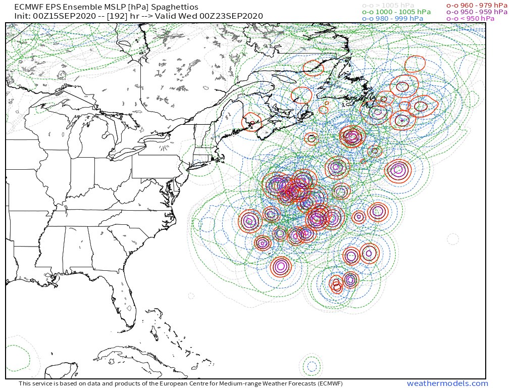
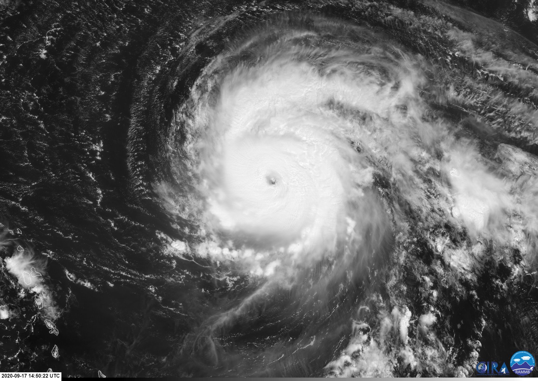
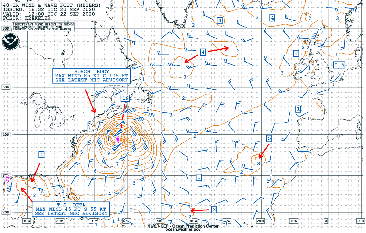
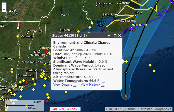
5:00 PM AST Thu Sep 17 | Location: 20.1°N 54.1°W | Moving: NW at 13 mph | Min pressure: 945 mb | Max sustained: 140 mph
Avatar
Glen Heinz (Greenville, SC) 16-Sep-20 12:46 AM
Avatar
Jacob Melton (Owosso, MI) 16-Sep-20 12:47 AM
Bermuda:
Avatar
Glen Heinz (Greenville, SC) 16-Sep-20 12:48 AM
yep
Avatar
Nate O. (DFW - Wylie, Texas) 16-Sep-20 01:06 AM
Such a tiny island seemingly in the middle of the ocean and about to get hit by 2 hurricanes in 2 weeks. Oof
Avatar
Jacob Melton (Owosso, MI) 16-Sep-20 02:11 AM
NHC issues Tropical Cyclone Update (TCU) at Sep 16, 10:10 AM AST ...TEDDY BECOMES A HURRICANE... https://t.co/kL9rY8fp89
85 MPH
Avatar
Alex V (Wausau, WI) 16-Sep-20 02:30 AM
That escalated quickly.
Teddy about to become an ACE machine?
Avatar
Zachary S (Jasper, AL) 16-Sep-20 02:37 AM
Three simultaneous canes now
Avatar
Pat Kepka (Russell Co. KS) 16-Sep-20 02:48 AM
Hurricane #Teddy Advisory 15: Teddy Rapidly Intensifies Into a 90-Mph Hurricane. https://t.co/VqHn0u1vgc
Teddy now 90 mph. And has RI’d
Avatar
Alex V (Wausau, WI) 16-Sep-20 02:49 AM
ACEmaker on the way
Avatar
Pat Kepka (Russell Co. KS) 16-Sep-20 03:39 AM
Bermuda, Atlantic Canada, & New England have to keep a weary eye on hurricane #Teddy. Not exactly an ideal trend over the last 3 Euro ensemble suites. https://t.co/shiWR4mE2r
Avatar
Pat Kepka (Russell Co. KS) 16-Sep-20 04:38 AM
Teddy now a category 2
Avatar
Ethan T. (Notasulga, AL) 16-Sep-20 05:10 AM
Close to 967mb
Avatar
Joey Prom (Lafayette, IN) 16-Sep-20 10:43 AM
Teddy forcast to become Cat 4 by ~36 hours. Well, there goes our slightly above average ACE total. Time to make a push for that hyperactive season! Go Teddy Go! Just stay over water while youa re doing it!
Avatar
Hunter Hollman (York, PA) 16-Sep-20 10:44 AM
Models showing him curving out to sea.. after hitting Bermuda of course
🤦‍♂️ 4
It'd be the perfect fish storm if it wasn't on a collision course with Bermuda
Avatar
Parker Hughes (McKinney, Tx) 16-Sep-20 01:57 PM
NOAA Dropsonde mission around Teddy right now
Avatar
Parker Hughes (McKinney, Tx) 16-Sep-20 02:54 PM
This 3 run trend of the ECMWF for #Teddy at day 5 is bad news bears. https://t.co/RTH6D82X6W
Avatar
Blaine K. (Pocatello, ID) 16-Sep-20 03:16 PM
Bermuda, Atlantic Canada, & New England have to keep a weary eye on hurricane #Teddy. Not exactly an ideal trend over the last 3 Euro ensemble suites. https://t.co/shiWR4mE2r
ECMWF ensembles aren't looking great either
Avatar
Alex V (Wausau, WI) 16-Sep-20 03:54 PM
Teddy looking big but not so cuddly
Avatar
Joey Prom (Lafayette, IN) 16-Sep-20 04:04 PM
Teddy is the name of my storm chasing Civic, lol. His theme song is Little Richards: "Ready Teddy"
Avatar
Royce Sheibal (Papillion,NE) 16-Sep-20 04:22 PM
"the euro nailed sandy" lol
Avatar
Royce Sheibal (Papillion,NE) 16-Sep-20 05:20 PM
EURO pulling a 'sandy teddy'
Avatar
Alex V (Wausau, WI) 16-Sep-20 05:21 PM
Has it merging with a trough too, likely going for a Sandy/Perfect Storm hybrid cyclone as well.
Avatar
Sasha (Montreal, QC)🇨🇦 16-Sep-20 05:22 PM
Oh my... That one track with a TS strength low passing over me 👀
Avatar
Royce Sheibal (Papillion,NE) 16-Sep-20 05:24 PM
TEDDY SANDY FUJIWHARA BOSTON CREAM PIE
thats euro ens. 1. reforms sally, does a fujiwhara, then teddy pulls a sandy and slams into boston FROM THE NORTHEAST
Avatar
Alex V (Wausau, WI) 16-Sep-20 05:25 PM
This run in a nutshell: Teddy: "Sally could you give me a lift?"
Avatar
Royce Sheibal (Papillion,NE) 16-Sep-20 05:25 PM
prepare for some really really weird models out of this one
you thought sally was bad to forecast? prepare for trying to forecast a potential sandy
Avatar
Avatar
Alex V (Wausau, WI) 16-Sep-20 05:26 PM
It could hit anywhere between NC and Newfoundland, or go OTS.
Avatar
Royce Sheibal (Papillion,NE) 16-Sep-20 05:28 PM
jesus, like 75% of the runs reform sally and do a fujiwhara /w teddy
many of them just stall teddy afterward, but lots of these runs have new england / NS landfall
who's ready for a potential cat 4 landfall in maine? meanwhile almost every run ALSO has a cat 1 landfall in S texas
yeah, these runs are nightmare mode. let's hope the next run isn't so scary
GOING DUE WEST? WHAT? NAH
this is only 6-7 days out folks. we start getting accurate runs around day 5. if this keeps up for another 4 runs, no bueno (edited)
Avatar
Zachary S (Jasper, AL) 16-Sep-20 05:36 PM
Question in the short term is, does he makes category three with the impinging shear and dry air intrusions
Avatar
Royce Sheibal (Papillion,NE) 16-Sep-20 05:38 PM
i think there is only one solution here. we must kill the teddy bear
Avatar
Sasha (Montreal, QC)🇨🇦 16-Sep-20 05:56 PM
2020, sounds like the year where New England would get a surprise major hurricane
Avatar
Ethan T. (Notasulga, AL) 16-Sep-20 06:03 PM
2020, where we repeat the 1938 New England Hurricane
Avatar
Alex V (Wausau, WI) 16-Sep-20 06:15 PM
What makes hurricanes in NE dangerous is that they tend to be undergoing extratropical transition as they head through there and their windfield gets huuuuuuuuuuuuuuuuuuuuuge, Sandy and '38 are only a couple examples.
Irene was feeling the effects of transition as it was going through there, as was Isais. Though Sandy and 38 were particularly devastating because the path they took brought all the surge ashore as they were transitioning. (edited)
Avatar
Royce Sheibal (Papillion,NE) 16-Sep-20 06:38 PM
keep in mind, this could be a sub 940 storm, POST merge /w a sally fujiwhara. the wind field will be perfect-storm sized if this occurs
there are 50 euro ensembesl and about 10 had what i'd call 'worst case scenario in a sci-fi movie' occuring
cross those fingers, people. 2020 does not forgive
this 1
Avatar
Jaden L. (Topeka, KS) 16-Sep-20 07:25 PM
goodness
Avatar
Sasha (Montreal, QC)🇨🇦 16-Sep-20 07:37 PM
Starting to watch this closer, considering how large the wind fields usually are and how close some of the ensemble members put the systems to me
Avatar
Jaden L. (Topeka, KS) 16-Sep-20 07:38 PM
I wouldn't imagine the environment farther north being as supportive for a stronger storm, well hopefully not like Isaias
Avatar
Glen Heinz (Greenville, SC) 16-Sep-20 07:39 PM
Tropical Drama.
Avatar
Ethan T. (Notasulga, AL) 16-Sep-20 09:04 PM
This is the deepest convection I've seen from a MDR TC (edited)
Avatar
Hunter Hollman (York, PA) 16-Sep-20 09:23 PM
Jeez, that's straight outta WPAC
Avatar
Pat Kepka (Russell Co. KS) 16-Sep-20 09:24 PM
Best track actually decreases wind speeds to 80 knots
Definitely looked better last night, but this new convection might boost it.
Avatar
Ian J. (Palm Beach County, FL) 16-Sep-20 09:26 PM
Seems like the anvils from that deep convection are just overtopping the eye
Was less convectively active last night
Avatar
Pat Kepka (Russell Co. KS) 16-Sep-20 09:27 PM
Wonder if the eye has closed back up.
Avatar
Ian J. (Palm Beach County, FL) 16-Sep-20 09:27 PM
Avatar
Zachary S (Jasper, AL) 16-Sep-20 09:43 PM
That's some cold tops there
Avatar
Pat Kepka (Russell Co. KS) 16-Sep-20 09:56 PM
Doesn’t look like it’s completely recovered yet. But impressive banding to the north.
Avatar
Zachary S (Jasper, AL) 17-Sep-20 03:09 AM
ADT going nuts, obviously
Avatar
Alex V (Wausau, WI) 17-Sep-20 03:16 AM
CI# /Pressure/ Vmax 4.5 / 974.1mb/ 77.0kt
ADT seems to be lagging.
Avatar
Garrett (Hillsdale MI) 17-Sep-20 04:02 AM
NHC is going with ADT
Avatar
Alex V (Wausau, WI) 17-Sep-20 06:54 AM
Latest ADT is pure insanity.
Avatar
Max (Saint John, NB) 17-Sep-20 08:31 AM
Okay getting worried
Euro, gfs, and gem all have teddy making landfall near meor just barely missing me
Avatar
Royce Sheibal (Papillion,NE) 17-Sep-20 08:51 AM
Landfall between NB and maine seems most likely at this point. Sti a long way off but watch out
Euro moved a little further east this run toward NS. Good for us bad for them
Avatar
Royce Sheibal (Papillion,NE) 17-Sep-20 09:04 AM
CI# /Pressure/ Vmax 5.6 / 952.3mb/104.6kt Final T# Adj T# Raw T# 5.6 6.2 6.5
Avatar
Max (Saint John, NB) 17-Sep-20 09:08 AM
Still very bad for me
Avatar
Glen Heinz (Greenville, SC) 17-Sep-20 09:09 AM
Eye is 33% covered. Lowest I could find on it. (edited)
Lets do this all 3 of them Vis/InFr/WV
Avatar
Royce Sheibal (Papillion,NE) 17-Sep-20 09:30 AM
there is a massive trough /w dry air to the west. that's what's goofing teddy up right now (edited)
if not for that he'd already be high end 4/low 5
Avatar
Royce Sheibal (Papillion,NE) 17-Sep-20 11:17 AM
95kts, 965. ouch
nope 105 kts , 957
Avatar
Parker Hughes (McKinney, Tx) 17-Sep-20 11:18 AM
Hurricane Hunters now entering powerful Major Hurricane #Teddy with its well-defined eye and intense eyewall thunderstorms
Avatar
Hunter Hollman (York, PA) 17-Sep-20 11:23 AM
Wow, so he's already Cat 3?
Avatar
Royce Sheibal (Papillion,NE) 17-Sep-20 11:42 AM
and growing
Avatar
Matthew Harding (Wichita, KS) 17-Sep-20 11:57 AM
Recon finding 120 kt flight level winds in NE eyewall of Teddy
Avatar
Avatar
Joey Prom (Lafayette, IN) 17-Sep-20 12:14 PM
Where do yall go to get zoomed in GOES images of Teddy? COD does not extend that far out into the atlantic
Avatar
Glen Heinz (Greenville, SC) 17-Sep-20 12:19 PM
I gets mines from GRearth which is GOES17 i think? lol (edited)
Avatar
Ian J. (Palm Beach County, FL) 17-Sep-20 12:20 PM
Joey you can see Teddy on COD through the meso sectors
👍 2
Avatar
Joey Prom (Lafayette, IN) 17-Sep-20 12:21 PM
Beast of a storm
Avatar
Joey Prom (Lafayette, IN) 17-Sep-20 12:28 PM
Looks like he has some dry air entrainment though.
Avatar
Ian J. (Palm Beach County, FL) 17-Sep-20 12:32 PM
doesn't look like a problem
Avatar
Royce Sheibal (Papillion,NE) 17-Sep-20 12:32 PM
CI# /Pressure/ Vmax 6.4 / 934.4mb/124.6kt Final T# Adj T# Raw T# 6.4 6.2 6.2
will take time for the winds to catch up with ADT. but this is likely a cat 4 by tonight
Avatar
Zachary S (Jasper, AL) 17-Sep-20 12:35 PM
Only the second major of season but quite a vigorous one
Avatar
Pat Kepka (Russell Co. KS) 17-Sep-20 12:48 PM
Teddy has a 40 n mile (46 miles) wide eye. (edited)
👀 4
Avatar
Joey Prom (Lafayette, IN) 17-Sep-20 12:49 PM
WPAC anyone?
On IR it looks like he is about to fully close off the eye from the dry air. I could be interpreting that wrong, but it looks like its about to be major go time!
Avatar
Pat Kepka (Russell Co. KS) 17-Sep-20 12:52 PM
Eye is already closed per recon
117 knots Flight level and 97 knot SFMR this pass
Avatar
Pat Kepka (Russell Co. KS) 17-Sep-20 02:32 PM
110 knots SFMR with Teddy
Avatar
Matthew Harding (Wichita, KS) 17-Sep-20 02:33 PM
High-end Cat 3.
OOF 3
Avatar
Zachary S (Jasper, AL) 17-Sep-20 02:43 PM
Extrapolated pressure still dropping
Avatar
Pat Kepka (Russell Co. KS) 17-Sep-20 02:44 PM
946.9 mb extrap at 29 knots (edited)
Avatar
Eric (Montreal, QC)🇨🇦 17-Sep-20 04:45 PM
forecasts expect it to reach an high end cat 4
Avatar
Garrett (Hillsdale MI) 17-Sep-20 04:46 PM
Really our best hope is for an EWRC before it hits Bermuda
Avatar
Royce Sheibal (Papillion,NE) 17-Sep-20 04:48 PM
there is A LOT of shear just NW of it with that trough
that will be the only thing stopping hit form hitting cat 5, imo. the water is fine
Avatar
Pat Kepka (Russell Co. KS) 17-Sep-20 04:48 PM
Also have Paulette’s wake ahead of it
27C-28C waters hard to support cat. 5s (edited)
Avatar
Royce Sheibal (Papillion,NE) 17-Sep-20 04:49 PM
she's got 50-75 OHC for another 36-48 hours. plenty to sustain cat 4 with slow growth, low end cat 5.
or should i say, he?
Avatar
Pat Kepka (Russell Co. KS) 17-Sep-20 04:50 PM
Yeah, more referring to when it nears Bermuda
Avatar
Royce Sheibal (Papillion,NE) 17-Sep-20 04:50 PM
yeah there will be 24-48 hours of weakening before berm hopefully
Avatar
Pat Kepka (Russell Co. KS) 17-Sep-20 04:54 PM
Just got a 114 knot SFMR in recon with 130 knot Flight level
category4 7
In the NW quad.
Advisory in. Teddy now 140 mph category 4.
Forecast to be 150 mph
Avatar
Matthew Harding (Wichita, KS) 17-Sep-20 04:58 PM
Wow
Avatar
Royce Sheibal (Papillion,NE) 17-Sep-20 05:01 PM
based on the satellite presentation, the cloud temps, this looks like it should be a top end cat 4 / low cat 5 within 24 hours
Avatar
Hunter Hollman (York, PA) 17-Sep-20 05:02 PM
Hurricane #Teddy Advisory 22: Teddy Strengthens to a Powerful Category Four Hurricane. Large Swells Forecast to Spread Across Much of the Western Atlantic Into This Weekend Increasing Rip Current Threat. https://t.co/VqHn0u1vgc
Avatar
Royce Sheibal (Papillion,NE) 17-Sep-20 05:02 PM
black ring of death is giving way to white ring of death, with lots of pink
Avatar
Hunter Hollman (York, PA) 17-Sep-20 05:02 PM
We could wake up to a Cat 5 tomorrow if ol' Ted keeps this up
Avatar
Zachary S (Jasper, AL) 17-Sep-20 05:03 PM
Teddy tryna make up for some of the weaker storms this year clearly
Avatar
Sasha (Montreal, QC)🇨🇦 17-Sep-20 05:37 PM
Avatar
Zachary S (Jasper, AL) 17-Sep-20 05:44 PM
Not ideal for Nova Scotia and Newfoundland
Avatar
Eric (Montreal, QC)🇨🇦 17-Sep-20 05:52 PM
140mph, cat 4 (edited)
We could technically wake up to see a 160mph Teddy tmr if it doesn't undergo eyewall replacement
Avatar
Max (Saint John, NB) 17-Sep-20 06:07 PM
Omg wtf
I'm nervous
In new brunswick can see nova scotia from my window
Avatar
Matthew Harding (Wichita, KS) 17-Sep-20 06:10 PM
That’s better than seeing Russia from your back yard.
Avatar
Max (Saint John, NB) 17-Sep-20 06:11 PM
Good point
Avatar
TJ (Houston/Galveston TX) 17-Sep-20 06:32 PM
prepare
Avatar
B. Dean Berry (Pittsburgh PA) ✱ 17-Sep-20 07:23 PM
Everyone gets a cane!
this 1
Avatar
Royce Sheibal (Papillion,NE) 17-Sep-20 07:47 PM
I told y'all two more landfall next week. But will it be Canadian instead of just american
Avatar
Pat Kepka (Russell Co. KS) 17-Sep-20 09:49 PM
30+ buoys were dropped within the black circle out in front of Teddy. Should be interesting to see what data they bring in tomorrow as the storm passes overhead.
Avatar
Zach E (Lakeville, MN) 17-Sep-20 10:00 PM
National Data Buoy Center - Recent observations from buoy 41044 (21.582N 58.630W) - NE ST MARTIN - 330 NM NE St Martin Is.
Avatar
Alex V (Wausau, WI) 17-Sep-20 10:36 PM
CI# /Pressure/ Vmax 6.7 / 926.9mb/132.2kt
Avatar
Royce Sheibal (Papillion,NE) 17-Sep-20 10:36 PM
16 ft wAves as 269nm
Avatar
Alex V (Wausau, WI) 17-Sep-20 10:36 PM
ADT is going insane
It would be nice if IR didn't keep glitching out though
Avatar
Pat Kepka (Russell Co. KS) 17-Sep-20 10:38 PM
Recon confirms that it’s over estimated.
Probably still around 120 knots
Avatar
Royce Sheibal (Papillion,NE) 17-Sep-20 10:41 PM
Looks like it took a breather this afternoon. New convection firing
Westerly jog suddenly. Eye is wobbly (edited)
Avatar
Matthew Harding (Wichita, KS) 17-Sep-20 10:43 PM
EWRC?
Avatar
Pat Kepka (Russell Co. KS) 17-Sep-20 10:44 PM
Probably not based on recon. 2 passes and really no double wind maxima on FL or SFMR except on the outbound of the last pass for FL
But the SFMRs didn’t double peak with it so might be attributable to something else
Avatar
Ian J. (Palm Beach County, FL) 17-Sep-20 10:46 PM
Considering how much the south eyewall has struggled I doubt an ERC any time soon
Avatar
Garrett (Hillsdale MI) 17-Sep-20 10:57 PM
Kinda amusing how ADT was way under yesterday now it's way over today (edited)
Avatar
Royce Sheibal (Papillion,NE) 17-Sep-20 11:31 PM
A little to the left. And one double cyclone fujiwhara cuz of a reformed sally
Avatar
Eric (Montreal, QC)🇨🇦 18-Sep-20 07:10 AM
130mph
Avatar
Max (Saint John, NB) 18-Sep-20 09:01 AM
How i get smacked
I'm. At the red dot
Avatar
Royce Sheibal (Papillion,NE) 18-Sep-20 09:29 AM
GFS has you on the left edge. EURO has you dead center. euro is known to perform well with east coast storms, so definately worth a watch
this thing could be so huge that even a near-miss will be bad
Avatar
Max (Saint John, NB) 18-Sep-20 09:30 AM
Pretty damn nervous watching this
Euro had me getting eyewalled yesterday
GFS had me getting feeder band hell zoned
Avatar
Royce Sheibal (Papillion,NE) 18-Sep-20 09:31 AM
based on wind flow, you might actually get reserve surge, and the water will flow OUT of the bay
but only after its close, the initial surge could be pretty big, along with 20+ foot waves
Avatar
Max (Saint John, NB) 18-Sep-20 09:34 AM
if water flows out of the bay, then thats going to be BAD
tide already gets super close to flooding everything when it isnt even windy
if that all flies right back in then uptown is prob gonna go underwater
Avatar
Royce Sheibal (Papillion,NE) 18-Sep-20 09:41 AM
i know in the past st johns has had some really wicked storms. like pre-ww2
might be a good time to look up some history
Avatar
Max (Saint John, NB) 18-Sep-20 10:05 AM
st johns and saint john have both gotten smacked very hard before
st johns can handle it because they have the infastructure, however saint john does not
we get pretty significant damage from every little weak storm that comes thru
Avatar
Eric (Montreal, QC)🇨🇦 18-Sep-20 10:06 AM
Euro has you get eyewalled
with 90kph winds jesus
GFS has it missing oyu
Avatar
Royce Sheibal (Papillion,NE) 18-Sep-20 01:29 PM
looking like odds of a US landfall with teddy are <20%. a handfull of the ensembles see it happening but not alot
odds of NS landfall near 100% at this point. even if it hits the US. it will stall and come back in for a double tap
unfortanely we're close enough in the forecast range that the margin of error is smaller than the province of NS.
landfalling pressure between 945-960 is a dangerous range. storm could be huge. lets hope that the anomolously warm waters off the coast don't let it support those pressures
Avatar
JoshuaClark 18-Sep-20 03:00 PM
GFS has you on the left edge. EURO has you dead center. euro is known to perform well with east coast storms, so definately worth a watch
@Royce Sheibal (Papillion,NE) The Euro is the bee's knees when it comes to tropicals.
Avatar
JoshuaClark 18-Sep-20 03:26 PM
Has anyone looked long term, as in a week from this Sunday. The GFS has a cyclone forming in the Western Caribbean, tracking north, with an eventual landfall in Southeast Florida?
Wrong Thread.
Avatar
Alex V (Wausau, WI) 18-Sep-20 04:39 PM
Water temperature will mean less because it is going to be going extratropical by then.
It may be fully extratropical by then, actually.
Which means the windfield is gonna get big.
Avatar
Jacob Melton (Owosso, MI) 18-Sep-20 10:58 PM
Back to category4
Avatar
Nate O. (DFW - Wylie, Texas) 18-Sep-20 11:03 PM
Does it still contribute to ACE when it goes subtropical?
Avatar
Pat Kepka (Russell Co. KS) 18-Sep-20 11:04 PM
You mean post-tropical? The answer is no if you mean that.
Avatar
Nate O. (DFW - Wylie, Texas) 18-Sep-20 11:06 PM
Yes, sorry
Thanks
Avatar
Alex V (Wausau, WI) 19-Sep-20 12:23 AM
New hot tower.
Avatar
Ian J. (Palm Beach County, FL) 19-Sep-20 11:08 AM
ERC, massive eye incoming
Avatar
Hunter Hollman (York, PA) 19-Sep-20 11:09 AM
Kinda reminds me of Dorian's ERC
Avatar
Eric (Montreal, QC)🇨🇦 19-Sep-20 01:53 PM
category3
120mph winds
Avatar
Avatar
Jim Martin (Findlay, Ohio) 19-Sep-20 06:12 PM
burst of convection inside the eye...
Avatar
Alex V (Wausau, WI) 19-Sep-20 08:00 PM
No, this isn’t the WPAC, yes, this is Teddy
Avatar
Jim Martin (Findlay, Ohio) 19-Sep-20 09:28 PM
Seems like the structure on Teddy is not as great as earlier.
Avatar
Jim Martin (Findlay, Ohio) 19-Sep-20 10:37 PM
I do not think Teddy is a major hurricane anymore
max surface wind from recon of 84 knots at roughly 10 PM
Not the same Teddy as we saw 48-72 hours ago.
Avatar
Jim Martin (Findlay, Ohio) 19-Sep-20 10:56 PM
Avatar
Pat Kepka (Russell Co. KS) 19-Sep-20 11:38 PM
Looks like Teddy is hitting Paulette’s wake, NNW side is just collapsing all around
Avatar
Ethan T [FBI] (Odessa, DE) 20-Sep-20 04:20 AM
Avatar
Pat Kepka (Russell Co. KS) 20-Sep-20 09:41 AM
Teddy really veering off course currently
Avatar
Eric (Montreal, QC)🇨🇦 20-Sep-20 10:02 AM
Teddy is no longer a major, 105mph
Avatar
Ethan T [FBI] (Odessa, DE) 20-Sep-20 10:13 AM
Avatar
Royce Sheibal (Papillion,NE) 20-Sep-20 12:32 PM
Teddy is getting a cold. A case of the cold water blues. But this isn't all good news
A stronger and taller storm would have a larger pull on it due to both shear and coriolis force. Because the storm is shorter and stunted (east to west stretched) it will turn right less
This could help explain the westward wobble and path deviation.
Avatar
Sasha (Montreal, QC)🇨🇦 20-Sep-20 02:17 PM
TS Watches issued for portions of the Nova Scotia coastline
Avatar
Joey Prom (Lafayette, IN) 20-Sep-20 04:32 PM
How did Teddy do in getting us ACE points?
Avatar
Garrett (Hillsdale MI) 20-Sep-20 04:39 PM
It aced it
Yao 4
Avatar
Pat Kepka (Russell Co. KS) 20-Sep-20 04:58 PM
In many respects, the upcoming trough interaction reminds me of an extratropical transition like Sandy 2012, thankfully happening at a good distance from land, with the GFS/ECMWF models showing pressures into the 940s tomorrow, a slight increase in maximum winds, and a large increase in the size of the tropical-storm-force winds.
Nhc just compared Teddy to sandy
Avatar
Hunter Hollman (York, PA) 20-Sep-20 07:01 PM
Hurricane #Teddy will build phenomenal seas across portions of the western #Atlantic over the next several days. Seas to 19 meters (62 ft.) expected by Tue will pose extreme danger to mariners. Mariners should take measures to avoid the area!
62 feet waves Hank
Avatar
Alex V (Wausau, WI) 21-Sep-20 02:40 PM
Transition process looks to be beginning.
Avatar
JoshuaClark 21-Sep-20 04:43 PM
We have 8-12ft surf on the northeast Florida coast and a coastal flood warning for the St. Johns River. The high winds knocked out our power here on base (Mayport NS) today. Near gale.
Avatar
Alex V (Wausau, WI) 21-Sep-20 05:13 PM
Though it's not Teddy it's the front he's merging with bringing those winds to FL.
Avatar
Pat Kepka (Russell Co. KS) 21-Sep-20 08:30 PM
One of the biggest 100 knot FL wind fields I’ve ever seen
Avatar
Glen Heinz (Greenville, SC) 22-Sep-20 09:29 AM
@Austin | (Grand Forks, ND) Posted this in Lobby and wow it's a dozer. (edited)
Avatar
Royce Sheibal (Papillion,NE) 22-Sep-20 09:30 AM
the ring of fire from the trough to the SW is pretty amazing
that trough might wash out and make it's own storm potentially
Avatar
Pat Kepka (Russell Co. KS) 22-Sep-20 09:38 AM
Recon is in Teddy now. Got 945.3 mb extrap in it
70 knot SFMRs on the SW side
Avatar
Zachary S (Jasper, AL) 22-Sep-20 09:56 AM
That's indeed as deep as models were hinting, wow
Avatar
Joey Prom (Lafayette, IN) 22-Sep-20 10:40 AM
Its not going extratropical till late. I am guessing that is bad news for Canada
Avatar
Max (Saint John, NB) 22-Sep-20 11:12 AM
Windy as fuck here
Avatar
Royce Sheibal (Papillion,NE) 22-Sep-20 11:22 AM
definately has some 'perfect storm' qualities to it
Avatar
Max (Saint John, NB) 22-Sep-20 11:24 AM
Teddy is eating beta and some other extratropical cyclone is trying to eat teddy lol
Avatar
Royce Sheibal (Papillion,NE) 22-Sep-20 11:29 AM
turtles all the way down
Avatar
Pat Kepka (Russell Co. KS) 22-Sep-20 02:22 PM
40 foot wave
Avatar
Joey Prom (Lafayette, IN) 22-Sep-20 03:13 PM
It would appear that Teddy is transitioning at the worst possible time, right as it comes ashore.
Avatar
JoshuaClark 22-Sep-20 03:32 PM
@Max (Saint John, NB) Do be safe. Humor my ignorance but what is the probable impacts to NS, NB, and Newfoundland from storm surge?
Avatar
Alex V (Wausau, WI) 22-Sep-20 03:48 PM
Nantucket and Cape Cod are getting TS-force winds.
Winds gusting 30-40 knots across parts of Nova Scotia.
Avatar
Sasha (Montreal, QC)🇨🇦 22-Sep-20 04:45 PM
Seas now up to 40 ft at buoy 44150, just north of #Hurricane #Teddy!
Avatar
Royce Sheibal (Papillion,NE) 22-Sep-20 04:57 PM
teddy is a freaking beast. on par with some of the largest tropical systems ever. almost as big as olga
Avatar
Ethan T. (Notasulga, AL) 22-Sep-20 05:30 PM
1700 UTC showed that the system still had a low-level eye feature. For that reason and for simplicity's sake, the system will remain a hurricane on this advisory, although it is obviously a hybrid low with many characteristics of a non-tropical cyclone.
Avatar
Royce Sheibal (Papillion,NE) 22-Sep-20 05:34 PM
"GINORMOUS"
Avatar
JoshuaClark 22-Sep-20 06:11 PM
She's a bonny and a joy for everyone.
"Teddy is a very impressive cyclone on satellite images this afternoon, even from full-disk images. The hurricane's circulation is over 1000 miles wide, with an enormous distinct comma shape and frontal features especially in the eastern semicircle." (edited)
Teddy is an incredible system.
Check this out. Impressive, very impressive. Looking at the last few frames of the loop, it still has convection firing around the core circulation. Very impressive indeed.
Avatar
Joey Prom (Lafayette, IN) 22-Sep-20 06:23 PM
Steady Teddy
Avatar
JoshuaClark 22-Sep-20 06:31 PM
Nova Scotia is in for a beating.
Avatar
Ian J. (Palm Beach County, FL) 22-Sep-20 06:50 PM
SFMR no higher than 60kt with only weakening expected from here on out - shouldn’t be too bad in terms of sustained winds
Avatar
Ethan T [FBI] (Odessa, DE) 22-Sep-20 07:43 PM
Teddy now an EXT
Avatar
Pat Kepka (Russell Co. KS) 22-Sep-20 07:47 PM
Post-Tropical Cyclone #Teddy Advisory 42A: Post-Tropical Cyclone Teddy Heading Toward the Nova Scotia Coast. Destructive Waves, Heavy Rain and Strong Winds Are Expected For Portions of Nova Scotia Tonight Through Wednesday. https://t.co/VqHn0u1vgc
Avatar
Max (Saint John, NB) 22-Sep-20 08:10 PM
@JoshuaClark pretty severe impacts happening here already
Avatar
B. Dean Berry (Pittsburgh PA) ✱ 22-Sep-20 09:47 PM
Whats it doing so far?
Avatar
Sasha (Montreal, QC)🇨🇦 22-Sep-20 11:37 PM
There's so much wrong here in terms of the warnings and watches in place.
Avatar
Ethan T. (Notasulga, AL) 22-Sep-20 11:38 PM
Don't know why ME isn't under a TS warning if their in the TS-force windfield
Same for New Brunswick
Avatar
Sasha (Montreal, QC)🇨🇦 22-Sep-20 11:39 PM
Same with New Brunswick, northern Nova Scotia, PEI
Not sure why they're only in a goddamn watch
Not to mention the hurricane force swath extends to the southwest Nova Scotia coast
Avatar
Ethan T. (Notasulga, AL) 22-Sep-20 11:40 PM
Heck, why is Nova Scotia not under a Hurricane watch or warning?
Avatar
Andy H. (Asheville, NC) 22-Sep-20 11:40 PM
Can't remember if storm surge is factored into those watches/warnings
Avatar
Ethan T. (Notasulga, AL) 22-Sep-20 11:40 PM
Since Teddy is sustaining itself at 70kts
Avatar
Andy H. (Asheville, NC) 22-Sep-20 11:40 PM
The wind field is expected to dissipate I guess, but clearly it's still large enough to where that is questionable
Avatar
Ethan T. (Notasulga, AL) 22-Sep-20 11:40 PM
Even if it's lower bound, you'll still receive hurricane force wind gusts
Avatar
Andy H. (Asheville, NC) 22-Sep-20 11:41 PM
The last advisory had an H in a white circle
Avatar
Sasha (Montreal, QC)🇨🇦 22-Sep-20 11:41 PM
Honestly, the most questionable part is northern Nova Scotia, and New Brunswick
Avatar
Andy H. (Asheville, NC) 22-Sep-20 11:41 PM
extratropical hurricane
Avatar
Sasha (Montreal, QC)🇨🇦 22-Sep-20 11:42 PM
Portions of New Brunswick and northern Nova Scotia/PEI are in the 90-100% TS force wind gust probabilities, as well as the ongoing current TS force wind radius, i'd assume that's enough for a tropical storm warning but idk lol
Avatar
Andy H. (Asheville, NC) 22-Sep-20 11:43 PM
Essentially, the NHC's main concern here is consistency in their outlook
since they are prioritizing public interaction and digestion of the info
Hence why Sandy was controversial, its hurricane status was "revoked" shortly before landfall
I assume all of this that would be inconsistent to us, who are used to what a forecast for this situation should look like, lines up much better with their previous discussions on impacts and the like (edited)
for the public
Avatar
Sasha (Montreal, QC)🇨🇦 22-Sep-20 11:44 PM
Indeed, it's clearly extratropical by now
It's a hurricane strength extra/post-tropical cyclone
Avatar
Ed Tierney (Des Plaines, IL) 22-Sep-20 11:46 PM
Reason why Maine isn't under a TS warning is probably because outside of gusty winds they aren't getting anything else from Teddy
There are wind advisories or high wind warnings that can cover that criteria, with TS warnings for the near shore waters
Avatar
Sasha (Montreal, QC)🇨🇦 22-Sep-20 11:47 PM
Yeah, that makes some sense at least, but northern Nova Scotia is confusing for me
In their own watch text they claim it'll reach sustained winds that meet the criteria for a TS warning, and mention other TS hazards along with it, but no warning
Avatar
Pat Kepka (Russell Co. KS) 22-Sep-20 11:48 PM
Environment Canada does all the TS warnings, watches, etc. not the nhc
Avatar
Sasha (Montreal, QC)🇨🇦 22-Sep-20 11:48 PM
Indeed
Avatar
Pat Kepka (Russell Co. KS) 22-Sep-20 11:48 PM
Nhc just relays it
Avatar
Andy H. (Asheville, NC) 22-Sep-20 11:48 PM
All they can do is be consistent then
Conventional clashing...
Avatar
Ed Tierney (Des Plaines, IL) 22-Sep-20 11:50 PM
Probably they are in the process of changing the guard on handling this system. Hence why NHC was PTC on the latest update
Avatar
Sasha (Montreal, QC)🇨🇦 22-Sep-20 11:52 PM
When coastal and/or coastal winds of 63 to 117 km/h caused by a tropical cyclone are expected to occur.
This is Tropical Storm Warning criteria for ECCC Here's the text from the TS Watch in place where no TS warning has been issued yet
Tropical storm watch in effect for: Pictou County Tropical storm force winds ahead of now Post-Tropical Storm Teddy are expected over the regions, but will remain just below wind warning criteria. Potential wind gusts: 65 to 80 km/h over exposed areas and along parts of the coast. Locations: The Annapolis Valley, northern Nova Scotia, and western Cape Breton.
Maybe it's not sustained enough?
Because they primarily mention wind gusts
Avatar
Sasha (Montreal, QC)🇨🇦 23-Sep-20 12:13 AM
It's their call, and they're degree mets and they know the area better than I do so eh
Avatar
Max (Saint John, NB) 23-Sep-20 07:16 AM
Btw weve been getting 70 kmh sustained for atleast 24h now
No ts watch even LOL
Not super gusty here its just sustained wind
Avatar
Max (Saint John, NB) 23-Sep-20 08:58 AM
My back door got smashed in
Avatar
Royce Sheibal (Papillion,NE) 23-Sep-20 01:10 PM
"TEDDY MAKES LANDFALL NEAR ECUM SECUM NOVA SCOTIA" Wow. that's a name.
Yao 9
Avatar
Max (Saint John, NB) 23-Sep-20 02:00 PM
Oh my. God I forgot about that place lmao
Avatar
Royce Sheibal (Papillion,NE) 23-Sep-20 02:12 PM
hey guys, what if we replaced the last 3 letters of our names with something silly, like Ecum Secum
Avatar
ModBot BOT 24-Sep-20 02:01 PM
Archived.
Exported 316 message(s)