Guild icon
Stormtrack
EVENT ARCHIVE / td-beta-2020
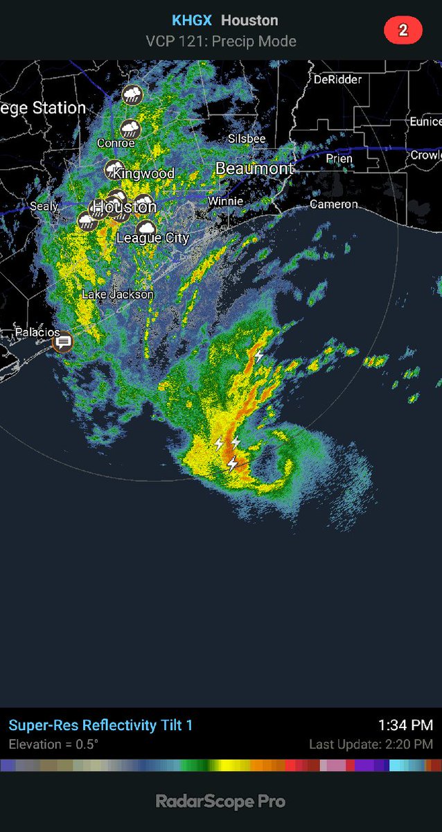
4:00 PM CDT Mon Sep 21 | Location: 28.2°N 96.1°W | Moving: NW at 5 mph | Min pressure: 999 mb | Max sustained: 45 mph
Avatar
Hunter Hollman (York, PA) 19-Sep-20 12:03 AM
@Jaden L. (Topeka, KS) Wish granted
👍 2
Avatar
Pat Kepka (Russell Co. KS) 19-Sep-20 12:05 AM
Avatar
Hunter Hollman (York, PA) 19-Sep-20 12:05 AM
Damn, I didn't realize how big that windfield is
another Big Chungus of a storm I suppose
Avatar
Alex V (Wausau, WI) 19-Sep-20 12:12 AM
Beta has been able to strengthen despite being affected by strong southwesterly shear. The shear could begin to relax over the next few days, particularly by day 2 and 3, which could allow for some further strengthening. The SHIPS guidance remains the most aggressive of the intensity models, and the NHC intensity forecast leans heavily toward those solutions given Beta's recent intensification trend (which SHIPS seemed to handle better)
Most foreboding part of the discussion
Avatar
Nate O. (DFW - Wylie, Texas) 19-Sep-20 12:25 AM
Ahhh. My parents in Corpus are asking for clear advice on what to do. I'm telling them likely about the impacts of Hanna for them, since they just missed the eyewall, but had a good bit of surge and everything else. I'm not confident with beta though.
Avatar
beard (fort worth) 19-Sep-20 12:28 AM
I've been asking for this all damn day
Avatar
B. Dean Berry (Pittsburgh PA) ✱ 19-Sep-20 12:29 AM
I just noticed it wasn't there
Wilfred just got one too
Avatar
beard (fort worth) 19-Sep-20 12:30 AM
😠
@Nate O. (DFW - Wylie, Texas). Pm me
Avatar
B. Dean Berry (Pittsburgh PA) ✱ 19-Sep-20 12:30 AM
I had to go to work, then did more renovations at home.
Avatar
Royce Sheibal (Papillion,NE) 19-Sep-20 12:38 AM
this is going to be an inland flooding storm, like harvey. but further south most likely
wind and surge will be secondary. euro and gfs booth like this for 20+ inches of rain on the coast
the two centers appear to be consolidating
there is a pretty nice central core forming on wv-ir and dvorak
Avatar
Alex V (Wausau, WI) 19-Sep-20 12:44 AM
Already?
Holy crap you are right.
Avatar
Garrett (Hillsdale MI) 19-Sep-20 12:44 AM
The fact it's doing that in this shear is yikes
Avatar
Royce Sheibal (Papillion,NE) 19-Sep-20 12:47 AM
we could have an eye by morning
Avatar
Alex V (Wausau, WI) 19-Sep-20 12:47 AM
The slight northeastern motion is likely negating some of the shear. Moving 10 KTS NNE. First 5 knots of shear likely don't matter.
Avatar
Royce Sheibal (Papillion,NE) 19-Sep-20 12:47 AM
its getting together that fast. i say could meaning <50% chance, but it will be a test
Avatar
Alex V (Wausau, WI) 19-Sep-20 12:49 AM
It is under 35 knots of SSW shear, moving ENE at 10 knots, so therefore the first 10 knots don't matter right now and relative shear is about 25 knots.
If it was moving more NNW the shear would be taking a bigger toll on it.
A big part of the intensity forecast discrepancy earlier was regarding if it would track NNE or NNW, it went NNE, the most shear-negating route.
Avatar
Sean H(Houghton,MI) 19-Sep-20 12:58 AM
Damn that Beta storm is drunk af.
Avatar
beard (fort worth) 19-Sep-20 01:04 AM
All shear goes poof sunday and it's fair game
The only thing i struggle with is steering winds lol i always get distracted.
Avatar
Royce Sheibal (Papillion,NE) 19-Sep-20 01:11 AM
steering winds are about 5-10 mph out of the NE
but shear is 25-30 out of the SW
so the storm is like YOLO?
Avatar
beard (fort worth) 19-Sep-20 01:25 AM
GFS and NAM agree on land fall in corpus. Waiting for Euro to get it's 00z together
Avatar
Ethan T. (Notasulga, AL) 19-Sep-20 01:26 AM
Okay, that's ALOT of lightning activity
Avatar
beard (fort worth) 19-Sep-20 01:27 AM
You and lightning lol
Avatar
Royce Sheibal (Papillion,NE) 19-Sep-20 01:27 AM
yes, that is a crazy amount of lightning
RI odds a bit concerning: 65kt / 72h 18.9% 17.4% 18.1%
not great odds but not horrible either.
SHIPs, which has done the best with this storm so far, says Hello Matrix of RI probabilities ------------------------------------------------------------------------------ RI (kt / h) | 20/12 | 25/24 | 30/24 | 35/24 | 40/24 | 45/36 | 55/48 |65/72 ------------------------------------------------------------------------------ SHIPS-RII: 23.2% 45.0% 28.1% 13.0% 11.5% 13.5% 35.2% 35.2%
1/3 chance of 115kts? no thanks
Avatar
beard (fort worth) 19-Sep-20 01:32 AM
Loop goes-16 it already is spinning like crazy. Never seen a ts do that.
Ok slow down with the met talk lol people come here to learn also.
Avatar
Ethan T. (Notasulga, AL) 19-Sep-20 01:35 AM
~45-50% chance at CAT1+
thonk
35% chance at 110-120kts?
Um, I'll pass......
Avatar
Royce Sheibal (Papillion,NE) 19-Sep-20 01:36 AM
ships is going bonkers with this storm, and its been right so far
last run was intitalized at 50kts. it ran 35% for +65 kts, or 115kts
notice the high end tail, it likes the storm to survive until monday over water then go nuts
it also likes it to be at 75kts by tomorrow 00z
Avatar
beard (fort worth) 19-Sep-20 01:37 AM
That area isn't built for those winds. Hanna was barely under a cat 2 and pulled stuff a part no problem.
Avatar
Royce Sheibal (Papillion,NE) 19-Sep-20 01:38 AM
its looking more like this could be hanna part 2. lets hope its' not harvey part 2
this 1
Avatar
Ethan T. (Notasulga, AL) 19-Sep-20 01:38 AM
Putting a 110-120kt system in that area would make it a "meat grinder"
Avatar
beard (fort worth) 19-Sep-20 01:38 AM
Hanna but 80 miles north.
Since i've never looked at a ships graph ever. What does that big ass jump between dots mean?
Avatar
Royce Sheibal (Papillion,NE) 19-Sep-20 01:40 AM
link/photo?
Avatar
beard (fort worth) 19-Sep-20 01:40 AM
The one you posted
Avatar
Royce Sheibal (Papillion,NE) 19-Sep-20 01:40 AM
oh thats not ships, thats a saffir simpson vs IKE scale
Avatar
beard (fort worth) 19-Sep-20 01:40 AM
Oh
Avatar
Royce Sheibal (Papillion,NE) 19-Sep-20 01:40 AM
comparing observed wind category vs damage category
Avatar
beard (fort worth) 19-Sep-20 01:41 AM
Never seen it before so i had to ask. I'm still learning with tropical. Been treating it like a giant meso and trying to learn on my own like i always do.
Avatar
Royce Sheibal (Papillion,NE) 19-Sep-20 01:42 AM
ships is a giant wall of text output. best intensity model around despite looking like its from the 80s
Avatar
beard (fort worth) 19-Sep-20 01:42 AM
Is it mostly % of what could be type output?
All that smooshed together in my mind lol
Avatar
Royce Sheibal (Papillion,NE) 19-Sep-20 01:44 AM
ships gives a lot of output. but the two main things are a forecast of wind speed every 6/12 hours, and then the odds of rapid intensification every 12/24 hours
so while ships says: landfall as a hurricane, low cat 1, it also tells us that it COULD get much stronger, and what those odds are
intensity forecasting is an even bigger nightmare than landfall location
Avatar
Bob (BTR, La) N5BZ Waze:bz2012 19-Sep-20 01:48 AM
Avatar
Royce Sheibal (Papillion,NE) 19-Sep-20 01:51 AM
spiral band of lightning forming in SE quad
Avatar
beard (fort worth) 19-Sep-20 01:51 AM
That's what i was talking about.
Avatar
Royce Sheibal (Papillion,NE) 19-Sep-20 01:52 AM
spiral bands are a dead giveaway that beta is getting much more organized. 60mph now. hurricane by tomorrow seems like good odds
Avatar
beard (fort worth) 19-Sep-20 01:53 AM
All with in the last hour
Just watching lightning tracker it shows it growing. More and more getting farther out from the main cluster.
1 strike on average every 1.8s
Avatar
Alex V (Wausau, WI) 19-Sep-20 08:13 AM
Beta actually intensified a little overnight, not by much though, it is still at 60 mph but pressure fell by a millibar.
40 knot SFMRs are also being found in the area with no convection.
Avatar
Alex V (Wausau, WI) 19-Sep-20 09:07 AM
55 knot max winds
It actually has gotten stronger.
62 knot winds at 981 mb. (edited)
Avatar
Pat Kepka (Russell Co. KS) 19-Sep-20 09:21 AM
Likely gusts. Nhc uses the mean 150 meter with an 85 % reduction for wind speeds
Avatar
Alex V (Wausau, WI) 19-Sep-20 09:21 AM
For a matter of perspective, this is the storm that strengthened overnight. Nearly naked swirl, convection displaced from the center, but regardless it gained knots and dropped millibars overnight, and mostly windy on the sheared side. This is a strengthening storm.
Avatar
Pat Kepka (Russell Co. KS) 19-Sep-20 09:22 AM
It dropped 1 mb over night.
Avatar
Alex V (Wausau, WI) 19-Sep-20 09:22 AM
And shows higher SFMRs and a TS windfield over a wider area.
And those sondes.
Avatar
Pat Kepka (Russell Co. KS) 19-Sep-20 09:23 AM
That sonde supports 50 knots yet
Imo, all that changed overnight is it consolidated to one center and max winds are now on the NW side
The consolidation is an improvement so yes
Avatar
Alex V (Wausau, WI) 19-Sep-20 09:24 AM
Nah, it intensified. And it is remarkable it is doing so well and managed to even drop one millibar under that shear. Intensification is intensification even if it is slight intensification.
Avatar
Pat Kepka (Russell Co. KS) 19-Sep-20 09:26 AM
Not sure how the dropsonde supports intensification. 60 knot gusts are common in 45-50 knot storms.
I guess 1 mb deepening can be a sign
Avatar
Alex V (Wausau, WI) 19-Sep-20 09:26 AM
The sonde was 55 knots. The 60 knot was elevated as I said.
Avatar
Pat Kepka (Russell Co. KS) 19-Sep-20 09:27 AM
That is not a sustained wind though
Dropsonde measure gusts most of the time
Avatar
Alex V (Wausau, WI) 19-Sep-20 09:27 AM
SFMRs pushing higher tell me otherwise.
Avatar
Pat Kepka (Russell Co. KS) 19-Sep-20 09:28 AM
51 knots SFMR is about on par with what it had last night
Avatar
Alex V (Wausau, WI) 19-Sep-20 09:30 AM
51-53 SFMRs with a 55 knot surface sonde supports 55 knots, now if it was 40-45 knots with a 55 knot sonde, then yeah it is probably a gust. (edited)
Anyways, even if it was a gust there is still the lowering pressure and the fact the storm is keeping it's strength under all the shear, which is impressive enough on it's own.
Another way you can tell if it is a gust is if it is significantly higher than in the air layers above it, the layers above it measured 60+ knot winds. The profile supports sustained.
Avatar
Pat Kepka (Russell Co. KS) 19-Sep-20 09:45 AM
You can look at them that way I guess but NHC uses a different methodology for determining sustained winds from dropsondes. It’s an 85% reduction from the mean lowest 150 meters
Which would be ~51-52 knots which matches SFMR
Avatar
Alex V (Wausau, WI) 19-Sep-20 09:48 AM
1 millibar, 10 millibar, 1 knot, 10 knots, either one is intensification. Beta also has a very warm core for it's structure according to the eye drop, again, the fact Beta is so strong with it's top blown off is impressive and should let us know the storm could really pop off once it stacks.
It could make a quick run to a mid Cat 1, and then slow roll from there due to dry air. (edited)
Avatar
Pat Kepka (Russell Co. KS) 19-Sep-20 09:53 AM
Its forecast to reach cat. 1 status late tonight so wouldn’t be surprised
Avatar
Alex V (Wausau, WI) 19-Sep-20 09:57 AM
Might be able to achieve mid Cat 2 or a little higher, depends on how well it can handle the dry air.
Avatar
beard (fort worth) 19-Sep-20 09:57 AM
Euro thinks it'll die tomorrow morning lol
Avatar
Alex V (Wausau, WI) 19-Sep-20 09:57 AM
Keep a close eye on how rapidly the core develops, if it closes off quickly dry air will have less of an impact on it later on.
@beard (fort worth) No it doesn't. It landfalls it into Texas as a 50-60 knot TS.
Granted this run didn't have the HH data
Avatar
Pat Kepka (Russell Co. KS) 19-Sep-20 10:04 AM
Beta should be starting it’s turn and slowing down here anytime.
Avatar
Matthew Harding (Wichita, KS) 19-Sep-20 10:19 AM
If a storm's pressure only fell by one millibar while we slept and no one was there to document it, did it actually strengthen?
Yao 6
Avatar
Avatar
Jeff House (Chattanooga, TN) 19-Sep-20 10:26 AM
The ECMWF is not really the tropical king anyway. Certainly not intensity. Better than the GFS is a low bar. Sandy track is just a running joke. Bless your heart. (edited)
Avatar
Joey Prom (Lafayette, IN) 19-Sep-20 10:32 AM
A running joke for GFS, or ECMWF?
Avatar
beard (fort worth) 19-Sep-20 10:33 AM
Keep trying.
This is one of those storms people will sleep on then it goes bat shit crazy at the last minute.
Avatar
Jeff House (Chattanooga, TN) 19-Sep-20 10:42 AM
I'm usually bearish tropics. Sally pattern recognition was obvious though.
Avatar
Alex V (Wausau, WI) 19-Sep-20 10:43 AM
So you are saying it will or it won't die, Beard? I am confused as to what you are getting at with this.
Avatar
Jeff House (Chattanooga, TN) 19-Sep-20 10:44 AM
So is he. Beta will fight dry air entrainment.
this 2
Avatar
beard (fort worth) 19-Sep-20 10:46 AM
It won't die. But models will try and kill it.
Avatar
Alex V (Wausau, WI) 19-Sep-20 10:48 AM
That is kinda what the models do when a storm has only recently developed into a TS.
Avatar
Jeff House (Chattanooga, TN) 19-Sep-20 10:49 AM
None of the reliable models kill it. What is he looking at? Smh
It'll survive but not thrive.
Avatar
beard (fort worth) 19-Sep-20 10:50 AM
I see you have selected your target. Best of luck.
Avatar
Jeff House (Chattanooga, TN) 19-Sep-20 10:54 AM
I'm just forecasting. Try it sometime.
Avatar
beard (fort worth) 19-Sep-20 10:56 AM
I forecast sunshine on my shoulders.
Avatar
Alex V (Wausau, WI) 19-Sep-20 11:11 AM
That intense convection popped up quickly.
Avatar
Alex V (Wausau, WI) 19-Sep-20 11:23 AM
The intense convection already pulled Beta's center underneath it. And lotsa lightning too.
Avatar
TJ (Houston/Galveston TX) 19-Sep-20 11:45 AM
Nam brings storm to San Antonio, likely ending the worst for Houston/Louisiana Yao
Avatar
beard (fort worth) 19-Sep-20 11:53 AM
You going to play tj?
Avatar
Royce Sheibal (Papillion,NE) 19-Sep-20 12:04 PM
Shear is down to about 25kts. Massive dry air wall to the west
Should balance out to be neutral conditions for the next 24 hours. If the storm can spread out and the shear lessens that wi help keep our the dry air later
There is still a mid level center with that blob to the east but it's getting too far away to matter at this point
Avatar
beard (fort worth) 19-Sep-20 12:09 PM
What the hell. Is it trying to become 2 seperate storms?
Avatar
Royce Sheibal (Papillion,NE) 19-Sep-20 12:12 PM
It tried that yesterday, but the west side won. Right side lost surface flow and now poof it will be gone
Avatar
beard (fort worth) 19-Sep-20 12:17 PM
More flooding rain for LA and eastward. That sucks.
Avatar
beard (fort worth) 19-Sep-20 12:32 PM
NHC just updated. Looks like they think it'll barely be a hurricane when it hits.
Avatar
Pat Kepka (Russell Co. KS) 19-Sep-20 12:33 PM
They noted no models show it getting to hurricane strength anymore.
They also shows this landfalling on Texas now in less than 72 hours.
Avatar
B. Dean Berry (Pittsburgh PA) ✱ 19-Sep-20 01:10 PM
Models turned skittish on a dime.
Avatar
Royce Sheibal (Papillion,NE) 19-Sep-20 01:28 PM
No west move yet. Still stalled trying to organize under the cdo
Avatar
Eric (Montreal, QC)🇨🇦 19-Sep-20 01:50 PM
so apparently Euro wants this thing to stall on top of Texas for a whole 2 days
Avatar
TJ (Houston/Galveston TX) 19-Sep-20 02:02 PM
Yeah, I'm playing this storm. Locally of course. Going to sit up on the levee, beach as long as I can.
Avatar
beard (fort worth) 19-Sep-20 02:14 PM
Nate says he may go down. I know aaron just left CO and is on his way.
Hey @Royce Sheibal (Papillion,NE). Message me real quick please.
Avatar
Pat Kepka (Russell Co. KS) 19-Sep-20 02:16 PM
12z euro actually takes beta way deeper into Texas, near San Antonio before it starts slowly moving east
Might be a remnant low in 96 h
Avatar
Royce Sheibal (Papillion,NE) 19-Sep-20 02:21 PM
Two definite scenario possible here. Shear keeps up and the storm stays weak, can't get very far west, recoils back east over water and makes a LA landfall. Other scenario, shear finally let's go and it jets west and hits cat 1 then turns extra tropical near SA
Avatar
beard (fort worth) 19-Sep-20 02:26 PM
The 2nd one is what i've been feeling like will happen since i started looking on monday.
A short lived cat 1 is way better than a long lived t.s. in my books.
Avatar
Royce Sheibal (Papillion,NE) 19-Sep-20 04:11 PM
Pressure down to 994. Good convection. Shear still an issue
Avatar
Ethan T. (Notasulga, AL) 19-Sep-20 04:11 PM
When is shear suppose to let up?
Avatar
Royce Sheibal (Papillion,NE) 19-Sep-20 04:23 PM
Was supposed to be today.
Shear is down to 20kts so it's neutral. If this survives until Monday it will drop to zero and be right under a high
Avatar
Pat Kepka (Russell Co. KS) 19-Sep-20 05:09 PM
Beta now stationary per nhc
Avatar
Matthew Harding (Wichita, KS) 19-Sep-20 05:09 PM
No longer expected to make landfall as a hurricane either
Avatar
Pat Kepka (Russell Co. KS) 19-Sep-20 05:11 PM
First, the global models still suggest that the ongoing southwesterly shear may not subside much before landfall. Second, GOES-16 air mass imagery shows abundant upper-level dry air over the western Gulf of Mexico, including near the storm center. Third, surface observations show a drier low-level airmass in place over southeastern Texas, and some of this may be getting entrained into the storm.
Looks like shear may not decrease anymore
Really only thing going for it is high OHC
Avatar
beard (fort worth) 19-Sep-20 05:22 PM
We pretty much knew it would weaking before land fall. The issue is it's moving so slow whatever it does make land fall is will still cause flooding etc. It's winds are reaching oretty far out.
Avatar
Alex V (Wausau, WI) 19-Sep-20 07:47 PM
Shear is letting up according to sat derived shear, not sure what the models were seeing but it is down to 15-20 knots directly over Beta right now.
Avatar
Pat Kepka (Russell Co. KS) 19-Sep-20 07:52 PM
Recon finds beta at 996mb extrap. Now waiting for a sonde
Avatar
Ian J. (Palm Beach County, FL) 19-Sep-20 07:54 PM
came in at 997, 4kt surface wind
slight weakening
Avatar
Alex V (Wausau, WI) 19-Sep-20 07:55 PM
Not surprised, convection went poof. Likely due to the effects of DMIN.
Avatar
Matthew Harding (Wichita, KS) 19-Sep-20 07:55 PM
Or dry air and shear.
this 1
Avatar
Ian J. (Palm Beach County, FL) 19-Sep-20 07:56 PM
yep
Avatar
Alex V (Wausau, WI) 19-Sep-20 07:57 PM
Shear is down to 15-20 knots right now and dry air is def an issue but it is also DMIN, we should see another big burst later on closer to DMAX. Dry air will probably make any convective organization overnight slow to occur.
Avatar
B. Dean Berry (Pittsburgh PA) ✱ 19-Sep-20 08:09 PM
Could we see this just sit in place and die?
Avatar
Pat Kepka (Russell Co. KS) 19-Sep-20 09:16 PM
Well beta continues to see a rise in pressure but winds are still around 50 knots
Avatar
beard (fort worth) 19-Sep-20 10:41 PM
See if it regains anything when the sun comes back up. Even at 50 knots that's a decent ts and tons of rain.
Avatar
Alex V (Wausau, WI) 19-Sep-20 10:53 PM
It probably will gain something because morning is maritime DMAX, question is will it be able to keep it.
It was looking great this morning before shear and dry air got to it.
Shear is relaxing so it might organize more but this isn't going to be an explosive Harvey-type landfall.
This will reach low-mid Cat 1 in the most bullish scenario.
My cast has become more bearish, I was thinking it could pop off and make a cat 2 run if it was able to use this morning to organize it's core but now a low Cat 1 is my top prediction, my prediction is most likely a 55-60 knot TS peak though. But it will weaken up to landfall. (edited)
this 2
Avatar
Jeff House (Chattanooga, TN) 19-Sep-20 10:57 PM
I'm bearish too. Meh.
Avatar
Pat Kepka (Russell Co. KS) 19-Sep-20 11:03 PM
NHC has the current 60 mph as its peak intensity now. (edited)
The air mass behind the old front appears to have won out. Beta's circulation is embedded in a dry environment of mid-level relative humidities around 50 percent, and the air mass could actually become more stable as Beta moves closer
Avatar
Alex V (Wausau, WI) 19-Sep-20 11:04 PM
Honestly
I wouldn't be surprised if it pulls a Marco and dies before landfall. (edited)
Low C1 is my absolute top prediction, 45-55 kt TS more likely, and my bottom margin is straight up just dies. (edited)
This is not a sleeper storm, it's just junk.
Avatar
Avatar
Jeff House (Chattanooga, TN) 19-Sep-20 11:21 PM
WPC also needs to reverse course on that QPF. Won't happen.
Avatar
Alex V (Wausau, WI) 19-Sep-20 11:22 PM
The only thing Beta is gonna do at this point is contribute to a dryline setup. (edited)
🤣 1
Avatar
Cameron (Fortson, GA) 19-Sep-20 11:25 PM
This storm is pretty ugly ngl
Avatar
Pat Kepka (Russell Co. KS) 19-Sep-20 11:28 PM
Probably going to slow roll the qpf down
Avatar
Royce Sheibal (Papillion,NE) 19-Sep-20 11:58 PM
holy jesus that is a lot of dry air
DRY A. P.
we've got saharan level dry air over texas right now. its nuts. mostly due to the smoke from cali. who'd have guessed. the new best source of the SAL would be hellfire
Was nice knowing you, beta.
Hey guys, i've got a great idea. instead of nuking hurricanes like trump suggested, let's kill them with massive wildfire smoke! that'll work for sure! no bad side effects.
this 2
Avatar
Alex V (Wausau, WI) 20-Sep-20 12:05 AM
Appears to be moreso coming out of the SW desert.
Avatar
Royce Sheibal (Papillion,NE) 20-Sep-20 12:06 AM
75% of the smoke from the fires had been blown out to sea over the last month. now that winds are back onshore it's coming back at us.
not great news for those of us in the midwest having the worst drought since....well ever. we're below dust-bowl rainfalls in omaha
Avatar
Cameron (Fortson, GA) 20-Sep-20 12:07 AM
dry
RH values are asthmatic
Avatar
Royce Sheibal (Papillion,NE) 20-Sep-20 12:10 AM
beta's struggle vs the dry air is so futile i just closed all my windows that had beta forecast windows open
Avatar
Alex V (Wausau, WI) 20-Sep-20 12:25 AM
Is this Beta's last gasp?
Avatar
Royce Sheibal (Papillion,NE) 20-Sep-20 12:33 AM
the intense lightning all this time was a signal that dry air was involved with convection. considering it's dying AF right now and still lightning, it's devolved into a dryline, basically
i been saying all season lightning ONLY happens in tropical systems due to 1 - DRY AIR, 2 - Rapid intensification
Avatar
Nate O. (DFW - Wylie, Texas) 20-Sep-20 12:41 AM
Regardless of what it does, it's already cussing havoc in areas directly on the coast. My parents live in a canal on Padre Island in corpus. Water levels ul about a foot from normal, and coming up steadily since last night. Beach erosion was horrible from Hanna and hadn't all been addressed, so this storm may not do too much directly, but it's causing problems
Avatar
beard (fort worth) 20-Sep-20 12:52 AM
NOT FOR BROADCAST Contact Brett Adair with Live Storms Media to license. [email protected] As Tropical Storm Beta slowly makes it's way towards the gulf coast, we get our first signs of it in Port Aransas.
This just popped up.
Avatar
Royce Sheibal (Papillion,NE) 20-Sep-20 10:25 AM
Still fighting 20+ kts of shear. Not going anywhere fast. Monday landfall might be Tues now and further north
Avatar
Pat Kepka (Russell Co. KS) 20-Sep-20 10:30 AM
61 knots flight level and a 59 knot SFMR
It’s well displaced to the NW of the center
Dropsonde in that max wind band finds lower winds (edited)
Avatar
Royce Sheibal (Papillion,NE) 20-Sep-20 10:46 AM
The only reason it's made it this long this strong is that it coupled with the old frontal boundary leftover post sally. Really tapping into those Dynamics and vorticity
Avatar
Pat Kepka (Russell Co. KS) 20-Sep-20 12:06 PM
Beta be like let’s move north instead of west
Avatar
Royce Sheibal (Papillion,NE) 20-Sep-20 12:30 PM
The more shear stays the slower and more north it will go. The more shear it will have...etc
Avatar
beard (fort worth) 20-Sep-20 01:14 PM
According to radar it just hooked left
Avatar
Pat Kepka (Russell Co. KS) 20-Sep-20 01:14 PM
It actually relocated it seems
Relocated under the convection, might see a short term strengthening
Avatar
Alex V (Wausau, WI) 20-Sep-20 01:26 PM
well then
Avatar
Royce Sheibal (Papillion,NE) 20-Sep-20 01:42 PM
There has been a meso boundary just W of beta for some time. The earlier convection was firing on it. Now it's following it, ripping southwest
Shear appears to be letting up as it makes this west or southwest move. Now is the time for it to make up ground
βœ… 1
Shear is 15 kts now over the center. Lots of lightning and dry air interaction.
Avatar
Pat Kepka (Russell Co. KS) 20-Sep-20 01:53 PM
Tropical Storm #Beta Advisory 12A: Reconnaissance Aircraft and Radar Data Indicate That Beta Has Redeveloped a Little Farther to the West. https://t.co/VqHn0u1vgc
Avatar
Alex V (Wausau, WI) 20-Sep-20 01:57 PM
A circular CDO of any strength in these conditions is impressive.
Avatar
Royce Sheibal (Papillion,NE) 20-Sep-20 01:59 PM
That's an eye boys
Avatar
Alex V (Wausau, WI) 20-Sep-20 01:59 PM
Whaaaaa?
Avatar
Pat Kepka (Russell Co. KS) 20-Sep-20 02:00 PM
MLC eye
Avatar
Avatar
Pat Kepka (Russell Co. KS) 20-Sep-20 02:00 PM
It’s still not stacked
βœ… 1
LLC is north of the MLC by a decent amount yet
Avatar
Royce Sheibal (Papillion,NE) 20-Sep-20 02:01 PM
Shear is dropping fast, I would expect it to stack quickly under these conditions
Avatar
Pat Kepka (Russell Co. KS) 20-Sep-20 02:01 PM
This eye sonde shows the tilt
Avatar
Royce Sheibal (Papillion,NE) 20-Sep-20 02:03 PM
Look at the vast area of expanding low to mid level clouds around the west side. Its going to start walling off the dry air soon
Avatar
Alex V (Wausau, WI) 20-Sep-20 02:03 PM
The dry air has been on a retreating trend since early morning.
this 3
Avatar
Royce Sheibal (Papillion,NE) 20-Sep-20 02:04 PM
Mesoanalysis shows that there was a huge area of strong vorticity just SW of the center. The cdo is now tapping that and pulling the mid level center to the vort max
This is a largely meso-influenced storm, much like hanna was. (edited)
Avatar
Royce Sheibal (Papillion,NE) 20-Sep-20 02:15 PM
Of course, any storm relying on meso conditions like interactions with vort maxes is going to be bursty. But if this helps it survive until the synoptic conditions improve then so be it
Avatar
Royce Sheibal (Papillion,NE) 20-Sep-20 02:27 PM
In other news, the rains have begun. I know the Houston area needs rain, but this will probably keep on for another 60 hours
Avatar
beard (fort worth) 20-Sep-20 02:46 PM
Mmmmmmm eye wall lol
Avatar
Royce Sheibal (Papillion,NE) 20-Sep-20 02:48 PM
Very intense gravity wave action aloft with those towers. This could be a hurricane in no time
Avatar
beard (fort worth) 20-Sep-20 02:48 PM
@Royce Sheibal (Papillion,NE) hanna also saw a quick burst right before land fall too. PA and CC aren't ready for that again. Areas north have the islands to protect them from most cities.
Avatar
Alex V (Wausau, WI) 20-Sep-20 02:50 PM
ADT is handling this storm pretty poorly.
Shows a tiny windfield and minimal winds even though recon shows different.
Avatar
Royce Sheibal (Papillion,NE) 20-Sep-20 02:53 PM
Yup, adt usually sucks for low convection dynamic systems
Avatar
beard (fort worth) 20-Sep-20 02:53 PM
Weirdly enough not much talk about beta on social media.
Avatar
Alex V (Wausau, WI) 20-Sep-20 02:53 PM
The weenies on social media only care about Florida-bound majors.
🤣 4
Avatar
Royce Sheibal (Papillion,NE) 20-Sep-20 02:54 PM
Cimss shows shear is now favorable for the next 24 hours
So, the cold tops on the cdo for beta are now larger than for teddy
Avatar
beard (fort worth) 20-Sep-20 03:09 PM
That means? Beta go boom? Lol
Ooo a rain eye from houston radar.
Avatar
Royce Sheibal (Papillion,NE) 20-Sep-20 03:24 PM
Beta is going boom, the question is will the huge CDO be followed by a pressure drop
Avatar
Alex V (Wausau, WI) 20-Sep-20 03:25 PM
When is next recon?
Avatar
Royce Sheibal (Papillion,NE) 20-Sep-20 03:25 PM
Every landfalling storm this year is an ugly duckling for most of it's life. Hard to be sure about anything
Avatar
Pat Kepka (Russell Co. KS) 20-Sep-20 03:25 PM
3-4 hours away
Avatar
Glen Heinz (Greenville, SC) 20-Sep-20 03:25 PM
#Beta developing an eye-like feature this afternoon that is broadening. https://t.co/IbfFXTZ8Pj
Avatar
TJ (Houston/Galveston TX) 20-Sep-20 03:26 PM
high water in the bay, just a little rain http://www.texas-city-tx.org/page/city.camera
Avatar
Glen Heinz (Greenville, SC) 20-Sep-20 03:26 PM
that's up
Avatar
Alex V (Wausau, WI) 20-Sep-20 03:26 PM
As far as TSs go this is no ugly duckling
Avatar
TJ (Houston/Galveston TX) 20-Sep-20 03:26 PM
looks like moist air is starting to kick the dry
Avatar
Glen Heinz (Greenville, SC) 20-Sep-20 03:27 PM
Avatar
Pat Kepka (Russell Co. KS) 20-Sep-20 03:27 PM
Still can see dry air trying to wrap, see if it can fight it off (edited)
Avatar
Royce Sheibal (Papillion,NE) 20-Sep-20 03:30 PM
Remember about 48 hours before sally landfall she did basically this exact same thing? Monster cdo, reset center. Eye wouldn't settle out. Sound familiar?
Gonna be a very important 48 hours to see if that eye can settle out now that shear is favorable, OHC is much higher than sally had.
Less lightning near the center would be a good thing for the storm, imo. That means it's becoming more traditionally a storm, and relying less on banded convection
Avatar
beard (fort worth) 20-Sep-20 03:34 PM
Check out the ofb being pushed out in that rain ban
thonk 1
Avatar
Royce Sheibal (Papillion,NE) 20-Sep-20 03:36 PM
Raw T score of 3.2. Looks like about a 3.5 to me.
Avatar
beard (fort worth) 20-Sep-20 03:38 PM
Should see a dr about that.
Avatar
Alex V (Wausau, WI) 20-Sep-20 03:40 PM
What OFB? I don't see one.
Avatar
Royce Sheibal (Papillion,NE) 20-Sep-20 03:52 PM
Pwet showing very strong inflow at the surface of moisture from both the east and the south
Low level convergence really wrapping up
Avatar
beard (fort worth) 20-Sep-20 03:53 PM
2020 the year the gulf can't make up its mind
Avatar
Alex V (Wausau, WI) 20-Sep-20 03:54 PM
I'd like to know, how did this go from a disorganized TS fighting a hopeless futile struggle against dry air, smoke, and shear to blowing up and rapidly organizing and developing an eyewall and beating back the forces working against it in 16 hours?
I bet Beta will be researched post-season.
Avatar
Royce Sheibal (Papillion,NE) 20-Sep-20 03:56 PM
Combo of meso and synoptic conditions
Avatar
Pat Kepka (Russell Co. KS) 20-Sep-20 03:56 PM
Center relocations. Hard to predict
Avatar
Royce Sheibal (Papillion,NE) 20-Sep-20 03:56 PM
Shear went from 30+ down to 15. Dry air began to shrink west
Ontop of that. 100+ OHC. Strongly ambient vorticity in the environment
Avatar
Alex V (Wausau, WI) 20-Sep-20 03:58 PM
From what it sounds like Beta pretty much won the lottery, a lot of unlikely scenarios lined up and made it not die off quickly and organize. (edited)
Avatar
Pat Kepka (Russell Co. KS) 20-Sep-20 03:59 PM
Looks like the MLC is open on the north side via radar.
Avatar
Alex V (Wausau, WI) 20-Sep-20 04:00 PM
Also the dry air may have actually been keeping it alive at night from what I saw with that weird dryline effect, by the time the conditions improved the convection was already there to take advantage of it.
Though what I think really surprises me is how quickly Beta recovered and rapidly organized, I am more used to storms taking a day or two to react to improved conditions in this sort of way.
Avatar
Garrett (Hillsdale MI) 20-Sep-20 04:16 PM
If it goes cat 1 at the last second it'll be hilarious
Avatar
Royce Sheibal (Papillion,NE) 20-Sep-20 04:26 PM
Adt and satcon useless right now. We need a recon
this 2
Avatar
Alex V (Wausau, WI) 20-Sep-20 04:31 PM
We need it before convection wanes again.
this 4
Avatar
Royce Sheibal (Papillion,NE) 20-Sep-20 04:51 PM
Cdo smaller but hot towers going good. Dmax will be interesting
Avatar
Pat Kepka (Russell Co. KS) 20-Sep-20 05:01 PM
Convection has already waned
Nhc wasn’t impressed by beta’s show this morning
Avatar
Matthew Harding (Wichita, KS) 20-Sep-20 05:02 PM
Potato, potat-oh.
Avatar
beard (fort worth) 20-Sep-20 05:09 PM
Well looky there the eye is collapsing
Avatar
Pat Kepka (Russell Co. KS) 20-Sep-20 05:10 PM
Dry air got into it
Avatar
Royce Sheibal (Papillion,NE) 20-Sep-20 05:12 PM
The most intense towers had gotten well out ahead of the surface center. Makes sense that the eye was transient. (edited)
Avatar
Jim Martin (Findlay, Ohio) 20-Sep-20 05:13 PM
5 PM advisory keeps Beta at 60 MPH
Avatar
Alex V (Wausau, WI) 20-Sep-20 05:13 PM
Even after all that NHC isn't changing anything in the latest discussion.
Avatar
Alex V (Wausau, WI) 20-Sep-20 05:21 PM
@Royce Sheibal (Papillion,NE) What is your opinion or interpretation on this (including the NHC's discussion)?
Avatar
Royce Sheibal (Papillion,NE) 20-Sep-20 05:28 PM
@Alex V (Wausau, WI) it's a safe forecast. Exactly what I would expect
Avatar
Alex V (Wausau, WI) 20-Sep-20 05:30 PM
What about the dry air that got into the core though that they emphasized on?
Avatar
Royce Sheibal (Papillion,NE) 20-Sep-20 05:34 PM
There is a lot of dry air at the mid levels still
Surface is moistening up, and that will work upward. But takes time.
Beta will likely run out of track before the environment improves
In the meantime the dry air will continue this drylline like setup for convection
Avatar
beard (fort worth) 20-Sep-20 06:22 PM
Good lord it is loosing strength fast wtf.
Avatar
Alex V (Wausau, WI) 20-Sep-20 06:41 PM
DMIN
Avatar
Ethan T. (Notasulga, AL) 20-Sep-20 07:23 PM
Result of DMIN and entrained dry air
Avatar
TJ (Houston/Galveston TX) 20-Sep-20 07:24 PM
Standing on the beach, the wind is crazy, but otherwise the whole storm has been alot of meh. See what happens overnight
Avatar
Royce Sheibal (Papillion,NE) 20-Sep-20 07:27 PM
Do not discount this storm until after this dmax
Remember what happened with sally?
This microwave presentation is the best so far. This storm is far from done
Avatar
Zachary S (Jasper, AL) 20-Sep-20 07:30 PM
Fascinating structure, I like the little CDO it's kept at times over the center with banding disassociated to the east
Avatar
beard (fort worth) 20-Sep-20 07:47 PM
Western eye is back
@TJ (Houston/Galveston TX) water is riding in port aransas to. Tomorrow should be fun for the coast lol
this 1
Avatar
TJ (Houston/Galveston TX) 20-Sep-20 07:53 PM
tide is up about 1-2 ft. Nothing unusual for a costal thunderstorm
we have a 15 foot levee
Avatar
Jim Martin (Findlay, Ohio) 20-Sep-20 07:55 PM
How do you feel about the flooding risk the next couple of days there TJ?
Avatar
beard (fort worth) 20-Sep-20 07:56 PM
A bit like that^
Avatar
TJ (Houston/Galveston TX) 20-Sep-20 08:01 PM
we are supposed to get 3-10 inches of rain between now and Friday. Some spots flood after an inch of rain. During Harvey, water never got near the house. (20-40 inches). I'm more worried about winds 40-80 mph, over rainfall. Unless we get more than an inch per hour, or drainage works.
The Texas City Pump station is a critical piece in the @Texas City Emergency Management plans for the Hurricane Protection Systems in the City of Texas City There are two pump stations in the city that take runoff rainwater from the ditches and pump them into Moses Lake. The...
Avatar
Avatar
TJ (Houston/Galveston TX) 20-Sep-20 09:41 PM
RIP
Avatar
Nate O. (DFW - Wylie, Texas) 20-Sep-20 09:44 PM
Tough year for piers in Texas. Probably damaged from Laura and maybe even Hanna
this 4
Avatar
beard (fort worth) 20-Sep-20 09:49 PM
Galveston looses a pier any time a storm gets within a hundred miles lol they rebuild it with wood
this 2
Avatar
Royce Sheibal (Papillion,NE) 20-Sep-20 10:08 PM
Can't remember the last time I saw a storm transition to extra tropical over warm water but here we are
Avatar
Jaden L. (Topeka, KS) 20-Sep-20 10:11 PM
in 2020 the possibilities are endless
Avatar
Ethan T. (Notasulga, AL) 20-Sep-20 10:13 PM
What's next, a CAT5 in November?
Avatar
beard (fort worth) 20-Sep-20 10:14 PM
They found a pressure drop even though it looks like absolute trash.
Avatar
Ethan T. (Notasulga, AL) 20-Sep-20 10:15 PM
~994-995mb?
Oh....
Avatar
Jim Martin (Findlay, Ohio) 20-Sep-20 10:16 PM
Beta is looking lethargic at best right now
Avatar
Pat Kepka (Russell Co. KS) 20-Sep-20 10:18 PM
Convective-less tropical storm
Avatar
Royce Sheibal (Papillion,NE) 20-Sep-20 10:24 PM
Ita becoming dryline extra tropical
Not sure how that's a thing, buy it's a thing now
Avatar
Ian J. (Palm Beach County, FL) 20-Sep-20 10:25 PM
meh. it'll fire off new convection within a few hours
Avatar
beard (fort worth) 20-Sep-20 10:33 PM
It's dying. Absolutely pointless to be down there as a chaser.
Avatar
Royce Sheibal (Papillion,NE) 20-Sep-20 11:11 PM
I would like to report a murder. Beta was killed, in the gulf, by smoke.
Avatar
Glen Heinz (Greenville, SC) 20-Sep-20 11:16 PM
Which might be a good thing.
Avatar
Pat Kepka (Russell Co. KS) 20-Sep-20 11:20 PM
I’m sure DMAX will do some things.
Nhc basically called what beta has done so far to a T
Have large fluctuations in convective appearance
Last night it looked pretty down. This morning looked pretty healthy. Tonight looks pretty down again Tomorrow morning β€”> ???
Avatar
beard (fort worth) 20-Sep-20 11:25 PM
Dead. It's a spinning area of clouds. There is no rain anywhere near the main area of the storm.
Avatar
Glen Heinz (Greenville, SC) 20-Sep-20 11:27 PM
Same thing yesterday. Thought it was dead.
But it came back, looked impressive.
This is more like a yo-yo then anything.
Avatar
beard (fort worth) 20-Sep-20 11:48 PM
Cut the string let it go flying
Avatar
Nate O. (DFW - Wylie, Texas) 20-Sep-20 11:56 PM
Isn't there less smoke now for it to deal with?
Avatar
Royce Sheibal (Papillion,NE) 20-Sep-20 11:57 PM
basically all of north america and much of the EPAC is covered in smoke at the mid-high levels. it takes potentially months for it all wash out
much like the saharan air layer with dust
and since the plains / midwest have been in a drought since may, there isn't much precip going on to wash it out
Avatar
Royce Sheibal (Papillion,NE) 21-Sep-20 12:06 AM
we may have to start adjusting to waht could be a very very dry late summer / early fall across the non-monsoon areas of the country
Avatar
Pat Kepka (Russell Co. KS) 21-Sep-20 12:06 AM
Eh it hasn’t been that dry across the Midwest and plains
Drought monitor really shows that
Unless it’s just specifically the high plains of Wyoming Colorado Texas (edited)
It does look like it will be dry going forward though with the CPC predictions for the next couple months coming in
Avatar
Royce Sheibal (Papillion,NE) 21-Sep-20 12:10 AM
here in omaha we just got out of extreme drought thanks to a 3 inch rainfall
driest august in history. some areas including mine, got about 3" of rain from mid-may until wearly sept
would average 20" during the summer
i have a 50-60 year old pine in my front yard, was already not doing great, it's tinder now
Avatar
Pat Kepka (Russell Co. KS) 21-Sep-20 12:16 AM
Looking at the archive drought monitors. Seems to be more a localized event in east Nebraska to west Iowa than the whole broader region of the plains/Midwest (edited)
I expect it to expand soon though
Avatar
Royce Sheibal (Papillion,NE) 21-Sep-20 12:17 AM
yeah it's been the worst here, but otherwise its still been pretty dry. and there has been very little rain anywhere since the fires happened
and the NW flow from a coming la-nina wont help
Avatar
Pat Kepka (Russell Co. KS) 21-Sep-20 12:18 AM
Beta has been blocking moisture return and probably will until it dies
Avatar
Royce Sheibal (Papillion,NE) 21-Sep-20 12:20 AM
yeah, normally the tropics are prety friendly for moisture return, but the flow has been very zonal and not meridional
zonal flow + blocking tropical high = death
if this keeps up early winter will be very dry and very mild in the west / plains. not great for fires
ive never seen the entire country orange before. that's not a great sign
Avatar
Avatar
Sasha (Montreal, QC)🇨🇦 21-Sep-20 01:40 AM
Ugh, this winter is going to be boring 🀒
Just realized what channel this is Yao
Avatar
Alex V (Wausau, WI) 21-Sep-20 03:06 AM
Weird storm. Radar presentation way outperforms it’s current sat presentation. But watch it blow up again soon.
Avatar
Alex V (Wausau, WI) 21-Sep-20 03:17 AM
"You thought I was dead?"
Avatar
Ethan T. (Notasulga, AL) 21-Sep-20 03:18 AM
JoJo music begins to play
this 1
Avatar
Alex V (Wausau, WI) 21-Sep-20 05:12 AM
Making another wrapping attempt on radar.
Avatar
Alex V (Wausau, WI) 21-Sep-20 05:45 AM
Avatar
Ethan T. (Notasulga, AL) 21-Sep-20 05:49 AM
I....I give up
Avatar
Alex V (Wausau, WI) 21-Sep-20 05:50 AM
If there was an ultimate survivor competition for TCs Beta would be the winner.
Avatar
Ethan T. (Notasulga, AL) 21-Sep-20 05:51 AM
We still have 60+ days of ATL TC season left
So I’m ready for surprises
gonna regret saying this later, as I’ll probably won’t be prepared
Avatar
Alex V (Wausau, WI) 21-Sep-20 05:52 AM
Wait, is that black dot another HT forming to the NE?
it expanded a little in the last frame Dear lord I think it is.
Supported by radar showing higher dBzs under it
Avatar
Ethan T. (Notasulga, AL) 21-Sep-20 05:55 AM
Watch it develop a sustained CDO until just after landfall and completely falls apart
Avatar
Alex V (Wausau, WI) 21-Sep-20 05:56 AM
At this point I can believe that sort of thing.
Also radar dbzs indicate hot tower development on the south side that just hasn't poked through the CDO yet.
Avatar
Alex V (Wausau, WI) 21-Sep-20 06:44 AM
Beta is doing the thing again. (edited)
Avatar
Alex V (Wausau, WI) 21-Sep-20 09:38 AM
Yao 3
Sorry I had to lol
Avatar
Jacob Melton (Owosso, MI) 21-Sep-20 09:51 AM
Yao
Avatar
Royce Sheibal (Papillion,NE) 21-Sep-20 10:18 AM
For those of you asking about smoke
I interned under ken dewey at the HPRCC, good datas
Avatar
Matthew Harding (Wichita, KS) 21-Sep-20 10:20 AM
Looks like there may have been some influence. Hard to tell, though.
Avatar
Jeff House (Chattanooga, TN) 21-Sep-20 11:15 AM
Massive fall CF off the Gulf Coast is a killer smoke or not. Interesting when it did flare up, it only pulled in more dry air. Brutal.
Avatar
Alex V (Wausau, WI) 21-Sep-20 11:47 AM
I have to agree with Jeff, climatology doesn't favor the Texas coast in late September and October.
It should be remarkable that Beta has lasted at strength for this long
βœ… 2
Avatar
Pat Kepka (Russell Co. KS) 21-Sep-20 12:33 PM
Only 6 landfalls on record in Texas after October 1st. Texas tropical season is coming to a close
βœ… 4
Avatar
Glen Heinz (Greenville, SC) 21-Sep-20 12:38 PM
Interesting Gents. Been reading this. Makes me think about. Next spring in the SE and Plains.
Maybe we need something back?
Avatar
TJ (Houston/Galveston TX) 21-Sep-20 01:02 PM
nothing going to keep me from fishing today..
Avatar
Glen Heinz (Greenville, SC) 21-Sep-20 01:46 PM
Good sizes!
Avatar
beard (fort worth) 21-Sep-20 01:54 PM
Instead or being archived. This room should just go poof like beta did.
Avatar
Alex V (Wausau, WI) 21-Sep-20 01:58 PM
Beta is still there
Avatar
TJ (Houston/Galveston TX) 21-Sep-20 01:58 PM
1252 PM CDT Mon Sep 21 2020 The National Weather Service in League City has issued a * Tornado Warning for... Galveston County in southeastern Texas... * Until 130 PM CDT. * At 1251 PM CDT, a severe thunderstorm capable of producing a tornado was located 8 miles southeast of Port Bolivar, or 8 miles east of Galveston Pier 21, moving west at 25 mph.
Avatar
Pat Kepka (Russell Co. KS) 21-Sep-20 02:01 PM
Beta now 45 mph
Slowly winding down
Avatar
TJ (Houston/Galveston TX) 21-Sep-20 02:07 PM
About the most interesting part...
Avatar
Jeff House (Chattanooga, TN) 21-Sep-20 02:27 PM
That's all the way down. Beta test success.
😆 4
Avatar
beard (fort worth) 21-Sep-20 02:43 PM
Wonder how far inland they'll drop.
Avatar
TJ (Houston/Galveston TX) 21-Sep-20 03:07 PM
drove the entire area, nothing came on shore
Avatar
beard (fort worth) 21-Sep-20 03:31 PM
So you got a spoot
Avatar
beard (fort worth) 21-Sep-20 04:26 PM
No more naders go home lol
Avatar
TJ (Houston/Galveston TX) 21-Sep-20 07:32 PM
Avatar
Sean H(Houghton,MI) 21-Sep-20 07:55 PM
Well only interesting thing so far. Is my friends beach house flooded lol.
Avatar
beard (fort worth) 21-Sep-20 08:27 PM
All i keep seeing is "check out this surge" "the rain is sideways" peek got a layer of asphalt that was pealed up on the sea wall. Zzzzzzz
Avatar
TJ (Houston/Galveston TX) 21-Sep-20 08:54 PM
playing in the storm
Avatar
Jim Martin (Findlay, Ohio) 21-Sep-20 09:03 PM
getting another burst of convection halfway between Galveston and Corpus Christi
this 2
Avatar
Pat Kepka (Russell Co. KS) 21-Sep-20 09:35 PM
Matagorda Bay at 40 knots sustained with a gust to 55 knots (edited)
Avatar
Pat Kepka (Russell Co. KS) 21-Sep-20 11:10 PM
Extreme flooding happening now 59 South near Belfort @TxStormChasers @weatherchannel #TXwx @Weathernetwork @accuweather @GarofaloWX @WeatherNation @TravisABC13 @Angelinasworld @MayraABC13 @Livestormchaser https://t.co/8yRWWfCpoa
Avatar
Pat Kepka (Russell Co. KS) 22-Sep-20 12:11 AM
Landfall has occurred near port O’Conner
Avatar
Sean H(Houghton,MI) 22-Sep-20 10:04 AM
7 inches of rain so far at my home.
Avatar
Sean H(Houghton,MI) 22-Sep-20 10:12 AM
Avatar
Glen Heinz (Greenville, SC) 22-Sep-20 10:30 AM
I guess your up.
Avatar
Sean H(Houghton,MI) 22-Sep-20 10:59 AM
Family house is in 500 year flood plain thank goodness
Avatar
Sean H(Houghton,MI) 22-Sep-20 11:08 AM
Only a bit up from the gauge @Glen Heinz (Greenville, SC)
Avatar
Glen Heinz (Greenville, SC) 22-Sep-20 11:09 AM
lol
Avatar
Sean H(Houghton,MI) 22-Sep-20 11:41 AM
Flooded with Harvey so parents still had PTSD
Avatar
Hunter Hollman (York, PA) 22-Sep-20 11:47 AM
Tropical Depression #Beta Advisory 20: Beta Weakens to a Tropical Depression Over Texas. Heavy Rains Expected to Continue Over Portions of the Middle And Upper Texas Coast. https://t.co/VqHn0uj6EM
td 8
Avatar
TJ (Houston/Galveston TX) 22-Sep-20 11:50 AM
The usual roads and highways (low lying areas) are flooded/high water. Especially in the lake we call Houston
Avatar
beard (fort worth) 22-Sep-20 12:33 PM
TJ and everybody acts surprised every time lol
Avatar
TJ (Houston/Galveston TX) 22-Sep-20 12:36 PM
I made a lake for the yard ducks yesterday. They are happy. I will probably ride bike to the levee soon, watch the pond turtles fly over the spillway πŸ™‚
🤣 1
Avatar
Glen Heinz (Greenville, SC) 22-Sep-20 01:40 PM
llol
Avatar
Hunter Hollman (York, PA) 22-Sep-20 03:03 PM
Outflow convection stronger than the actual cyclone... lol
Avatar
TJ (Houston/Galveston TX) 22-Sep-20 03:40 PM
yeah, we I looked at the satellite this morning I figured we were going to be slammed. But the core is dry/precip free. Still sitting at 4-7 inches since Friday. Sun is out, and swap @ss is in full effect (edited)
Avatar
Sean H(Houghton,MI) 22-Sep-20 03:44 PM
Seems like my area petered out at 7.40
Avatar
Garrett (Hillsdale MI) 22-Sep-20 06:35 PM
Last advisory issued
Avatar
TJ (Houston/Galveston TX) 22-Sep-20 07:30 PM
School canceled again 🀦
Avatar
Sean H(Houghton,MI) 22-Sep-20 08:18 PM
Makes sense depending where you are. Roads are flooded
Avatar
Pat Kepka (Russell Co. KS) 22-Sep-20 10:53 PM
Beta now post tropical
We now have not active tropical cyclones in the Atlantic
Exported 461 message(s)