Guild icon
Stormtrack
EVENT ARCHIVE / td-sally-2020
Sally TD
Avatar
Glen Heinz (Greenville, SC) 12-Sep-20 11:07 AM
It's expected to become Tropical storm and Hurricane possible "Sally" (edited)
Avatar
Pat Kepka (Russell Co. KS) 12-Sep-20 11:14 AM
Fowey Rock reporting 45 mph winds sustained at 50 meters up
Gusts to above 50 mph
ts 5
Avatar
Pat Kepka (Russell Co. KS) 12-Sep-20 11:59 AM
Recon en route
Avatar
Royce Sheibal (Papillion,NE) 12-Sep-20 12:11 PM
RI indexes are all pretty low. They don't do well when the storm is over land
They will probably go up when jt pokes out over water next run
Avatar
Jim Martin (Findlay, Ohio) 12-Sep-20 12:12 PM
Avatar
Matthew Harding (Wichita, KS) 12-Sep-20 12:12 PM
Looks like the center largely missed the heavily populated centers and went over the marshy areas of south Florida. I’ll take the over on intensity. (edited)
Avatar
Pat Kepka (Russell Co. KS) 12-Sep-20 12:16 PM
Fowey Rock now at a 10 meter wind speed of 35 knots
Avatar
Jim Martin (Findlay, Ohio) 12-Sep-20 12:19 PM
06z HWRF has TD19 skirting the MS and AL Gulf Coast before landfall
Avatar
Sasha (Montreal, QC)🇨🇦 12-Sep-20 12:21 PM
She's got the look on satellite
Avatar
Matthew Harding (Wichita, KS) 12-Sep-20 12:24 PM
06z HWRF has TD19 skirting the MS and AL Gulf Coast before landfall
@Jim Martin (Findlay, Ohio) HWRF going with a major at landfall.
Avatar
Sasha (Montreal, QC)🇨🇦 12-Sep-20 12:26 PM
Looking good on sat, gonna be interesting seeing what it does once it's over the open gulf
Avatar
Pat Kepka (Russell Co. KS) 12-Sep-20 12:27 PM
Think it’s still tilted but I guess recon will tell us for sure in an hour
this 3
Avatar
Pat Kepka (Russell Co. KS) 12-Sep-20 12:46 PM
Fowey Rock wind graphic at 10 meters
Avatar
Michael Carty (Plano, TX) 12-Sep-20 12:50 PM
Why is it that the first hurricane I’ll experience has to mess up my travel plans, anyways is the surface circulation that far out in the gulf? It’s looking sheared.
Avatar
Matthew Harding (Wichita, KS) 12-Sep-20 01:01 PM
Given the 11 am position from the hurricane center, it does still appear to be tilted. But, the mid-level center looks like it's trying to become the dominant center on radar (kind of like what Isaias did when it was going over PR). As Pat said, recon is enroute, so we'll see how much of this conjecture is true. (edited)
Avatar
Pat Kepka (Russell Co. KS) 12-Sep-20 01:17 PM
12z HWRF oh boy
🤣 2
951 mb mid cat. 3 hurricane
Avatar
Matthew Harding (Wichita, KS) 12-Sep-20 01:21 PM
That's a big surge issue for the MS/E LA coast.
Avatar
Jim Martin (Findlay, Ohio) 12-Sep-20 01:23 PM
“A major concern with #TD19 will be heavy rainfall and flooding. The storm is working through an envelope of very moist air (throughout the atmospheric column) and could slow down as it approaches the Gulf Coast. Ensemble signals for heavy rainfall are already significant.”
Avatar
Glen Heinz (Greenville, SC) 12-Sep-20 01:44 PM
[#NerdTweet] #TD19's landfall intensity has a wide uncertainty range. Shear is forecast to approach 20-25 kt as west winds above 500mb encroach. However, if TD19 forms an inner core soon and the shear isn't enough to disrupt it, 2-3 days of intensification makes the ceiling h...
Avatar
Nate O. (DFW - Wylie, Texas) 12-Sep-20 01:55 PM
We have Sally
Avatar
beard (fort worth) 12-Sep-20 01:55 PM
Chaser conversion in New Orleans.
Avatar
Sasha (Montreal, QC)🇨🇦 12-Sep-20 01:59 PM
Oh my god HWRF
Avatar
Hunter Hollman (York, PA) 12-Sep-20 01:59 PM
We have Sally
ts 2
Avatar
beard (fort worth) 12-Sep-20 02:10 PM
@Sasha (Montreal, QC)🇨🇦 the easiest way to tell a model is full of shit is when it predicts a cat 3 then 50 miles inland it's a depression.
I should tag @Pat Kepka (Russell Co. KS). In that too
Avatar
Matthew Harding (Wichita, KS) 12-Sep-20 02:16 PM
If the storm is moving slower, wouldn't it make sense that the wind field would degrade after landfall? Not so sure that premise is "full of shit."
Avatar
Nate O. (DFW - Wylie, Texas) 12-Sep-20 02:17 PM
Agreed. If the eye can get developed before shear picks up, Sally could be off to the races
Avatar
Glen Heinz (Greenville, SC) 12-Sep-20 02:17 PM
There is shear in the upper. But if it's small like the wind field is. Doesn't take much to kill it.
Avatar
Pat Kepka (Russell Co. KS) 12-Sep-20 02:18 PM
I think the main reason that happens this run is because this is going to be a small system
Looks like TS winds only extend 75 miles at the most
Avatar
Sasha (Montreal, QC)🇨🇦 12-Sep-20 02:19 PM
it's still a TS at the end of that GIF, note the 982 pressure and TS force winds barely holding on (edited)
Avatar
Glen Heinz (Greenville, SC) 12-Sep-20 02:21 PM
Tropical Storm now.
Avatar
Garrett (Hillsdale MI) 12-Sep-20 02:29 PM
I'm pretty sure if that HWRF run verifies then this will have followed basically the exact same track (not saying intensity) as Katrina sans hiring Florida as a hurricane first
Avatar
Pat Kepka (Russell Co. KS) 12-Sep-20 02:32 PM
Not exactly, Katrina came into the coast directly from the south, this will be from mostly the east
Avatar
beard (fort worth) 12-Sep-20 02:40 PM
If sally had been an organized storm BEFORE reaching FL then yea she'd be a dangerous storm. This will be flood issue and "who moved my lawn chair" storm
Avatar
Pat Kepka (Russell Co. KS) 12-Sep-20 02:45 PM
Wrapped a conference call with our colleagues at @NWSNewOrleans a few minutes ago. Early messaging is 8-12 feet of surge possible from mouth of the MS River east along the MS coast with current track of #Sally. Important to note that is very track/intensity dependent.
this 7
Avatar
Royce Sheibal (Papillion,NE) 12-Sep-20 03:36 PM
Avatar
Royce Sheibal (Papillion,NE) 12-Sep-20 03:56 PM
An east to west track is much worse for surge than south north. It not only has a better wind vector, but it will have an extra 12-24 hours to push water. Surge will over perform whatever the category is
this 4
Avatar
Royce Sheibal (Papillion,NE) 12-Sep-20 04:07 PM
If this does infact hwrf hulk out. A cat 3/4 could produce surge equal or worse to Katrina
Avatar
Glen Heinz (Greenville, SC) 12-Sep-20 04:08 PM
951mb? I dunno? It's moving at 8knts.
Avatar
Royce Sheibal (Papillion,NE) 12-Sep-20 04:10 PM
I think we need to worry less about the exact strength and more about the physics. The angle of attack is worst case scenario. And the damage from Katrina is still there. The barrier islands are a shadow of their self (edited)
I'd like to see an updated version of the slosh model for a due east angle of attack. I never really thought that was possible but here we are (edited)
Avatar
Jacob Melton (Owosso, MI) 12-Sep-20 04:50 PM
Avatar
Pat Kepka (Russell Co. KS) 12-Sep-20 04:51 PM
6-9 feet of storm surge is the first forecast
85 mph peak expected now
Avatar
Glen Heinz (Greenville, SC) 12-Sep-20 05:05 PM
Big time water issue coming for the Central Gulf. Do not pay attention to the category. This is water, water, water.
Avatar
beard (fort worth) 12-Sep-20 05:09 PM
Sure are stuck on the hwrf model
Avatar
Jeff House (Chattanooga, TN) 12-Sep-20 05:15 PM
Katrina hype is laughable. If it stalls Harvey.. Well forecasting all time records is wreckless too. Sally will be bad, but the met field needs to retain some credibility. Cat 2 has been my call. And devastating inland flooding. Too early to forecast catastrophic, imo. (edited)
this 6
Avatar
beard (fort worth) 12-Sep-20 05:25 PM
Be lucky to see more than entry level cat 1 as of 12z
Avatar
Glen Heinz (Greenville, SC) 12-Sep-20 05:31 PM
Wow Cat2? hmmm
Avatar
Jeff House (Chattanooga, TN) 12-Sep-20 05:44 PM
Not much higher than NHC. Hmmm? 🤷‍♂️
Avatar
Cameron (Fortson, GA) 12-Sep-20 05:55 PM
@JkpWeather If we look at 8pm forecast from HWRF it indicates the convection further S too. Sally not going to take right away. It actually surprisingly somewhat similar to what it’s doing now. Props to the HWRF so far.
Avatar
Sasha (Montreal, QC)🇨🇦 12-Sep-20 06:11 PM
Avatar
Glen Heinz (Greenville, SC) 12-Sep-20 07:08 PM
@Jeff House (Chattanooga, TN) over 96 ok. I thought NHC expect 85mph. Which I read wrong and it was 85knts, not mph. Oh geez my fault...
👍 1
Avatar
beard (fort worth) 12-Sep-20 07:18 PM
NAM says cat 2
GFS strong T.S.
Avatar
Glen Heinz (Greenville, SC) 12-Sep-20 07:19 PM
NAM are you feeling ok Beard? (edited)
Avatar
beard (fort worth) 12-Sep-20 07:19 PM
Just going threw them all.
Avatar
Glen Heinz (Greenville, SC) 12-Sep-20 07:21 PM
lol, oookkay...
Avatar
beard (fort worth) 12-Sep-20 07:22 PM
Comparing 18z runs out of shear boredom. It won't be anything but a flood maker.
Avatar
Jim Martin (Findlay, Ohio) 12-Sep-20 07:23 PM
would it be fair to say that Laura took a punch out of the Gulf of Mexico in terms of the amount of fuel available?
Avatar
Matthew Harding (Wichita, KS) 12-Sep-20 07:24 PM
Maybe a little bit OHC wise, but the temps have recovered and are still above 85 degrees.
Avatar
beard (fort worth) 12-Sep-20 07:24 PM
It's had plenty of time to rebound. It's the upper level shear that will keep sally from being a beast.
Avatar
Jim Martin (Findlay, Ohio) 12-Sep-20 07:24 PM
ah
ty
Avatar
beard (fort worth) 12-Sep-20 07:24 PM
👍
Avatar
Jim Martin (Findlay, Ohio) 12-Sep-20 07:24 PM
Sally will still be bad enough
Avatar
beard (fort worth) 12-Sep-20 07:25 PM
LA will get lucky compared to MS and AL and FL. they'll get all the flooding.
Avatar
Matthew Harding (Wichita, KS) 12-Sep-20 07:33 PM
👍
Avatar
Jim Martin (Findlay, Ohio) 12-Sep-20 07:56 PM
Avatar
Pat Kepka (Russell Co. KS) 12-Sep-20 08:42 PM
Website: https://www.tropicaltidbits.com/ You can support Tropical Tidbits on Patreon: https://www.patreon.com/bePatron?c=651594 Follow my Twitter for more frequent updates: https://twitter.com/TropicalTidbits Please note that these posts do NOT necessarily reflect the offi...
Avatar
Zachary S (Jasper, AL) 12-Sep-20 08:48 PM
15" of rain will ruin anyone's day
Avatar
Pat Kepka (Russell Co. KS) 12-Sep-20 09:42 PM
The city of New Orleans is ordering MANDATORY evacuations for residents outside levee protection in Venetian Isles, Lake Catherine, and Irish Bayou. Evacuation should be completed by 6PM Sunday. #lawx #Sally
Avatar
Pat Kepka (Russell Co. KS) 12-Sep-20 10:37 PM
Sally holds at 40 mph, peak still 85 mph
Avatar
Royce Sheibal (Papillion,NE) 13-Sep-20 01:19 AM
Consider ourselves lucky for now. 15-20 kts of NW shear has been keeping her weak. Sadly this has also slowed her down a bit.
Avatar
Pat Kepka (Russell Co. KS) 13-Sep-20 01:23 AM
LLC is still exposed via recon
Still tilted 50-60 miles
Avatar
Alex V (Wausau, WI) 13-Sep-20 01:29 AM
How long is it expected to take for her to stack?
Avatar
Pat Kepka (Russell Co. KS) 13-Sep-20 01:36 AM
That’s what the models disagree on.
HWRF says less than 24 hours. Other globals say just before landfall
Avatar
Pat Kepka (Russell Co. KS) 13-Sep-20 01:48 AM
Sally now 45 mph
Avatar
Pat Kepka (Russell Co. KS) 13-Sep-20 02:07 AM
Recon finding some fairly high surface winds. Flight levels quite low
Avatar
Pat Kepka (Russell Co. KS) 13-Sep-20 02:33 AM
Took 2 hours but recon found the flight level winds.
57 knots FL and 52 knots SFMR (edited)
May very well be a 50 kt TS (edited)
Avatar
Ethan T. (Notasulga, AL) 13-Sep-20 03:07 AM
Avatar
Pat Kepka (Russell Co. KS) 13-Sep-20 03:14 AM
Now a 1000.0 mb extrap
Avatar
Pat Kepka (Russell Co. KS) 13-Sep-20 03:32 AM
The beginnings of a nascent inner core may be occurring with #Sally this morning SW of Tampa. Earlier shallow convection wrapped around the llc & is now growing in coverage + intensity. The last @53rdWRS leg had 57kt 925-hPa FL winds, 52kt SFMR, & 1000-hPa extrapolated press...
Avatar
Glen Heinz (Greenville, SC) 13-Sep-20 04:02 AM
Sally trying to wrap now.
Avatar
Zachary S (Jasper, AL) 13-Sep-20 05:01 AM
New advisory peaks at 100mph
Avatar
Alex V (Wausau, WI) 13-Sep-20 05:01 AM
Not suprised
Her core looks good on radar and her sat presentation looks decent.
Advisory jumped her up to 50 mph initial intensity too.
1001 mb
Avatar
Zachary S (Jasper, AL) 13-Sep-20 05:04 AM
Yeah recon finding 45kt in essentially clear air before those towers shot up on the NW side is pretty ominous
Avatar
Alex V (Wausau, WI) 13-Sep-20 05:08 AM
HWRF might just be right again
Avatar
Zachary S (Jasper, AL) 13-Sep-20 05:12 AM
Its initialization of simulated IR and intensity has been spot on so far, and it was uncannily good with Laura too, I definitely think it can't be entirely ruled out and even the NHC says they're not discounting it and RI
Avatar
Alex V (Wausau, WI) 13-Sep-20 05:14 AM
Sally won't be a Laura or a Michael but it definitely has the potential to become a very dangerous hurricane. (edited)
Avatar
Zachary S (Jasper, AL) 13-Sep-20 05:15 AM
Indeed
Given the essentially stalling Im wondering if freshwater flooding might be the big issue besides the surge
If that core of heaviest rain parks over NOLA, certainly won't be a good situation
Avatar
Alex V (Wausau, WI) 13-Sep-20 05:16 AM
It's not a complete stall, the storm will still be moving albeit slowly
But surge + rainfall = backed up swollen rivers.
The river deltas and outlets are going to not be the place to be in all this.
Avatar
Zachary S (Jasper, AL) 13-Sep-20 05:22 AM
Not a great year for Louisiana
Avatar
Michael Carty (Plano, TX) 13-Sep-20 05:30 AM
I live in Biloxi right now I’ll try to take pictures if they don’t force us to evacuate
Avatar
Lee S (Wichita, KS) 13-Sep-20 09:16 AM
I live in Biloxi right now I’ll try to take pictures if they don’t force us to evacuate
@Michael Carty (Plano, TX) good luck. When I went to tech school there, not much seemed to be above sea level.
Avatar
Michael Carty (Plano, TX) 13-Sep-20 09:17 AM
What did you go to tech school for, I’m in the same situation
Avatar
Royce Sheibal (Papillion,NE) 13-Sep-20 10:26 AM
Based on analysis, we are about 12 hours from go time. Around midnight tonight she will pass into an area with near zero shear and 100 OHC. She Will have about 36 hours for an RI cycle.
👍 2
20kt / 12h 10.4% 11.5% 10.9% 25kt / 24h 21.2% 42.4% 31.8% 30kt / 24h 15.4% 28.5% 21.9% 35kt / 24h 10.2% 28.5% 19.3% 40kt / 24h 8.2% 28.5% 18.4% 45kt / 36h 18.8% 39.8% 29.3% 55kt / 36h 11.3% 18.7% 15.0%
45kts in 36 hours looks like a decent bet. So 90kts at landfall is well possible
IR/WV differential shows very strong hot towers trying to move around the east side. She may already be starting an intensification phase. I would say cat 2 is likely, and nhc agrees. Cat 3 is less likely but possible still.
Avatar
Lee S (Wichita, KS) 13-Sep-20 10:57 AM
What did you go to tech school for, I’m in the same situation
@Michael Carty (Plano, TX) Command Post
Avatar
Matthew Harding (Wichita, KS) 13-Sep-20 10:58 AM
Winds up to 60 mph. Hurricane warning extended west to Morgan City, LA
Avatar
Matthew Harding (Wichita, KS) 13-Sep-20 11:09 AM
Peak winds in the forecast down to 90 mph, but the discussion says it's possible Sally could be stronger than forecasted between 36h and 48hr points.
Avatar
Jacob Melton (Owosso, MI) 13-Sep-20 11:12 AM
Avatar
beard (fort worth) 13-Sep-20 12:03 PM
Was just looking at the timing of this storm. Night time flooding is gaurentee'd in this area. That's a dangerous risk to take to "chase" sally.
Avatar
Royce Sheibal (Papillion,NE) 13-Sep-20 12:06 PM
Still some shear from the NW. No upstream convection. She isnt ready to RI.
Ships has held RI chances low this whole time. Preferred slow and steady. The dynamic models were really keen on it
Avatar
beard (fort worth) 13-Sep-20 12:09 PM
The trough that has caused NHC to shift their track west will be what keeps her from being anything more than a very weak cat 1. I'd be more worried about the 24 hour straight dump of rain than the winds.
Avatar
beard (fort worth) 13-Sep-20 12:45 PM
@Glen Heinz (Greenville, SC) i figured out where people are getting their cat 2 predictions today.
Avatar
Glen Heinz (Greenville, SC) 13-Sep-20 12:52 PM
oh?
Avatar
beard (fort worth) 13-Sep-20 12:57 PM
Look at the latest NAM run. Takes pressure down to 954 at land fall
Avatar
Glen Heinz (Greenville, SC) 13-Sep-20 12:59 PM
Stop looking at the NAM folks. Never use the nam for intensity. Why are people still doing this?
Avatar
Royce Sheibal (Papillion,NE) 13-Sep-20 01:17 PM
HMON and previous Hrwf runs all had sub 970 landfalls. Now hwrf is falling back.
Looking at the RIPA odds, it still gives her a 50/50 shot at RI taking her up to 90kts
Based on IKE, she's almost a cat 1 now
Avatar
beard (fort worth) 13-Sep-20 01:20 PM
People are ignoring the trough to the north. It'll keep her out into the gulf but it will also keep her from gaining much more strength. Local media here is saying cat 2 also.
Avatar
Pat Kepka (Russell Co. KS) 13-Sep-20 01:22 PM
Nhc is 5 knots off a cat. 2 on their forecast. I really think it’s possible. In reality it depends if it can un-tilt in a timely manner
Avatar
Royce Sheibal (Papillion,NE) 13-Sep-20 01:23 PM
Convection building on the N upshear side. A few more hours of this and she will be ready for a strong intensity boost
Avatar
Royce Sheibal (Papillion,NE) 13-Sep-20 01:36 PM
Upshear towers with lightning now. She's really getting alot stronger now that shear is subsiding
Avatar
Jeff House (Chattanooga, TN) 13-Sep-20 02:03 PM
Cat 2 is basic pattern recognition. LLC keeps outrunning convection due to stiff synoptic low level flow. Seen it several times MDR south of strong sub-trop high. When this corrects Sally will quickly achieve hurricane strength. Cat 2 remains a reasonable forecast.
this 2
Avatar
Pat Kepka (Russell Co. KS) 13-Sep-20 02:41 PM
Still quite tilted with this dropsonde
Avatar
Glen Heinz (Greenville, SC) 13-Sep-20 03:24 PM
AFK, gonna leave up GRearth and Rapid refresh Visible Sat. of Sally. You guys can view it in VnV at 2k and 60fps.
👍 2
there's Bouy Cams?
Avatar
Alex V (Wausau, WI) 13-Sep-20 04:01 PM
I agree that Cat 2 is a reasonable forecast.
Avatar
beard (fort worth) 13-Sep-20 04:17 PM
I'll take bets on weither it only goes to a weak cat 1 and bets on a cat 2. Who wants in?
Avatar
Jeff House (Chattanooga, TN) 13-Sep-20 04:18 PM
I'm 2
What's our wager?
Avatar
beard (fort worth) 13-Sep-20 04:19 PM
To keep it easy for everybody we can do $1 wagers. I say weak cat 1.
Avatar
Jeff House (Chattanooga, TN) 13-Sep-20 04:20 PM
Cool. Does this have a payment app? Dollar a Category would be fun.
Gentleman bet is fine too.
Avatar
beard (fort worth) 13-Sep-20 04:22 PM
We can do paypal after land fall. I'll screen shot all bets.
😳 2
Avatar
Alex V (Wausau, WI) 13-Sep-20 04:22 PM
I got zero money in my account so I can't bet, but I will pick Cat 2 and sit back and watch who wins.
Avatar
Jeff House (Chattanooga, TN) 13-Sep-20 04:23 PM
Hurricane casino party!
Avatar
Joey Prom (Lafayette, IN) 13-Sep-20 04:41 PM
(Do not mark me down as officialy betting. I have no way to pay or recieve payment.) Official bet: High end Cat 2. (edited)
Avatar
Ethan T. (Notasulga, AL) 13-Sep-20 04:45 PM
CAT2/3 (borderline)
Avatar
Jaden L. (Topeka, KS) 13-Sep-20 04:45 PM
Uhhhh idk
Avatar
Jeff House (Chattanooga, TN) 13-Sep-20 04:49 PM
Jaden are you 1 or TS?
Avatar
Jaden L. (Topeka, KS) 13-Sep-20 04:50 PM
Id figure 1
This storm really reminds me of Nate but its slower
Avatar
Ian J. (Palm Beach County, FL) 13-Sep-20 04:53 PM
i'm betting low end 1, it's only got 36 hours in "okay" conditions
Avatar
Jeff House (Chattanooga, TN) 13-Sep-20 04:55 PM
Shear is subsiding and 30C water with solid OHC should be pretty good conditions. (edited)
Avatar
Ian J. (Palm Beach County, FL) 13-Sep-20 04:57 PM
Avatar
Jeff House (Chattanooga, TN) 13-Sep-20 05:06 PM
Check actual SSTs.
Avatar
Ian J. (Palm Beach County, FL) 13-Sep-20 05:11 PM
29-30, which is fine and not the inhibiting factor for this storm
Avatar
Jeff House (Chattanooga, TN) 13-Sep-20 05:13 PM
Define OK. I see 5-10 knots shear CIMSS U Wisc. Actually satellite derived winds.
OHC is around 100 which is solid.
Avatar
Pat Kepka (Russell Co. KS) 13-Sep-20 05:14 PM
ICON shifts way east, interested if gfs shows this
It actually landfalled on the Florida panhandle lol
Avatar
Ian J. (Palm Beach County, FL) 13-Sep-20 05:17 PM
The shear vector isn't aligned with the storm's motion so the storm will "feel" its influence a little more, apparent in the sheared cloud pattern/vertical tilt
SHIPS has shear increasing over the next 36 hours, as does most guidance. Maybe it's wrong 🤷‍♂️
Avatar
Glen Heinz (Greenville, SC) 13-Sep-20 05:18 PM
@Pat Kepka (Russell Co. KS) I was begining to wonder about that today. (edited)
Avatar
Jeff House (Chattanooga, TN) 13-Sep-20 05:20 PM
I wrote about that around 1pm Central above. No concerns.
Avatar
Ian J. (Palm Beach County, FL) 13-Sep-20 05:30 PM
It's eventually going to stack and quickly strengthen as you describe, the question is when
Avatar
beard (fort worth) 13-Sep-20 05:36 PM
If you're betting you need to tag me lol
Avatar
Pat Kepka (Russell Co. KS) 13-Sep-20 05:46 PM
18z gfs way more bullish
977 mb right into Louisiana./Mississippi (edited)
Avatar
beard (fort worth) 13-Sep-20 05:56 PM
Gfs is a little excited. Euro never drops below 997
Avatar
Glen Heinz (Greenville, SC) 13-Sep-20 06:45 PM
@iCyclone: 18Z GFS continues the rightward trend, now showing #SALLY making a clean #Mississippi landfall Tuesday. The trend i… https://twitter.com/i/web/status/1305275549061967872
18Z GFS continues the rightward trend, now showing #SALLY making a clean #Mississippi landfall Tuesday. The trend in the models today is E. Let's see if NHC adjusts the forecast track with the nighttime package.
Avatar
Garrett (Hillsdale MI) 13-Sep-20 06:59 PM
NHC: ah sh**, here we go again
Avatar
Pat Kepka (Russell Co. KS) 13-Sep-20 07:17 PM
18z model cycle way more bullish.
Mainly due to it being slower and more east which is more time over water
Avatar
TJ (Houston/Galveston TX) 13-Sep-20 07:30 PM
I'm betting (Cat 3) with 112 peak somewhere
this 1
East 1
Avatar
Alex V (Wausau, WI) 13-Sep-20 07:52 PM
Risky bet
Avatar
Parker Hughes (McKinney, Tx) 13-Sep-20 07:53 PM
The 18z GFS ingested ~48 dropsondes from the earlier NOAA flight and the early sondes from the G-IV. So the initialization should have a fairly good grasp on the shear/tilt of #Sally. Looks like ~10 kts of NW shear. Thermodynamics as a whole look great.
this 2
Looks like the 18z model runs got the dropsondes in them (edited)
Avatar
Hunter Hollman (York, PA) 13-Sep-20 08:55 PM
Avatar
Jeff House (Chattanooga, TN) 13-Sep-20 08:59 PM
All finally centered over nearly stacked circulation.
Sally is under very low shear now.
Avatar
Pat Kepka (Russell Co. KS) 13-Sep-20 09:04 PM
New data from the evening recon flight into #Sally indicates that the low-level center is getting tugged toward the new convective burst on the NE side, a trend that would likely lead to intensification if it persists overnight.
Yes it looks like it finally stacked
Also note the recon center is way ENE of the nhc position at 8pm
Likely due to this pull
Also 18z euro coming in at 971 mb
Avatar
beard (fort worth) 13-Sep-20 09:22 PM
Low shear for now. That won't last long.
Avatar
Ethan T. (Notasulga, AL) 13-Sep-20 09:26 PM
Some hail is evident aloft associated with a vortical hot tower over the center of TS #Sally. Uncommon for TC convection to have hail cores and speaks to the intense updraft there, which is also over 55kft tall. Sally may intensify more rapidly if this convection persists/wra...
ohshit 2
this 5
Hank 4
Avatar
beard (fort worth) 13-Sep-20 09:29 PM
Big ass thunderstorm.
Avatar
Parker Hughes (McKinney, Tx) 13-Sep-20 09:33 PM
The only tropical system that I can recall having Hail in it was Hugo.
Avatar
Matthew Harding (Wichita, KS) 13-Sep-20 09:33 PM
Ivan had hail in it when it was RI'ing.
Avatar
Ian J. (Palm Beach County, FL) 13-Sep-20 09:35 PM
Laura also had hail aloft
Avatar
Jeff House (Chattanooga, TN) 13-Sep-20 09:37 PM
Satellite derived shear is very low over its Gulf Path. Mid South system is stalled so I'm not too concerned about shear through tomorrow. By then it'll have established some of its own outflow.
Avatar
Jim Martin (Findlay, Ohio) 13-Sep-20 09:41 PM
Current satellite of Sally.
Avatar
Pat Kepka (Russell Co. KS) 13-Sep-20 10:30 PM
Recon VDM says Sally has an eyewall
31 mile wide eye and open to the SW
ohshit 6
Avatar
Glen Heinz (Greenville, SC) 13-Sep-20 10:31 PM
dat big
Avatar
Matthew Harding (Wichita, KS) 13-Sep-20 10:35 PM
Probably won't see significant RI with an eyewall that big. It's a freaking truck tire for crying out loud.
Avatar
Pat Kepka (Russell Co. KS) 13-Sep-20 10:36 PM
For comparison, Paulette is 40 miles wide
Laura was about 25 miles wide
Avatar
Glen Heinz (Greenville, SC) 13-Sep-20 10:37 PM
Yeah but that is and was orginized systems this is still messy.
Avatar
Matthew Harding (Wichita, KS) 13-Sep-20 10:41 PM
Some major league lightning in the area of the center right now. It's starting to ramp up quickly.
Hank 4
Avatar
Ian J. (Palm Beach County, FL) 13-Sep-20 10:48 PM
An eyewall that large probably won't last at that size, usually see some contraction as systems intensify (edited)
Avatar
Matthew Harding (Wichita, KS) 13-Sep-20 10:55 PM
Hurricane warnings pulled east to Alabama/Mississippi line. No doubt in response to the shift east by the 18z models. Storm surge warning tugged to the Alabama/Florida line, including Mobile Bay. (edited)
Avatar
Glen Heinz (Greenville, SC) 13-Sep-20 11:43 PM
@NycStormChaser: The latest update from @NHC_Atlantic shifts Sallys landfall location 42 miles east and slows it down by 16 hours. https://twitter.com/NycStormChaser/status/1305350693411319809/photo/1
The latest update from @NHC_Atlantic shifts Sallys landfall location 42 miles east and slows it down by 16 hours.
Avatar
beard (fort worth) 14-Sep-20 01:08 AM
That will be horrible for New Orleans. Means non stop raining in a bowl instead of getting a short break.
Avatar
Royce Sheibal (Papillion,NE) 14-Sep-20 01:15 AM
cimss estimate just came in at 991mb - 60kts
she's getting much better ornagized under that CDO
Avatar
Royce Sheibal (Papillion,NE) 14-Sep-20 01:24 AM
models shifting back toward a cat 2 landfall again. maybe a little more. oh boy.
Avatar
Ethan T. (Notasulga, AL) 14-Sep-20 01:27 AM
#Sally has really started boosting in organization. A large convective burst earlier has been able to sustain itself and develop into a CDO, with recon even reporting an eyewall present, albeit still open. This could be a hurricane by morning if this persists. https://t.co/WJ...
Avatar
Royce Sheibal (Papillion,NE) 14-Sep-20 01:40 AM
Its 36 hours to landfall or more, and reports of slight water rise already on the coast near the river mouth. I wonder how much water piling will occur
Avatar
Zachary S (Jasper, AL) 14-Sep-20 02:10 AM
Euro trending slower, very rare Day 3 WPC high risk for flooding
Avatar
Alex V (Wausau, WI) 14-Sep-20 05:54 AM
ADT is confused
Avatar
Cameron (Fortson, GA) 14-Sep-20 08:28 AM
bruh
Avatar
Royce Sheibal (Papillion,NE) 14-Sep-20 08:44 AM
Adt lost its mind. The center might be retrograde building
A handful of CI readings came through of like 5-6 in between the 2.9s. this thing could crap out an eyewall suddenly and gain 20 kts in a flash
Look at the tropospheric ripples. Almost totally symmetrical. Never seen anything like that. That inner cell is just a lightning storm from hell
Avatar
beard (fort worth) 14-Sep-20 09:12 AM
The result of being just a strong thunderstorm.
Avatar
Cameron (Fortson, GA) 14-Sep-20 09:41 AM
Avatar
Pat Kepka (Russell Co. KS) 14-Sep-20 09:43 AM
Center relocation it seems
Avatar
Glen Heinz (Greenville, SC) 14-Sep-20 09:47 AM
I can't read that. So small lol.
Avatar
Royce Sheibal (Papillion,NE) 14-Sep-20 09:57 AM
euro member 3 - stall and RI
Avatar
Parker Hughes (McKinney, Tx) 14-Sep-20 09:58 AM
Looks like it has a half of a eyewall
Avatar
Jeff House (Chattanooga, TN) 14-Sep-20 09:58 AM
Bicycle spokes on satellite. Here we go! Low shear Gulf magic.
this 1
Avatar
Royce Sheibal (Papillion,NE) 14-Sep-20 10:06 AM
wow, euro ensembles are all over the place. totally unreliable once the stall occurs. some have it going west to houma then back N. some stall south ramp to a cat 3/4 and then push into FL PH. just all over. never seen euro so scattered for a short period storm
Avatar
Jeff House (Chattanooga, TN) 14-Sep-20 10:07 AM
I still think Cat 2 is a reasonable forecast. Feeling better about that finally, lol!
Avatar
Royce Sheibal (Papillion,NE) 14-Sep-20 10:07 AM
i thought cat 2 was locked in 2 days ago, then yesterday i thought i was wrong. and today i'm pretty sure its locked in again
👍 3
Avatar
Jeff House (Chattanooga, TN) 14-Sep-20 10:08 AM
hypetrain 2
Avatar
Royce Sheibal (Papillion,NE) 14-Sep-20 10:09 AM
based on the OHC under the storm, SHIPS model intensity should average 4-6 KTS too low for every 24 hours over the OHC. so feel free to add 8-12 kts to whatever SHIPS currently says
👍 1
Avatar
Jeff House (Chattanooga, TN) 14-Sep-20 10:09 AM
Vapor hints subsidence in progress center. Should be an eye soon.
Oh that's a good method with SHIPs. Many have forgotten how to really forecast.
Avatar
Royce Sheibal (Papillion,NE) 14-Sep-20 10:11 AM
there was a really nice study that showed ships error relative to OHC. <50 ships is too high by 2kts per 24 hours. 50-75 2-4 kts low, 75-100 4-6 kts low, going up linearly to 150 as 8-10 kts low
👍 1
Avatar
Matthew Harding (Wichita, KS) 14-Sep-20 10:11 AM
Has recon found stronger winds or a lower pressure yet?
Avatar
Royce Sheibal (Papillion,NE) 14-Sep-20 10:11 AM
nope. convection is leading the charge, it will need to complete the eye before we see a big drop, i would bet
Avatar
Matthew Harding (Wichita, KS) 14-Sep-20 10:12 AM
Just looking at the recon data on TT, it appears to me that there's some tilt to the vortex. Maybe I'm seeing things.
Avatar
Ian J. (Palm Beach County, FL) 14-Sep-20 10:13 AM
Recon had a 2mb drop between the two passes
There was a tilt, with the relocation that's been mostly dealt with
Avatar
Matthew Harding (Wichita, KS) 14-Sep-20 10:13 AM
Gotcha. Thanks @Ian J. (Palm Beach County, FL)
👍 1
Avatar
Ian J. (Palm Beach County, FL) 14-Sep-20 10:13 AM
This is ahead of most modeling so ceiling is prob. higher
Avatar
Jeff House (Chattanooga, TN) 14-Sep-20 10:14 AM
Oddly NWP from Saturday is doing better than NWP from Sunday. They can zig zag due to initialization. Why I favor fundamentals over models. (edited)
Avatar
Jeff House (Chattanooga, TN) 14-Sep-20 10:28 AM
Also none of the 12z models ingested what we are watching in real time.
Avatar
Matthew Harding (Wichita, KS) 14-Sep-20 10:48 AM
5 mb pressure fall in the new center. Looks like the new center is at 26.4 N/86.8 W (edited)
Pretty big area of 55-65 kt winds in the SE quadrant, too.
Avatar
Pat Kepka (Russell Co. KS) 14-Sep-20 10:49 AM
This thing is going off
Avatar
Matthew Harding (Wichita, KS) 14-Sep-20 10:58 AM
Hurricane warning tugged east to the Alabama/Florida border.
Avatar
beard (fort worth) 14-Sep-20 11:06 AM
Avatar
Royce Sheibal (Papillion,NE) 14-Sep-20 11:18 AM
radar shows whats looks like could def be the eye finally wrapping around on the N side
👍 1
flight level inbounds 70-75 kts. so still probably just under a hurricane at teh surface
60k ft towers. them some big boys
Avatar
Matthew Harding (Wichita, KS) 14-Sep-20 11:27 AM
60k ft towers. them some big boys
@Royce Sheibal (Papillion,NE) Some of those tops are -90C or colder. Only in the tropics.
Avatar
Royce Sheibal (Papillion,NE) 14-Sep-20 11:27 AM
i haven't seen pink (on IR) that deep that far north since michael. not even laura's tops were that cold (edited)
Avatar
Matthew Harding (Wichita, KS) 14-Sep-20 11:30 AM
FL winds 50-60 kts in the northern/northwestern quadrant according to the latest recon ob.
Avatar
Royce Sheibal (Papillion,NE) 14-Sep-20 11:30 AM
see the handful of T-numbers way head of the curve? ADT isnt' processing the center correctly. we could be looking at a T 5 to 6 once the eye forms. winds would take 12-24 hours to pickup by thats one reason why i'm still confident cat 2 is a good forecast
Avatar
Pat Kepka (Russell Co. KS) 14-Sep-20 11:35 AM
Had a 61 knot SFMR in the NW quad, could be a hurricane already
Avatar
Jeff House (Chattanooga, TN) 14-Sep-20 11:35 AM
Agree. Cat 2 is a quite reasonable forecast.
Avatar
Michael Carty (Plano, TX) 14-Sep-20 11:38 AM
NO ONE can tell me this is a dang storm
Avatar
Royce Sheibal (Papillion,NE) 14-Sep-20 11:40 AM
@Michael Carty (Plano, TX) from a Dvorak point of view, its a cat 1-2. from a kinetic energy POV its a cat 1, wind always lags behind convection
IKE, the scale we should be using.
Avatar
Michael Carty (Plano, TX) 14-Sep-20 11:43 AM
I’ll never understand why they really said “look at the wind” and called it a day especially when so much goes into devastation
Avatar
Royce Sheibal (Papillion,NE) 14-Sep-20 11:43 AM
thats why IKE and SDP are much better measurements of power. let me find the link
put in laura's numbers and it will show you she was nearly as poweful as katrina. thankfully she hit in a less populated area
Avatar
Pat Kepka (Russell Co. KS) 14-Sep-20 11:44 AM
Just had a 70 knot SFMR In the north quad
Avatar
Royce Sheibal (Papillion,NE) 14-Sep-20 11:45 AM
11am special advis 80mph? here we go?
Avatar
Pat Kepka (Russell Co. KS) 14-Sep-20 11:45 AM
Avatar
Zachary S (Jasper, AL) 14-Sep-20 11:45 AM
Going to jump really fast looks like
Avatar
Pat Kepka (Russell Co. KS) 14-Sep-20 11:45 AM
It might be a tad suspect
But a ton of lower 60 knot SFMRs
Avatar
Royce Sheibal (Papillion,NE) 14-Sep-20 11:45 AM
looks like they lost alt. right as it hit. major turbulence (edited)
Avatar
Pat Kepka (Russell Co. KS) 14-Sep-20 11:48 AM
984 mb extrap
That is a massive drop
998 mb to 984 mb in what? 3 hours?
Hank 6
Avatar
Matthew Harding (Wichita, KS) 14-Sep-20 11:49 AM
Holy crap!
Avatar
Pat Kepka (Russell Co. KS) 14-Sep-20 11:50 AM
Near 80 knot SFMR
This thing is nearly a cat 2
Avatar
Zachary S (Jasper, AL) 14-Sep-20 11:52 AM
Uh yikes
Avatar
Parker Hughes (McKinney, Tx) 14-Sep-20 11:54 AM
Insane amount of lightning in the eyewall rn
Avatar
Royce Sheibal (Papillion,NE) 14-Sep-20 11:56 AM
i told you dvorak was seeing a cat 2. give it a few hours. EURO still had several ensembles members /w sub-960 landfalls
Avatar
Zachary S (Jasper, AL) 14-Sep-20 11:58 AM
Would not be shocked to see the eye suddenly jump out if the eyewall can close up
Avatar
Matthew Harding (Wichita, KS) 14-Sep-20 11:59 AM
With the radar shooting thru such tall storms, the beam would be attenuated, making it hard to see the other side of the eyewall.
Avatar
Parker Hughes (McKinney, Tx) 14-Sep-20 12:00 PM
Don’t be shocked if later today Keesler Air Force Base flys most, if not all of the Hurricanes Hunters aircraft out of the way. (edited)
👍 1
Avatar
Lee S (Wichita, KS) 14-Sep-20 12:02 PM
I doubt they are still there at this point.
Avatar
Pat Kepka (Russell Co. KS) 14-Sep-20 12:04 PM
Officially hurricane Sally
85 mph
Avatar
Matthew Harding (Wichita, KS) 14-Sep-20 12:04 PM
There we go. Think a major is definitely on the board with the way it's intensifying.
Avatar
Pat Kepka (Russell Co. KS) 14-Sep-20 12:05 PM
Special advisory will be issued to update the intensity forecast
Avatar
Cameron (Fortson, GA) 14-Sep-20 12:05 PM
NHC issues Tropical Cyclone Update (TCU) at Sep 14, 11:00 AM CDT https://t.co/hs8b8vknii
Just the whole thing if you were interested
I'm also right in the cone, may get a TD/Minimal TS out of it
Avatar
Pat Kepka (Russell Co. KS) 14-Sep-20 12:08 PM
Looks like it officially RI’d
👍 1
Avatar
beard (fort worth) 14-Sep-20 12:08 PM
Y'all hyping the hell out of this storm lol
Avatar
Glen Heinz (Greenville, SC) 14-Sep-20 12:09 PM
impressive and this animation on rapid refresh Sat. is something else. You see this like huge pressure or gravity wave go out from center when it started Ramping up. wow!
Avatar
John Choquette (Edmond, OK) 14-Sep-20 12:10 PM
been loving watching the sat this morning
it's like a bomb went off in the center. nature's a beast
Avatar
Glen Heinz (Greenville, SC) 14-Sep-20 12:11 PM
agreed
Avatar
John Choquette (Edmond, OK) 14-Sep-20 12:12 PM
Hail Trace is chasing Sally. the team left this morning so I think our presence super charges canes lol
Avatar
Matthew Harding (Wichita, KS) 14-Sep-20 12:12 PM
It's been really cool to watch this explode this morning.
Avatar
Glen Heinz (Greenville, SC) 14-Sep-20 12:12 PM
@John Choquette (Edmond, OK) oh that's why and figures.
I put up the rapid refresh Sat in Wx D. VC if you want to see it. Wow.
Like watching someone pushes hard down on the center of a waterbed. Then this big symmetrical wave just rolls out...
Avatar
Garrett (Hillsdale MI) 14-Sep-20 12:28 PM
Beard ngl you've been doing the opposite
There's a difference between hype and being shocked at impressive fast intensification
Avatar
Cameron (Fortson, GA) 14-Sep-20 12:31 PM
uP TO 90
Avatar
Matthew Harding (Wichita, KS) 14-Sep-20 12:31 PM
Up to 90 mph now.
Avatar
Zachary S (Jasper, AL) 14-Sep-20 12:33 PM
Aaand forecast peak 105
With additional adjustments possible according to discussion
Avatar
Jeff House (Chattanooga, TN) 14-Sep-20 12:35 PM
Regardless of models, fundamentals always supported this outcome. Kind of like waiting until 22z for the DL to go.
this 1
Avatar
Zachary S (Jasper, AL) 14-Sep-20 12:40 PM
Highly impressive but not surprising considering the seasonal indicators and forecast
Avatar
Royce Sheibal (Papillion,NE) 14-Sep-20 12:42 PM
dvorak looks amazing. those deep greys coming in
Avatar
Royce Sheibal (Papillion,NE) 14-Sep-20 12:49 PM
24H 15/1200Z 29.2N 88.8W 90 KT 105 MPH 36H 16/0000Z 29.8N 89.1W 90 KT 105 MPH
12 hrs no landfall? no strengthen?
Avatar
Joey Prom (Lafayette, IN) 14-Sep-20 12:51 PM
Long Tall Sally
Avatar
Alex V (Wausau, WI) 14-Sep-20 12:53 PM
Broken?
Avatar
Royce Sheibal (Papillion,NE) 14-Sep-20 12:54 PM
either they think the shear will murder any chance of intens. during that 12 hours, or they are hoping for land interference (which i dont htink will happen)
Avatar
Alex V (Wausau, WI) 14-Sep-20 12:56 PM
Gotta keep in mind those are shallow waters and during that slow crawl intensity will cap out at some point due to upwelling.
Avatar
Royce Sheibal (Papillion,NE) 14-Sep-20 12:56 PM
jesus the pink is almost all the way around
Avatar
Alex V (Wausau, WI) 14-Sep-20 12:57 PM
Yikes
Avatar
Pat Kepka (Russell Co. KS) 14-Sep-20 01:02 PM
I’m not sure if the public can interpret this lol
Avatar
Nate O. (DFW - Wylie, Texas) 14-Sep-20 01:03 PM
I can't
Avatar
Sasha (Montreal, QC)🇨🇦 14-Sep-20 01:03 PM
Sat presentation is looking amazing, posting a loop of the last 45 frames from Tropical Tidbits
gonna take a sec to upload lol
Avatar
Joey Prom (Lafayette, IN) 14-Sep-20 01:07 PM
no eye yet? (edited)
15 - 20 " of rain possible. wow!
Avatar
Pat Kepka (Russell Co. KS) 14-Sep-20 01:10 PM
Also from discussion elsewhere, likely Sally has a CCC which is very rare for a TC
Avatar
Joey Prom (Lafayette, IN) 14-Sep-20 01:11 PM
CCC?
Avatar
Ethan T. (Notasulga, AL) 14-Sep-20 01:11 PM
Central Cold Cover
Usually signals an arrest of intensification
Avatar
Joey Prom (Lafayette, IN) 14-Sep-20 01:11 PM
meaning?
Avatar
Ethan T. (Notasulga, AL) 14-Sep-20 01:11 PM
But in this case, it's the exact opposite
Sally has continued to respond to moderate pressure falls and increasing organization of it's CoC
Avatar
Royce Sheibal (Papillion,NE) 14-Sep-20 01:12 PM
looks like there may be warming near the SE side of the surface center
Avatar
Pat Kepka (Russell Co. KS) 14-Sep-20 01:12 PM
Look at typhoon Gloria for an extreme example of a CCC
Avatar
Joey Prom (Lafayette, IN) 14-Sep-20 01:13 PM
what does warming there signify?
Avatar
Ethan T. (Notasulga, AL) 14-Sep-20 01:13 PM
Subsidence
Avatar
Joey Prom (Lafayette, IN) 14-Sep-20 01:14 PM
so the storms are weakening?
Avatar
Ethan T. (Notasulga, AL) 14-Sep-20 01:14 PM
No, means it could be attempting warm an "eye"
Avatar
Joey Prom (Lafayette, IN) 14-Sep-20 01:15 PM
ah
Avatar
Ethan T. (Notasulga, AL) 14-Sep-20 01:15 PM
Attempting to clear out those thunderstorms that obscure the CoC (edited)
Avatar
Alex V (Wausau, WI) 14-Sep-20 01:15 PM
There’s an official name for it? I’ve always just called it the ring of death.
Avatar
Joey Prom (Lafayette, IN) 14-Sep-20 01:19 PM
The ring of death is visible now on the KPOE radar on Radarscope
Avatar
Glen Heinz (Greenville, SC) 14-Sep-20 01:20 PM
Back, what I miss?
Avatar
Joey Prom (Lafayette, IN) 14-Sep-20 01:20 PM
eye possibly trying to clear
Avatar
Glen Heinz (Greenville, SC) 14-Sep-20 01:20 PM
oh a ccc
Avatar
Pat Kepka (Russell Co. KS) 14-Sep-20 01:21 PM
Probably one of the first times ever we’ve had recon in a CCC tropical cyclone
Avatar
Glen Heinz (Greenville, SC) 14-Sep-20 01:21 PM
data data data.
SO ccc shows me it's leveling out for now? (edited)
Avatar
Joey Prom (Lafayette, IN) 14-Sep-20 01:22 PM
Its kinda scary that the last 2 GOM storms eerily resemble WPAC storms in their evolution (edited)
Avatar
Pat Kepka (Russell Co. KS) 14-Sep-20 01:23 PM
It might be, recon showing pressure has held steady since the original 984mb pass
Avatar
Glen Heinz (Greenville, SC) 14-Sep-20 01:24 PM
BTW, GL Hailtrace guys! @John Choquette (Edmond, OK)
I should say guys and Gals.
Avatar
John Choquette (Edmond, OK) 14-Sep-20 01:24 PM
lol yes
thanks im sitting this one out but frank and derik will be doing live stream stuff once they get down there
Avatar
Glen Heinz (Greenville, SC) 14-Sep-20 01:26 PM
I'd love to go. Just this Covid and school with kids being home. Has me tied down.
Avatar
Royce Sheibal (Papillion,NE) 14-Sep-20 01:39 PM
ir/wv differentials are throwing -4C numbers out. literally never seen that in the atlantic
those cloud tops are just nuts
Avatar
Joey Prom (Lafayette, IN) 14-Sep-20 01:40 PM
whats that mean?
Avatar
Ethan T. (Notasulga, AL) 14-Sep-20 01:41 PM
90kt SFMR
Avatar
Royce Sheibal (Papillion,NE) 14-Sep-20 01:42 PM
IR temps minus WV temps differential. its a way of showing intense convection
and check out microwave 85hz. its gone black over the entire CCC
Avatar
Joey Prom (Lafayette, IN) 14-Sep-20 01:43 PM
Does that signify forming an eye or weakening?
Or do we not know yet?
Avatar
Michael Carty (Plano, TX) 14-Sep-20 01:44 PM
I really don’t understand this storm what is keeping it from going crazy besides water temps
Avatar
Royce Sheibal (Papillion,NE) 14-Sep-20 01:46 PM
OHC's are 75-100, enough for slow intes or a little RI. the low-level center is still probably not lined up yet
there is a bi-modal signal, of 1 large storm on the west side, 1 on the east
that's offten a precursor to an eye forming
Avatar
Zachary S (Jasper, AL) 14-Sep-20 01:48 PM
Satellite trends honestly make it look like it's headed for Mobile
I was gonna be down there this week but canceled last week because I didn't think anything exciting was going to go on lmao
Avatar
Pat Kepka (Russell Co. KS) 14-Sep-20 01:49 PM
[#NerdTweet] Because #Sally's pressure fell rapidly, we now have a wind field that is tight on the north side but broad on the east side of the center. We could see a temporary pause in rapid strengthening while the circulation adjusts to the new pressure field and symmetrize...
This is actually shown well on HWRF, which stops deepening for a few hours until the current hook structure wraps up into a more circular core, at which point quick intensification resumes. https://t.co/KKyV7jOfL4
Avatar
Joey Prom (Lafayette, IN) 14-Sep-20 01:57 PM
That helps clarify
Avatar
Glen Heinz (Greenville, SC) 14-Sep-20 02:02 PM
The last 30 hours of Hurricane Sally bubbling and strengthening. https://t.co/0zTvRYrkq3
Likes
157
Just impressive and that little jog North turn there at the end.
Avatar
Royce Sheibal (Papillion,NE) 14-Sep-20 02:15 PM
so, the waters on the coast there are pretty shallow, so OHC is low....but shallow water means less cool water below for upwelling to occur if it stalls. it will just keep churning the same shallows over and over, maybe feeding off of the higher OHC to the south
Avatar
Alex V (Wausau, WI) 14-Sep-20 02:16 PM
Sally is forming an inner eyewall, her inner core is tight, about 10 miles wide.
No wonder she's ramping up so quickly
Avatar
Royce Sheibal (Papillion,NE) 14-Sep-20 02:17 PM
there it is
Avatar
Alex V (Wausau, WI) 14-Sep-20 02:19 PM
The 90 kt SFMR was from a SE-NW pass, right? If so I can believe it with this.
Avatar
Pat Kepka (Russell Co. KS) 14-Sep-20 02:19 PM
12z euro pushes landfall even further back
Early Thursday morning or late late Wednesday (edited)
Avatar
Glen Heinz (Greenville, SC) 14-Sep-20 02:21 PM
Hey if it keeps doing this. I can drive down Saturday? lol
Avatar
Garrett (Hillsdale MI) 14-Sep-20 02:25 PM
I really am feeling this might make a run at low end Cat 3 now
Especially if it gets more time
Avatar
Pat Kepka (Russell Co. KS) 14-Sep-20 02:26 PM
Upwelling might be an issue
Avatar
Glen Heinz (Greenville, SC) 14-Sep-20 02:26 PM
yea i was just goignt o say that
Avatar
Pat Kepka (Russell Co. KS) 14-Sep-20 02:26 PM
If it continues to slow down. High end intensity will go down
Avatar
Royce Sheibal (Papillion,NE) 14-Sep-20 02:26 PM
969 for euro before it weakens before landfall. cat 3 well within range
Avatar
Glen Heinz (Greenville, SC) 14-Sep-20 02:26 PM
wonder how deep that warm water goes?
Avatar
Royce Sheibal (Papillion,NE) 14-Sep-20 02:27 PM
that shelf is very very shallow, it will depend on how far north it goes
Avatar
Glen Heinz (Greenville, SC) 14-Sep-20 02:27 PM
ok
Avatar
Royce Sheibal (Papillion,NE) 14-Sep-20 02:27 PM
basically everything N of the storm is <200m deep
just SW of the storm it drops to >1600m
Avatar
Glen Heinz (Greenville, SC) 14-Sep-20 02:30 PM
4300ft difference, that's a bit of a drop off in the pool.
Avatar
Matthew Harding (Wichita, KS) 14-Sep-20 02:31 PM
The only way upwelling becomes a major issue is if it slows to under 2 or 3 mph. Right now, it's not expected to do that. It's warm all the way to the coast and at depth, I could see this strengthening all the way up to landfall.
Avatar
Ethan T. (Notasulga, AL) 14-Sep-20 02:32 PM
New convective hot towers near the CoC
Avatar
Royce Sheibal (Papillion,NE) 14-Sep-20 02:35 PM
Given the shelf topography and stratification presumed here, the depth-averaged temperature Td increases as the bottom depth becomes less than ddo=85 m, the depth of mixing over the deep ocean given this rather stable stratification
from a paper on OHC. so the upwelling won't do much because the average depth temp is actually HIGHER than in deep waters
Hank 4
Avatar
Glen Heinz (Greenville, SC) 14-Sep-20 02:38 PM
not good for coast.
Avatar
Royce Sheibal (Papillion,NE) 14-Sep-20 02:39 PM
there is an asterix in this case. there is a major drop off just to the south. water will be pushed UP that drop off and into the shelf area, this could rapidly cool the coastal water IF the water advects to the north
Avatar
Matthew Harding (Wichita, KS) 14-Sep-20 02:55 PM
Not to wobble watch, but it looks to me that the center is wobbling southwest on Eglin AFB radar.
Avatar
Royce Sheibal (Papillion,NE) 14-Sep-20 02:58 PM
not only a SW wobble, but new hot towers on SW side of eye /w lightning
Avatar
Pat Kepka (Russell Co. KS) 14-Sep-20 03:01 PM
SST at buoy 42039
It’s on the east side of the storm so moving away but something to watch as it makes its turn in a day or two
Avatar
Parker Hughes (McKinney, Tx) 14-Sep-20 03:03 PM
Air Force recon just took off from Ellington Field in Houston
Maybe about a hour or so until it arrives at the storm
Avatar
Pat Kepka (Russell Co. KS) 14-Sep-20 03:09 PM
KVOA with a gust to 63 knots. 52 knots sustained
Avatar
Pat Kepka (Russell Co. KS) 14-Sep-20 03:26 PM
69 kt wind gust at KVOA
Slightly elevated station at 160 meters
Avatar
Royce Sheibal (Papillion,NE) 14-Sep-20 03:29 PM
buoy 42039 is just below the main shelf, it has a south facing escarpment that leads down into the depths. this is exactly we're we would expect upwelling to occur in this case. the question is...how far will the upwelling make it north? the storm is moving into an area /w a much lower depth and wider shelf
but there is of course, de soto valley, which is a really narrow deep trench in the middle of the shelfs. very high OHC but very easy to upwell it would seem
am i seeing this wrong or did official just jump to cat 3 on your model charts?
Avatar
Ethan T. (Notasulga, AL) 14-Sep-20 03:37 PM
OFCI is official, correct>
If so, you observed correctly
Avatar
Royce Sheibal (Papillion,NE) 14-Sep-20 03:40 PM
bad news friends: SHIPS for salley 18z Matrix of RI probabilities ------------------------------------------------------------------------------ RI (kt / h) | 20/12 | 25/24 | 30/24 | 35/24 | 40/24 | 45/36 | 55/48 |65/72 ------------------------------------------------------------------------------ SHIPS-RII: 40.9% 40.0% 32.5% 29.5% 12.6% 12.1% 0.0% 0.0% Logistic: 28.7% 35.3% 25.7% 25.1% 9.5% 14.7% 4.1% 0.2%
Hank 4
those are pretty stiff odds. +35 kts = 115 kts in 24 hours. ouch
Avatar
Pat Kepka (Russell Co. KS) 14-Sep-20 03:44 PM
Hurricane force sustained winds at KVOA at 65 knots also
80 knot wind gust
Avatar
Royce Sheibal (Papillion,NE) 14-Sep-20 03:44 PM
so. 50/50 odds of a solid cat 3. 3/10 odds of a borderline cat 4. HWRF and HMON do it again.
East 1
Avatar
Jeff House (Chattanooga, TN) 14-Sep-20 03:51 PM
Chart above is mph, but colors are knots.
Avatar
Matthew Harding (Wichita, KS) 14-Sep-20 03:52 PM
Definite trend on the models of an eastward shift and slower. Euro, EPS, GFS, GEFS, HMON all bring Sally in early to midday Wednesday. HWRF is tomorrow afternoon.
Regardless of wind impacts (which will be bad), this looks like it's going to be one helluva flood event.
Avatar
Jacob Melton (Owosso, MI) 14-Sep-20 03:56 PM
Boarding up the windows just in case at NBC 15.
Avatar
Cameron (Fortson, GA) 14-Sep-20 04:00 PM
Avatar
Garrett (Hillsdale MI) 14-Sep-20 04:01 PM
Avatar
Royce Sheibal (Papillion,NE) 14-Sep-20 04:03 PM
latest RIPA is in. ouch Probabilities[%] of Rapid intensification Thresholds LDA-Method LRE-Method CONSENSUS 20kt / 12h 72.8% 39.7% 56.3% 25kt / 24h 70.8% 61.0% 65.9% 30kt / 24h 70.8% 61.0% 65.9% 35kt / 24h 70.8% 61.0% 65.9% 40kt / 24h 32.3% 57.4% 44.8% 45kt / 36h 34.7% 29.0% 31.8% 55kt / 36h 12.1% 14.0% 13.1%
that seems a bit aggressive. those are literally the highest % ive seen RIPA poop out in the last 2 years (edited)
Avatar
Blaine K. (Pocatello, ID) 14-Sep-20 04:07 PM
Storm is taking a break right now. Pressure hasn't dropped in the last 2 hours or so of passes (edited)
Avatar
Royce Sheibal (Papillion,NE) 14-Sep-20 04:10 PM
we're during the diurnal minimum. storm has formed a rough eyewall. winds catching up to the convection. 6-12 hours of downtime before another attempt at RI
Avatar
Jacob Melton (Owosso, MI) 14-Sep-20 04:10 PM
Avatar
Matthew Harding (Wichita, KS) 14-Sep-20 04:11 PM
Whoa
Is that elevated?
Avatar
Royce Sheibal (Papillion,NE) 14-Sep-20 04:11 PM
100@ 174 feet
so 90-95mph at 3m possible. confirms NHC speeds. its also quite far from the eye. so the radius of max wind is WAY out there
Avatar
Matthew Harding (Wichita, KS) 14-Sep-20 04:12 PM
100@ 174 feet
@Royce Sheibal (Papillion,NE) LOL answered my own question. Derp.
Avatar
Alex V (Wausau, WI) 14-Sep-20 04:12 PM
174 feet is not that far above the ground, it's still below the height of a short highrise building.
Avatar
Cameron (Fortson, GA) 14-Sep-20 04:14 PM
Haven't seen that in a while
Avatar
Royce Sheibal (Papillion,NE) 14-Sep-20 04:18 PM
that microwave is straight FIRE
Avatar
Cameron (Fortson, GA) 14-Sep-20 04:19 PM
Rough ride today into now-Hurricane #Sally. "Pulsing" eyewall trying to wrap from E-W. Tough to fix w/the unexpected NE jog, crazy wind shifts & a LOT of clear air turb. All indicative of RI. ~50 kt increase in 4 hrs def qualifies. Keeps upper end intensity in play. Not good....
Avatar
Royce Sheibal (Papillion,NE) 14-Sep-20 04:22 PM
102kt gust at KVOA...jesus
Hank 4
Avatar
Jacob Melton (Owosso, MI) 14-Sep-20 04:24 PM
Latest Hurricane Hunter plane is now through Sally's SW eyewall. Reporting winds of 65 kts in this part of the storm, which we'd expect to be the weakest. This is up from 45-50kts during the last recon pass through the SW eyewall. The storm is definitely still strengthening...
Avatar
Royce Sheibal (Papillion,NE) 14-Sep-20 04:25 PM
reminder: the only shear right now is from the SW. the storms blowing up in the upshear quad (SW) is a dead giveaway for RI
bimodal towers again, now wrapped to N and S sides. she's trying really hard to carve out an eye
Avatar
Jacob Melton (Owosso, MI) 14-Sep-20 04:44 PM
category2 7
Avatar
Garrett (Hillsdale MI) 14-Sep-20 04:47 PM
Peak is 110
Avatar
Joey Prom (Lafayette, IN) 14-Sep-20 04:52 PM
Its so close to shore. It must really be crawling
Avatar
Zachary S (Jasper, AL) 14-Sep-20 04:52 PM
NHC is usually conservative so honestly a major doesn't look impossible
Avatar
Jim Martin (Findlay, Ohio) 14-Sep-20 04:54 PM
am I seeing things, or is the coldest cloud tops around Sally wrapping around the circulation?
Avatar
Royce Sheibal (Papillion,NE) 14-Sep-20 05:16 PM
the north / NW towers are trying to wrap around. it's getting ready to go into that crazy spinny phase were the towers just looop around for 6-12 hours before suddenly an eye drops out and its a cat 4
Avatar
Jim Martin (Findlay, Ohio) 14-Sep-20 05:33 PM
radar presentation of Sally still not that impressive
Avatar
Matthew Harding (Wichita, KS) 14-Sep-20 05:39 PM
There’s some mid level dry air on the south and east side. Should fill back in overnight, according to the HWRF.
Avatar
Jim Martin (Findlay, Ohio) 14-Sep-20 05:42 PM
ah
looking like Sally will be over water for the next 12-18 hours
Avatar
Pat Kepka (Russell Co. KS) 14-Sep-20 05:50 PM
4 nautical mile wide eye per recon
Still open to east
Avatar
Ethan T [FBI] (Odessa, DE) 14-Sep-20 06:33 PM
Website: https://www.tropicaltidbits.com/ You can support Tropical Tidbits on Patreon: https://www.patreon.com/bePatron?c=651594 Follow my Twitter for more frequent updates: https://twitter.com/TropicalTidbits Please note that these posts do NOT necessarily reflect the offi...
Avatar
beard (fort worth) 14-Sep-20 06:38 PM
So nobody is going to go nuts over sally jumping to a cat 2? Surprised
this 4
🍞 3
Avatar
Jim Martin (Findlay, Ohio) 14-Sep-20 06:41 PM
the convective burst from earlier today seems to have subsided
Avatar
Parker Hughes (McKinney, Tx) 14-Sep-20 06:44 PM
Multiple vehicles stranded, including two folks still attempting to dig theirs out on Dauphin Island, AL. Surge already damaging homes and sand blocking roadways. #ALwx
Avatar
TJ (Houston/Galveston TX) 14-Sep-20 06:46 PM
never park on the beach before high tide. Happens here weekly
Avatar
Royce Sheibal (Papillion,NE) 14-Sep-20 07:05 PM
CCC building over the eye again. repeat the last 6 hours
Avatar
Jim Martin (Findlay, Ohio) 14-Sep-20 07:06 PM
I have noticed Royce that the convection can not sustain itself more than a several hour period around the center of Sally through the day today
Avatar
Royce Sheibal (Papillion,NE) 14-Sep-20 07:08 PM
yup, a CCC can't hold together except under rare conditiosn
uusually bands-out pretty soon afterward
its looking more like a mature cat 2, and less like an RI'ing cat 1 that could be a cat 4 at any moment
✅ 4
Avatar
Royce Sheibal (Papillion,NE) 14-Sep-20 07:25 PM
2 days ago i locked this in at cat 2. yesterday i was like well im wrong it might not even hit cat 1, then this morning i'm like cat 2, no cat 3, cat 4? now feels like cat 2 is good again. this forecast is a nightmare
Avatar
Joey Prom (Lafayette, IN) 14-Sep-20 07:33 PM
Never underestimate 2020, its going Major!
Avatar
Royce Sheibal (Papillion,NE) 14-Sep-20 07:36 PM
KVOA has had winds gusting over hurricane str for 4 hours+
Avatar
Pat Kepka (Russell Co. KS) 14-Sep-20 08:39 PM
Something went wrong with this sonde lol
We are in big trouble if that’s the pressure troll
Avatar
Jim Martin (Findlay, Ohio) 14-Sep-20 08:44 PM
Sally has backed off quite a bit since earlier today based on satellite
Avatar
Pat Kepka (Russell Co. KS) 14-Sep-20 08:47 PM
Recon is finding it slightly weaker
Probably hold this way until it can close off it’s eyewall. Been open to the south all afternoon and evening (edited)
this 4
Avatar
Jim Martin (Findlay, Ohio) 14-Sep-20 08:54 PM
to be honest, Sally right now looks like a big comma head
Avatar
Corbin K. (Columbus OH) 14-Sep-20 09:11 PM
Death comma
Avatar
Joey Prom (Lafayette, IN) 14-Sep-20 09:54 PM
She appears to be blowing up again
Avatar
Jim Martin (Findlay, Ohio) 14-Sep-20 10:00 PM
yes
watching the lightning output too
still somewhat open to the east side for now
Avatar
Blaine K. (Pocatello, ID) 14-Sep-20 10:07 PM
Nice convective burst in the last hour
Avatar
Royce Sheibal (Papillion,NE) 14-Sep-20 10:43 PM
KVOA has had hurricane force winds, often sustained, for nearly 10 hours
this 4
Avatar
Jim Martin (Findlay, Ohio) 14-Sep-20 10:45 PM
Avatar
Glen Heinz (Greenville, SC) 14-Sep-20 10:50 PM
Massive flooding, I was in 13" inches of rain in 24 hrs in 2015.
Avatar
Royce Sheibal (Papillion,NE) 14-Sep-20 11:16 PM
3mph, jesus
Avatar
Joey Prom (Lafayette, IN) 14-Sep-20 11:16 PM
I believe that is defined as a crawl
Avatar
beard (fort worth) 14-Sep-20 11:17 PM
Repeat of harvey but in LA. models have been saying that all week.
Avatar
Joey Prom (Lafayette, IN) 14-Sep-20 11:17 PM
Looks like the latest burst is collapsing again
Avatar
Glen Heinz (Greenville, SC) 14-Sep-20 11:29 PM
We have been updating the info as it comes in and we are available.
Avatar
James K (Jeffco, Colorado) 14-Sep-20 11:37 PM
No eye though? (maybe small & just doesn't show?) Or did I happen to look when its in an eyewall replacement cycle or something?
Avatar
Glen Heinz (Greenville, SC) 14-Sep-20 11:39 PM
eyewall is open on the south side. Inner core is very small. (edited)
Avatar
James K (Jeffco, Colorado) 14-Sep-20 11:53 PM
Thanks Glen..
Avatar
James K (Jeffco, Colorado) 15-Sep-20 12:06 AM
Out of curiosity I looked at some of the other options on satellite view. I'm guessing that 'channel' that's visible on the NE side is the dry air they mentioned that's being wrapped in..
Avatar
Glen Heinz (Greenville, SC) 15-Sep-20 12:10 AM
Image on left you see that dry air.
Avatar
Royce Sheibal (Papillion,NE) 15-Sep-20 12:13 AM
the hot towers are now in the spiny phase. it will burn out an eye soon
Avatar
Glen Heinz (Greenville, SC) 15-Sep-20 12:14 AM
I'm seeing -80°c towers on the NW.
Avatar
Maladash (Palm Beach County, FL) 15-Sep-20 12:17 AM
So wait, last night that heavy rain storm I walked through to grab a cola was a hurricane?
Avatar
Glen Heinz (Greenville, SC) 15-Sep-20 12:18 AM
on the east coast? huh?
Avatar
Pat Kepka (Russell Co. KS) 15-Sep-20 12:18 AM
Well not a hurricane at the time you walked through it
Avatar
beard (fort worth) 15-Sep-20 12:20 AM
I need to mute this chat lol i should be down there but i had to adult today.
Avatar
Maladash (Palm Beach County, FL) 15-Sep-20 12:23 AM
Nah, it’s just crazy to see a TS/Hurricane pass through with little to no fan fare, even on local media. It’s just kinda interesting is all. Also I wasn’t saying like eye wall brunt, but that edge did pass over my town from the 8:58pm yesterday image looks like. IDK, just weird to see it and not realize.
Avatar
Garrett (Hillsdale MI) 15-Sep-20 01:26 AM
Because it was a tropical depression when it was over you
Avatar
Blaine K. (Pocatello, ID) 15-Sep-20 02:03 AM
weakened to 90mph at the intermediate advisory
Avatar
Alex V (Wausau, WI) 15-Sep-20 02:58 AM
Weakened but windfield expanded
Avatar
Alex V (Wausau, WI) 15-Sep-20 04:16 AM
Core is improving on radar.
Avatar
Jaden L. (Topeka, KS) 15-Sep-20 05:07 AM
No longer forecasted to strengthen much
Avatar
Cameron (Fortson, GA) 15-Sep-20 07:42 AM
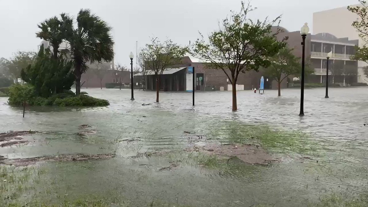
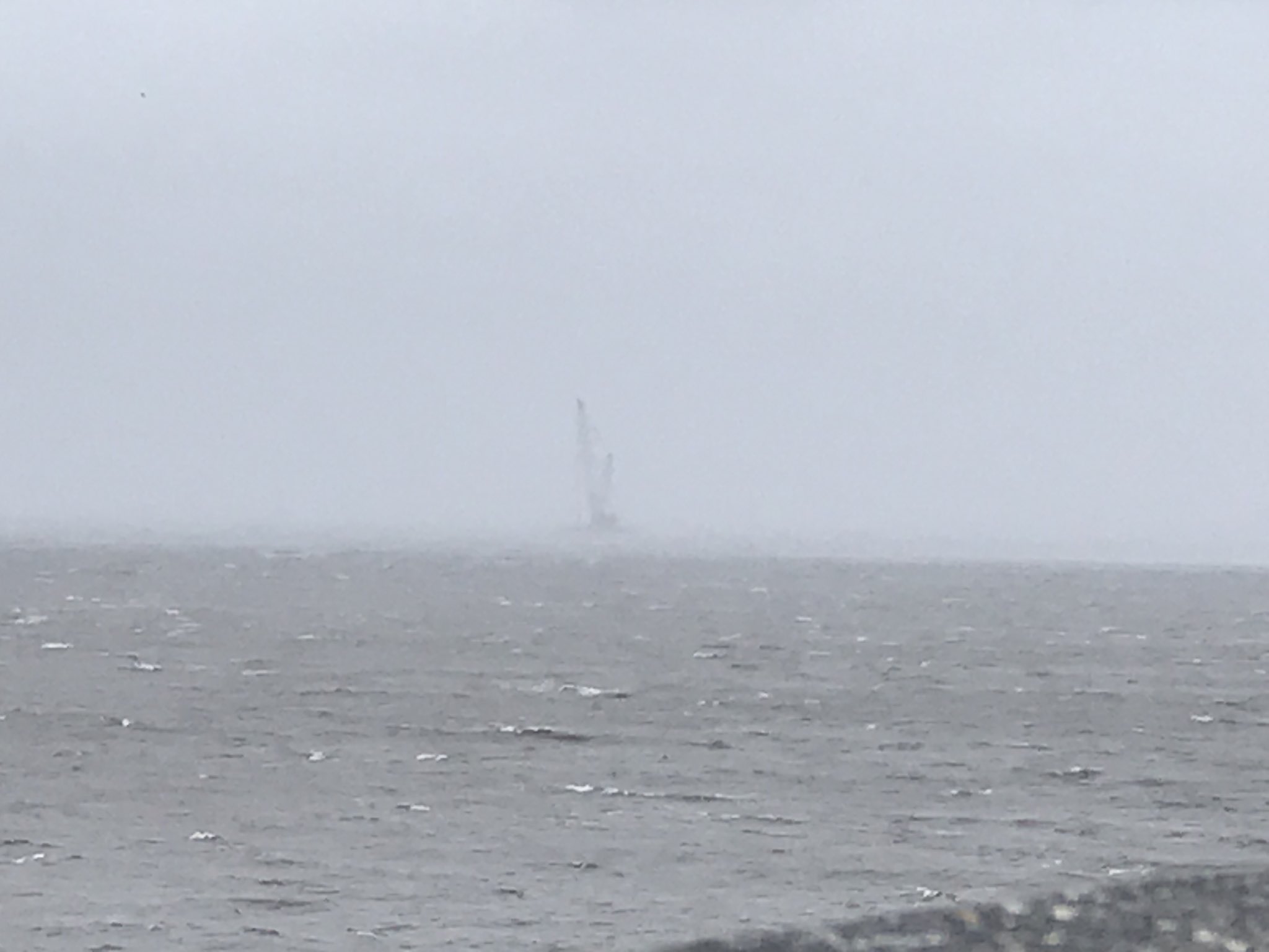
👀 While many residents were preparing for Hurricane #Sally on Monday, a quick check of the Biloxi Lighthouse camera shows someone was taking a little joyride... https://t.co/TM8zBismxX
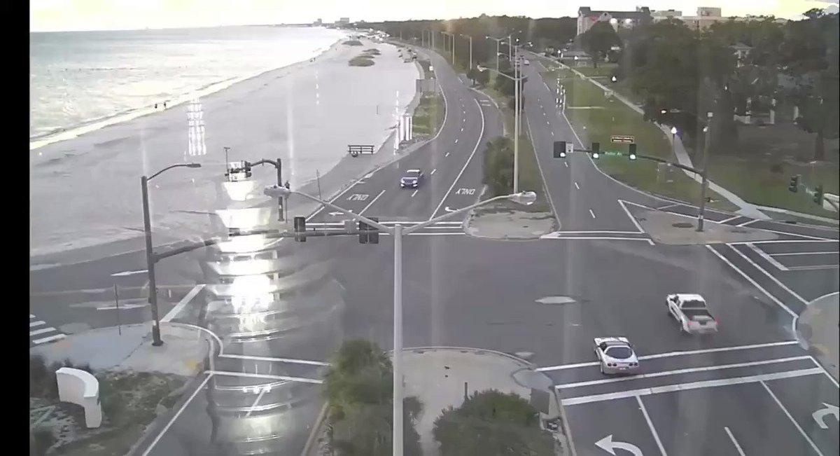
Avatar
Jeff House (Chattanooga, TN) 15-Sep-20 08:20 AM
Lack of media coverage, if true on the Cosst, is appalling. Flooding!
Avatar
TJ (Houston/Galveston TX) 15-Sep-20 08:26 AM
so far, ~60 mph winds along the coast
Avatar
Pat Kepka (Russell Co. KS) 15-Sep-20 09:21 AM
We lost buoy 42040 over night. It went adrift.
Avatar
Royce Sheibal (Papillion,NE) 15-Sep-20 09:23 AM
KVOA near hurricane force winds, with hurricane gusts, since 2pm yesterday
Avatar
Jeff House (Chattanooga, TN) 15-Sep-20 09:33 AM
Hell of a hurricane party on those two platforms last night. 🥳
Avatar
Royce Sheibal (Papillion,NE) 15-Sep-20 10:09 AM
CI# /Pressure/ Vmax 4.3 / 975.4mb/ 72.2kt
She's not dead yet. Still plenty of time for a sudden run at cat 2 again
Avatar
Jeff House (Chattanooga, TN) 15-Sep-20 10:11 AM
Probably will. VIS looks healthy again. Radar still, well... Sally.
this 5
Avatar
Royce Sheibal (Papillion,NE) 15-Sep-20 10:14 AM
24-48 hours of surge and TS wave action along much of the coast. How many of those sand bar islands will be unrecognizable after this?
Avatar
Matthew Harding (Wichita, KS) 15-Sep-20 10:19 AM
Probably will. VIS looks healthy again. Radar still, well... Sally.
@Jeff House (Chattanooga, TN) The fact that it's moving again (albeit slowly) plus the interaction with land might help tighten it up, right? (edited)
Avatar
Jeff House (Chattanooga, TN) 15-Sep-20 10:20 AM
That and pressure fall. (edited)
👍 3
Avatar
Matthew Harding (Wichita, KS) 15-Sep-20 10:28 AM
Does look like it's trying to gin up convection on the south side.
Avatar
Parker Hughes (McKinney, Tx) 15-Sep-20 10:35 AM
It sort of looks like that maybe it has a failed EWRC
Avatar
Royce Sheibal (Papillion,NE) 15-Sep-20 10:45 AM
the pinks are back on IR. its trying again really hard. but the eye is pretty ragged
Avatar
Alex V (Wausau, WI) 15-Sep-20 10:45 AM
It looks to be intensifying and building it’s structure again. Pressure is dropping and bands seem to be wrapping around the back half now. Probably because it started moving again and took a north turn (negating some shear and stopping upwelling.
Now that it’s moving again and moving more north it should have an easier time now, Royce.
Avatar
Ethan T. (Notasulga, AL) 15-Sep-20 10:47 AM
Also you actually have stronger convective activity in the SW portion of the eyewall
Avatar
Alex V (Wausau, WI) 15-Sep-20 10:47 AM
It probably won’t have a solid eyewall ring at landfall but those mid bands are starting to wrap.
Avatar
Royce Sheibal (Papillion,NE) 15-Sep-20 10:47 AM
PWET shows that low level moisture has fully insulated the SW side of the storm. this should allow it to intensify w/o that dry air being an issue
both RIPA and SHIPS refuse to remove RI from their odds tables. still 10-15% chance, which is decent. ADT is now higher than the estimated wind, which means we'll likely see winds come up within the next few hours
10-20 kts of RI is still possible before landfall, so dont count her out
Avatar
Jeff House (Chattanooga, TN) 15-Sep-20 10:50 AM
I'll look forward to another 11:30 special Advisory.
Avatar
Royce Sheibal (Papillion,NE) 15-Sep-20 10:51 AM
wind like a cat 1, but power like a cat 2. yesterday she was in beast-mode
Avatar
Alex V (Wausau, WI) 15-Sep-20 10:54 AM
I don’t think she will do a crazy RI at this point, but can easily see a steady re-intensification to Cat 2 wind speeds.
Lightning appearing more on the slightly more upshear side, we all know what that means.
Anyways I said yesterday Sally will take one of two landfall routes, a smaller more compact Cat 3 eyewall, or a larger Cat 2 eyewall. Sally seems to be taking the latter route and steadily intensifying back to C2, which is arguably the worse case scenario since a larger hurricane (albeit weaker) wind field will increase flooding hazard with higher surge and river backflow. (edited)
✅ 3
Avatar
Royce Sheibal (Papillion,NE) 15-Sep-20 11:02 AM
yup, and the models seem to think a large eye /w an pressure near 970. moving N then NNE. mobile bay is going to get smashed.
Avatar
Alex V (Wausau, WI) 15-Sep-20 11:04 AM
The western eye hot tower has a special marine warning on it.
Avatar
Royce Sheibal (Papillion,NE) 15-Sep-20 11:04 AM
KMIS, well west of KVOA /w 80kt gusts
the wind field is expanding as the eye expands. expect a pressure drop soon, i would...
Avatar
Alex V (Wausau, WI) 15-Sep-20 11:05 AM
Avatar
Pat Kepka (Russell Co. KS) 15-Sep-20 11:06 AM
Most symmetric it’s looked in its max wind band
Avatar
Alex V (Wausau, WI) 15-Sep-20 11:07 AM
Look at those 55 dBZs, that hot tower with the SMW isn’t screwing off.
Avatar
Pat Kepka (Russell Co. KS) 15-Sep-20 11:07 AM
Used to have a large broad area of max winds
Avatar
Royce Sheibal (Papillion,NE) 15-Sep-20 11:07 AM
KMIS is on the NW quad /w hurricane force, KVOA is on the NE quad /w hurricane force. there is a deep water measuring station right in the middle of the eye. water flow is from the south, allowing it to bring in deep warm water from the de soto valley
the underwater geography of this area has really prevented any upwelling, which is amazing and unlucky
✅ 2
Avatar
Pat Kepka (Russell Co. KS) 15-Sep-20 11:08 AM
Buoy 42040 would literally be in the eye right now but it got de-anchored from the strong winds so floating adrift now
Avatar
Royce Sheibal (Papillion,NE) 15-Sep-20 11:09 AM
Station 42874 - Deepwater Asgard water temps actually got UP to 85F overnight
100 feet deep and zero sign of upwelling
bouys just off the mobile coast /w 16 foot wave heights. for almost 24 hours. that erosion is going to be brutal
Avatar
Jeff House (Chattanooga, TN) 15-Sep-20 11:19 AM
Yeah Sally is fighting shear not UW.
Avatar
Royce Sheibal (Papillion,NE) 15-Sep-20 11:35 AM
So that tower slash meso vorticy was pretty amazing. The lightning too. She might have much higher winds in those mesos we just can't see them in real time at the surface. Will be interesting to see if those keep up as she comes ashore
Avatar
Alex V (Wausau, WI) 15-Sep-20 11:43 AM
Looks like she’s tightening up in the core again. Eye back under 10 miles.
Avatar
Jacob Melton (Owosso, MI) 15-Sep-20 11:45 AM
The power of storm surge is incredible in Mobile Bay, Alabama. #Sally #ALwx https://t.co/m1RriZQdRm
Avatar
beard (fort worth) 15-Sep-20 12:04 PM
@Jeff House (Chattanooga, TN). @Ethan T. (Notasulga, AL). You lose lol (edited)
🍞 3
Avatar
Jeff House (Chattanooga, TN) 15-Sep-20 12:10 PM
We won yesterday, lol!
I had Cat 2 any time during Sally.
Avatar
Alex V (Wausau, WI) 15-Sep-20 12:11 PM
Remember, the bet is that it would reach Cat 2 at some point, not landfall as one.
Also it might be reintensifying, so there’s that.
Avatar
beard (fort worth) 15-Sep-20 12:15 PM
She won't regain strength. Look at the boundary to her north lol
Avatar
Matthew Harding (Wichita, KS) 15-Sep-20 12:15 PM
Ehhhhh....still can't close off an eyewall.
Avatar
Jeff House (Chattanooga, TN) 15-Sep-20 12:15 PM
I won. Don't worry about paying though.
Mets shouldn't collect from noobs.
OOF 3
Avatar
Alex V (Wausau, WI) 15-Sep-20 12:20 PM
Is falling pressure from dropsondes a lie, Beard?
Avatar
Royce Sheibal (Papillion,NE) 15-Sep-20 12:20 PM
KVOA back up to hurricane force winds again. now from the SE
983 at 14kts. so maybe 981 estimated?
Avatar
Alex V (Wausau, WI) 15-Sep-20 12:22 PM
So Royce, how does windspeed play into sonde pressure estimates?
Avatar
Royce Sheibal (Papillion,NE) 15-Sep-20 12:24 PM
there is a scale, based on what the wind is at teh surface that you reduce the pressure based on that scale
rough guess on how close it was to the real center
Avatar
Alex V (Wausau, WI) 15-Sep-20 12:29 PM
Ah I see, makes sense given how gasses work.
Avatar
Royce Sheibal (Papillion,NE) 15-Sep-20 12:36 PM
so 983 at 0 = dead center, 983 at 14 kts = whoops, maybe 981? 983 at 50kts = oh jesus we goofed
Avatar
beard (fort worth) 15-Sep-20 12:37 PM
Noob lol
Avatar
Royce Sheibal (Papillion,NE) 15-Sep-20 12:38 PM
the cyclic hot towers would normally tell me she's about to RI. but she's so close to the coast and the eye is so ragged i dont think she can (edited)
shear isn't that bad right now. she's in a neutral 20kts or so. and if she starts to move /w the shear she might get a little boost.
its baaaaack: KVOA O 1620 29.23 -87.78 23 70 120 69.0 82.0
Avatar
Alex V (Wausau, WI) 15-Sep-20 12:42 PM
Gas physics are a lie, Beard?
Avatar
Royce Sheibal (Papillion,NE) 15-Sep-20 12:42 PM
i think he was refering to the bet
69kts sustained, 82kt gusts at KVOA again. center is roughly 23nm SW of the platform (edited)
Avatar
Alex V (Wausau, WI) 15-Sep-20 12:45 PM
I agree RI isn't likely, but steady re-intensification I can see.
Unless it somehow develops another pinhole eyewall in the next few hours, but that is a real off-chance.
Avatar
beard (fort worth) 15-Sep-20 12:50 PM
She will continue to die.
Meanwhile captian obvious is on scene
OFFICIALNWSSPOTTER 5
Avatar
Jason Harris (Detroit, Mi.) 15-Sep-20 12:57 PM
Lmao I saw that. Like wtf dude no shit
Avatar
Alex V (Wausau, WI) 15-Sep-20 01:09 PM
Sally really likes doughnuts
Avatar
Pat Kepka (Russell Co. KS) 15-Sep-20 01:10 PM
NE eyewall dropsonde.
982 mb dropsonde too
Avatar
Jeff House (Chattanooga, TN) 15-Sep-20 01:14 PM
Give Sally credit for effort, lol!
Avatar
Alex V (Wausau, WI) 15-Sep-20 01:16 PM
She's looking to inch her way back up to Cat 2. Definitely not gonna RI at this point, but a steady intensification seems to be in progress.
this 3
Avatar
Matthew Harding (Wichita, KS) 15-Sep-20 01:19 PM
90 kt winds just off the surface in the NE eyewall. Now, just gotta close the damn thing off.
Avatar
Alex V (Wausau, WI) 15-Sep-20 01:22 PM
That is still a mile and a half above the surface, gonna take time to work down.
Avatar
Cameron (Fortson, GA) 15-Sep-20 01:23 PM
STORM SURGE flooding in Gulf Shores, AL with winds ramping up. Possible direct hit ahead from #HurricaneSally @RadarOmega_WX #sally https://t.co/jh5JJA5ITI
Avatar
Zachary S (Jasper, AL) 15-Sep-20 01:24 PM
Mom's apartment is like 15 minutes from Gulf Shores in Foley, going to be a rough go with wind and flooding even that far inland
Avatar
Alex V (Wausau, WI) 15-Sep-20 01:31 PM
This is quite an improvement from the eye, it’s still ragged but it actually looks more symmetrical now. (edited)
Oh yeah, also just noticed that shearward hot tower.
Avatar
Jeff House (Chattanooga, TN) 15-Sep-20 01:32 PM
Best presentation in 15+ hours.
this 5
Avatar
Alex V (Wausau, WI) 15-Sep-20 01:35 PM
I'll say. I did mention yesterday Sally making another run for intensification once she began her north movement negating some of the shear and also moving into a less upwelling-prone environment. Her intensification episode yesterday had more to owe to the fact she unexpectedly had a small eyewall for a brief period, what we are seeing now is more on track with the original forecast. (edited)
this 3
Avatar
Zachary S (Jasper, AL) 15-Sep-20 01:44 PM
Despite the problems it's been having it's looked awesome on satellite for quite a while now. Hopefully it does stay relatively mild because that's an extremely surge prone area
Avatar
Alex V (Wausau, WI) 15-Sep-20 01:44 PM
34-33 kt sustained with 44-47 kt gusts at Fort Morgan/Dauphin island.
Avatar
Matthew Harding (Wichita, KS) 15-Sep-20 01:45 PM
Winds down to 80
Avatar
Alex V (Wausau, WI) 15-Sep-20 01:47 PM
I don't buy it.
There is probably 85+ in there somewhere.
Likely in those eastern hot towers.
Avatar
Royce Sheibal (Papillion,NE) 15-Sep-20 01:50 PM
you can see the meso-vorts in the wall now on radar. i would be you've got some near cat 2 winds in there
Avatar
Ethan T. (Notasulga, AL) 15-Sep-20 01:51 PM
At least near-85kt velocity bins in the NE quadrant
Around 7-8KFT AGL
Avatar
Alex V (Wausau, WI) 15-Sep-20 01:53 PM
I should have specified I meant mph at the surface somewhere.
But yeah those 85 knot winds under 10k feet are concerning.
Avatar
Jeff House (Chattanooga, TN) 15-Sep-20 01:54 PM
Flights measured what they measured. Radar and satellite are improving though.
Avatar
Alex V (Wausau, WI) 15-Sep-20 01:55 PM
Those hot towers are easy to miss and flights are on a set path and schedule, not blaming anyone but wouldn't be surprised if there is a greater maxima in there somewhere.
this 2
Avatar
Pat Kepka (Russell Co. KS) 15-Sep-20 02:09 PM
Latest recon pass shows Sally took a big leap to the NNE
See if another pass shows this again or not
Avatar
Ethan T. (Notasulga, AL) 15-Sep-20 02:11 PM
Well, it looks like it's getting close to closing
Avatar
Matthew Harding (Wichita, KS) 15-Sep-20 02:14 PM
Maybe @Jeff House (Chattanooga, TN) can confirm this, but to me, it looks like the mesovorts are trying to tighten up the eyewall? (edited)
Avatar
Jeff House (Chattanooga, TN) 15-Sep-20 02:16 PM
It did for a while. I'm still wait and see. Sally is definitely trying.
Avatar
Alex V (Wausau, WI) 15-Sep-20 02:17 PM
Recent couple of scans also show bands starting to form on the southern half. Makes sense, since that is the pattern northbound storms in that region typically follow.
Avatar
Pat Kepka (Russell Co. KS) 15-Sep-20 02:19 PM
F. Eye Character: Spiral Band G. Eye Shape: Not Available
VDM reports eye is a spiral band now
Avatar
Royce Sheibal (Papillion,NE) 15-Sep-20 02:20 PM
so, 3-4 foot surge already from gulfport to the PH. through 2-4?? tide cycles. thats alot of time for water to be on land.
Avatar
Alex V (Wausau, WI) 15-Sep-20 02:21 PM
52 knot winds sustained right off the coast.
Also latest recon pass declares pressure has fallen yet again to 981 mb.
Avatar
Royce Sheibal (Papillion,NE) 15-Sep-20 02:23 PM
ADT says she's getting stronger: CI# /Pressure/ Vmax 4.5 / 971.8mb/ 77.0kt
large gap between recon and ADT usually means winds haven't caught up to convection
Avatar
Alex V (Wausau, WI) 15-Sep-20 02:24 PM
She's got 12 or more hours over water, plenty of time for it to catch up.
Avatar
Royce Sheibal (Papillion,NE) 15-Sep-20 02:25 PM
dont know if she will, she's 'spinning out' and not spinning in
winds continue to blob outward, huge field. static surge now just sitting on land
Avatar
Royce Sheibal (Papillion,NE) 15-Sep-20 02:37 PM
17 ft waves 66nm from the center. enjoy 20+ hours of 17 ft waves
that bouy is only 15nm from the coast. those barriers are going to just be getting THRASHED
water temps dropped a whole 1 degree F after 24 hours of thrashing at that bouy
Avatar
Alex V (Wausau, WI) 15-Sep-20 02:39 PM
The 52 kt sonde just off the coastline speaks for itself.
Also recon is showing nearly constant 35 kt+ SFMRs throughout this entire flight path up the eastern side.
Avatar
Royce Sheibal (Papillion,NE) 15-Sep-20 02:46 PM
a little wabble east? is she aiming toward pensacola instead of mobile?
Avatar
Alex V (Wausau, WI) 15-Sep-20 02:50 PM
Sally's radar presentation looks like a stable Cat 1-2, measurements are Cat 1 but Sat is indicative of intensification. I still wouldn't write off a slow crawl but upwards towards Cat 2.
It all depends if she wants to keep getting fat or not.
Arguably a slimmer but stronger eye is preferable, Sally remaining a low-mid Cat 1 and expanding her hurricane windfield is worst case scenario for a system like Sally, it would cause river backup, higher surge, and power outages over a much wider area and much more damage overall. (edited)
It already is, in fact.
It's part of the reason I tell people to not get so hung up on Category, a fast moving pinhole Cat 4 eyewall hitting an uninhabited marsh is not going to fuck shit up nearly as much as a slow moving fat Cat 1 windfield that hits several towns and cities at once with a larger fetch over water. (edited)
this 4
Avatar
Alex V (Wausau, WI) 15-Sep-20 03:09 PM
Looks like she's trying to pop an eye on IR
Latest pass holds at 981, unfortunately the sonde in the eyewall malfunctioned. (edited)
Avatar
Ethan T. (Notasulga, AL) 15-Sep-20 03:14 PM
Think you meant the NW
Didn't even get close to the surface
Avatar
Alex V (Wausau, WI) 15-Sep-20 03:15 PM
77 kt SFMR but it's flagged.
Should be noted the eye sonde data is an hour old, recent MSLP EXTRP pass shows 977 mb
Avatar
Royce Sheibal (Papillion,NE) 15-Sep-20 03:17 PM
WV looks like an eye is warming out
Avatar
Alex V (Wausau, WI) 15-Sep-20 03:18 PM
Yeah looks like it might pop an eye soon
Avatar
Sean H(Houghton,MI) 15-Sep-20 03:19 PM
Wellp apparently one of my friends is on an oil rig south of Mobile lol. So hes getting pretty whipped by Sally rn
Avatar
Pat Kepka (Russell Co. KS) 15-Sep-20 03:20 PM
Is he on KVOA?
They’ve been getting hurricane force winds for 30 hours now (edited)
Avatar
Sean H(Houghton,MI) 15-Sep-20 03:21 PM
Asking rn
Avatar
Alex V (Wausau, WI) 15-Sep-20 03:25 PM
Eye see you.
Avatar
Matthew Harding (Wichita, KS) 15-Sep-20 03:40 PM
Anybody want to pick a landfall point? I'll go with Fort Morgan, AL.
Avatar
Ethan T. (Notasulga, AL) 15-Sep-20 03:41 PM
I'd say just ESE of Dauphin Island, AL
Avatar
Royce Sheibal (Papillion,NE) 15-Sep-20 03:42 PM
we're up to 3 hot towers rotating around the center now. it's starting the process to form the eye....
Avatar
Joey Prom (Lafayette, IN) 15-Sep-20 03:45 PM
I am pretty sure you said that at least once yesterday... 😜
Avatar
Alex V (Wausau, WI) 15-Sep-20 03:46 PM
Yesterday we had rounds of double hot towers, now it's triple
Avatar
Matthew Harding (Wichita, KS) 15-Sep-20 04:07 PM
Attempt #56 of trying to close off an eyewall.
this 5
Avatar
Royce Sheibal (Papillion,NE) 15-Sep-20 04:09 PM
yeah, in thermodynamics, the more meso-cyclones that are able to stabilize around the center of the vortex, the more likely it is to form an eye
1 then 2 then 3, then around 6 it just pops
usually we dont get to see it happen in such a close environment to a radar site, so this is actually quite interesting
she's basically hugging the coast, and still making pink IR tops is just crazy for a cat 1. this is something that michael should be doing. Laura wasn't even that cold.
Avatar
Alex V (Wausau, WI) 15-Sep-20 04:17 PM
18:55z eye sonde broke (edited)
Avatar
Avatar
Pat Kepka (Russell Co. KS) 15-Sep-20 04:19 PM
981 mb at 40 knots
Avatar
Alex V (Wausau, WI) 15-Sep-20 04:20 PM
Looks like they missed the center by quite a ways
Honestly it looks like this eye attempt might actually be successful (edited)
Avatar
Garrett (Hillsdale MI) 15-Sep-20 04:26 PM
Dropsondes today be like: imma head out
Avatar
Matthew Harding (Wichita, KS) 15-Sep-20 04:27 PM
Wonder if that last sonde was in the left eyewall. Kinda looks that way.
Avatar
Alex V (Wausau, WI) 15-Sep-20 04:29 PM
It was, which means the pressure is probably sub 980 in the center
Avatar
Pat Kepka (Russell Co. KS) 15-Sep-20 04:30 PM
Another eye drop
980 mb at 17 knots
Avatar
Ethan T. (Notasulga, AL) 15-Sep-20 04:30 PM
That would suggest ~978mb
Avatar
Pat Kepka (Russell Co. KS) 15-Sep-20 04:31 PM
New VDM showing an open eye to the south
Avatar
Ethan T. (Notasulga, AL) 15-Sep-20 04:36 PM
mid-level eye feature is becoming more apparent on visible
Avatar
Royce Sheibal (Papillion,NE) 15-Sep-20 04:36 PM
its happening
Hank 2
IF this works out a real eye finally, like the models suggested, (HWRF,HMON), it could make it to sub-970 before landfall
Avatar
Matthew Harding (Wichita, KS) 15-Sep-20 04:47 PM
Still at 80 as of 5 pm advisory
Avatar
Royce Sheibal (Papillion,NE) 15-Sep-20 04:48 PM
KVOA O 2000 29.23 -87.78 23 134 200 67.0 81.0 out favorite platform now has SSW winds at 67kts
👍 2
Avatar
Alex V (Wausau, WI) 15-Sep-20 04:48 PM
Yes, but at 979.
Avatar
Royce Sheibal (Papillion,NE) 15-Sep-20 04:50 PM
recon pressure showed 975 but they can't get a dropsonde to confirm, they are crapping out like 30 of them
Avatar
Alex V (Wausau, WI) 15-Sep-20 04:51 PM
What is going on with the sondes today?
Avatar
Royce Sheibal (Papillion,NE) 15-Sep-20 04:51 PM
freaky storm /w no solid eyewall or eye, gotta drop all over
dropsonde difficulty mode: nightmare sally
plus their flights have been getting hammered by turbulence. those are insane hot towers for such a lame cat 1. they will be getting bounced up and down a lot
Avatar
Royce Sheibal (Papillion,NE) 15-Sep-20 05:00 PM
mmmm those towers are ripping aroudn the north side like paul walker around a corner and into a palm tree
OOF 5
Avatar
Cameron (Fortson, GA) 15-Sep-20 05:01 PM
Can we don't
Spann 3
Avatar
Royce Sheibal (Papillion,NE) 15-Sep-20 05:02 PM
i like how the entire panhandle of florida just became a banana there
Avatar
Cameron (Fortson, GA) 15-Sep-20 05:03 PM
Pretty much
Hope no truck drivers wanting to go up I-85 lol
Avatar
Pat Kepka (Russell Co. KS) 15-Sep-20 05:13 PM
#Sally making yet another attempt at intensification of its inner core this evening. Note the decreased precipitation in the eye which indicates increased subsistence (sinking motion), a sign of a stronger circulation. Regardless, rain & surge still by far biggest threats! ...
Attempt #57 for a closed eyewall
😂 4
Avatar
Royce Sheibal (Papillion,NE) 15-Sep-20 05:15 PM
"The Little Eye that Could" (n't)
😂 3
Avatar
Alex V (Wausau, WI) 15-Sep-20 05:17 PM
Though this time it is looking more successful
Avatar
Royce Sheibal (Papillion,NE) 15-Sep-20 05:18 PM
Avatar
Parker Hughes (McKinney, Tx) 15-Sep-20 05:20 PM
When these 2 bands get onshore expect the Tornado threat to go up with them
this 2
Avatar
Pat Kepka (Russell Co. KS) 15-Sep-20 05:25 PM
Dauphin Island with a gust to 72 mph
Fort Morgan with a gust to 75 mph
Avatar
Pat Kepka (Russell Co. KS) 15-Sep-20 05:54 PM
KVOA with a 93 knot (108mph) wind gust
Avatar
Cameron (Fortson, GA) 15-Sep-20 05:58 PM
👍 4
wxtwitter 2
Avatar
Alex V (Wausau, WI) 15-Sep-20 05:58 PM
Closed but ragged
But still, closed.
Avatar
Hunter Hollman (York, PA) 15-Sep-20 06:08 PM
Chill, Sally
Avatar
Holly Pajak (London, Ontario) 15-Sep-20 06:29 PM
beach cam at a resort in Panama City
Avatar
Royce Sheibal (Papillion,NE) 15-Sep-20 06:41 PM
she's trying again...
Avatar
Alex V (Wausau, WI) 15-Sep-20 06:42 PM
KOVA sustained at 80 knots
Gust 90 knots
Avatar
Garrett (Hillsdale MI) 15-Sep-20 06:45 PM
Has definitely restrengthened a bit then
Avatar
Alex V (Wausau, WI) 15-Sep-20 06:45 PM
Not even the strongest part of the eyewall
Avatar
Matthew Harding (Wichita, KS) 15-Sep-20 06:46 PM
100-105 mph winds aloft just south of Gulf Shores.
category2 4
Avatar
Alex V (Wausau, WI) 15-Sep-20 06:46 PM
How high?
Avatar
Matthew Harding (Wichita, KS) 15-Sep-20 06:47 PM
Looks like 2-3k ft.
Avatar
Alex V (Wausau, WI) 15-Sep-20 06:47 PM
That's close enough to the surface to cause concern.
Probably mixing down as gusts already, if it keeps improving it could become sustained.
Avatar
Ryan Hearne(Tyler,Tx) 15-Sep-20 06:48 PM
How long until we get a next recon fix?
Avatar
Matthew Harding (Wichita, KS) 15-Sep-20 06:49 PM
Those 100-105 mph bins in the velocities are not widespread. Generally 85-100 mph winds at that height. Supports 80 mph storm. Could certainly see gusts 100+.
Avatar
Alex V (Wausau, WI) 15-Sep-20 06:51 PM
True, but we got an 80 knot/92 mph reading from KOVA
Avatar
Matthew Harding (Wichita, KS) 15-Sep-20 06:56 PM
KVOA is elevated IIRC.
Avatar
Alex V (Wausau, WI) 15-Sep-20 07:06 PM
Not by a dramatic amount.
Avatar
Alex V (Wausau, WI) 15-Sep-20 07:22 PM
Anyways recon is almost there and we will have a better idea soon
🤘 1
Avatar
Alex V (Wausau, WI) 15-Sep-20 07:30 PM
Recon just entered Sally and we already have 35+ kt SFMRs
Avatar
Ethan T. (Notasulga, AL) 15-Sep-20 07:37 PM
~70kt SFMR in the SW quadrant of Sally now
FL winds at hurricane force as well
Avatar
Royce Sheibal (Papillion,NE) 15-Sep-20 07:37 PM
Microwave has completed the eyewall
Avatar
Alex V (Wausau, WI) 15-Sep-20 07:42 PM
Holy crap, not even close to the center yet.
Avatar
Cameron (Fortson, GA) 15-Sep-20 07:45 PM
Avatar
TJ (Houston/Galveston TX) 15-Sep-20 07:45 PM
definitely not going to hit my peak 112 tonight
Avatar
Cameron (Fortson, GA) 15-Sep-20 07:45 PM
SFMR's look 75kt, Recon got 972, 5-6 give or take, definitely strengthening a bit
Avatar
Alex V (Wausau, WI) 15-Sep-20 07:46 PM
That is the weaker side too.
Seems hurricane-force winds have completely wrapped. It is Big Chungus Cat 1
Possibly 2
Avatar
Cameron (Fortson, GA) 15-Sep-20 07:47 PM
Forecast rain totals here 9-10 inches, dread
Avatar
Jacob H (North AL Skywarn) 15-Sep-20 07:48 PM
Wow... winds are whipping and this thing isn't going anywhere anytime soon..
@Cameron (Fortson, GA) yea, current rainfall totals already approaching 4-6 in
Avatar
Cameron (Fortson, GA) 15-Sep-20 07:54 PM
Gonna be a long night for them
Worst thing this thing can do is try an eyewall contraction and have induced land friction and dinural cycles try to Strengthen it right up to landfall
Avatar
Alex V (Wausau, WI) 15-Sep-20 07:56 PM
976 dropsonde btw.
This is a strengthening system for sure.
Avatar
Cameron (Fortson, GA) 15-Sep-20 08:01 PM
okay....
Avatar
Alex V (Wausau, WI) 15-Sep-20 08:03 PM
More malfunctions.
Recon having loads of problems today
Avatar
Royce Sheibal (Papillion,NE) 15-Sep-20 08:09 PM
i see blue on IR. i think we got ourselves a real eye
CI# /Pressure/ Vmax 4.6 / 971.8mb/ 79.6kt Final T# Adj T# Raw T# 4.6 4.6 5.7
some very big chungus raw T
Avatar
Alex V (Wausau, WI) 15-Sep-20 08:14 PM
Too bad recon malfunctioned, I'd like to see what the NE maxima is.
Avatar
Royce Sheibal (Papillion,NE) 15-Sep-20 08:16 PM
offshore wave heights up to 18ft
Avatar
Alex V (Wausau, WI) 15-Sep-20 08:26 PM
KOVA sustained at 76 knots.
Avatar
Nate O. (DFW - Wylie, Texas) 15-Sep-20 08:29 PM
How fast (slow) is Sally moving now?
Avatar
Cameron (Fortson, GA) 15-Sep-20 08:34 PM
Transformers blowing in Golf Shores
Sparks and more transformers
@susanaronRigsbyOSC: Just witnessed this large boat capsize and sink in front of my very eyes in the Dauphin Island harbor in Alabama. #Sally #ALwx @NHC_Atlantic @NWSMobile
Gulf Coast people are weird, m'kay? @CBSNews @SkylerHenry #Sally
Texas storm chasers talking about hoping a Mcdonalds stays open while transformers are going off, and sparks are flying in the air
Avatar
James K (Jeffco, Colorado) 15-Sep-20 08:48 PM
@Nate O. (DFW - Wylie, Texas) Last I saw, it was moving at 2mph
Avatar
Glen Heinz (Greenville, SC) 15-Sep-20 08:54 PM
Somebody is swimming in that pool
3 people in the pool during a Hurricane.
@Holly Pajak (London, Ontario)
Avatar
Jim Martin (Findlay, Ohio) 15-Sep-20 09:04 PM
I was just wondering about the eye, watching it here on GREarth
Avatar
Jaden L. (Topeka, KS) 15-Sep-20 09:05 PM
Hourly update increases winds to 85 mph
Avatar
Jim Martin (Findlay, Ohio) 15-Sep-20 09:05 PM
not surprised
Avatar
Jacob Melton (Owosso, MI) 15-Sep-20 09:05 PM
Avatar
Jim Martin (Findlay, Ohio) 15-Sep-20 09:06 PM
I keep saying that New Orleans got away with one here
especially with Sally taking the right hand turn when it did
Avatar
Holly Pajak (London, Ontario) 15-Sep-20 09:34 PM
Avatar
Pat Kepka (Russell Co. KS) 15-Sep-20 09:45 PM
Winds ramping up on KVOA again
75 knots sustained with gusts to 90 knots
Avatar
Ethan T. (Notasulga, AL) 15-Sep-20 10:07 PM
969.7mb extrapolated min. pressure from recon center fix
Avatar
Pat Kepka (Russell Co. KS) 15-Sep-20 10:13 PM
99 knots above the surface not by much
Note the sonde did not reach the surface
Avatar
Pat Kepka (Russell Co. KS) 15-Sep-20 10:24 PM
VDM also with eye open to SE
Avatar
Jacob Melton (Owosso, MI) 15-Sep-20 10:42 PM
A significant water main break has occurred on Pensacola Beach. Crews are unable to respond due to current storm conditions. ECUA will have to shut off the water system at approx. 11:00 pm tonight. Residents who are still on Pensacola Beach are urged to store water if possib...
Hank 5
Avatar
Jim Martin (Findlay, Ohio) 15-Sep-20 10:42 PM
well
Avatar
Nate O. (DFW - Wylie, Texas) 15-Sep-20 10:43 PM
That sucks. One hours notice to fill your bathtub
Avatar
Jim Martin (Findlay, Ohio) 15-Sep-20 11:02 PM
Avatar
Pat Kepka (Russell Co. KS) 15-Sep-20 11:07 PM
Getting another recon pass soon
Avatar
Howard Robinson(Vancouver,BC) 15-Sep-20 11:08 PM
Sally a cat 2?
Avatar
Pat Kepka (Russell Co. KS) 15-Sep-20 11:08 PM
85 mph cat. 1
Avatar
Howard Robinson(Vancouver,BC) 15-Sep-20 11:08 PM
I just saw at the top, *DOH**
Avatar
Pat Kepka (Russell Co. KS) 15-Sep-20 11:08 PM
Only 10 knots more for cat. 2 though
Avatar
Howard Robinson(Vancouver,BC) 15-Sep-20 11:08 PM
new advisory saying 85
Avatar
Jaden L. (Topeka, KS) 15-Sep-20 11:08 PM
Weather weenies are saying its a cat 2 Yao
Avatar
Hunter Hollman (York, PA) 15-Sep-20 11:17 PM
It has cat 2 winds at around 5k feet but it's probably not that at the surface
Avatar
Howard Robinson(Vancouver,BC) 15-Sep-20 11:18 PM
REEEEEEEE, I deserve a CAT 2
lol
Avatar
Pat Kepka (Russell Co. KS) 15-Sep-20 11:24 PM
93 knots Flight level
74 knots SFMR
Avatar
Pat Kepka (Russell Co. KS) 15-Sep-20 11:41 PM
971 mb dropsonde
Avatar
Parker Hughes (McKinney, Tx) 15-Sep-20 11:41 PM
#WPC_MD 0760 affecting Gulf Coast from Mobile Bay, AL to Apalachee Bay, FL, #flwx #alwx, https://t.co/qMCQUIIy3Y
Avatar
Matthew Harding (Wichita, KS) 15-Sep-20 11:42 PM
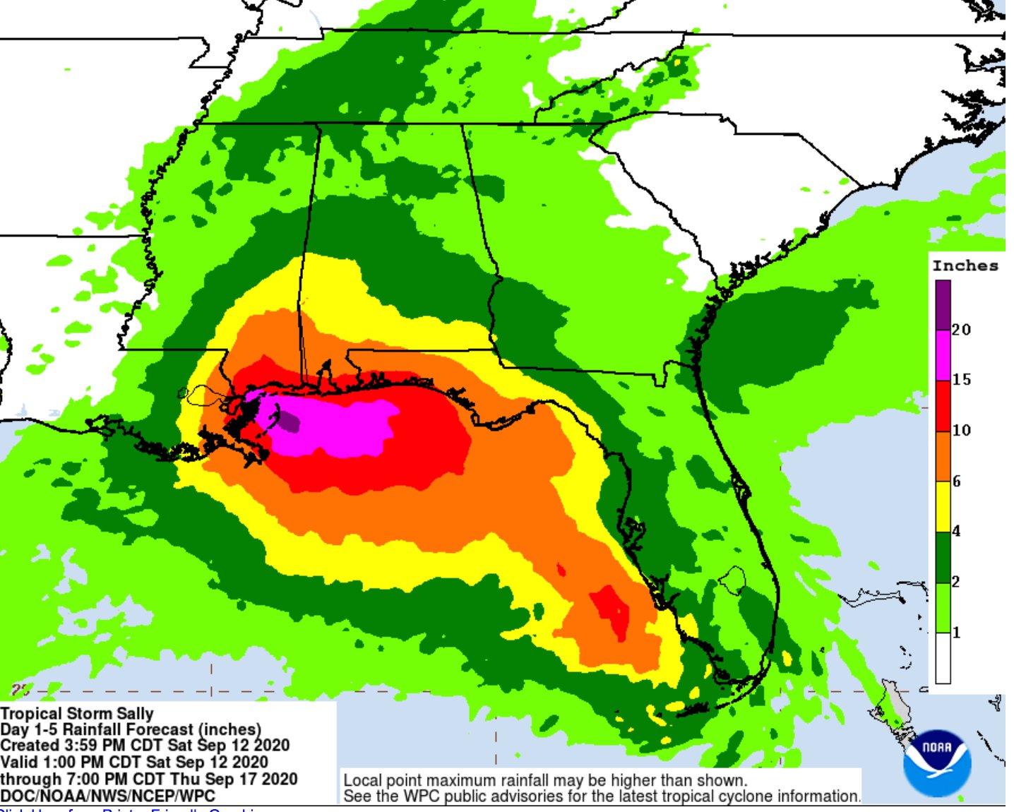
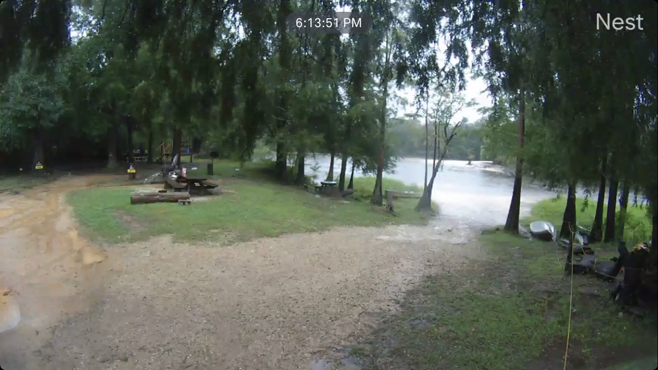
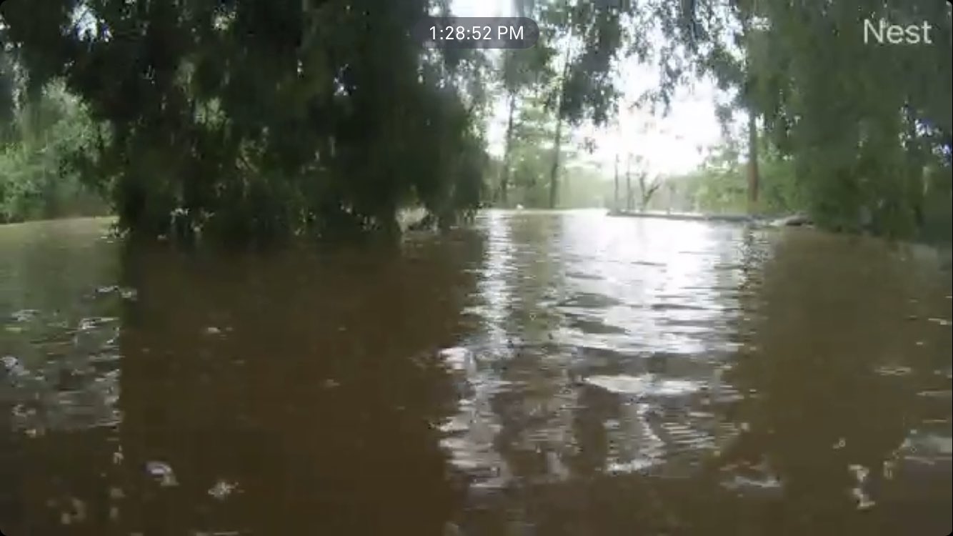
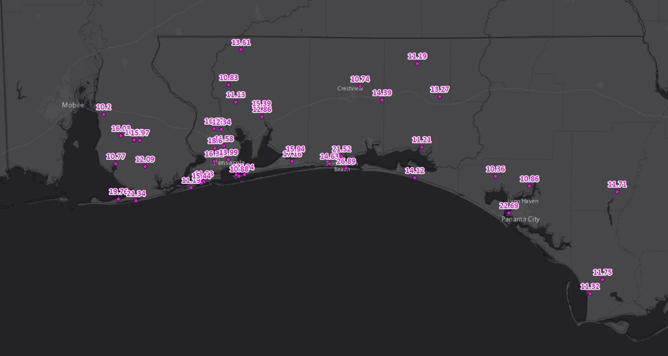
☔1030pm - Rainfall Totals OVER 16 INCHES so far and it is still absolutely pouring along the coast this evening. Up to 16.27" near NAS Pensacola right now. #flwx #Sally https://t.co/TvUWC4wluz
Avatar
Pat Kepka (Russell Co. KS) 15-Sep-20 11:43 PM
Peak 97kt FL, 82kt SFMR in the NW quad (edited)
This might be a cat. 2 again
Avatar
Jaden L. (Topeka, KS) 15-Sep-20 11:44 PM
idk that would be interesting with the forecast set at 90
Avatar
Royce Sheibal (Papillion,NE) 15-Sep-20 11:49 PM
CI# /Pressure/ Vmax 5.5 / 952.5mb/102.0kt Final T# Adj T# Raw T# 5.5 5.9 5.9
ADT CAT3 anyone?
🤣 1
Avatar
Hunter Hollman (York, PA) 15-Sep-20 11:50 PM
We'll see at the 12 PM EST advisory
Idk about Cat 3 lol
Avatar
Royce Sheibal (Papillion,NE) 15-Sep-20 11:50 PM
adt is a leading indicator not a trailing, so keep that in mind
Avatar
Pat Kepka (Russell Co. KS) 15-Sep-20 11:51 PM
Buoy 42012 is still at a warm 83.1 degrees for SST
Avatar
Royce Sheibal (Papillion,NE) 15-Sep-20 11:51 PM
satcon, the more conservative sat estimate, is at 85kts
intense towers still blowing up near the eye, this could easily hit cat 3 by landfall
just waiting for the pressure to match the clouds
Avatar
Pat Kepka (Russell Co. KS) 15-Sep-20 11:54 PM
Numerous 100 kt readings not far above the surface
Think it only weakened so much at the end because it rotated to a weaker quad
Avatar
Matthew Harding (Wichita, KS) 15-Sep-20 11:56 PM
That Northwest eyewall is no joke
Avatar
Royce Sheibal (Papillion,NE) 15-Sep-20 11:57 PM
that 109 should mix down to about 94kts in a fully matured eyewall
Avatar
Jaden L. (Topeka, KS) 15-Sep-20 11:57 PM
Every time I go to sleep a hurricane seems to rapidly intensity
troll 2
Avatar
Royce Sheibal (Papillion,NE) 15-Sep-20 11:57 PM
its noctural max, with infinite OHC
Avatar
Hunter Hollman (York, PA) 15-Sep-20 11:57 PM
Avatar
Pat Kepka (Russell Co. KS) 15-Sep-20 11:58 PM
That is not... good
Avatar
Jaden L. (Topeka, KS) 15-Sep-20 11:58 PM
I thought it was closed for a few hours
Avatar
Hunter Hollman (York, PA) 15-Sep-20 11:58 PM
This thing has been an absolute rollercoaster
rollercoaster 1
Avatar
Jaden L. (Topeka, KS) 15-Sep-20 11:59 PM
It cant make up its mind
Avatar
Hunter Hollman (York, PA) 15-Sep-20 11:59 PM
First it unexpectedly rocketed to cat 2 with that small eye, then it started crapping the bed with a pretty bad center, now it's getting it's crap together just off of land
Avatar
Jaden L. (Topeka, KS) 15-Sep-20 11:59 PM
The original nhc forecast was on point oddly enough going back a couple days
Avatar
Pat Kepka (Russell Co. KS) 15-Sep-20 11:59 PM
This is the first recon confirmed closed
Avatar
Jaden L. (Topeka, KS) 15-Sep-20 11:59 PM
Ohhh ok recon confirmation
Avatar
Jacob Melton (Owosso, MI) 16-Sep-20 12:00 AM
90 MPH
Avatar
beard (fort worth) 16-Sep-20 12:00 AM
(Points to frontal boundary)
Avatar
Jacob Melton (Owosso, MI) 16-Sep-20 12:00 AM
Avatar
Avatar
John Choquette (Edmond, OK) 16-Sep-20 12:09 AM
really blowing up at the 11th hour
Avatar
Royce Sheibal (Papillion,NE) 16-Sep-20 12:09 AM
12 hours until landfall, no sign of weakening, 972mb....she make it to what...957?
Avatar
Pat Kepka (Russell Co. KS) 16-Sep-20 12:09 AM
Buoy 42012 with sustained winds of 72 mph
Cranking up near the surface obs
Avatar
Jaden L. (Topeka, KS) 16-Sep-20 12:10 AM
957? That wont tell the story ill say that much
Avatar
Royce Sheibal (Papillion,NE) 16-Sep-20 12:12 AM
several models hwrf, hmon, euro, all had sub-960 landfalls in runs 2 days ago
so its within the realm of posibility, OHC isn't stopping it
Avatar
Garrett (Hillsdale MI) 16-Sep-20 12:14 AM
The fact this is moving so slow is literally letting it pull a Harvey
Avatar
Jaden L. (Topeka, KS) 16-Sep-20 12:14 AM
I dont know how much upwelling is impacting it like it is crawling
My goodness
Harvey, Florence, Imelda, (Sally?)
Avatar
Pat Kepka (Russell Co. KS) 16-Sep-20 12:16 AM
According to buoy 42012 there is minimal upwelling so far
Avatar
Royce Sheibal (Papillion,NE) 16-Sep-20 12:16 AM
we did some research yesterday on upwelling in shallow ocean shelfs
basically there is little to NO upwelling, because the integrated shelf temperature is actually higher than in deep water
Avatar
Jaden L. (Topeka, KS) 16-Sep-20 12:17 AM
Also this is the Gulf we are talking about which is bath water normally
Avatar
Royce Sheibal (Papillion,NE) 16-Sep-20 12:17 AM
so while it might lose 1-2 F, it won't lose 5-6F like in deep water stalls
Avatar
Garrett (Hillsdale MI) 16-Sep-20 12:18 AM
This is coming up in places like every single storm, the southern eyewall isn't substantially weaker because it's not showing higher velocities on Radarscope, it's just because it's further away and people still don't get that
People think the costal radars are magic and can get both sides of the eyewall this far out
Avatar
Jaden L. (Topeka, KS) 16-Sep-20 12:18 AM
Yeah unfortunately been seeing a lot of things the past couple hours
Avatar
Nate O. (DFW - Wylie, Texas) 16-Sep-20 12:20 AM
We thinking KMOB is gonna stay online now through the next 24 hours?
Avatar
Royce Sheibal (Papillion,NE) 16-Sep-20 12:22 AM
jesus that eyewall looks amazing. its nice and round, with a solid meso-vort ont he east side just throwing shade like a MF
Avatar
Garrett (Hillsdale MI) 16-Sep-20 12:22 AM
I feel bad for the NHC again
They've had to bounce the forecast up and down like 4 times
And now it's probably gonna end up over again
Avatar
Royce Sheibal (Papillion,NE) 16-Sep-20 12:24 AM
anyone else notice the black ring of death is starting to fill in?
Hank 1
dvorak is going bonnkers with this storm, the black ring of death = cat 3
CI# /Pressure/ Vmax 5.8 / 946.1mb/109.8kt Final T# Adj T# Raw T# 5.8 5.9 5.9
968 last pass
Avatar
Glen Heinz (Greenville, SC) 16-Sep-20 12:28 AM
getting closer
Avatar
Avatar
Pat Kepka (Russell Co. KS) 16-Sep-20 12:29 AM
93 mph gust at buoy 42012. Still sustained at 72 mph
Avatar
Royce Sheibal (Papillion,NE) 16-Sep-20 12:29 AM
969 /w 99kts
its a cat 3 boys
Avatar
Pat Kepka (Russell Co. KS) 16-Sep-20 12:29 AM
That one didn’t reach the surface
987 mb is the estimated surface for that drop
Avatar
Royce Sheibal (Papillion,NE) 16-Sep-20 12:30 AM
jesus, they are still losing drops again today?
Avatar
Pat Kepka (Russell Co. KS) 16-Sep-20 12:32 AM
102 knot FL winds
5 readings of at least 98 knot FL
SFMR still around 80ish knots (edited)
These are all higher recon readings than we had when she was a cat. 2
Avatar
beard (fort worth) 16-Sep-20 12:35 AM
Explain how a storm can go from a cat 1 to a cat 3 with in a few hours.
Avatar
Royce Sheibal (Papillion,NE) 16-Sep-20 12:35 AM
we measure the storm based on wind velocity, a flawed system (edited)
the storm has been a cat 2 / borderline cat 3 based on IKE for a while now
Avatar
beard (fort worth) 16-Sep-20 12:36 AM
It's been a cat 1 according to NWS for awhile.
Avatar
Royce Sheibal (Papillion,NE) 16-Sep-20 12:37 AM
yup, and they use wind velocity aka the saffir simpson scale. which is old and outdated
Avatar
beard (fort worth) 16-Sep-20 12:37 AM
Which is offical.
Avatar
Royce Sheibal (Papillion,NE) 16-Sep-20 12:37 AM
which is the problem
let me introduce you to IKE, a different way of thinking about hurricanes.
Avatar
beard (fort worth) 16-Sep-20 12:38 AM
You see 1 thing that says it's a cat 3 in one area. Doesn't make it a cat 3 in the entire storm.
Avatar
Alex V (Wausau, WI) 16-Sep-20 12:38 AM
That is where I need to disagree, the SS scale is still good for determining wind impacts.
It can be thought of as an extension of the Beaufort scale.
Avatar
beard (fort worth) 16-Sep-20 12:39 AM
That's like saying a 120mph wind gust means the storm is a 120mph storm. Instead of rating it on what it's constantly doing.
Avatar
Glen Heinz (Greenville, SC) 16-Sep-20 12:39 AM
beau is like ships navy or military right?
Avatar
Royce Sheibal (Papillion,NE) 16-Sep-20 12:40 AM
Avatar
Glen Heinz (Greenville, SC) 16-Sep-20 12:40 AM
To be fair if they get a gust on drops they rate it as such.
Avatar
Alex V (Wausau, WI) 16-Sep-20 12:40 AM
And to be fair, the Beaufort scale itself is flawed and old, but going off of it was the general idea when the SS scale was made.
Avatar
Royce Sheibal (Papillion,NE) 16-Sep-20 12:40 AM
a different way of thinking about storms, the IKE scale
Avatar
beard (fort worth) 16-Sep-20 12:40 AM
I was in ike.
Avatar
Glen Heinz (Greenville, SC) 16-Sep-20 12:40 AM
not the cane
Avatar
beard (fort worth) 16-Sep-20 12:40 AM
Oh lol
Avatar
Royce Sheibal (Papillion,NE) 16-Sep-20 12:41 AM
it was inspired by IKE
because he did way more damage than his category indicated
Avatar
Glen Heinz (Greenville, SC) 16-Sep-20 12:41 AM
I have no idea on IKE. Offically it's cat1 meow.
Avatar
beard (fort worth) 16-Sep-20 12:42 AM
Most of ikes damage was flood related. Except on galveston island. I had flash backs of that crap during laura.
Ok the meow threw me off.
Avatar
Royce Sheibal (Papillion,NE) 16-Sep-20 12:42 AM
Avatar
Alex V (Wausau, WI) 16-Sep-20 12:43 AM
To be fair, the Saffir Simpson scale is now called the Saffir Simpson wind scale and mentions of surge were dropped from it years ago.
this 1
Avatar
Jacob Melton (Owosso, MI) 16-Sep-20 12:43 AM
1135pm - Buoy 42012 is now gusting to 94 mph with #Sally.
Avatar
Royce Sheibal (Papillion,NE) 16-Sep-20 12:43 AM
thats like 20 miles off the coast, gonna be a rough night
Avatar
beard (fort worth) 16-Sep-20 12:49 AM
Powers flashing in orange beach and data just went to crap.
Avatar
Matthew Harding (Wichita, KS) 16-Sep-20 12:49 AM
The East eyewall is vicious. -123 mph inbound at 4600 ft
Avatar
Royce Sheibal (Papillion,NE) 16-Sep-20 12:51 AM
gulf shores to pensaco getting trashed tonight. for like 12 hours.
Avatar
Garrett (Hillsdale MI) 16-Sep-20 12:52 AM
Avatar
Glen Heinz (Greenville, SC) 16-Sep-20 12:53 AM
Recon continuing to find higher winds, with 117 mph flight-level winds just measured in the eastern eyewall. #Sally is on the cusp of Cat 2 intensity
Likes
184
Avatar
Pat Kepka (Russell Co. KS) 16-Sep-20 12:53 AM
Sustained 10 meter winds of 80 mph. 97 mph wind gust at 42012 (edited)
Avatar
Royce Sheibal (Papillion,NE) 16-Sep-20 12:55 AM
go to the mobile radar, and look at ZDR. very intense updrafts along the SE side of the eye in the meso-vortex area. updrafts similar to supercells
Avatar
Jacob Melton (Owosso, MI) 16-Sep-20 12:55 AM
category2
Avatar
Pat Kepka (Russell Co. KS) 16-Sep-20 12:55 AM
Sally officially a cat. 2
category2 2
Avatar
Jacob Melton (Owosso, MI) 16-Sep-20 12:56 AM
Avatar
Glen Heinz (Greenville, SC) 16-Sep-20 12:56 AM
11 NM to coastline (edited)
Avatar
Pat Kepka (Russell Co. KS) 16-Sep-20 12:58 AM
I think it’s a little further than that
Unless you mean the eyewall
Avatar
Jaden L. (Topeka, KS) 16-Sep-20 12:59 AM
Man
Avatar
Glen Heinz (Greenville, SC) 16-Sep-20 12:59 AM
@Pat Kepka (Russell Co. KS) nop on gr2 I've got that
Avatar
Jaden L. (Topeka, KS) 16-Sep-20 12:59 AM
If theres good news, it didnt continue to strengthen from 100 yesterday I guess (edited)
Avatar
Glen Heinz (Greenville, SC) 16-Sep-20 12:59 AM
Latest RHIs of Z and Zdr (azimuth angle of 147°) showing echo tops 9-10 km in some of the deeper convection, with a well-defined bright band located around 4.5 km, with some upward displacement of the melting layer in the convection @OU_SRs @ousom @NWSMobile
Avatar
Jaden L. (Topeka, KS) 16-Sep-20 01:00 AM
If further strengthening becomes likely before Sally's center reaches the northern Gulf coast later this morning, then a Special Advisory will be issued at 100 AM CDT. I will have to see what they do at the 1:00 advisory
Avatar
Garrett (Hillsdale MI) 16-Sep-20 01:01 AM
Recon about to do a NE to SW pass
Avatar
Glen Heinz (Greenville, SC) 16-Sep-20 01:02 AM
Avatar
Pat Kepka (Russell Co. KS) 16-Sep-20 01:06 AM
105 mph gust at buoy 42012 (edited)
Sustained 10 meter winds at 84 mph
Avatar
Glen Heinz (Greenville, SC) 16-Sep-20 01:07 AM
?
Avatar
Royce Sheibal (Papillion,NE) 16-Sep-20 01:08 AM
23 ft waves at 42012. those are gonna look great on the beach, who's got a webcam?
Avatar
Glen Heinz (Greenville, SC) 16-Sep-20 01:09 AM
#Sally has strengthened into a category 2 hurricane on the Midnight CDT update with 100-mph winds. More: https://t.co/tW4KeFW0gB
Avatar
Matthew Harding (Wichita, KS) 16-Sep-20 01:10 AM
Cox is working on the internet in my neighborhood. Fine time to do it with a Hurricane making landfall.
facepalm 4
🇫 3
Avatar
Jaden L. (Topeka, KS) 16-Sep-20 01:10 AM
I thought this storm was gonna weaken up until landfall until this happened
ik what you mean, Cox always seems to go out at the worst of times
Avatar
Jacob Melton (Owosso, MI) 16-Sep-20 01:11 AM
Spectrum does that to me too occasionally AngryTom
OOF 2
Avatar
Glen Heinz (Greenville, SC) 16-Sep-20 01:11 AM
Gulf Shores is just starting to feel eyewall
Avatar
Royce Sheibal (Papillion,NE) 16-Sep-20 01:12 AM
reed appears to be in gulf shores taking a solid hit, looks brutal
East 3
Avatar
Glen Heinz (Greenville, SC) 16-Sep-20 01:12 AM
Avatar
Matthew Harding (Wichita, KS) 16-Sep-20 01:13 AM
ik what you mean, Cox always seems to go out at the worst of times
@Jaden L. (Topeka, KS) Cox is overpriced and has brutal service. I wish there was a more reputable internet provider down here.
Avatar
Royce Sheibal (Papillion,NE) 16-Sep-20 01:14 AM
we have cox in omaha here, best service you can get. a little pricy. kinda sad when everyone complains about the best service by speed / customer satisfaction. just goes to show how terrible all the others are
Avatar
Jaden L. (Topeka, KS) 16-Sep-20 01:14 AM
Yeah, my internet speeds aren't that great it's sometimes difficult with a 10 Mbps upload
Avatar
Glen Heinz (Greenville, SC) 16-Sep-20 01:15 AM
Avatar
Royce Sheibal (Papillion,NE) 16-Sep-20 01:16 AM
hope he's ready to enjoy 6-12 hours at hurricane force sustained
Avatar
Jaden L. (Topeka, KS) 16-Sep-20 01:16 AM
Also Cox kinda has a monopoly here so we do not have much of a choice Landfall what, late tomorrow morning, early afternoon , something like that
Avatar
Royce Sheibal (Papillion,NE) 16-Sep-20 01:17 AM
7am rough guess
Avatar
Avatar
Jaden L. (Topeka, KS) 16-Sep-20 01:18 AM
I saw on the coast in the 12H slot on the Discussion so I kinda figured
Avatar
Drew Terril (Yukon, OK) 16-Sep-20 01:18 AM
Jeez I have 100mbps with Cox in OKC, and there are three tiers above me
Avatar
John Choquette (Edmond, OK) 16-Sep-20 01:18 AM
Here is Hail Trace's livefeed
Avatar
Glen Heinz (Greenville, SC) 16-Sep-20 01:18 AM
thank you
Avatar
Pat Kepka (Russell Co. KS) 16-Sep-20 01:22 AM
965.3 mb extrap
Avatar
Garrett (Hillsdale MI) 16-Sep-20 01:22 AM
😬
Avatar
Matthew Harding (Wichita, KS) 16-Sep-20 01:24 AM
Cat 4 winds about 4600 feet up. Pensacola is going to get raked:
Avatar
Royce Sheibal (Papillion,NE) 16-Sep-20 01:24 AM
i told yall 957. its gonna happen. sticking with my HWRF from 2 days ago
Avatar
Glen Heinz (Greenville, SC) 16-Sep-20 01:24 AM
Nah cat 2
Avatar
Pat Kepka (Russell Co. KS) 16-Sep-20 01:27 AM
110 mph gust at buoy 42012
Avatar
Jaden L. (Topeka, KS) 16-Sep-20 01:27 AM
oh goodness
I wasn't anticipating it taking a shot at RI
Avatar
Matthew Harding (Wichita, KS) 16-Sep-20 01:28 AM
Down 18 mb from earlier this afternoon
Avatar
Jaden L. (Topeka, KS) 16-Sep-20 01:29 AM
So I would imagine we are now seeing the response of the pressure dropping rapidly
Avatar
Matthew Harding (Wichita, KS) 16-Sep-20 01:32 AM
Yep. Winds finally caught up.
Avatar
Glen Heinz (Greenville, SC) 16-Sep-20 01:32 AM
965.3?
Avatar
Pat Kepka (Russell Co. KS) 16-Sep-20 01:32 AM
Holy moly
These are sondes you see with intense hurricanes
Avatar
Matthew Harding (Wichita, KS) 16-Sep-20 01:34 AM
Was that in the eye or eyewall?
If that’s the eyewall...it’s a 3, almost a 4.
Avatar
Glen Heinz (Greenville, SC) 16-Sep-20 01:35 AM
Avatar
Pat Kepka (Russell Co. KS) 16-Sep-20 01:36 AM
Eyewall Matthew. Eye wouldn’t be 112 knots wind in it lol
Avatar
Matthew Harding (Wichita, KS) 16-Sep-20 01:36 AM
Eyewall Matthew. Eye wouldn’t be 112 knots wind in it lol
@Pat Kepka (Russell Co. KS) lol derp moment for me. I know better.
Avatar
Glen Heinz (Greenville, SC) 16-Sep-20 01:36 AM
@TropicalTidbits: The buoy south of Orange Beach, AL is in the eyewall of Hurricane #Sally, measuring a sustained wind of 87 mph with gusts to 109 mph.
Avatar
Jaden L. (Topeka, KS) 16-Sep-20 01:37 AM
Nice one Sally... pulling a fast one on us AGAIN
Avatar
Glen Heinz (Greenville, SC) 16-Sep-20 01:38 AM
Beach Boulevard getting pounded. #Hurricane #SALLY in Gulf Shores #Alabama https://t.co/LtG0yvNjYD
Likes
102
Avatar
Royce Sheibal (Papillion,NE) 16-Sep-20 01:38 AM
bouy 42012 is about 20 mn west of that dropsonde. it appears that drop did make it to the surface. maybe caught a meso-vort? (edited)
Avatar
Garrett (Hillsdale MI) 16-Sep-20 01:38 AM
Already over a FOOT of rain along the coast according to radar
Looks like the Buoy is just starting to get into it, so we'll see at the next update
Avatar
Glen Heinz (Greenville, SC) 16-Sep-20 01:39 AM
Holy cow you guys watching Hailtrace live feed?
lol, little swirlie there.
Avatar
Pat Kepka (Russell Co. KS) 16-Sep-20 01:43 AM
Fort Morgan at 80 mph sustained. Gusting to 93 mph (edited)
Eyewall moving ashore the barrier islands
Avatar
Howard Robinson(Vancouver,BC) 16-Sep-20 01:43 AM
is there a buoy available?
Avatar
Glen Heinz (Greenville, SC) 16-Sep-20 01:44 AM
Avatar
Howard Robinson(Vancouver,BC) 16-Sep-20 01:47 AM
Going to find a buoy and get data
Avatar
Pat Kepka (Russell Co. KS) 16-Sep-20 01:47 AM
Buoy 42012 is the one of the hour
Avatar
Jaden L. (Topeka, KS) 16-Sep-20 01:47 AM
Yeah, it's been picking up the gusts
I saw Mobile tweet the 94 then it picked up a 110
Avatar
Royce Sheibal (Papillion,NE) 16-Sep-20 01:49 AM
there appear to be little ridges on the inside of the eyewall. this is a sign of meso-vortex formation, based on what ive read. this allows for much higher winds to occur over small areas than should otherwise b epossible
👍 1
they look like little fish-hooks on the inside of the wall
Avatar
Pat Kepka (Russell Co. KS) 16-Sep-20 01:49 AM
Fort Morgan just had a 100 mph gust
Avatar
Glen Heinz (Greenville, SC) 16-Sep-20 01:51 AM
That's awful geez.
Hank 1
Avatar
Jaden L. (Topeka, KS) 16-Sep-20 01:52 AM
Gonna see what the NHC does in the next 8 minutes
Avatar
Royce Sheibal (Papillion,NE) 16-Sep-20 01:53 AM
well, they had terrifying dropsonde that says its a cat 4. they won't do that. my bet. they will keep at 100mph
Avatar
Howard Robinson(Vancouver,BC) 16-Sep-20 01:53 AM
which buoy took the eyewall?
Avatar
Jaden L. (Topeka, KS) 16-Sep-20 01:53 AM
perhaps they just rule that out
Avatar
Glen Heinz (Greenville, SC) 16-Sep-20 01:53 AM
42012
Avatar
Garrett (Hillsdale MI) 16-Sep-20 01:54 AM
There was just another node btw
Avatar
Pat Kepka (Russell Co. KS) 16-Sep-20 01:54 AM
The buoy has had 2 separate gusts to 110 mph
Avatar
Howard Robinson(Vancouver,BC) 16-Sep-20 01:54 AM
I just saw it
wow
Avatar
Garrett (Hillsdale MI) 16-Sep-20 01:54 AM
Avatar
Glen Heinz (Greenville, SC) 16-Sep-20 01:55 AM
Avatar
Jaden L. (Topeka, KS) 16-Sep-20 01:55 AM
105 mph in the new advisory
Avatar
Glen Heinz (Greenville, SC) 16-Sep-20 01:56 AM
@ChrisJacksonSC: Welp. There she goes. It was nice having power but all of Orange Beach is officially. Dark. (edited)
Avatar
Jaden L. (Topeka, KS) 16-Sep-20 01:56 AM
...SALLY CONTINUING TO STRENGTHEN, A SPECIAL ADVISORY IS COMING OUT SHORTLY...
backup 4
Avatar
Howard Robinson(Vancouver,BC) 16-Sep-20 01:57 AM
I wonder if Sally is going to start to move faster once it hits land. Its really moving slow.
Avatar
Blaine K. (Pocatello, ID) 16-Sep-20 01:57 AM
oh boy special advisory
Avatar
Pat Kepka (Russell Co. KS) 16-Sep-20 01:57 AM
Further strengthening is possible, and a Special Advisory will be issued within 15 minutes in lieu of the intermediate advisory to update the intensity forecast.
Hank 6
Avatar
Jaden L. (Topeka, KS) 16-Sep-20 01:57 AM
this could be interesting
Avatar
Howard Robinson(Vancouver,BC) 16-Sep-20 01:57 AM
I think they are going to put it at a cat 2
CatRee 5
sorry it's already at cat 2
Avatar
Jaden L. (Topeka, KS) 16-Sep-20 01:59 AM
its near peak cat 2 already
Avatar
Howard Robinson(Vancouver,BC) 16-Sep-20 01:59 AM
I wouldn't be surprised they put it at cat 3
Avatar
Jaden L. (Topeka, KS) 16-Sep-20 01:59 AM
that's kinda the scary thought
Avatar
Garrett (Hillsdale MI) 16-Sep-20 01:59 AM
Y'ALL READY FOR ANOTHER MAJOR LANDFALL
Avatar
Jaden L. (Topeka, KS) 16-Sep-20 02:00 AM
our 3rd or 4th major in the atlantic?
Avatar
Pat Kepka (Russell Co. KS) 16-Sep-20 02:00 AM
Did Paulette go major?
Avatar
Howard Robinson(Vancouver,BC) 16-Sep-20 02:00 AM
105 mph
Avatar
Jaden L. (Topeka, KS) 16-Sep-20 02:00 AM
that's what I don't know
Avatar
Pat Kepka (Russell Co. KS) 16-Sep-20 02:00 AM
It would be 2 if no
Avatar
Glen Heinz (Greenville, SC) 16-Sep-20 02:00 AM
i don't think so?
Avatar
Howard Robinson(Vancouver,BC) 16-Sep-20 02:00 AM
per TWC
Avatar
Royce Sheibal (Papillion,NE) 16-Sep-20 02:00 AM
another blast of convection on the north side, clouds looking good, eye drying to recover on IR
Avatar
Pat Kepka (Russell Co. KS) 16-Sep-20 02:00 AM
Laura was our first major. Sally the 2nd
Well potentially 2nd
Avatar
Ian J. (Palm Beach County, FL) 16-Sep-20 02:02 AM
Teddy looks like a lock for major as well
Avatar
Garrett (Hillsdale MI) 16-Sep-20 02:02 AM
I think we're gonna hear all the people complaining about ACE stop after this one
Avatar
Ian J. (Palm Beach County, FL) 16-Sep-20 02:02 AM
We're already at 70 ACE
Avatar
Royce Sheibal (Papillion,NE) 16-Sep-20 02:03 AM
fort morgan sustained at 70kts. for several minutes
Avatar
Howard Robinson(Vancouver,BC) 16-Sep-20 02:03 AM
ok, what is ACE again?
Never mind I remember
Avatar
Pat Kepka (Russell Co. KS) 16-Sep-20 02:04 AM
FFE
Flash Flood Emergency including Pensacola FL, Bellview FL, Brent FL until 7:00 AM CDT
Avatar
Jacob Melton (Owosso, MI) 16-Sep-20 02:04 AM
Of course this happens on the 16th anniversary of Ivan. https://twitter.com/christianbwx/status/1306101322299604993?s=19
Today is the EXACT 16 year anniversary of Hurricane Ivan.... which made landfall in.... gulf shores Alabama! #SALLY #alwx
Avatar
Glen Heinz (Greenville, SC) 16-Sep-20 02:04 AM
I remember Ivan.
Avatar
Royce Sheibal (Papillion,NE) 16-Sep-20 02:05 AM
ivan was a pile of garbage compared to sally.
limped onshore /w 120mph. the eye was nasty and ragged. not a sexy sudden RI storm like sally
anyone got the speed on the inbound base velocities? the bins are off the chart on mine, 115kt+, little black dots invading the blue
Avatar
B. Dean Berry (Pittsburgh PA) ✱ 16-Sep-20 02:12 AM
Went on to destroy western PA and killed one of my brother FP`s.
Avatar
Royce Sheibal (Papillion,NE) 16-Sep-20 02:13 AM
fresh water flooding is no joke. this storm is about to show that again
Avatar
Pat Kepka (Russell Co. KS) 16-Sep-20 02:14 AM
965.6 mb extrap this pass. About the same as the last
Avatar
Jaden L. (Topeka, KS) 16-Sep-20 02:17 AM
probably seeing winds around 100 mph
Avatar
Pat Kepka (Russell Co. KS) 16-Sep-20 02:19 AM
Mobile just had a gust to 70 mph
Avatar
Glen Heinz (Greenville, SC) 16-Sep-20 02:20 AM
Avatar
Jacob Melton (Owosso, MI) 16-Sep-20 02:20 AM
Hank
Hank 2
Avatar
Sasha (Montreal, QC)🇨🇦 16-Sep-20 02:21 AM
Oh my god, that wording is some of the strongest i've seen in a FFW in a long time
Avatar
Howard Robinson(Vancouver,BC) 16-Sep-20 02:21 AM
looks like Humphress is with Brett
Avatar
Glen Heinz (Greenville, SC) 16-Sep-20 02:22 AM
no he's not
Avatar
Howard Robinson(Vancouver,BC) 16-Sep-20 02:22 AM
Sorry just looked like they were in the same parking deck
Avatar
Royce Sheibal (Papillion,NE) 16-Sep-20 02:23 AM
hey guys, we got 20" of rain. we could easily see 20" more. Pretend its harvey and get to high ground
Avatar
Glen Heinz (Greenville, SC) 16-Sep-20 02:23 AM
Well Humpress just turned into a Parking deck.
He's working on his Modem he said.
Panama City Tornado warning.
Avatar
Zachary S (Jasper, AL) 16-Sep-20 02:24 AM
Yeah this is horrible
Avatar
Garrett (Hillsdale MI) 16-Sep-20 02:24 AM
This really is a Harvey situation
Avatar
Zachary S (Jasper, AL) 16-Sep-20 02:24 AM
Like some sort of weird dream
Wtf is up with the constant RI near the Gulf Coast since 2017
Avatar
Alex V (Wausau, WI) 16-Sep-20 02:24 AM
Given how long these barrier islands are getting thrashed we may see a reshaped coastline after this, actually we will see a changed coastline (especially in areas more erosion-prone).
Wtf is up with the constant RI near the Gulf Coast since 2017
@Zachary S (Jasper, AL) The Atlantic has always been able to pull off impressive things like that, it just took a 10 year break and people forgot about what the Atlantic was truly capable of until 2017.
Avatar
Howard Robinson(Vancouver,BC) 16-Sep-20 02:26 AM
985
RI?
Avatar
Garrett (Hillsdale MI) 16-Sep-20 02:26 AM
Still no special advisory yet
Avatar
Howard Robinson(Vancouver,BC) 16-Sep-20 02:26 AM
Zachary what do you mean RI?
Avatar
Zachary S (Jasper, AL) 16-Sep-20 02:26 AM
rapid intensification
Avatar
Howard Robinson(Vancouver,BC) 16-Sep-20 02:26 AM
ah ok
Some would say its Global Warming
brett reporting 993
Avatar
Jaden L. (Topeka, KS) 16-Sep-20 02:27 AM
no clue on the special advisory, NHC said like 15 minutes
Avatar
Zachary S (Jasper, AL) 16-Sep-20 02:27 AM
Everyone got used to Gulf storms weakening near landfall (Frances, Ivan, all 2005 besides Wilma) and these going nuts near landfall is incredible
Avatar
Pat Kepka (Russell Co. KS) 16-Sep-20 02:27 AM
Eyewall is now open to the south again
Avatar
Howard Robinson(Vancouver,BC) 16-Sep-20 02:28 AM
Think it might be a ERC?
Avatar
Royce Sheibal (Papillion,NE) 16-Sep-20 02:28 AM
its nearly onshore, and the hot towers are still PINK on IR. just nuts
Avatar
Glen Heinz (Greenville, SC) 16-Sep-20 02:28 AM
Sally did wrap completely correct at one time?
Avatar
Pat Kepka (Russell Co. KS) 16-Sep-20 02:28 AM
Well a few hours ago yes. Glen
Eyewall degraded some now
Avatar
Royce Sheibal (Papillion,NE) 16-Sep-20 02:29 AM
i think she' might be tightning up a bit. new smaller ring on S side appearing
Avatar
Matthew Harding (Wichita, KS) 16-Sep-20 02:30 AM
About 3300 ft
Avatar
Howard Robinson(Vancouver,BC) 16-Sep-20 02:30 AM
Humphress looks to be in the eye wall
Avatar
Glen Heinz (Greenville, SC) 16-Sep-20 02:31 AM
I think he's on ground level? (edited)
Avatar
Garrett (Hillsdale MI) 16-Sep-20 02:32 AM
NHC said special advisory in 15 and it's been 30 (edited)
Avatar
Howard Robinson(Vancouver,BC) 16-Sep-20 02:32 AM
wow looking at his stream
Avatar
Garrett (Hillsdale MI) 16-Sep-20 02:32 AM
Wonder what's up
Avatar
Alex V (Wausau, WI) 16-Sep-20 02:33 AM
It's a clusterfuck of a storm, the NHC likely had new data come in during that 15 minutes forcing them to revise parts of it.
Avatar
Ryan Hearne(Tyler,Tx) 16-Sep-20 02:33 AM
Avatar
Alex V (Wausau, WI) 16-Sep-20 02:33 AM
Those chasers are about to get smacked.
Avatar
Jaden L. (Topeka, KS) 16-Sep-20 02:33 AM
lol true
Avatar
Ryan Hearne(Tyler,Tx) 16-Sep-20 02:33 AM
Getting crazy here. Can’t see at all on the roads had to retreat back to the hotel. We went out with Brandon Clemente a second ago
Just for a little bit to get a little video
Avatar
Jaden L. (Topeka, KS) 16-Sep-20 02:34 AM
NHC prolly dealing with new data every few minutes thats keeping them on the edge of their seats
Avatar
Howard Robinson(Vancouver,BC) 16-Sep-20 02:34 AM
So here is the question, how can you tell a tornado on radar within a hurricane
Avatar
Ryan Hearne(Tyler,Tx) 16-Sep-20 02:34 AM
We are about to get railed hard
Avatar
Howard Robinson(Vancouver,BC) 16-Sep-20 02:34 AM
Ryan stay safe
Avatar
Jaden L. (Topeka, KS) 16-Sep-20 02:34 AM
idk QLCS tornadoes in hurricanes are kind of an interesting thing
Avatar
Royce Sheibal (Papillion,NE) 16-Sep-20 02:35 AM
someone there is throwing a fit about the 112kt dropsonde probably, which usually is all they need to up the speed. but they want to probably match /w flight level winds before they push it out. but they were usign dropsonde winds for laura....so there's that
Avatar
Sasha (Montreal, QC)🇨🇦 16-Sep-20 02:35 AM
Oftentimes storm relative velocity is a good tool with locating embedded supercells in hurricane bands, not a surefire way of detecting all of them though
Avatar
Howard Robinson(Vancouver,BC) 16-Sep-20 02:36 AM
brett reporting 969
Avatar
Glen Heinz (Greenville, SC) 16-Sep-20 02:37 AM
@Ryan Hearne(Tyler,Tx) Charge that Battery and stay dry if you can. lol! Hang in there! Keep Safe-ish.
this 1
Avatar
Ryan Hearne(Tyler,Tx) 16-Sep-20 02:37 AM
Avatar
Glen Heinz (Greenville, SC) 16-Sep-20 02:38 AM
wee bit windy and wet.
cantore2 4
Avatar
Pat Kepka (Russell Co. KS) 16-Sep-20 02:38 AM
969 mb seems suspect for where he’s at
Recon dropsonde just got 970 mb at 6 knots
Avatar
Howard Robinson(Vancouver,BC) 16-Sep-20 02:39 AM
You think Glen lol 😄
Avatar
Glen Heinz (Greenville, SC) 16-Sep-20 02:40 AM
I've been in there shoes. IT's impossible.
Avatar
Howard Robinson(Vancouver,BC) 16-Sep-20 02:40 AM
Just reporting what he said
Avatar
Pat Kepka (Russell Co. KS) 16-Sep-20 02:41 AM
110 mph peak (edited)
Special advisory out
Avatar
Jaden L. (Topeka, KS) 16-Sep-20 02:41 AM
not updating on my end :L
Avatar
Glen Heinz (Greenville, SC) 16-Sep-20 02:42 AM
You get cold and very tired. Once your adrenellain wears off. It drains you completely. But it's worth it, survive it and tell the tale.
Avatar
Jaden L. (Topeka, KS) 16-Sep-20 02:42 AM
is 110 knots about 130 mph
nevermind
I read his thing as 110 knots
Avatar
Pat Kepka (Russell Co. KS) 16-Sep-20 02:43 AM
Yeah I edited
Avatar
Howard Robinson(Vancouver,BC) 16-Sep-20 02:43 AM
FORECAST VALID 16/1200Z 30.3N 87.5W MAX WIND 95 KT...GUSTS 115 KT
btw what does the 19L mean? I know it means the 19th storm but the L?
Avatar
Royce Sheibal (Papillion,NE) 16-Sep-20 02:46 AM
atLantic
Avatar
Howard Robinson(Vancouver,BC) 16-Sep-20 02:46 AM
aH
Southern part of the eye looks really really open
Avatar
Royce Sheibal (Papillion,NE) 16-Sep-20 02:48 AM
thats due to radar attenuation. look at IR sat and you'll see it's still there
Avatar
Howard Robinson(Vancouver,BC) 16-Sep-20 02:49 AM
I took the attenuation in account. Will check IR sat.
AH ok my bad just checked.
but I still go by that it's open
Avatar
Ryan Hearne(Tyler,Tx) 16-Sep-20 02:55 AM
Surge coming over the dunes at the hotel
Avatar
Glen Heinz (Greenville, SC) 16-Sep-20 02:55 AM
wow @Ryan Hearne(Tyler,Tx) thank you for the updates. I know how hard it is. (edited)
Avatar
Garrett (Hillsdale MI) 16-Sep-20 02:57 AM
A good thing to note, even if it doesn't hit 115mph this has the surge of a major for sure
Avatar
Howard Robinson(Vancouver,BC) 16-Sep-20 02:57 AM
brett reported 995
Avatar
Ryan Hearne(Tyler,Tx) 16-Sep-20 02:58 AM
Brett Adair just said he thinks we’re gonna get 10 feet here
He’s standing next to us
But I’m not seeing it get that high (edited)
Avatar
Glen Heinz (Greenville, SC) 16-Sep-20 02:58 AM
I think I saw you guys in his stream cam.
Avatar
Pat Kepka (Russell Co. KS) 16-Sep-20 02:59 AM
Dauphin island at 76 mph sustained
Avatar
Howard Robinson(Vancouver,BC) 16-Sep-20 02:59 AM
Ryan what is the pressure there?
Avatar
Glen Heinz (Greenville, SC) 16-Sep-20 03:00 AM
Pressure rapidly falling with winds shifting out of the SE here in Orange Beach. #HurricaneSally
Avatar
Howard Robinson(Vancouver,BC) 16-Sep-20 03:01 AM
so the hunters reporting 970?
Avatar
Glen Heinz (Greenville, SC) 16-Sep-20 03:01 AM
968
Avatar
Howard Robinson(Vancouver,BC) 16-Sep-20 03:02 AM
Last few radar shots, really show the eye opening
Avatar
Avatar
Howard Robinson(Vancouver,BC) 16-Sep-20 03:07 AM
Glen said the media couldn't be played 😦
Avatar
Glen Heinz (Greenville, SC) 16-Sep-20 03:07 AM
works for me.
Avatar
Pat Kepka (Russell Co. KS) 16-Sep-20 03:07 AM
27 foot waves at 42012
Avatar
Glen Heinz (Greenville, SC) 16-Sep-20 03:08 AM
woah now.
Gulf Shores landfall this hour lol?
Avatar
Pat Kepka (Russell Co. KS) 16-Sep-20 03:22 AM
968 mb dropsonde
Avatar
Glen Heinz (Greenville, SC) 16-Sep-20 03:24 AM
Panhandle takes a whack again.
Avatar
Pat Kepka (Russell Co. KS) 16-Sep-20 03:37 AM
Just recorded a gust to 111 mph on Pensacola beach. #FLwx #Sally #ALwx @IreneSans @TTerryWFTV @BrianWFTV
Avatar
Jaden L. (Topeka, KS) 16-Sep-20 03:37 AM
Interesting "tidbit" from our man GDime https://twitter.com/gdimeweather/status/1306133084102946816
Doppler radar out of Mobile, AL is currently measuring winds as high as 140 mph at 3,700 feet This translates to roughly 120 mph surface winds And those winds are heading right for Orange Beach, AL
and man, that is just at bay
Avatar
Pat Kepka (Russell Co. KS) 16-Sep-20 04:12 AM
Fort Morgan at 94 mph sustained and gust to 108 mph
100 mph sustained gusting to 115 at fort Morgan
Avatar
Ryan Hearne(Tyler,Tx) 16-Sep-20 04:33 AM
Avatar
Pat Kepka (Russell Co. KS) 16-Sep-20 04:44 AM
110 knots FL
Avatar
Jaden L. (Topeka, KS) 16-Sep-20 06:03 AM
Sally makes landfall at 4:45am (edited)
Avatar
Cameron (Fortson, GA) 16-Sep-20 07:23 AM
Avatar
Lee S (Wichita, KS) 16-Sep-20 07:24 AM
Cantore said this is his 104th tropical system. I’m not saying I’m jealous, but I wish I could say that.
Avatar
Jaden L. (Topeka, KS) 16-Sep-20 07:28 AM
Jim Cantore reporting like a boss
Avatar
Cameron (Fortson, GA) 16-Sep-20 07:29 AM
Avatar
Lee S (Wichita, KS) 16-Sep-20 07:45 AM
A bridge is closed in mobile due to a semi on its side. I hope that they had an emergency to be in a bridge.
Avatar
Jaden L. (Topeka, KS) 16-Sep-20 07:45 AM
There was a pier that sustained major damage
Massive damage in Orange Beach, AL after Hurricane Sally! #Sally #oba
Avatar
TJ (Houston/Galveston TX) 16-Sep-20 08:26 AM
I think my 112 mph verifiedYao
Avatar
Royce Sheibal (Papillion,NE) 16-Sep-20 08:42 AM
So the mobile radar went out? Its missing a bunch of rain data. Panhandle radar says 32+ inches in gulf shores
Avatar
Glen Heinz (Greenville, SC) 16-Sep-20 08:52 AM
very impressive, might beat there record?
Avatar
Royce Sheibal (Papillion,NE) 16-Sep-20 09:00 AM
the state record in 24 hours is in gulf shores, and its like 32.5". FL is only 23", and i think they beat it
Avatar
Ethan T. (Notasulga, AL) 16-Sep-20 09:01 AM
Keep in mind, above yellow pixels indicate rain totals exceeding 33 inches (edited)
Avatar
Royce Sheibal (Papillion,NE) 16-Sep-20 09:02 AM
yeah FL likely just crushed thier 24 hour record in the last 18 hours with room to go
Avatar
Ethan T. (Notasulga, AL) 16-Sep-20 09:03 AM
Peak pixel rain total was ~38 inches Hank
Avatar
Royce Sheibal (Papillion,NE) 16-Sep-20 09:03 AM
when we said this could be harvey overnight, we weren't joking
9-12 inches well inland into AL. that won't be fun either
Avatar
Jeff House (Chattanooga, TN) 16-Sep-20 09:12 AM
Welp. Won my bet again. Landfall puts the exclamation point on it! Love making money overnight while I sleep. Much easier than trading the FOREX. Euro (edited)
Avatar
Royce Sheibal (Papillion,NE) 16-Sep-20 09:25 AM
today the shrimps come out to play. gonna be a lot of tornadoes im feeling
this 2
Avatar
Glen Heinz (Greenville, SC) 16-Sep-20 09:27 AM
It's heading my way. Will be out in it tomorrow. Not by choice. (edited)
Avatar
Cameron (Fortson, GA) 16-Sep-20 09:29 AM
3rd highest Storm Surge on RECORD here in Pensacola, FL. Still hours from high tide. What a mess! Not out of the woods yet. #Sally https://t.co/gs79u4fp4Z
Avatar
Glen Heinz (Greenville, SC) 16-Sep-20 09:32 AM
@Jeff House (Chattanooga, TN) yes you did
@Cameron (Fortson, GA) Ready for it coming your way? I got everything put up. GOing to be a gully washer.
Avatar
Jeff House (Chattanooga, TN) 16-Sep-20 09:33 AM
Thanks Glen. How is SC terrain? (edited)
Avatar
Glen Heinz (Greenville, SC) 16-Sep-20 09:33 AM
Up here in Upstate it's hilly.
Avatar
Jeff House (Chattanooga, TN) 16-Sep-20 09:33 AM
What about central SC?
Avatar
Glen Heinz (Greenville, SC) 16-Sep-20 09:34 AM
a little bit hilly or longer hills.
Avatar
Jeff House (Chattanooga, TN) 16-Sep-20 09:34 AM
Thanks. Seems reasonable GMaps. Glen let's goto Public Event after 12z NWP. I'm considering inland chasing. (edited)
Avatar
Glen Heinz (Greenville, SC) 16-Sep-20 09:34 AM
it starts to flatten out south of columbia (edited)
Avatar
Cameron (Fortson, GA) 16-Sep-20 09:34 AM
Latest model guidance keeps this a weak TS over me, but winds already gusting to 30, Gonna get like 10 inches
I-85 is going to be a washout
Avatar
Glen Heinz (Greenville, SC) 16-Sep-20 09:35 AM
Yes, everythign south of i85. 4-6" sure bet.
I'm south of i85. yeah I'm expecting 4-5" rain.
Avatar
Cameron (Fortson, GA) 16-Sep-20 09:36 AM
Already getting some rain, winds definitely picking up even with the outer most band
Sportsmen Marina at Orange Beach, FL has been decimated by Hurricane #Sally... Video by Rob Phillips. @NWSMobile https://t.co/kUavKJS5is
Retweets
157
Likes
185
Avatar
Glen Heinz (Greenville, SC) 16-Sep-20 09:39 AM
@Jeff House (Chattanooga, TN) gonna be a bit dicey. All this rain and were full of trees. Doens't take big wind to push some trees over. GL on the chase. There fast movers.
Avatar
Jeff House (Chattanooga, TN) 16-Sep-20 09:40 AM
Thanks. Yeah I have to go through ATL and Augusta. Might need an Ark.
Avatar
Glen Heinz (Greenville, SC) 16-Sep-20 09:40 AM
LOL
Just goign through ATL you take your life in your hands on a dry clear blue day. lol
🤣 1
Avatar
Jeff House (Chattanooga, TN) 16-Sep-20 09:41 AM
I'll be in Public Event toward Noon though.
Avatar
Glen Heinz (Greenville, SC) 16-Sep-20 09:42 AM
I'll be out at noon. I have an appointment already with local Vet to get our animals there shots. Have to do it on Lunch time with the kids.
Avatar
Cameron (Fortson, GA) 16-Sep-20 09:42 AM
Yeah I'm not driving anywhere, if my power goes out, oh well.
Already got my Chick Fil A fix yesterday lmao
✅ 2
Avatar
Glen Heinz (Greenville, SC) 16-Sep-20 09:43 AM
Well I'll be out in it with dog and cat with kids. lol (edited)
👍 2
Avatar
Cameron (Fortson, GA) 16-Sep-20 09:43 AM
Yeah, I think wind gusts are gonna be a bit higher than forecasted here, these outer bands already got 30+ mph wind gusts
Butler, AL already having power outages and power lines/trees down
Avatar
Glen Heinz (Greenville, SC) 16-Sep-20 09:44 AM
it's dead calm right now here.
@Jeff House (Chattanooga, TN) I'll be checking up on that channel.
Avatar
Jeff House (Chattanooga, TN) 16-Sep-20 09:47 AM
Cool. Pls pet your animals for me. Nobody likes shots. They'll probably sleep through the chase tomorrow. (edited)
Avatar
Glen Heinz (Greenville, SC) 16-Sep-20 09:48 AM
lol, yeah sure. I think the kids are more worried about it.
Avatar
Jeff House (Chattanooga, TN) 16-Sep-20 09:48 AM
Lol mine the same. Also like storms, but prefer porch chase over going out. (edited)
Avatar
Glen Heinz (Greenville, SC) 16-Sep-20 09:50 AM
hehehehe
Avatar
Jacob Melton (Owosso, MI) 16-Sep-20 09:51 AM
48 HR Rainfall totals so far from 10"-27" #flwx #alwx
Avatar
Parker Hughes (McKinney, Tx) 16-Sep-20 09:55 AM
16 years to the date of the landfall of Ivan
👍 3
Avatar
Joey Prom (Lafayette, IN) 16-Sep-20 10:01 AM
So, do we think she went Cat 3?
Avatar
Royce Sheibal (Papillion,NE) 16-Sep-20 10:02 AM
unless someone has some non-dropsonde wind data to confirm, probably not
👍 3
Avatar
Joey Prom (Lafayette, IN) 16-Sep-20 10:03 AM
Just checking. Either way, Sally did some serious damage. Hopefully folks are all right.
Avatar
Hunter Hollman (York, PA) 16-Sep-20 10:16 AM
She made a good attempt at a Cat 3 run but I think 105 is correct
Avatar
Royce Sheibal (Papillion,NE) 16-Sep-20 10:17 AM
the ominous 130mph dropsonde was likely a meso-vort that ate the dropsonde. in other hurricanes that would have been enough to up the wind rating, but they were being very careful not to make quick responses
✅ 2
at that point its a judgetment call by the NHC. in laura they had flight level winds and inbounds that indicated a cat 4. but it wasn't until they got dropsonde data that they pushed the winds up higher officially. in this case the other data doesnt' support 130mph at surface, so the dropsonde likely was eaten by a sharknado, which doesn't justify upping the sustained winds
this does however, beg the question, why don't we have a better method of estimating storm intensity than just 1min sustained? should we go 10 min sustained like japan? should we use IKE? or SDP?
Avatar
Ian J. (Palm Beach County, FL) 16-Sep-20 10:26 AM
Avatar
Royce Sheibal (Papillion,NE) 16-Sep-20 10:27 AM
a reminder that the KE from RAMMB is based on ADT, so it can wildly swing
Avatar
Ian J. (Palm Beach County, FL) 16-Sep-20 10:27 AM
The time intervals are also pretty coarse (edited)
Avatar
Joey Prom (Lafayette, IN) 16-Sep-20 10:27 AM
@Royce Sheibal (Papillion,NE) I will leave that question in the hands of the more academically profecient people. My 2 cents is that the priority shouldn't be getting somehting "exactly and precicely correct" but should be "what will best and most accuratly convey to the general public the severity of the situation" (edited)
Avatar
Royce Sheibal (Papillion,NE) 16-Sep-20 10:28 AM
@Joey Prom (Lafayette, IN) I agree totally. I work in government and my masters is in the public admin field. translating science to basic english is hard enough as it is
we could probably transition to the RAMMB KE system, or the IKE system for damage, and peopel wouldn't notice. both systems use either cat 0-5, or 0-6 for IKE
this 2
for instance, katrina makes landfall as a cat 3. but it's IKE rating was a 5.6 (top end damage maker)
✅ 2
Avatar
Joey Prom (Lafayette, IN) 16-Sep-20 10:30 AM
0- 6 would get the public's attention for sure. That could be good, letting them know there is a new system
✅ 2
Avatar
Royce Sheibal (Papillion,NE) 16-Sep-20 10:30 AM
laura was a high end cat 4, but well before landfall it's IKE rating was near 5.5, almost a katrina at landfall
Avatar
Joey Prom (Lafayette, IN) 16-Sep-20 10:31 AM
I suspect that this season will see some changes, jsut because of how high profile the severity could be
without gettin too into the weeds, how is IKE determined?
I am an engineer, so I want to know how things work, 😉
Avatar
Cameron (Fortson, GA) 16-Sep-20 10:32 AM
Warn pls k thanks
Avatar
Royce Sheibal (Papillion,NE) 16-Sep-20 10:34 AM
so, max values for sally based on ADT estimates: IKETS(TJ) 70.931 SDP 4.248
surge damage potential of 4.2. roughly a category less than laura
mind you ADT rated sally as a high end cat 3. not a high end cat 2. so keep that in mind.
Avatar
Joey Prom (Lafayette, IN) 16-Sep-20 10:36 AM
ADT?
Avatar
Royce Sheibal (Papillion,NE) 16-Sep-20 10:37 AM
advanced dvorak technique
using convection size, shape, intensity to predict pressure and wind
a storm that has very high ADT but low reported winds is likely a - in the process of RI, or b - a big chungus that has much larger wind field than normal
wind * radius = constant, where the constant is the rough kinetic energy of the storm
👍 3
Avatar
Ian J. (Palm Beach County, FL) 16-Sep-20 10:39 AM
ADT estimates for Sally were actually just below cat 4
Winds lagged behind structure
Avatar
Royce Sheibal (Papillion,NE) 16-Sep-20 10:40 AM
yup. she had a lot of room to grow if she didn't landfall. and her wind field was fairly large
Avatar
Michael F. (Eisenstadt, Austria) 16-Sep-20 10:40 AM
back in hurricane laura every single shrimp that didn't even show rotation got warned, today storms with obvious signs of rotation are not warned
oh well, differences between NWS offices i guess
Avatar
Royce Sheibal (Papillion,NE) 16-Sep-20 10:40 AM
depends on the local office's policy. florida gonna florida?
Avatar
Jacob Melton (Owosso, MI) 16-Sep-20 10:41 AM
Please be advised Pensacola three mile bridge is closed. Do not venture out. STAY OFF THE STREETS to allow emergency personnel access. Stay tuned for further updates. Report your issues to https://t.co/07GZ8MaGui Call 911 for life threatening issues.
Avatar
Parker Hughes (McKinney, Tx) 16-Sep-20 11:33 AM
Part of the brand new 3 mile bridge in Pensacola is missing (confirmed by multiple sources). #Sally https://t.co/jNI7gTmo4z
Hank 5
Part of the bridge is gone
Avatar
Cameron (Fortson, GA) 16-Sep-20 12:03 PM
"Showers and possibly a thunderstorm. Some of the storms could produce heavy rainfall. Low around 69. Windy, with an east wind 20-25 mph. With gusts as high as 40 mph. Chance of rain 100%. In excess of 4 inches of rain possible"
Fun...
Avatar
Jacob Melton (Owosso, MI) 16-Sep-20 12:11 PM
According to reports, a loose barge with crane is heading toward the I-10 bridge as #HurricaneSally moves through #Pensacola on Wednesday ⁦@pnj⁩
Avatar
Alex V (Wausau, WI) 16-Sep-20 12:20 PM
Hurricanes like running things into bridges this year, don't they?
Avatar
Joey Prom (Lafayette, IN) 16-Sep-20 12:20 PM
I guess they have the right of way
Bridges need to ceade the river to them, but they never seem to understand that.
Avatar
Lee S (Wichita, KS) 16-Sep-20 12:34 PM
Guess EM’s should start writing plans for barges. 🙄
Avatar
Jacob Melton (Owosso, MI) 16-Sep-20 01:03 PM
12 PM CDT: This will be the last hourly position update for Hurricane #Sally. Next intermediate advisory at 100 PM CDT. https://t.co/tW4KeGdBFb
Avatar
Zachary S (Jasper, AL) 16-Sep-20 01:07 PM
Mom's apartment in Foley
Avatar
Jacob Melton (Owosso, MI) 16-Sep-20 01:29 PM
Avatar
Jacob Melton (Owosso, MI) 16-Sep-20 01:55 PM
Tropical Storm #Sally Intermediate ADVISORY 22A issued. https://t.co/S1Hwevnoro
🇫 4
Avatar
Matthew Harding (Wichita, KS) 16-Sep-20 02:03 PM
Any bets on if Sally is retired?
Avatar
Hunter Hollman (York, PA) 16-Sep-20 02:14 PM
Widespread 20+ inches of rain sounds like retirement to me
Sort of like Imelda's situation
Avatar
Garrett (Hillsdale MI) 16-Sep-20 02:26 PM
I really hope fatalities are small
Avatar
Pat Kepka (Russell Co. KS) 16-Sep-20 02:30 PM
Our camera system monitoring Perdido River yesterday versus right now. Absolutely incredible! @NWSMobile @spann
Likes
203
Spann 6
The camera is almost underwater now
Avatar
Joey Prom (Lafayette, IN) 16-Sep-20 02:31 PM
Do we know what some of the rainfall totals are?
Avatar
Hunter Hollman (York, PA) 16-Sep-20 02:45 PM
I'd say widespread totals of 20+ inches from Pensacola and areas east
Avatar
Alex V (Wausau, WI) 16-Sep-20 03:07 PM
For reference, how high up was that camera mounted?
Avatar
Cameron (Fortson, GA) 16-Sep-20 03:08 PM
Pressure falls definitely evident now here
Avatar
Matthew Harding (Wichita, KS) 16-Sep-20 03:28 PM
@Alex V (Wausau, WI) 12 feet I think
Avatar
Alex V (Wausau, WI) 16-Sep-20 03:36 PM
Is that surge or freshwater flooding?
Avatar
Cameron (Fortson, GA) 16-Sep-20 03:38 PM
Here are the updated estimated wind gusts as the remnants of Sally approach our area. A wind advisory has been issued for areas south of I-20. Stay safe! #gawx
Avatar
TJ (Houston/Galveston TX) 16-Sep-20 03:46 PM
so.... odds Sally ramps up again after moving back in the Atlantic? Yao
Yao 5
Avatar
Royce Sheibal (Papillion,NE) 16-Sep-20 03:49 PM
several models have her influenced by the trough to her north and teddy. could cause her to pull south. some runs even had her make a full circle and end up as a TS in miami
troll 7
someone in here yesterday was opining about how sally was such a weak TD when it came through miami he didn't even notice. round 2 would be fitting
this 5
Avatar
Matthew Harding (Wichita, KS) 16-Sep-20 03:51 PM
Is that surge or freshwater flooding?
@Alex V (Wausau, WI) freshwater flooding
Avatar
Alex V (Wausau, WI) 16-Sep-20 03:52 PM
Damn
Avatar
Royce Sheibal (Papillion,NE) 16-Sep-20 03:52 PM
radar estimates were likely too high due to brightbanding (hail in the signature) so 36" didn't fall. there were surface reports of up to 26" as of this morning
Avatar
Alex V (Wausau, WI) 16-Sep-20 03:52 PM
Hail in a tropical updraft?
That is rare.
Avatar
Royce Sheibal (Papillion,NE) 16-Sep-20 03:53 PM
rare but it happens in very intense storms. you could see very high ZDR in the forward flank last night
the combo of strong hot towers + dry air infiltration = good mix for hail
and by hail, we're talking graupel probably, small stuff, but large enough to mess with radar cals
Avatar
TJ (Houston/Galveston TX) 16-Sep-20 05:02 PM
Checking to see how it did in the storm: USS Alabama Battleship docked at Memorial Park in Mobile, AL
Avatar
Alex V (Wausau, WI) 16-Sep-20 05:04 PM
I am pretty sure a ship designed to take and has taken shellfire, torpedoes, mines, and explosions is able to survive a Cat 2 while docked. (edited)
Avatar
Zachary S (Jasper, AL) 16-Sep-20 05:15 PM
It listed pretty heavily in Katrina but I think surge was rather mild that far west
Avatar
Alex V (Wausau, WI) 16-Sep-20 05:16 PM
I would be less concerned of the state of the battleship itself (battlehips are tough as hell) and more of the possibility of it breaking it's moorings and plowing into a structure. (edited)
But there doesn't seem to be any reports of that happening.
Avatar
Howard Robinson(Vancouver,BC) 16-Sep-20 05:48 PM
Sally is a TS now, guess no one updated the info yet
Avatar
Glen Heinz (Greenville, SC) 16-Sep-20 07:03 PM
nop been busy
Avatar
Cameron (Fortson, GA) 16-Sep-20 07:39 PM
getting some 40 mph wind gusts
Avatar
Glen Heinz (Greenville, SC) 16-Sep-20 07:42 PM
Just starting to rain here
Avatar
Zachary S (Jasper, AL) 16-Sep-20 07:51 PM
I got overcast, breezy, and cool, doubt rain gets this far up with the S/E shifts
Avatar
Cameron (Fortson, GA) 16-Sep-20 08:14 PM
Yep, Gust of 37-38 recorded
Avatar
Cameron (Fortson, GA) 16-Sep-20 09:01 PM
Peak gust of 41
Avatar
Ethan T. (Notasulga, AL) 16-Sep-20 09:02 PM
I'm likely getting gusts in the 40-50 mph range
Avatar
Pat Kepka (Russell Co. KS) 16-Sep-20 09:25 PM
Just got to the hotel and was able to look at some of the photos from today. Check out this forest, with about 30 to 40 percent of all trees downed, in Summerdale, Alabama. https://t.co/hrwDj9JKzn
Avatar
Zachary S (Jasper, AL) 16-Sep-20 09:42 PM
Very Ivan-esque
Avatar
TJ (Houston/Galveston TX) 16-Sep-20 09:42 PM
if a tree falls in a forest (and nobody takes a picture of it).....
Avatar
Zachary S (Jasper, AL) 16-Sep-20 09:42 PM
Hundreds of miles of shredded pines
Avatar
TJ (Houston/Galveston TX) 16-Sep-20 09:42 PM
bet it smells amazing
Avatar
Zachary S (Jasper, AL) 16-Sep-20 09:42 PM
That's one way of thinning a woodlot I guess
Lol yeah
Avatar
Lee S (Wichita, KS) 16-Sep-20 10:15 PM
That’s got to be devastating to the logging industry since michael is still so recent.
Avatar
TJ (Houston/Galveston TX) 16-Sep-20 10:52 PM
if they pick up the recently fallen, they can still salvage a little lumber
Avatar
Lee S (Wichita, KS) 16-Sep-20 10:59 PM
Yeah. It’ll help. The good thing is they likely won’t have the access and power issues like after michael.
Avatar
Pat Kepka (Russell Co. KS) 16-Sep-20 11:00 PM
Sally now a depression
Avatar
Howard Robinson(Vancouver,BC) 17-Sep-20 01:37 AM
Guess she got depressed she is on land now * ducks*
So how much rain has falling?
Avatar
Max (Saint John, NB) 17-Sep-20 08:29 AM
26-30 inches im pr sure
Avatar
Zachary S (Jasper, AL) 17-Sep-20 10:41 AM
Mom's workplace in Fort Morgan (120+ gusts) and a rental unit, most of the company's units have major damage
Avatar
Jacob Melton (Owosso, MI) 17-Sep-20 11:25 AM
Avatar
Avatar
Pat Kepka (Russell Co. KS) 17-Sep-20 04:00 PM
PENSACOLA BAY BRIDGE: Damage to the newly built span of the 3 Mile Bridge that connects Pensacola and Gulf Breeze. 8 construction barges became loose during #Sally, with 2 of them hitting the bridge. This is a $400 million infrastructure project. 📸 
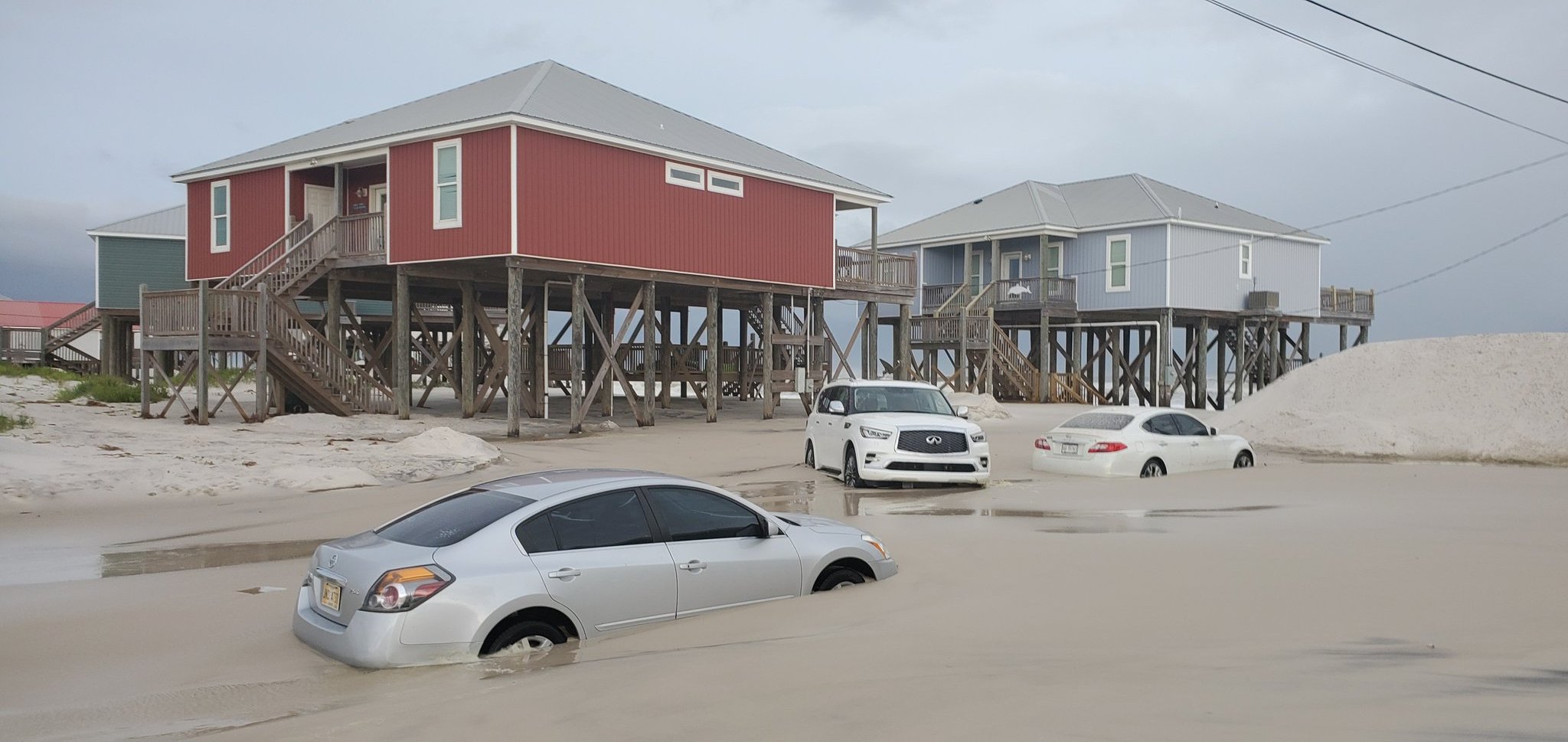
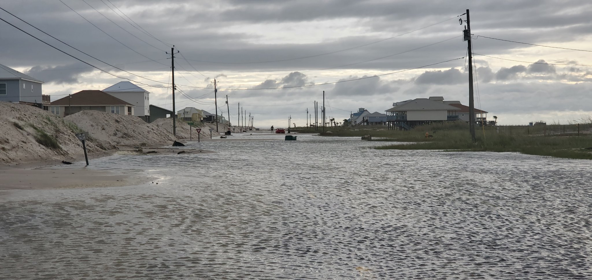
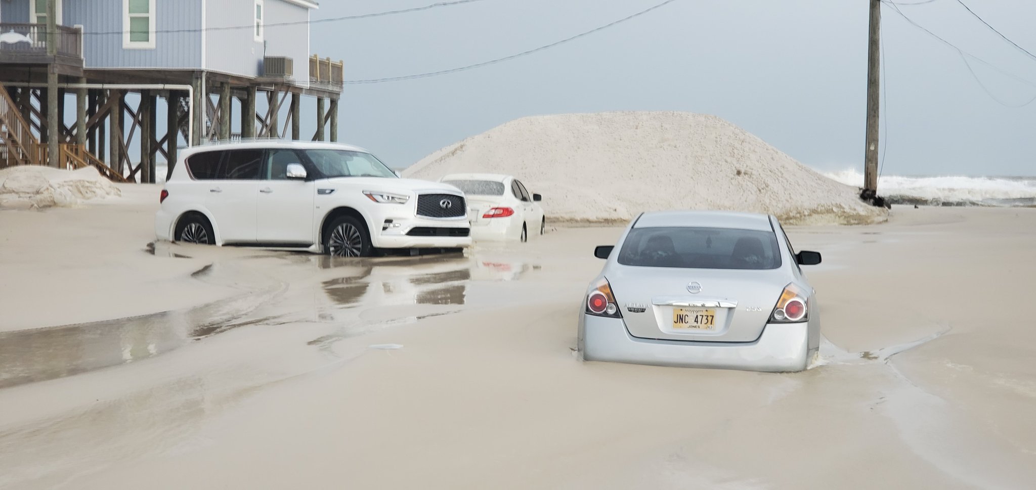
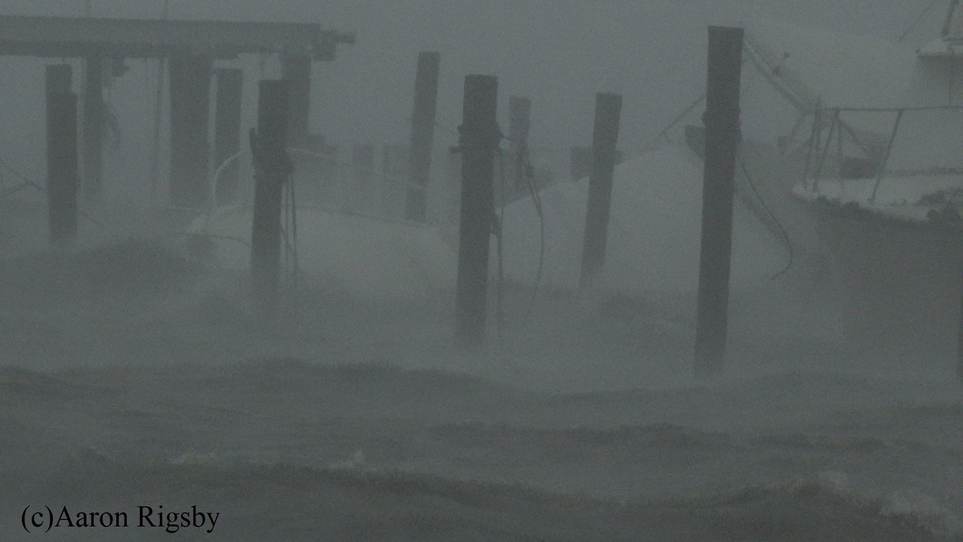
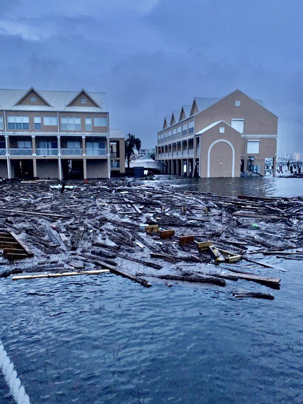
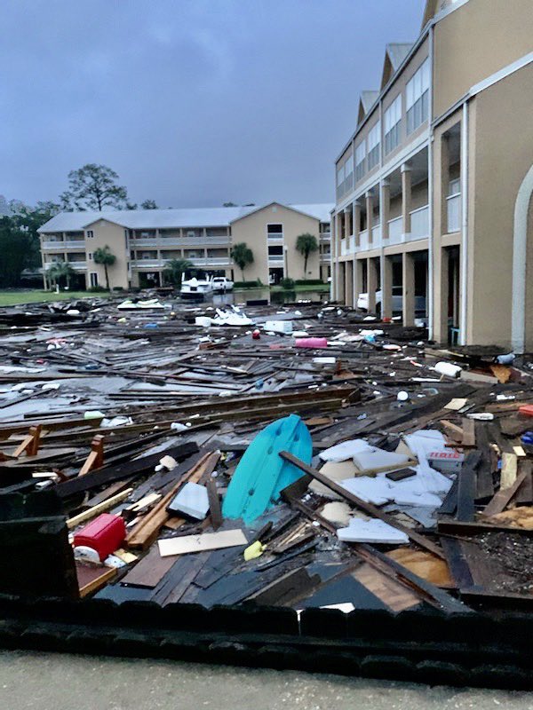
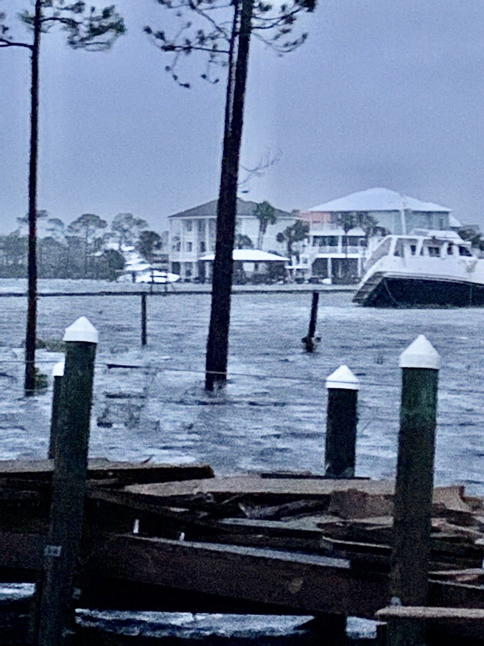
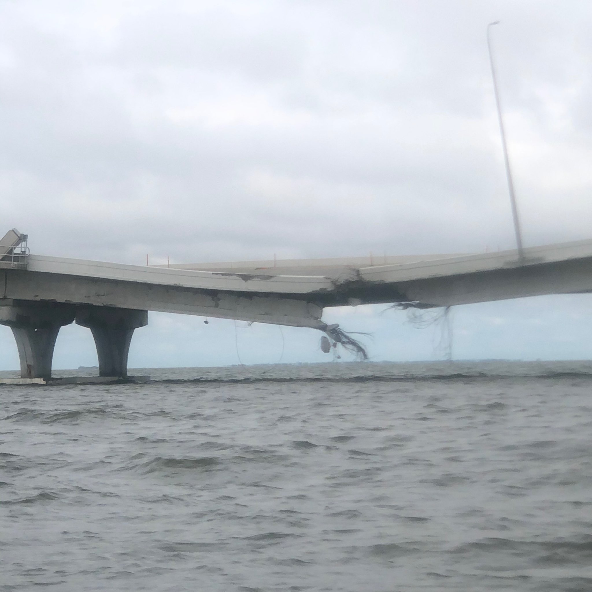
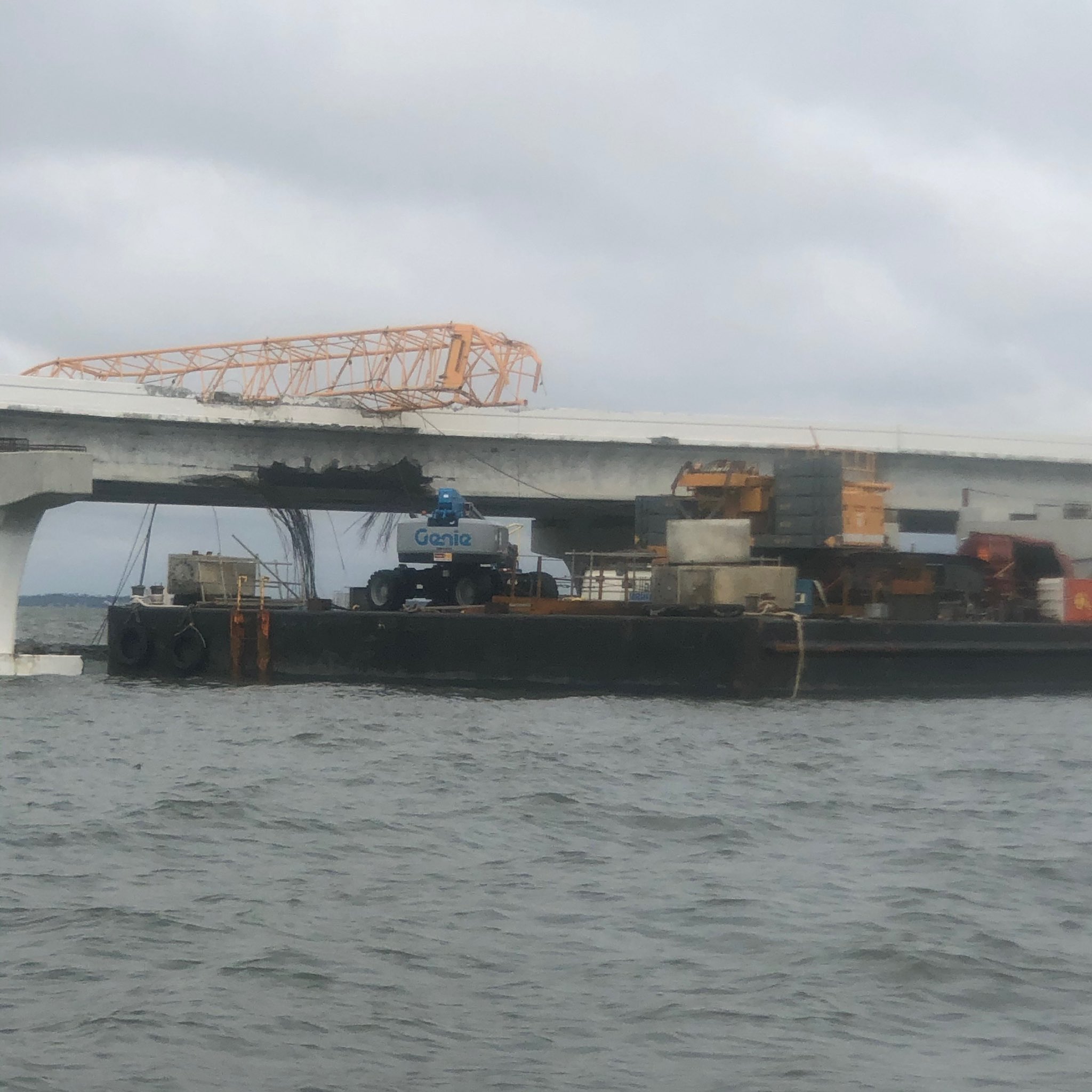
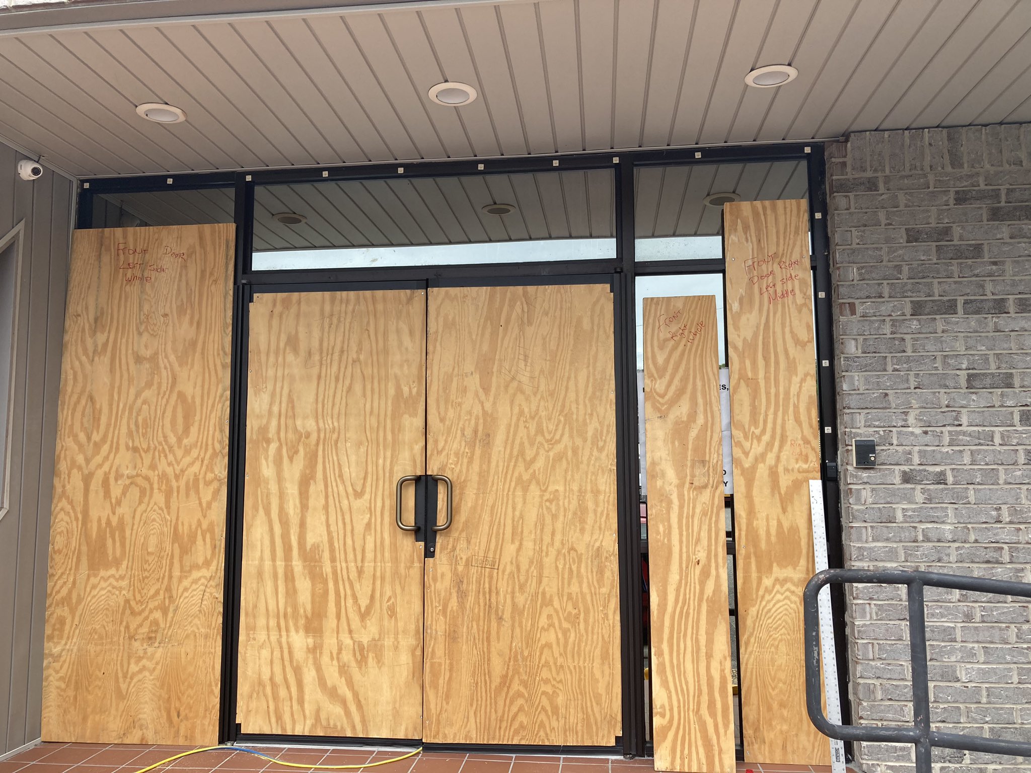
Photos from Kathryn Hendr...
OOF 6
Avatar
TJ (Houston/Galveston TX) 17-Sep-20 04:15 PM
charge the barge company for not securing the craft
this 1
Avatar
Alex V (Wausau, WI) 17-Sep-20 04:15 PM
Is Bridge x Barge 2020 Atlantic's OTP? (edited)
Avatar
Zachary S (Jasper, AL) 17-Sep-20 05:03 PM
Half a billion in damage in one little area
Avatar
Peter Potvin (Pembroke, ON) ✱ 17-Sep-20 09:22 PM
RIP Sally. Post-Tropical 😦
Avatar
ModBot BOT 17-Sep-20 09:22 PM
Archived.
Exported 1,351 message(s)