Guild icon
Stormtrack
EVENT ARCHIVE / ts-paulette-2020
Avatar
Sasha (Montreal, QC)🇨🇦 07-Sep-20 06:43 PM
Avatar
Zachary S (Jasper, AL) 07-Sep-20 07:39 PM
Getting its act together pretty nicely
Avatar
beard (fort worth) 07-Sep-20 09:47 PM
Won't do a damn thing
Avatar
Garrett (Hillsdale MI) 07-Sep-20 10:17 PM
Not so sure about this one
Avatar
Joey Prom (Lafayette, IN) 07-Sep-20 10:21 PM
Beard, you are ever so bright and optimistic... But it will do something. It will help contribute to the ACE score. Gotta beat out 2005 you know. wxtwitter
Avatar
Blaine K. (Pocatello, ID) 07-Sep-20 10:40 PM
18z HWRF says this goes nuts once it gets past the trough axis heading towards the weekend
South of Bermuda by 126h
Avatar
Ethan T. (Notasulga, AL) 07-Sep-20 10:41 PM
NHC did note a possible reintensification episode once it leaves unfavorable VWS
Other global models hold onto this possibility, along with the HWRF
Avatar
Blaine K. (Pocatello, ID) 07-Sep-20 10:44 PM
Still probably will end up OTS either way, but could get that ACE up lol
Avatar
Joey Prom (Lafayette, IN) 07-Sep-20 11:03 PM
OTS?
Avatar
Pat Kepka (Russell Co. KS) 07-Sep-20 11:03 PM
Out to sea
Avatar
Joey Prom (Lafayette, IN) 07-Sep-20 11:03 PM
aka Fish, gotcha
Avatar
Pat Kepka (Russell Co. KS) 08-Sep-20 10:18 AM
ATCF has Paulette at 65 mph now
Avatar
Zachary S (Jasper, AL) 08-Sep-20 10:24 AM
If not for increasing southwesterly shear would be a hurricane this evening
Avatar
Zachary S (Jasper, AL) 08-Sep-20 11:01 AM
Forecast peak at 70 with mention of hurricane not completely out of the question tonight before weakening
Euro is extremely aggressive longer range with a major near Bermuda
GFS basically kills it
Avatar
Zachary S (Jasper, AL) 08-Sep-20 01:45 PM
Aaaand looks like shear may be tilting it pretty big already, LLC might be at SW edge of convection
That's some rough sailing for a few days but 30kt is way more survivable than 50+
Avatar
Pat Kepka (Russell Co. KS) 08-Sep-20 01:51 PM
HWRF wants Paulette to be a naked swirl in 40 hours
Avatar
Blaine K. (Pocatello, ID) 08-Sep-20 01:54 PM
Yeah, seems like trend on that model is that is weakens (possibly down to depression), and then has it quickly strengthening again by the end of the run
Avatar
Zachary S (Jasper, AL) 08-Sep-20 02:00 PM
Wouldn't be super surprising, though will probably regenerate
It certainly won't have an easy time the next few days
Avatar
Zachary S (Jasper, AL) 08-Sep-20 11:16 PM
Forecast to drop to 40-45mph then jump back up to 65 at 120h
Avatar
Royce Sheibal (Papillion,NE) 09-Sep-20 04:00 PM
HWRF SMASH
Avatar
Zachary S (Jasper, AL) 09-Sep-20 04:01 PM
I think we can say conclusively that Paulette has potential next week
Avatar
Pat Kepka (Russell Co. KS) 09-Sep-20 08:45 PM
Avatar
Zachary S (Jasper, AL) 09-Sep-20 09:51 PM
Rather strong agreement on potential major hurricane there
Avatar
Matthew Harding (Wichita, KS) 09-Sep-20 10:11 PM
Avatar
Sasha (Montreal, QC)🇨🇦 10-Sep-20 12:39 AM
That one sub-950 going into the Bahamas is worst case scenario
Avatar
Joey Prom (Lafayette, IN) 10-Sep-20 10:40 AM
Bermuda is right in the centerline of the cone for Paulette. Forcast to be a 'Cane, per NHC (edited)
Avatar
Zachary S (Jasper, AL) 10-Sep-20 10:57 AM
Also saying their long range intensity forecast is at the low end of guidance and will probably have to be adjusted upward
Avatar
Royce Sheibal (Papillion,NE) 10-Sep-20 11:12 AM
Most of the GFS and euro ensembles like this as a major into berm. Sucks for them. It might even stall our for a few days
Avatar
Pat Kepka (Russell Co. KS) 10-Sep-20 11:16 AM
Paulette doing some weird movements this morning
Avatar
Royce Sheibal (Papillion,NE) 10-Sep-20 11:23 AM
she's got a pretty poorly stacked center, and steering winds are trailing off. she's gonna start doing weird spins, turns, circles in a couple days
Avatar
Pat Kepka (Russell Co. KS) 10-Sep-20 11:29 AM
Yeah seems like the sheared CDO keeps pulling the LLC north of track. (edited)
Avatar
Zachary S (Jasper, AL) 10-Sep-20 11:51 AM
Pretty impressively holding on for a storm in shear essentially as strong as its sustained winds
Avatar
Zachary S (Jasper, AL) 10-Sep-20 12:16 PM
Exposed center but that ain't bad
Avatar
Pat Kepka (Russell Co. KS) 10-Sep-20 01:27 PM
We are getting recon for Paulette on Saturday
Avatar
Zachary S (Jasper, AL) 10-Sep-20 01:48 PM
Awesome.
Avatar
Zachary S (Jasper, AL) 10-Sep-20 03:58 PM
Just casually throwing up -80°C lightning filled towers in 40kt shear not even too far NE of the LLC, no big deal
Avatar
Ethan T. (Notasulga, AL) 10-Sep-20 03:58 PM
Makes me wonder what’ll happen once it begins to exist unfavorable shear
It’s likely to strengthen on its approach to Bermuda, it’s the problem of how much it’ll intensify
Avatar
Zachary S (Jasper, AL) 10-Sep-20 04:01 PM
According to last forecast discussions shear should peak tonight, at dMax probably, and then begin to decrease over the next few days; so if it's made it this far and remains this robust it probably won't take that long to stack again... it's been trying to despite the shear already
Reminds me of Laura not being fazed much by the Greater Antilles and Omar casually putting along in near hurricane force shear for multiple days
Avatar
Pat Kepka (Russell Co. KS) 10-Sep-20 04:03 PM
The persistent convection also helping Paulette deviate well north and east of forecast still
Avatar
Zachary S (Jasper, AL) 10-Sep-20 04:04 PM
Might change the amount of time it's in big shear
Avatar
Pat Kepka (Russell Co. KS) 10-Sep-20 04:04 PM
It really never made the west turn that was expected so far (edited)
Avatar
Zachary S (Jasper, AL) 10-Sep-20 04:04 PM
I remember Florence decapitating itself by RI to a major and jumping north into a wall of shear in its first major hurricane segment
Avatar
Pat Kepka (Russell Co. KS) 10-Sep-20 07:48 PM
Let me introduce you to major hurricane Paulette via the 18z HWRF
Avatar
Hunter Hollman (York, PA) 10-Sep-20 08:08 PM
Oh crap, that isn't actually too far out
Avatar
Zachary S (Jasper, AL) 10-Sep-20 08:10 PM
Literally Monday
Avatar
Zachary S (Jasper, AL) 10-Sep-20 09:19 PM
Avatar
Ethan T. (Notasulga, AL) 10-Sep-20 09:19 PM
60kts max I see
Avatar
Zachary S (Jasper, AL) 10-Sep-20 09:19 PM
thonk 
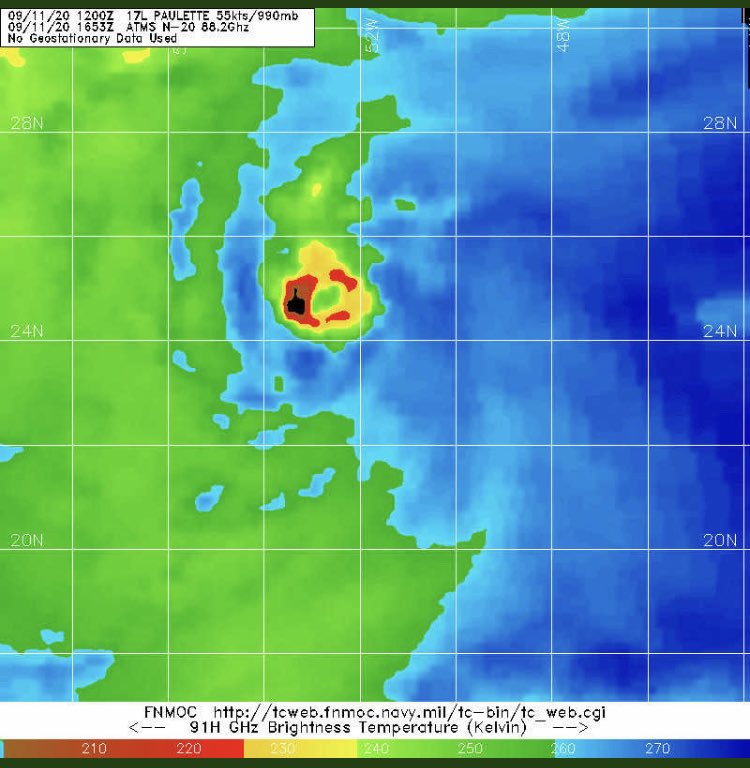
In deep convection but still
Just doesn't want to die off in the shear
Avatar
Pat Kepka (Russell Co. KS) 10-Sep-20 09:20 PM
It’s probably flagged
Avatar
Zachary S (Jasper, AL) 10-Sep-20 09:21 PM
This is absolutely gonna bomb out when it leaves shear
Avatar
Pat Kepka (Russell Co. KS) 10-Sep-20 09:22 PM
Well it’s got 48 hours of shear to go
Probably will weaken a little bit
Avatar
Pat Kepka (Russell Co. KS) 10-Sep-20 10:51 PM
Paulette now 65 mph. Peak expected to be around 105 mph now
Avatar
Alex V (Wausau, WI) 10-Sep-20 11:41 PM
So she actually intensified despite being battered with 40 knots of shear
Avatar
Ian J. (Palm Beach County, FL) 10-Sep-20 11:46 PM
maybe less intensification, more intensity was underestimated in the first place
Avatar
Royce Sheibal (Papillion,NE) 11-Sep-20 10:32 AM
one of the things we're finding this season is that slow and steady intensification in the face of bad conditions is just as hard to forecast as RI not occurring during perfect conditions
Avatar
Ethan T. (Notasulga, AL) 11-Sep-20 02:22 PM
40 knots of shear and #Paulette has a mid level eye on microwave. Very cool
Yao 3
Avatar
Pat Kepka (Russell Co. KS) 11-Sep-20 10:31 PM
Looking better
Avatar
Matthew Harding (Wichita, KS) 11-Sep-20 10:40 PM
55 kt flags in the right front quadrant
Avatar
Matthew Harding (Wichita, KS) 11-Sep-20 10:53 PM
Tropical storm watch issued for Bermuda
Avatar
B. Dean Berry (Pittsburgh PA) ✱ 12-Sep-20 02:20 AM
I've always wondered why they issue ts and hurricane watches. Like there isn't a ts or hurricane on the way, and people should look out for warnings. Just issue the warnings!
Avatar
Alex V (Wausau, WI) 12-Sep-20 02:24 AM
Why do we issue winter storm watches, severe thunderstorm watches, and tornado watches?
Same reason.
Avatar
Ethan T. (Notasulga, AL) 12-Sep-20 03:53 AM
Paulette, what are you doing??
Avatar
Joey Prom (Lafayette, IN) 12-Sep-20 07:40 AM
?
Avatar
Zachary S (Jasper, AL) 12-Sep-20 06:16 PM
Recon is in there right now
Huge wind field and microwave shows well defined core
Avatar
Pat Kepka (Russell Co. KS) 12-Sep-20 06:30 PM
Recon finding a beast of a storm.
78 knots Flight level and still increasing on the WEAK side. Dang
Avatar
Zachary S (Jasper, AL) 12-Sep-20 06:32 PM
I get the feeling Paulette has been a little stronger than thought for its whole track, what a beast
Avatar
Ian J. (Palm Beach County, FL) 12-Sep-20 06:36 PM
I thought so when we got 60kt flagged barbs on an ASCAT pass days ago
Avatar
Zachary S (Jasper, AL) 12-Sep-20 06:42 PM
982mb
Probably find a hurricane in NE quad
Avatar
Pat Kepka (Russell Co. KS) 12-Sep-20 06:53 PM
And it did not surprisingly
Avatar
Zachary S (Jasper, AL) 12-Sep-20 06:56 PM
Shouldn't take too long if convection gets healthier as shear falls
Rather low pressure for a TS
Avatar
Jim Martin (Findlay, Ohio) 12-Sep-20 07:01 PM
Paulette still seems to be a bit lopsided for now
Avatar
Zachary S (Jasper, AL) 12-Sep-20 07:54 PM
Still under about 20kt
Avatar
Pat Kepka (Russell Co. KS) 12-Sep-20 07:58 PM
It’ll take a little bit to vertically align
Avatar
Ethan T. (Notasulga, AL) 12-Sep-20 08:14 PM
Pressure down to 981.7mb
Really low for a 55-60kt system in my opinion
Avatar
Alex V (Wausau, WI) 12-Sep-20 08:17 PM
It's probably been a hurricane for half a day
Avatar
Ian J. (Palm Beach County, FL) 12-Sep-20 08:18 PM
I mean, drops and SFMR don't support a hurricane rn
The low pressure can be explained by the massive windfield
Avatar
Ian J. (Palm Beach County, FL) 12-Sep-20 08:44 PM
Latest drop in the SE quad arguably supports a hurricane (edited)
73kt in the lowest 150m, surface winds of 66kt
Avatar
Zachary S (Jasper, AL) 12-Sep-20 08:46 PM
Once it finishes stacking should be good to go
Avatar
Ian J. (Palm Beach County, FL) 12-Sep-20 08:49 PM
Best track up to 65kt (cat 1)
Avatar
Pat Kepka (Russell Co. KS) 12-Sep-20 10:42 PM
Hurricane #Paulette Advisory 25: Paulette Now a Hurricane. Strong Winds and Heavy Rain Expected to Begin On Bermuda By Sunday Evening. https://t.co/VqHn0u1vgc
Avatar
Garrett (Hillsdale MI) 13-Sep-20 12:02 AM
New peak is 110mph
Avatar
Nate O. (DFW - Wylie, Texas) 13-Sep-20 12:12 AM
Gonna be a big ace maker but not good for Bermuda
Avatar
Sasha (Montreal, QC)🇨🇦 13-Sep-20 01:25 AM
Avatar
Zachary S (Jasper, AL) 13-Sep-20 03:21 AM
Always amazing how many storms in the big ol Atlantic manage to directly hit tiny speck Bermuda
Avatar
Max (Saint John, NB) 13-Sep-20 07:11 AM
^ always makes me think too
Avatar
Jacob Melton (Owosso, MI) 13-Sep-20 11:17 AM
Well there's the M...
Avatar
Hunter Hollman (York, PA) 13-Sep-20 11:35 AM
Yikes
Reminiscent of Humberto of last year
Avatar
Nate O. (DFW - Wylie, Texas) 13-Sep-20 02:52 PM
Glad it goes major after Bermuda and not before
Avatar
Zachary S (Jasper, AL) 13-Sep-20 03:44 PM
Avatar
Zachary S (Jasper, AL) 13-Sep-20 07:38 PM
Recon's in there
976mb in the eyewall so far, has intensified significantly
Avatar
Parker Hughes (McKinney, Tx) 13-Sep-20 07:55 PM
Out in the Atlantic, #Paulette is within view of radar imagery out of #Bermuda. The system's outer bands are impacting the island now while the core remains about 200km offshore. Still expecting the eye of Paulette to pass over or very near Bermuda later tonight. https://t...
getting in range of the radar in Bermuda
Avatar
Zachary S (Jasper, AL) 13-Sep-20 08:33 PM
Very impressive looking storm but looks like a bit of dry air is keeping impressive FL winds from mixing down according to sondes/SFMR, good for Bermuda that surface winds aren't as high as they look for that appearance/pressure but of course could ramp up in the next few hours if the eyewall closes off
Avatar
Calvin Thomas (Mizzou, MO) 13-Sep-20 10:50 PM
Bermuda has a really nice radar page
Here's a 0.6 tilt velocity product
Avatar
Glen Heinz (Greenville, SC) 13-Sep-20 11:24 PM
Nice Calvin, that eye is just hours away.
Avatar
Pat Kepka (Russell Co. KS) 14-Sep-20 03:11 AM
Internet communications with the Bermuda Weather Service have been disrupted due to a possible island-wide power outage. Only cell phone service is available.
62 mph sustained and 89 mph gust was the last airport measurement
96 mph gust was recorded on the island earlier
Avatar
Nate O. (DFW - Wylie, Texas) 14-Sep-20 08:46 AM
Just got an update from Minister of National Security @reneemingbda. No major issues have been reported overnight 🙏🏾
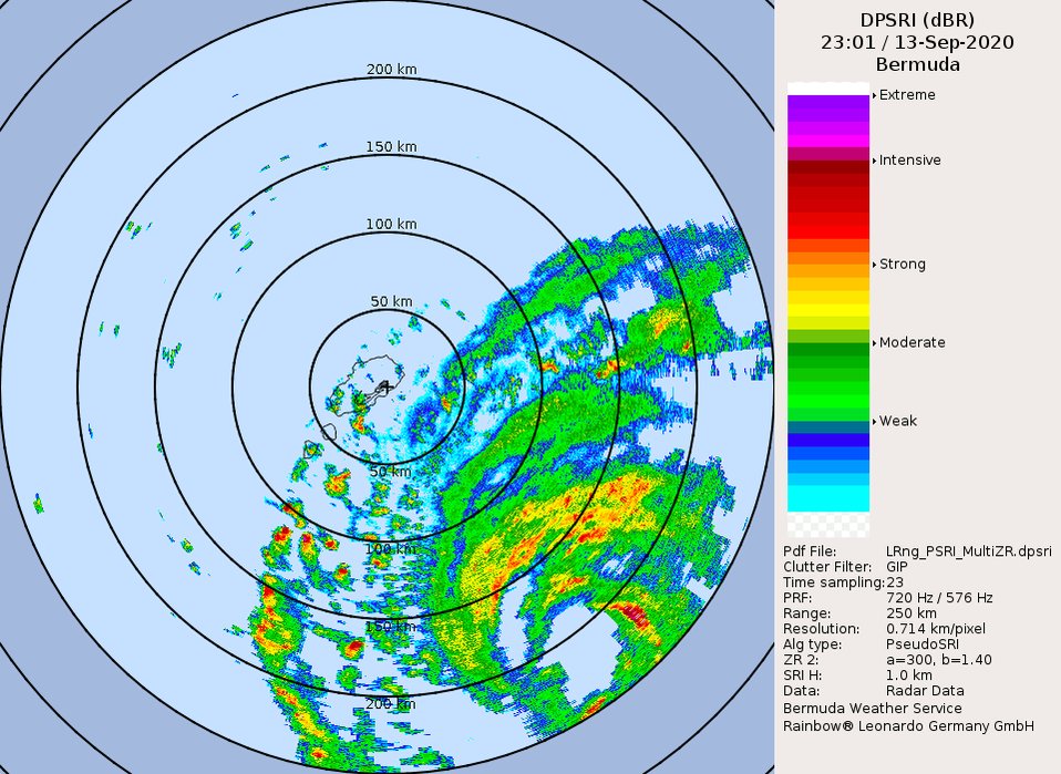
. The eye of #HurricanePaulette passed directly over the island as a Category 1 storm and we are now in the 2nd half of the storm. #StaySafeBermuda -DB
Avatar
Glen Heinz (Greenville, SC) 14-Sep-20 08:59 AM
Wow good to hear.
Avatar
Zachary S (Jasper, AL) 14-Sep-20 03:18 PM
Looking really good
Looks like a lock for major, even the 110kt seems possible with trough interaction
Avatar
Ethan T [FBI] (Odessa, DE) 15-Sep-20 10:49 PM
Paulette could redevelop further down the line
Avatar
Jacob Melton (Owosso, MI) 16-Sep-20 10:44 AM
Avatar
Joey Prom (Lafayette, IN) 16-Sep-20 10:46 AM
So does this mean it stops contributing ACE points?
Avatar
B. Dean Berry (Pittsburgh PA) ✱ 22-Sep-20 07:38 PM
It's back.
Avatar
Avatar
James K (Jeffco, Colorado) 22-Sep-20 09:59 PM
I guess in that last advisory, they should have let the storm give a final quote: "I'll be back" LOL. Think if it had come back around & far enough south to form into a 'real' storm... Has that ever actually happened?
Avatar
Pat Kepka (Russell Co. KS) 22-Sep-20 10:01 PM
Ivan 2004 might be what you are looking for
Avatar
Pat Kepka (Russell Co. KS) 22-Sep-20 10:37 PM
Post-Tropical Cyclone #Paulette Advisory 44: Paulette Becomes a Post-Tropical Cyclone For the Second Time. https://t.co/VqHn0u1vgc
And it gone
Exported 145 message(s)