Guild icon
Stormtrack
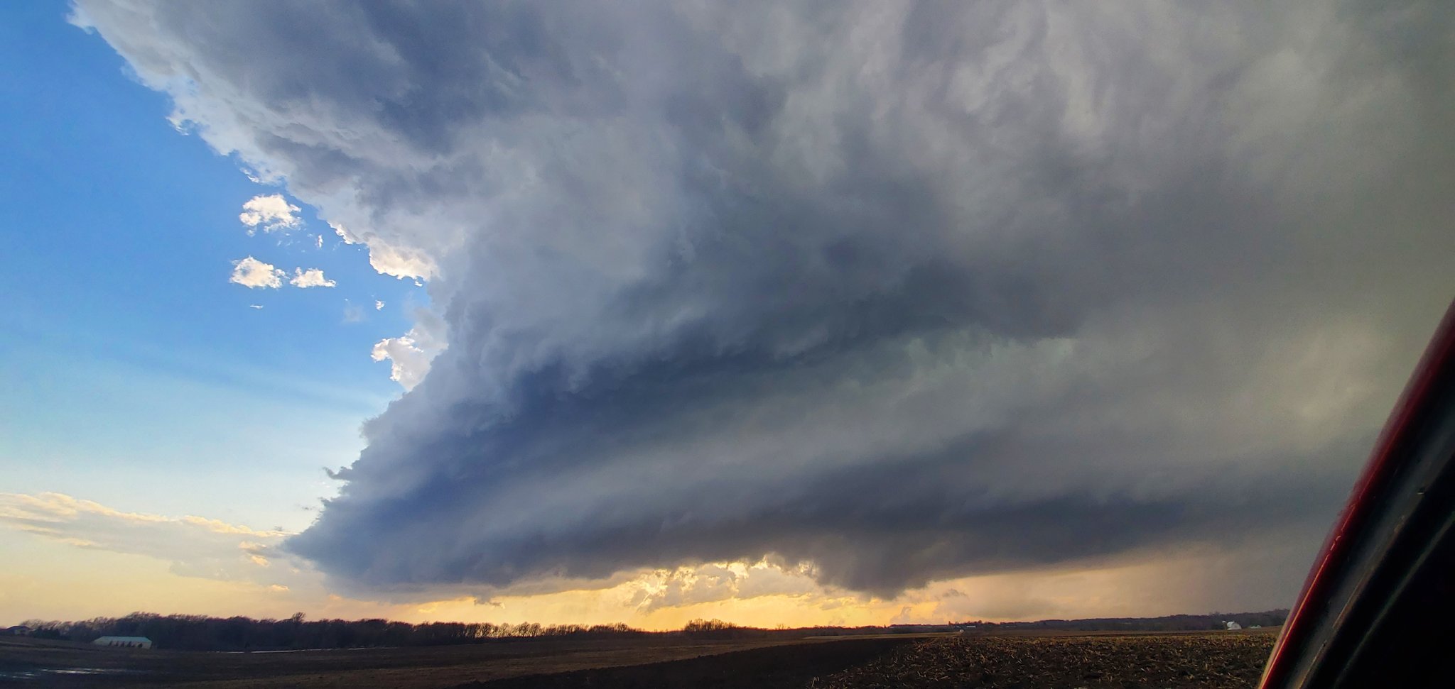
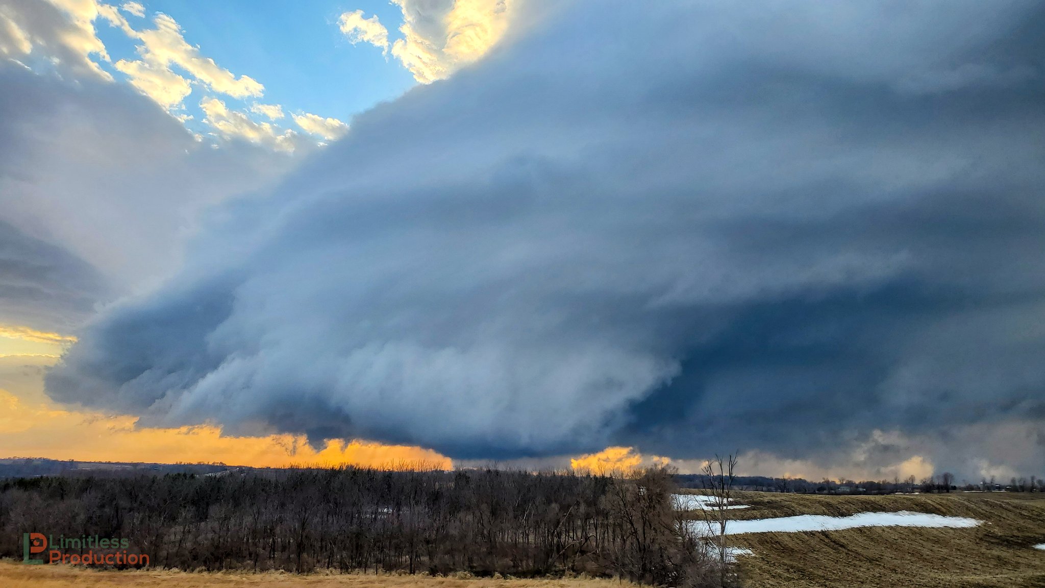
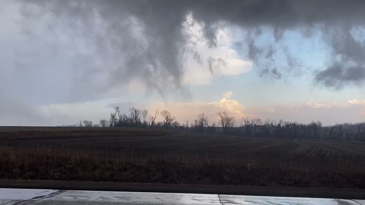
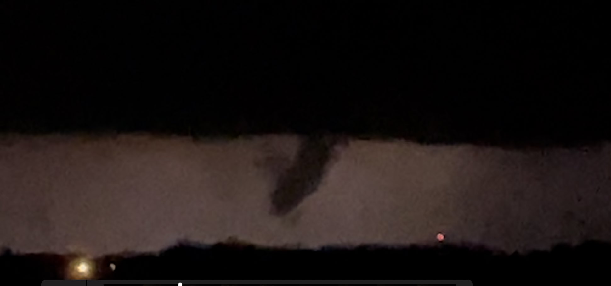
EVENT ARCHIVE / 03-10-2021_ks_ok_mo_mn_wi_ia
Avatar
Glen Heinz (Greenville, SC) 09-Mar-21 04:52 AM
Tornado
Wind
Hail
Thoughts concerns please post away.
Arm-chair chasing is allowed! If I was to chase this day, I would go here and this is why.... (edited)
Avatar
Glen Heinz (Greenville, SC) 09-Mar-21 05:09 AM
Capping, Hail and Elevated. My issues with this system event. Per Broyles.
A hail threat may also develop further to the south across central and northern Oklahoma, but a capping inversion there will make the threat more conditional. An isolated wind damage threat may also develop with this convective cluster. However, most of the storms will be elevated which should keep any wind damage threat marginal.
Avatar
Palmer (Weld County, CO) 09-Mar-21 11:37 AM
The OK cluster doesn't seem elvated to me. I'm more bullish than the SPC on that area based on the soundings I'm pulling from there. Cap seems broken by 00z.
Avatar
Palmer (Weld County, CO) 09-Mar-21 12:11 PM
Anyone see a reason to be more pessemistic?
Avatar
Joey Prom (Lafayette, IN) 09-Mar-21 12:36 PM
Ask Shane, thats his default state
Avatar
Palmer (Weld County, CO) 09-Mar-21 12:40 PM
@Shane Adams (Fort Worth, TX)
Avatar
Shane Adams (Fort Worth, TX) 09-Mar-21 01:26 PM
It's called "realistic."
I haven't looked at tomorrow. I'm not chasing.
Avatar
Glen Heinz (Greenville, SC) 09-Mar-21 01:39 PM
I would local chase it or be on the ready to jump in and go. Other then that I wouldn't be going from state to state.
Avatar
Lee S (Wichita, KS) 09-Mar-21 01:40 PM
Looks like I’ll be in the county eoc for this versus chasing.
Avatar
Glen Heinz (Greenville, SC) 09-Mar-21 01:41 PM
lol your in it man.
Avatar
B. Dean Berry (Pittsburgh PA) ✱ 09-Mar-21 01:44 PM
Fun times
Avatar
Payton (Lawrence, KS) 09-Mar-21 01:47 PM
I think I'll keep an eye out since I've been wanting to get out and chase
Avatar
Glen Heinz (Greenville, SC) 09-Mar-21 02:53 PM
seeing more like hailers and elevated. Then after this the next day Moisture is going to be the problem.
Maybe will get a surprise tube? Nah... Not that lucky.
Avatar
Royce Sheibal (Papillion,NE) 09-Mar-21 04:23 PM
RAP/HRRR/NAM showing some 1-2 STP values in W IA. doesnt seem like alot, but the runs keep nudging slower and slower with better moisture convergence
if the RAP confirms we could end up with a 55-60 TD warm sector /w a very solid vort max just to the west. with 60 kts of bulk shear some mini-supers are definately possible.
again this all depends on how badly the warm sector gets smooshed / dries out. a really dry push at 850 could cap the entire thing until dark
IOWA 2
Avatar
Glen Heinz (Greenville, SC) 09-Mar-21 04:32 PM
yeah capping, moisture and heating will it be enough? Grungefest with hailers. (edited)
Avatar
Royce Sheibal (Papillion,NE) 09-Mar-21 04:33 PM
latest SREF is VERY progressive overnight, with minimum thresholds at 40% for severe over nebraska by midnight. with an MCS possible running into iowa
Avatar
Glen Heinz (Greenville, SC) 09-Mar-21 04:33 PM
Hell I can be wrong. I wouldn't mind being wrong.
Avatar
Royce Sheibal (Papillion,NE) 09-Mar-21 04:34 PM
yeah the profile isn't great for chasing if IA does confirm, further south in KS/OK i'm not impressed, the vort max is pretty far away
Avatar
Glen Heinz (Greenville, SC) 09-Mar-21 04:35 PM
yeah it's a local chase at best or keep your car out of it.
I'll get a look at 00z GFS
Avatar
Royce Sheibal (Papillion,NE) 09-Mar-21 04:36 PM
yeah when SCP are 9-12 but stps are only 1-2. hail party is no fun
Avatar
Glen Heinz (Greenville, SC) 09-Mar-21 04:36 PM
agreed my dude.
Avatar
Royce Sheibal (Papillion,NE) 09-Mar-21 04:37 PM
that being said, days like this in march do often crap out little EF0-1 bull moving 60mph. omaha had a couple touchdowns a couple marches ago with similar scenario
NAM was over-progressing the low and it held back an extra 1-2 hours, just long enough to get into a negative tilt setup
Avatar
Glen Heinz (Greenville, SC) 09-Mar-21 04:41 PM
hmmm, yep March. They are Finke , very. Geez one month this wouldn't be a bad to go out. Wouldn't be a break out. Would have been stay out the hail. Look for the spinning Thunderhead and watch for tubes.
One month more heating of gulf and this event.
This also might be a hint of what we will be dealing with later on? (edited)
Avatar
Joey Prom (Lafayette, IN) 09-Mar-21 04:46 PM
as far as upper level winds? (edited)
Avatar
Glen Heinz (Greenville, SC) 09-Mar-21 04:49 PM
there's flow.
lcl is high 700ish. ops (edited)
well 750 to 700.
700mb RH hmm not good.
I think storms will get going after dark. Will be capped.
if your desperate for storms local chase or practice.
North of Elk City any takers? lol
@Joey Prom (Lafayette, IN) yep there it is.
Avatar
John Choquette (Edmond, OK) 09-Mar-21 05:12 PM
probably gonna be a good first chase with the new truck for the news station tmrw
Avatar
Joey Prom (Lafayette, IN) 09-Mar-21 05:14 PM
I am hoping to knock the rust off and break in a new chasing buddy on Thursday here in IN or IL. The question is will we even get storms of some kind?
Avatar
Glen Heinz (Greenville, SC) 09-Mar-21 05:19 PM
I wouldn't be expecting much. Maybe a good lightning show after dark? @John Choquette (Edmond, OK) Yeah kick the dust off and chase the hailers after dark. (edited)
More like up your ally for your team and company. lol
Avatar
John Choquette (Edmond, OK) 09-Mar-21 05:20 PM
yup lol
Avatar
Glen Heinz (Greenville, SC) 09-Mar-21 05:20 PM
lol enjoy just for you guys.
Avatar
Royce Sheibal (Papillion,NE) 09-Mar-21 08:14 PM
large scale climatology patterns favor a VERY active early season. we'll see how it goes
the la nina into neutral shift plus the teleconnection phases looking good. only drawback is the gulf is very cool. will limit the northside
Avatar
Glen Heinz (Greenville, SC) 09-Mar-21 08:28 PM
yeah what is the gulf water temps? Since that COld blast?
Avatar
Royce Sheibal (Papillion,NE) 09-Mar-21 08:42 PM
whatever color blue is, so cold AF
18zNAM followed the rap and slows it down agian. squall line starts right over OMA now. HRRR speeds it up and has dry line thru OMA by 17z
Avatar
Joey Prom (Lafayette, IN) 09-Mar-21 08:50 PM
Right near the coast its cold, but most of the gulf is already pretty warm.
Avatar
Royce Sheibal (Papillion,NE) 09-Mar-21 08:50 PM
latest RAP is very quick tomorrow. has some good STP into N IA. who's ready for some LIOWA tricks?
that gulf eddy gonna be just S of texas ina bout 2 months. juicy
Avatar
Joey Prom (Lafayette, IN) 09-Mar-21 08:52 PM
Moisture potential will not be a problem this year, just like last year. However, if we get good moisture return is an open question
Avatar
Royce Sheibal (Papillion,NE) 09-Mar-21 08:53 PM
last year we had some stupid zonal flow. merdional was not happening below 700mb
Avatar
Joey Prom (Lafayette, IN) 09-Mar-21 08:54 PM
2020 was weird...
Avatar
Royce Sheibal (Papillion,NE) 09-Mar-21 09:00 PM
OMA's 2020 was the driest since the dust bowl. outside of a couple good early spring rains / fall rains it was dead dry. let's hope 2021 doesn't repeat
1 tornado watch in OMA all year. 1. and it was a dud. srsly
Avatar
Drew Terril (Yukon, OK) 09-Mar-21 09:18 PM
interesting contrast because in Oklahoma, my lawn mower got more use than it has in a long time. Never really got dumped on all at once, but the frequency kept the grass growing faster than I could knock it down.
Avatar
Pat Kepka (Russell Co. KS) 09-Mar-21 09:32 PM
It was MCS galore here halfway in between
Avatar
Glen Heinz (Greenville, SC) 09-Mar-21 10:09 PM
trollowa
Avatar
TJ (Houston/Galveston TX) 09-Mar-21 11:32 PM
Never count out iowa for the hail mary tornado. Always when you least expect it, or when you think there isn't a chance. I missed a tornado by a few hours, because we already have up on a sloppy day storm.
Avatar
Vince Waelti (Rockford, IL) 10-Mar-21 08:10 AM
^ 5%
Avatar
TJ (Houston/Galveston TX) 10-Mar-21 08:11 AM
Going to be interesting to see what the morning rain does to the environment today. (editedYao )
Avatar
Vince Waelti (Rockford, IL) 10-Mar-21 08:11 AM
Lol here comes Iowa with the trollnado
Avatar
Norman Smith (Racine, OH) 10-Mar-21 08:29 AM
RAP near Rochester, MN
Avatar
Royce Sheibal (Papillion,NE) 10-Mar-21 08:35 AM
The dry line and warm sector have been super progressive. Dry line clearing omaha already. (Low of 61 this morning here). The HRRR really liked N IA last night
Avatar
Vince Waelti (Rockford, IL) 10-Mar-21 08:35 AM
I was planning chasing today-Sunday in KS/OK/TX just for funsies. I stayed home in case Liowa pulls something today. Kind of glad I did
Avatar
Royce Sheibal (Papillion,NE) 10-Mar-21 10:31 AM
Strong moisture convergence along the triple point and warm front into NW IA. Should advect NE over the day. Low td t spreads. Even a little cape could set off some mini supercells. Tor chances looking ok
Avatar
Joey Prom (Lafayette, IN) 10-Mar-21 11:29 AM
WHAT!!! MN steals tornado show in March. wtf. Wish I had taken a trip home to visit my folks...
Thompson has his hand in it too, dang
Avatar
Joey Prom (Lafayette, IN) 10-Mar-21 11:39 AM
Damn, HRRR is very consistent in painting a scary looking Helicity track right over the SE corner of the metro. A lot of good people live there. Likely not expecting severe weather this early. If we get tornados today it would not break the record, but would only be 4 days after the earliest recorded tornado in MN. But that was only set very recently (2017). The previous record which stood for half a century was March 18th. Man, I wish I was back home!!!
Avatar
Joey Prom (Lafayette, IN) 10-Mar-21 11:56 AM
Just need cloud breaks to spike those lapse rates
Avatar
Royce Sheibal (Papillion,NE) 10-Mar-21 01:06 PM
BUY BUY BUY
several WRF models and the RAP both agree with HRRR. we've got CAM convergence
several 63/63 td/t station plots comign in with a solid Q field.
RAP meso shows pocket of 1200+ cape already forming just E of omaha, should overspread the warm sector in a couple hours. 45-50mph gusts here near OMA. the low level hodos are gonna be BLASTING
one concern, BRN shear numbers are near 150, that's too high for good supercell formation. will tend toward mutli-cellular, but with that much SRH even a transient mini-super could drop a tor
Avatar
Joey Prom (Lafayette, IN) 10-Mar-21 02:02 PM
HRRR keeps showing a Helicity track just south east of the metro between 6 - 8 pm, tracking into WI. If that shifts just 1 county N, we could be in some trouble
Avatar
Jacob Melton (Owosso, MI) 10-Mar-21 02:38 PM
Avatar
Joey Prom (Lafayette, IN) 10-Mar-21 03:00 PM
do we go 10% hatched for MN tornados with 20z update?
Avatar
Vince Waelti (Rockford, IL) 10-Mar-21 03:04 PM
No
Avatar
Joey Prom (Lafayette, IN) 10-Mar-21 03:06 PM
Yea, looks like they kept it at 5%. I am guessing they re skeptical of the moisture. Its conditional, but I think still very possible to get a sig tor out of this, just given what the CAMs are showing.
My Point, the HRRR has been showing basically the same thing for 8+ runs in a row. Now its showing even a few more.
Avatar
Drake Anthony (Peoria, IL) 10-Mar-21 03:10 PM
that would be pretty wild if it played out that way since this setup is not favored by climo lol
Avatar
Joey Prom (Lafayette, IN) 10-Mar-21 03:12 PM
All the CAPE is 0 - 3km. Very large shear.
Climo is pretty far up the 'ol ladder from mesoscale. And the Meso/Synoptic scale are all for this event, which is due to start in 1 - 2 hours
Big shock, Reed agrees with my desire to go enhanced, lol.
Avatar
Royce Sheibal (Papillion,NE) 10-Mar-21 03:25 PM
this is a highly conditional, but enhanced potential day IMHO
i'd give this a 10% non-hatched
with a very high bust factor
Avatar
Royce Sheibal (Papillion,NE) 10-Mar-21 03:40 PM
several of my early spring chases in E NEB come to mind. high shear, low cape, high bust, 10% worthy days. broke my chase partner's tornado cherry on a day like this in april
Avatar
Ed Tierney (Oak Lawn, IL) 10-Mar-21 03:46 PM
A tornado watch has been issued for parts of Iowa, Minnesota and Wisconsin until 8 PM CST
Avatar
Jacob Melton (Owosso, MI) 10-Mar-21 03:47 PM
40/20
Avatar
Royce Sheibal (Papillion,NE) 10-Mar-21 03:53 PM
i like the SW edge near fort dodge. the stuff up near mankato is too transient. unless it can get a cell to split hard right you wont get anything
fort dodge target is closest to the triple point and max mass convergence
high wind warning for non-storm gusts to 60mph in SW IA/SE NE
wow. that target is moving fast. the cells/ dryline clockin around 60mph?
if you squint real hard there is a weak meso on the cell 30 mi south of MSP
strcutures still appear to be very trasient. most tops <30k feet.
Avatar
Glen Heinz (Greenville, SC) 10-Mar-21 04:14 PM
well that went from troll to yes it's happening.
Avatar
Royce Sheibal (Papillion,NE) 10-Mar-21 04:36 PM
i think we still may be in troll mode. look at the cells. all left split dominant. moving N away from the inflow. they are just gonna cycle forever.
starting off the midwest season with an IA/MN bust in early march. very 2021
Avatar
Norman Smith (Racine, OH) 10-Mar-21 04:37 PM
Still to early to call it a bust tbf
I think a few of these cells could become dominant
That one near Judson, MN looks interesting
Avatar
Jacob Melton (Owosso, MI) 10-Mar-21 04:42 PM
Heads up Waseca, MN this thing is turning into a beast. Ground scraping inflow @NWSTwinCities
Avatar
Norman Smith (Racine, OH) 10-Mar-21 04:42 PM
Why hello
Avatar
Royce Sheibal (Papillion,NE) 10-Mar-21 04:52 PM
if anything can hold up for more than 15 minutes and get some right turn, it will be ready to rock.
Avatar
Joey Prom (Lafayette, IN) 10-Mar-21 04:53 PM
HRRR wants that 2 happen 5 - 7 central. been saying that for 12 hours straight. all according to plan so far
Avatar
Vince Waelti (Rockford, IL) 10-Mar-21 04:53 PM
I’m sitting in Alberta Lea waiting it out. Defiantly good clearing and warming
this 1
Avatar
Joey Prom (Lafayette, IN) 10-Mar-21 04:54 PM
I am so jealous man!
Avatar
Jim Martin (Findlay, Ohio) 10-Mar-21 04:54 PM
that storm near Fairbault will be crossing into air temperatures in the 40s...
Avatar
Norman Smith (Racine, OH) 10-Mar-21 04:55 PM
Just saying look at next Wednesday 👀
Avatar
Joey Prom (Lafayette, IN) 10-Mar-21 04:55 PM
is GFS back to showing it?
Avatar
Norman Smith (Racine, OH) 10-Mar-21 04:55 PM
Y u p
Avatar
Jacob Melton (Owosso, MI) 10-Mar-21 04:55 PM
3:45pm CST #SPC_MD 0151 , #mowx #kswx #newx #okwx, https://t.co/koofMI3UfR
Avatar
Joey Prom (Lafayette, IN) 10-Mar-21 05:05 PM
Latest HRRR run backs off a bit. Pushes those bigger cells later and into WI more.
Avatar
Royce Sheibal (Papillion,NE) 10-Mar-21 05:11 PM
some fresh smol boys on the south side of the line. looking very good
Avatar
Glen Heinz (Greenville, SC) 10-Mar-21 05:12 PM
better the hell up times a wasting now.
this window will close in couple hrs at BEST.
Avatar
Royce Sheibal (Papillion,NE) 10-Mar-21 05:13 PM
cells near waterville, east of new prague have pretty clear mesos forming on base vel
Avatar
Glen Heinz (Greenville, SC) 10-Mar-21 05:13 PM
bingo
Avatar
Royce Sheibal (Papillion,NE) 10-Mar-21 05:13 PM
waterville cell has the "eagle look"
Avatar
Glen Heinz (Greenville, SC) 10-Mar-21 05:14 PM
MN tor wanring
i think Mike's on it of course? (edited)
Avatar
Royce Sheibal (Papillion,NE) 10-Mar-21 05:14 PM
i hope mike is on it. that ZDR is INTENSE right now
Avatar
Glen Heinz (Greenville, SC) 10-Mar-21 05:15 PM
nope i found him he's way South (edited)
@Holden(MN) has a chance
red red
red shirts
lol
Avatar
Royce Sheibal (Papillion,NE) 10-Mar-21 05:16 PM
3 cells in a row on that convergence line, all 3 have very solid small mesos
mesos don't exist very far up in the cells, these are def mini-supercells, textbook
Avatar
Ed Tierney (Oak Lawn, IL) 10-Mar-21 05:17 PM
Yeah that cluster for a minute had 3-4 hooks trying to form
Lonsdale, Cannon City, and north of Waterville
Avatar
Royce Sheibal (Papillion,NE) 10-Mar-21 05:19 PM
that mapleton area cell looks fire
cell heading toward apple valley looking steady. good sig on vel despite ugly dbz
apple valley cell showing ZDR curved signature. here we go
Avatar
James T. (NW OH) 10-Mar-21 05:25 PM
Marz is on the new tornado warned cell
Janesville is about to do it
Avatar
Ed Tierney (Oak Lawn, IL) 10-Mar-21 05:27 PM
Yeah that looks good
Avatar
Glen Heinz (Greenville, SC) 10-Mar-21 05:28 PM
Mike's on that one
@Mike Ma☈z (Minneapolis, MN) GO MIKE! GET IT!
Avatar
James T. (NW OH) 10-Mar-21 05:29 PM
Out bound just died
Did that get chocked off
Avatar
Royce Sheibal (Papillion,NE) 10-Mar-21 05:29 PM
gusted out, inbound flaired out wide
Avatar
James T. (NW OH) 10-Mar-21 05:30 PM
That was my second guess
Avatar
Royce Sheibal (Papillion,NE) 10-Mar-21 05:30 PM
early season storms like this love to gust out just like that. my first chase did the same thing RFD'ed into golfballs
Avatar
Jeff House (Chattanooga, TN) 10-Mar-21 05:30 PM
Cell is near or on the triple point. Probably in a spot to produce, perhaps cycle, if cold air does not undercut after one or two. Or before any.. (edited)
Avatar
Norman Smith (Racine, OH) 10-Mar-21 05:32 PM
Woah new role colors!
Looks like new circulation is developing to the south on that tornado warned cell
Avatar
Jeff House (Chattanooga, TN) 10-Mar-21 05:34 PM
LOL I think the roles line up with SPC colors. Anyway we’ll see if that cell can recover. It’s on the TP but the cold air is March cold.
Avatar
Royce Sheibal (Papillion,NE) 10-Mar-21 05:34 PM
these puppies got beaver tails /w strong inbounds on them
tail end charley looks like it cycled pretty fast. new meso happening
Avatar
Glen Heinz (Greenville, SC) 10-Mar-21 05:37 PM
Wat we wouldn't do such a thing now would we? lol
😆 1
pds 1
Avatar
Royce Sheibal (Papillion,NE) 10-Mar-21 05:37 PM
amazing how the convergence all got squeeze into that little band there. to the SE and into IA looks like CIN may be holding on.
Avatar
John Choquette (Edmond, OK) 10-Mar-21 05:38 PM
neat im red now
Avatar
Tristan White (Hartselle, AL) 10-Mar-21 05:38 PM
Lol im the SLGT risk yellow
Avatar
Glen Heinz (Greenville, SC) 10-Mar-21 05:40 PM
you know what they say about the red shirts? lol
Spann 2
this 2
Avatar
Royce Sheibal (Papillion,NE) 10-Mar-21 05:41 PM
MET's are dispensable i guess. wait. does this mean admin's are higher than a high? The mythical, legendary, unspoken, "very high"?
Avatar
Glen Heinz (Greenville, SC) 10-Mar-21 05:42 PM
lol
nice royce
Avatar
James T. (NW OH) 10-Mar-21 05:45 PM
Castle Rock might be the next one
Avatar
Peter Potvin (Pembroke, ON) ✱ 10-Mar-21 05:48 PM
Admins are going to be the same colour as Mods, as per #announcements. Just gotta wait for that to be changed as I don't have access to change Admin colour.
Avatar
Jeff House (Chattanooga, TN) 10-Mar-21 05:49 PM
I like being Moderate. Best chase days! Anyway both the southern cell and middle one are hanging on in Minn. TV showed a brief touch down with dust on the ground about 10 minutes ago I think with the middle one. Second hand report so no pic or screen shot. (edited)
Avatar
James T. (NW OH) 10-Mar-21 05:49 PM
Current view west of Medford, MN. #mnwx
Avatar
Norman Smith (Racine, OH) 10-Mar-21 05:50 PM
Good luck to the chasers going out to the SE MN are today! My hypothetical target area would be around Fairbault, MN.
Here’s a nice aged tweet
Avatar
James T. (NW OH) 10-Mar-21 05:58 PM
Another rotating supercell near Faribault Minnesota
Avatar
Norman Smith (Racine, OH) 10-Mar-21 06:06 PM
O my
Avatar
James T. (NW OH) 10-Mar-21 06:06 PM
That is literally a plains type supercell
Avatar
James T. (NW OH) 10-Mar-21 06:22 PM
@NWSTwinCities looking west at 135th St E and Hall Ave. Trained Spotter. #mnwx
Avatar
James T. (NW OH) 10-Mar-21 07:18 PM
Avatar
Joey Prom (Lafayette, IN) 10-Mar-21 07:20 PM
Definitely violently rotating... 🤪
Avatar
TJ (Houston/Galveston TX) 10-Mar-21 07:31 PM
oldman
Avatar
Justin | @Helicity (NOLA) 10-Mar-21 11:55 PM
Filmed a funnel cloud five miles NE of Chanute KS at 10:25 PM. @NWSWichita #kswx
Til the last drop (edited)
👀 2
Exported 191 message(s)