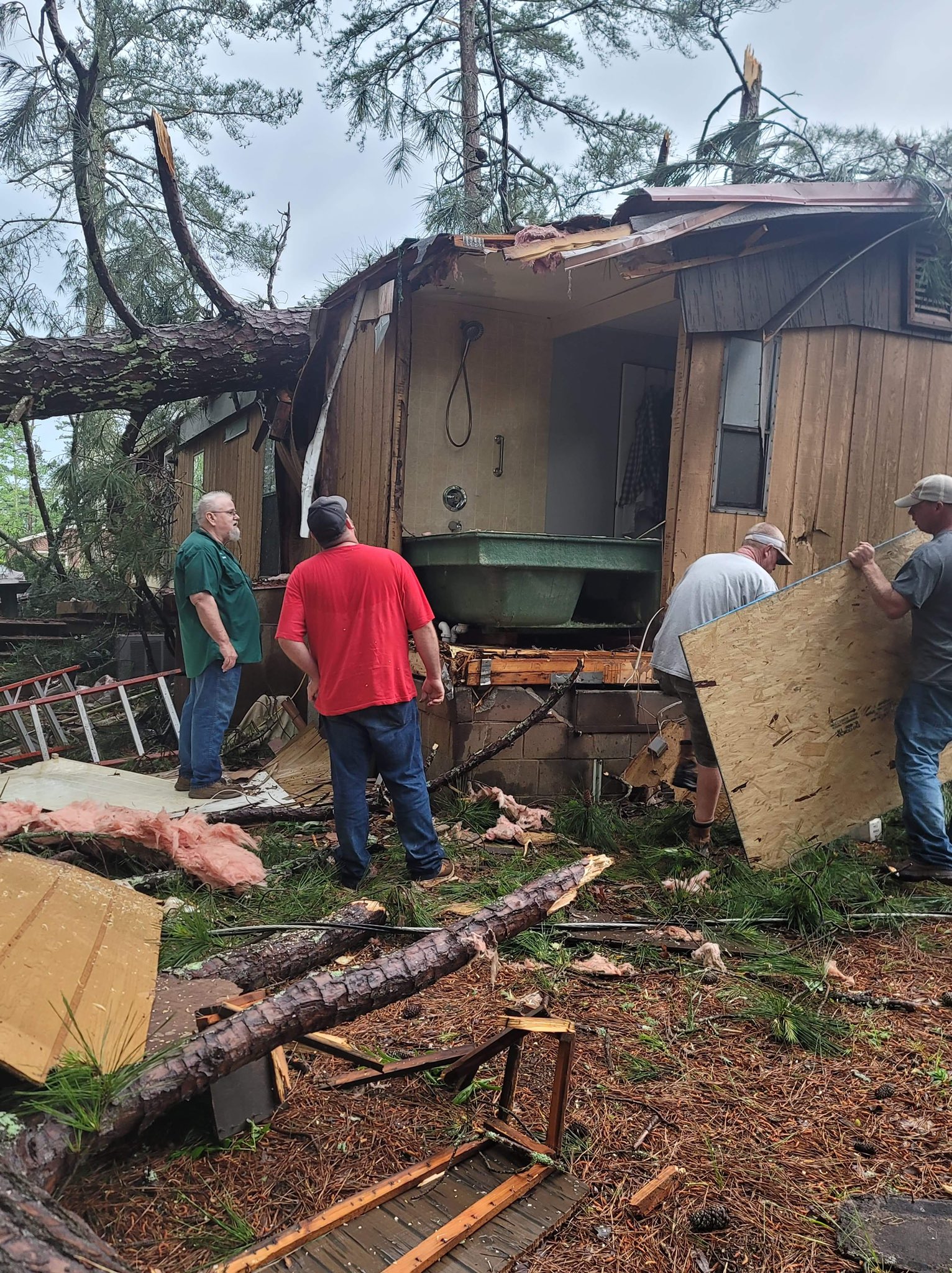
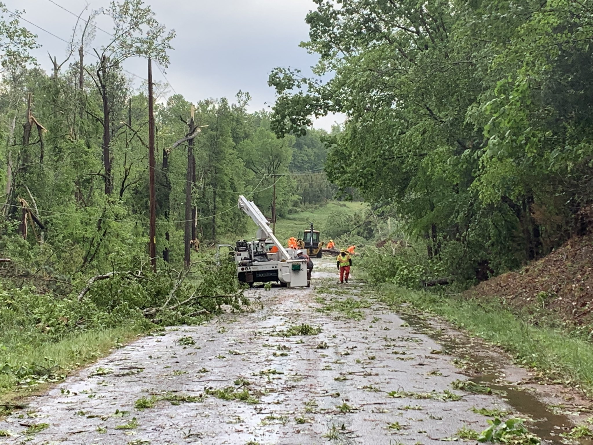
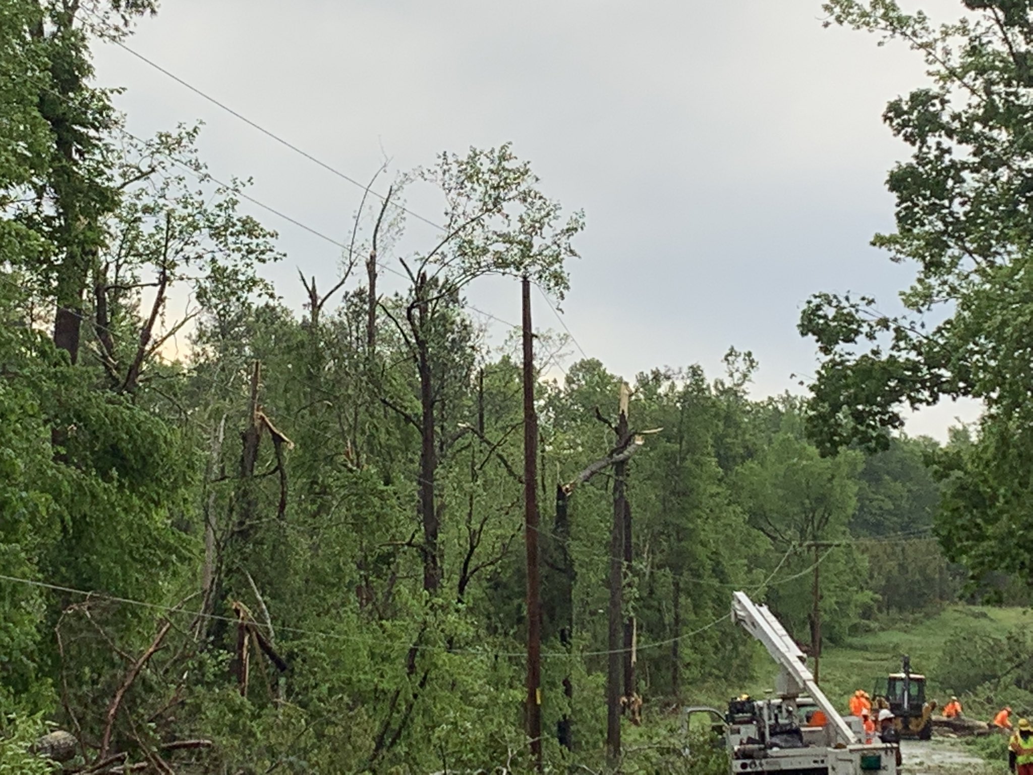
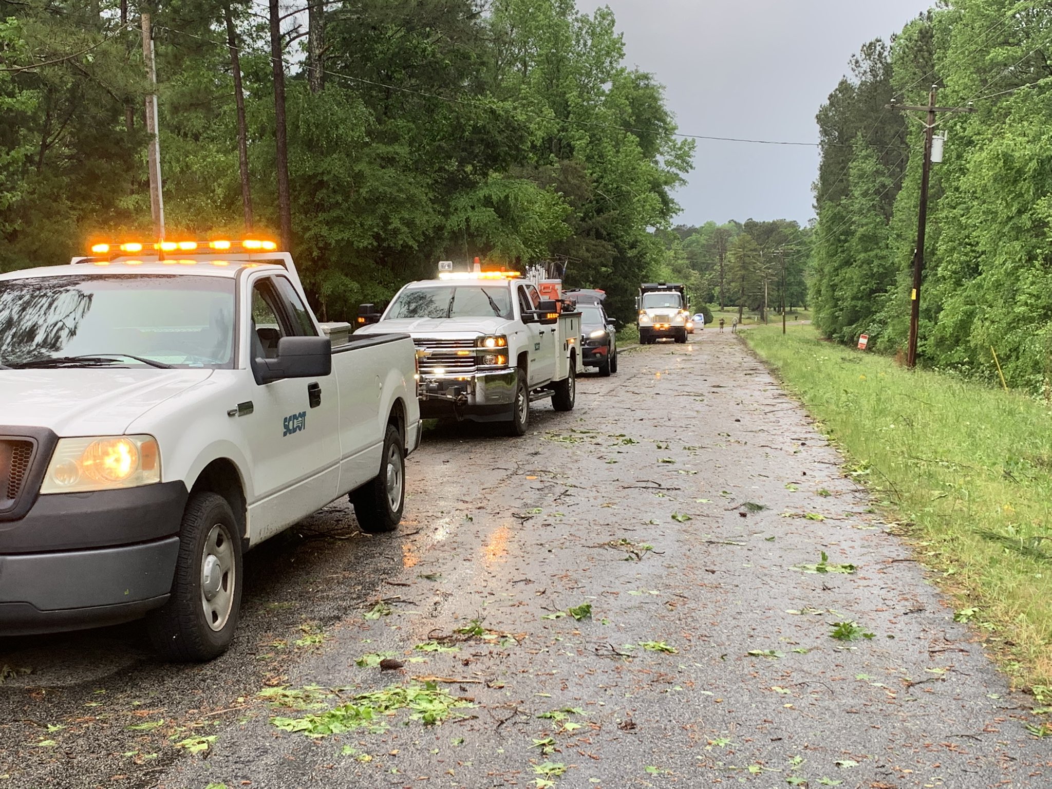
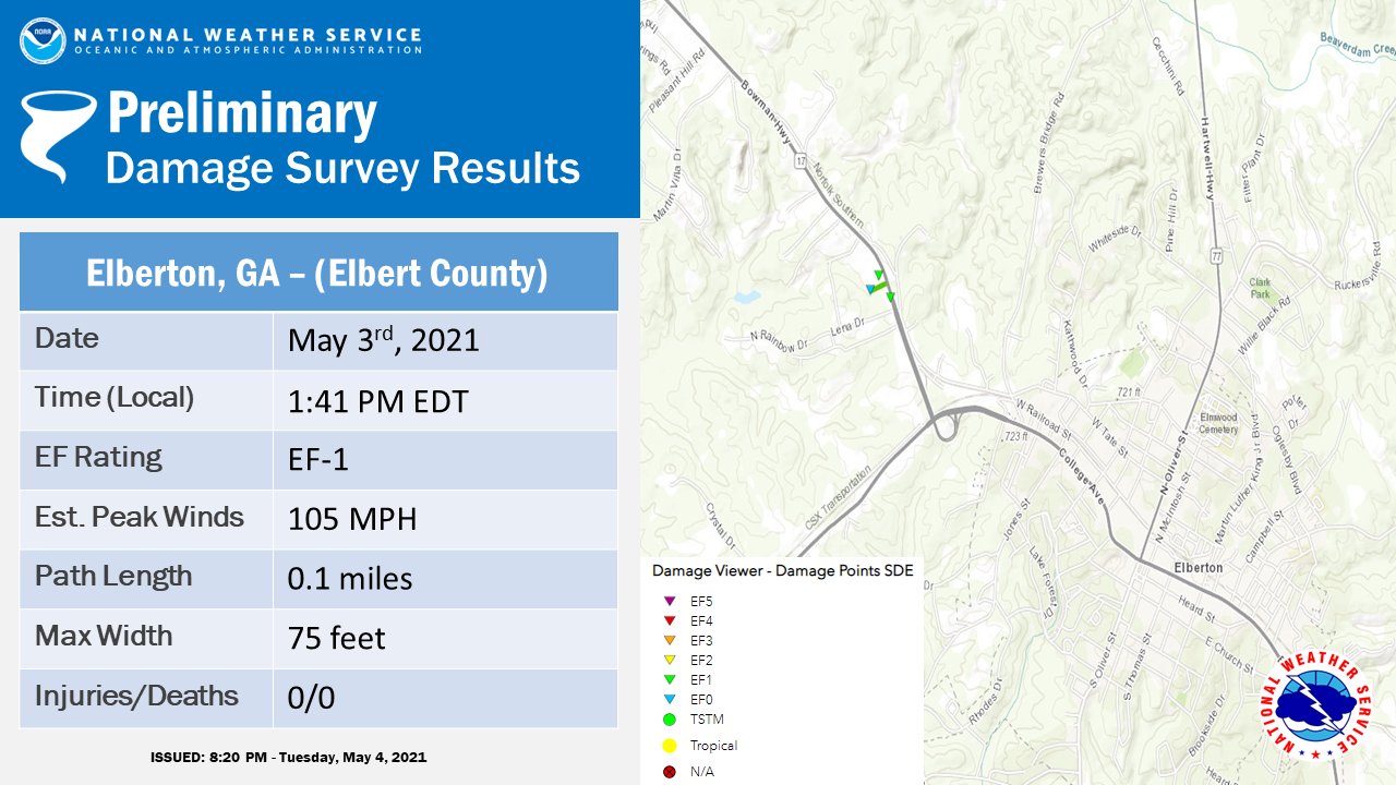
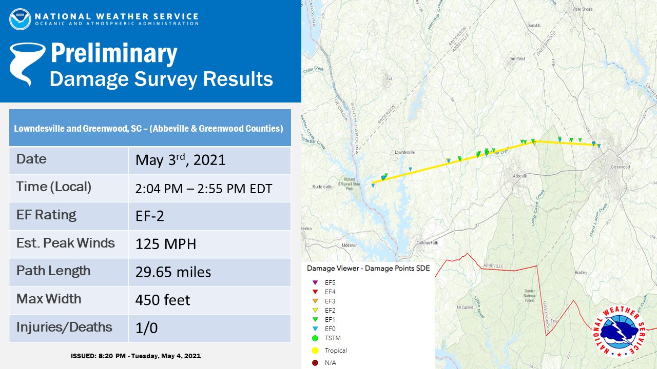
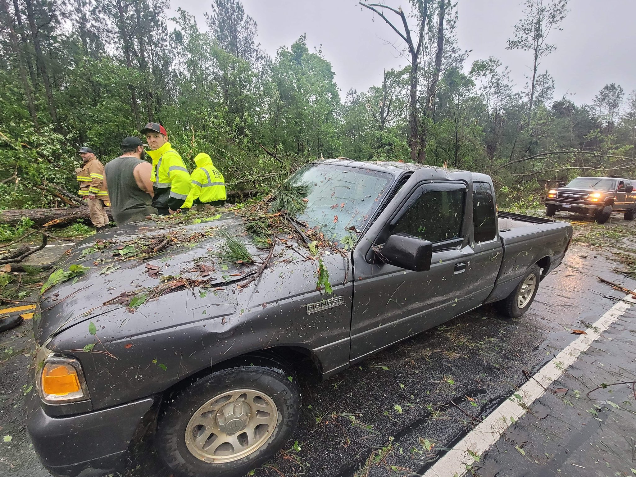
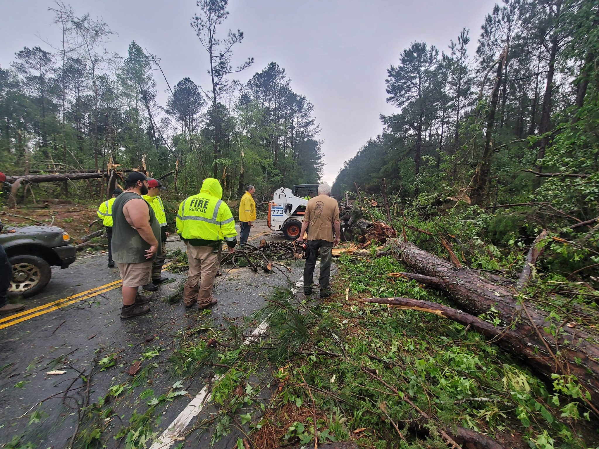
Guild icon
Stormtrack
EVENT ARCHIVE / 05-03-2021_ar_ks_ky_il_in_oh_ok_mo_tn
Avatar
Peter Potvin (Pembroke, ON) ✱ 02-May-21 10:43 AM
Categorical
5% Tornado
15% hatched wind and hail
Models indicate that a belt of westerlies across the northern mid-latitude Pacific may undergo considerable amplification during this period. It appears that this will include a building mid-level ridge axis to the west of the British Columbia/Pacific Northwest coast, while broader ridging across the southern mid-latitude/subtropical eastern Pacific begins to shift inland of the California coast and Baja. As this occurs, initially amplified downstream troughing is forecast to progress east-northeastward out of the Four Corners states.
Avatar
Matthew Gaylor (OKC, OK) 02-May-21 10:45 AM
Personally think we could see a tornado or two in the 5% at sunset with the LLJ Until then though, these things are going to line out quickly.
Low level backing lacks until the jet kicks in, and even worse, start to become parallel to the front.
Avatar
Lucas Munzlinger (Dittmer,MO) 02-May-21 10:55 AM
I'm acully having trouble picking out a target area for this one, (Missouri) I'm thinking this event will be a pick an area on Monday Morning. look at the observations too
Avatar
Eddie Natenberg (Albany, NY) 02-May-21 10:58 AM
Well this looks nothing like the NAM NEST (which shows a bust): (edited)
Avatar
Payton (Lawrence, KS) 02-May-21 11:23 AM
Yeah I'm having trouble with that too. I'm thinking I'm gonna go Mid Missouri (do not want to go to Arkansas or Southern Missouri.) or NE Oklahoma but not seeing anything to make me pick one over the other.
Avatar
Brad (Carthage, MO) 02-May-21 12:26 PM
I’m aiming for Arkansas and then I can always stay with them as they work their way north and east
A day out watching clouds is better than nothing.
Avatar
Lucas Munzlinger (Dittmer,MO) 02-May-21 12:37 PM
I was just thinking that too!
Avatar
Ed Tierney (Oak Lawn, IL) 02-May-21 01:34 PM
Not if those clouds don't do much 😉
Avatar
Payton (Lawrence, KS) 02-May-21 01:35 PM
Also if I'm skipping some classes to do this, not really an issue but would rather spend my time being productive than driving through Missouri for nothing
Avatar
Payton (Lawrence, KS) 02-May-21 01:44 PM
Tor probs expanded a ton
Avatar
Peter Potvin (Pembroke, ON) ✱ 02-May-21 01:45 PM
Sock puppet lol
😆 1
Avatar
Norman Smith (Racine, OH) 02-May-21 01:59 PM
Tuesday looks WAY better
Avatar
Joey Prom (Lafayette, IN) 02-May-21 02:03 PM
Yea, they bumped everything north to account for the N IL squall line/potential derecho (imo)
Avatar
Brad (Carthage, MO) 02-May-21 02:27 PM
Change of plans. I’m taking my fishing pole in case things bust like they did last time on me. I’m not sure if it looks too promising
Avatar
Joey Prom (Lafayette, IN) 02-May-21 02:38 PM
It does, but I believe its contingent on Monday performing as modeled. If we get lots of storms, that may stall the moisture advection. Or if the Cold front surges instead of stalls that would wash it out too.
Avatar
Norman Smith (Racine, OH) 02-May-21 02:42 PM
I agree to a degree....think it just depends on what time the impact would be on
Idk how I feel about Monday tbh
Regardless more storms could lead to more boundaries laid out
Kinda scared for Tuesday if pans out
Avatar
Avatar
Norman Smith (Racine, OH) 02-May-21 02:53 PM
Trailers and trees don’t go good together
Avatar
Payton (Lawrence, KS) 02-May-21 04:17 PM
The NAM is not liking this event
Avatar
Eddie Natenberg (Albany, NY) 02-May-21 04:17 PM
HRRR showing rapid development in NE OK Monday evening, NAM shows cap bust except near/north of the warm front in MO. I’m surprised theres no consensus. (edited)
Avatar
Payton (Lawrence, KS) 02-May-21 04:30 PM
I was hoping to be able to decide where and whether I was gonna chase by today but with them disagreeing like they are I have no clue what I'm gonna do. (edited)
Avatar
Brad (Carthage, MO) 02-May-21 04:54 PM
with this showing a storm in my area I think I'm going to go out and see if it amounts to anything. I want to test out my new camera anyway. The model run earlier looked more promising than it does now though
Avatar
Payton (Lawrence, KS) 02-May-21 04:56 PM
The HRRR is making me lean towards Oklahoma but I don't know if I want to put all my trust in it.
Avatar
Brad (Carthage, MO) 02-May-21 05:05 PM
I have issue with the timing. the cell moving into our area is showing 8pm. I'm considering heading a little farther west myself
Avatar
Payton (Lawrence, KS) 02-May-21 05:07 PM
Same. That's also making me question if I want to go, don't really want to drive 4-5 hours to get a storm after dark.
Avatar
Brad (Carthage, MO) 02-May-21 05:12 PM
my thinking is if I can get it right as it's starting to fire off and get in behind it, it might make a cool sunset picture and then stay with it as it moves north and east so i don't get hit with any surprises
Avatar
Joey Prom (Lafayette, IN) 02-May-21 06:02 PM
The next 2 days could be huge, or nothing may happen. I would not put much stock in the CAMs atm. Its really going to come down to the placement of the Cold front and if the advecting moisture/EML is as strong as modeled.
Avatar
Eddie Natenberg (Albany, NY) 02-May-21 06:50 PM
Its an erratic setup with the upper level forcing, I think the main energy may come in after dark. I prob wouldn’t chase unless I was desperate to see something, possibly after dark in OK/MO. Still more focused on the week after. (edited)
Avatar
Payton (Lawrence, KS) 02-May-21 07:02 PM
I haven't chased since last year so I'm pretty desperate but not 5 hours for a cell in the dark desperate. This year has really been a letdown after last years dismal season. I'm probably gonna go out next week if we get something closer but I've got finals and of course that's the week things start picking up.
However, I could end up going tomorrow since I can afford to miss the classes I have tomorrow so I wouldn't really be losing anything but my time and gas money. (edited)
Avatar
Eddie Natenberg (Albany, NY) 02-May-21 09:51 PM
Well the latest 00z HRRR is breaking the cap earlier
Avatar
Payton (Lawrence, KS) 02-May-21 09:53 PM
I saw that, I'm gonna wait for the 00z nam to see if it has changed it's mind. (edited)
Avatar
Joey Prom (Lafayette, IN) 02-May-21 09:54 PM
I am wondering if we might get a derecho in N IL tomorrow?
Avatar
Eddie Natenberg (Albany, NY) 02-May-21 09:57 PM
I just told my parents they will.
Avatar
Payton (Lawrence, KS) 02-May-21 09:58 PM
it's may 3rd all over again
🤦‍♂️ 5
Avatar
Eddie Natenberg (Albany, NY) 02-May-21 10:10 PM
Is this based off Climo or CAM? 😜
Avatar
Payton (Lawrence, KS) 02-May-21 10:11 PM
it's gonna be 20 years isn't it?
also a contaminated sounding, so i didn't share the rest of it
CONTAMINATED 2
Avatar
Joey Prom (Lafayette, IN) 02-May-21 10:22 PM
Great chance for Sprites
Avatar
Josh Zitko(St Louis, MO) 03-May-21 01:17 AM
D2 out before the D1, guess they're thinking on it
Avatar
Jacob Melton (Owosso, MI) 03-May-21 01:58 AM
Welp... (30% SIG Wind driven)
Avatar
Josh Zitko(St Louis, MO) 03-May-21 01:58 AM
5% TOR expanded a bit
Avatar
Lucas Munzlinger (Dittmer,MO) 03-May-21 08:57 AM
You gonna be chasing local today?
Avatar
Joey Prom (Lafayette, IN) 03-May-21 10:02 AM
With me
Avatar
Josh Zitko(St Louis, MO) 03-May-21 10:16 AM
@Lucas Munzlinger (Dittmer,MO) somewhere in illinois along that 5 is where we've been looking. Glad to see they expanded it north
Avatar
Royce Sheibal (Papillion,NE) 03-May-21 11:15 AM
Anyone chasing IL today? Seems like a low key but high upside chase.
Avatar
Joey Prom (Lafayette, IN) 03-May-21 11:17 AM
Yes. Josh and I
We will be leaving St. Louis between 2 and 2:45
Avatar
Josh Zitko(St Louis, MO) 03-May-21 11:24 AM
@Drake Anthony (Peoria, IL) Looks like could be a local target for you, planning on going out?
Avatar
Royce Sheibal (Papillion,NE) 03-May-21 11:25 AM
Strong theta e ridge over E IA and the river. Good moisture conv. Over NE Mo. That should advect east into W IL. Tough target day.
Avatar
Royce Sheibal (Papillion,NE) 03-May-21 11:33 AM
Of course. OK into NW AR and MO looks really interesting today. Massive convergence ahead of the low. High capes today. Shear isn't great but I still expect a ton of action down there
Avatar
Drake Anthony (Peoria, IL) 03-May-21 11:41 AM
Yeah I'll be out later today that's for sure. I'd be happy with a healthy dose of lightning at this point
Avatar
Josh Zitko(St Louis, MO) 03-May-21 11:41 AM
Pretty much my perspective haha (edited)
Avatar
Matthew Gaylor (OKC, OK) 03-May-21 11:42 AM
Triple point in OK would be my hypothetical target for OK chasers.
I doubt I get out today.
Avatar
Eddie Natenberg (Albany, NY) 03-May-21 11:52 AM
Well the HRRR is moving things slowly west. Maybe the ecmwf was right all along, its like NWP bingo. And it sounded like it when they start doing bullet points on D1 outlooks.
Avatar
Matthew Davies (Poteau, OK) 03-May-21 12:29 PM
10% hatched in SE OK
Avatar
Royce Sheibal (Papillion,NE) 03-May-21 12:31 PM
Sounds like they listened to my forecast lol
Dallas VAD looking ideal
Avatar
Josh Zitko(St Louis, MO) 03-May-21 12:41 PM
Welp, should've called OK a day ago I guess haha
Illinois is backyard though
Avatar
John Choquette (Edmond, OK) 03-May-21 12:43 PM
Heading for the southern Oklahoma target shortly
Avatar
Matthew Gaylor (OKC, OK) 03-May-21 12:44 PM
Nice. Sulpher area?
Avatar
Royce Sheibal (Papillion,NE) 03-May-21 12:45 PM
Sorry if repost.
Spann 3
this 2
Avatar
John Choquette (Edmond, OK) 03-May-21 12:47 PM
Yeah sulpher area
Avatar
Jacob Metzger (Fort Worth, TX) 03-May-21 12:48 PM
just gonna go out on the roof of my job and watch storms from here lol
Avatar
Matthew Gaylor (OKC, OK) 03-May-21 12:51 PM
That’s what I would target. I just don’t know that I’ll have time and not sure I want to chase that area today with traffic.
Avatar
Cody D. (Lincoln, NE - UNL) 03-May-21 12:51 PM
isn't there supposed to be holes in that roof right now? Lol
Avatar
Tristan White (Hartselle, AL) 03-May-21 12:52 PM
15Z HRRR definitely has discrete sups by like 6-7 pm. Biggest question is how long they can remain discrete and will upscale growth occur quickly? We shall see.
Avatar
Matthew Gaylor (OKC, OK) 03-May-21 12:52 PM
Dallas getting another hailstorm today. Oof
Avatar
John Choquette (Edmond, OK) 03-May-21 12:59 PM
long enough for dfw to get smacked again and my tuesday is busy
Avatar
Jacob Metzger (Fort Worth, TX) 03-May-21 01:16 PM
Surprisingly, no. That monster hailcore missed my house by a mile or so
Avatar
Royce Sheibal (Papillion,NE) 03-May-21 01:55 PM
Avatar
Palmer (Weld County, CO) 03-May-21 02:04 PM
With the current surface temps and dewpoints, I'm surprised it hasn't already popped off in north texas
Avatar
Drake Anthony (Peoria, IL) 03-May-21 02:30 PM
My current plan is to chase either along I74 or US136 in central IL today. Thankfully this is local so I can wait until storms are firing until making a move
I hope the clearing trend over W IL continues
Avatar
Payton (Lawrence, KS) 03-May-21 02:34 PM
I would get out before they fire, everytime we've waited until they fire off we are too far to actually make it in time.
Avatar
Josh Zitko(St Louis, MO) 03-May-21 02:35 PM
I don't think the models predicted this much clearing, should give a bit more of a boost to thermals
Avatar
Josh Zitko(St Louis, MO) 03-May-21 03:06 PM
If storms can hold together in Illinois, might be a chance
Avatar
Vince Waelti (Rockford, IL) 03-May-21 03:07 PM
Location on that sounding?
Avatar
Josh Zitko(St Louis, MO) 03-May-21 03:09 PM
@Vince Waelti (Rockford, IL) sorry, I'm one to call people out for that usually lol. Near Arthur Illinois
Avatar
Vince Waelti (Rockford, IL) 03-May-21 03:09 PM
no i was just wondering because Im down near peoria chasing and haven't checked models for awhile
Avatar
Josh Zitko(St Louis, MO) 03-May-21 03:11 PM
Yeah, I'm about to head up that way
Avatar
Matthew Gaylor (OKC, OK) 03-May-21 03:13 PM
There’s the meso for the watch that will soon come.
Avatar
Matt Luttrell (Norman, Oklahoma) 03-May-21 03:18 PM
HRRR makes it look like our Oklahoma storms may fire just before 8pm 7pm (edited after most recent run). And civil twilight is 8:18pm. So an hour and half of decent chasing here. (edited)
Avatar
Payton (Lawrence, KS) 03-May-21 03:26 PM
I'm praying for a cap bust so I can feel good about not going, sorry.
😀 1
Avatar
John Choquette (Edmond, OK) 03-May-21 03:27 PM
Hanging out until stuff forms in the southern reaches of the viewing area
Avatar
Matt Luttrell (Norman, Oklahoma) 03-May-21 03:28 PM
@John Choquette (Edmond, OK) Where are you at?
Avatar
John Choquette (Edmond, OK) 03-May-21 03:28 PM
Right off the Davis exit on 35
Avatar
Matt Luttrell (Norman, Oklahoma) 03-May-21 03:29 PM
Oh nice! IIRC there are the two exits to head towards Hugo/Durant/Atoka right there too.
larger version of latest HRRR for 9pm. This is the peak it's predicting (edited)
Avatar
John Choquette (Edmond, OK) 03-May-21 03:53 PM
Meandering east currently
Avatar
Matt Luttrell (Norman, Oklahoma) 03-May-21 04:27 PM
Madill ~7pm looks pretty good based on this latest run. (edited)
Avatar
Matthew Gaylor (OKC, OK) 03-May-21 04:49 PM
There’s the tornado watch.
Avatar
Brad (Carthage, MO) 03-May-21 07:07 PM
I’m trying to decide on going down and catching the storms head on from wagoner or staying and letting them come to me. If I wait I’m hoping they’ll look a little better
Avatar
Jacob Metzger (Fort Worth, TX) 03-May-21 07:23 PM
I’m targeting the storm near Denton
Avatar
Brad (Carthage, MO) 03-May-21 07:40 PM
I think the models are full of crap the last couple storms. I’m not convinced. I should just head down into Texas
Avatar
Jacob Metzger (Fort Worth, TX) 03-May-21 08:02 PM
Switched targets. Heading towards the southern cell
Avatar
Glen Heinz (Greenville, SC) 03-May-21 08:41 PM
This driver is SO LUCKY! He was caught in the tornado on Stevenson Road in Abbeville County. Unreal how lucky he is tonight. Trees down all around him but he wasn’t hurt. @foxcarolinanews @NWSGSP @KendraKentWx @Amandainthenews
Avatar
Lucas Munzlinger (Dittmer,MO) 03-May-21 09:58 PM
...................................................................... #Bust for me... (edited)
Avatar
Drake Anthony (Peoria, IL) 03-May-21 10:18 PM
For once it wasn't a bust for me 😂
Saw at least one tornado and several BEAUTIFUL supercells
I ended up way further south than I originally intended
Avatar
Josh Zitko(St Louis, MO) 03-May-21 10:42 PM
@Drake Anthony (Peoria, IL) what storm did you see it on? Actual ground circulation?
Avatar
B. Dean Berry (Pittsburgh PA) ✱ 03-May-21 10:45 PM
2010 Ranger....Built Ford Tough.
Avatar
Drake Anthony (Peoria, IL) 03-May-21 10:56 PM
Near Ashland, IL. Yeah there was a clear ground circulation but I wasn't super close to it. I'll have to look at my footage tomorrow
Gotta get back on the road now
Avatar
Jim Martin (Findlay, Ohio) 03-May-21 11:03 PM
tornado warning extended northeast of Fort Smith
Avatar
Josh Zitko(St Louis, MO) 03-May-21 11:05 PM
Yeah Drake, Joey and I were on that thing watching it cycle over and over, never saw ground circulation but saw some real violent rotation above the ground multiple times around the time of the reports (edited)
Base was real high
Avatar
Drake Anthony (Peoria, IL) 03-May-21 11:07 PM
The structure on that storm was wild
Did you end up following that storm to the east?
Avatar
Josh Zitko(St Louis, MO) 03-May-21 11:20 PM
Yeah, followed it down past springfield east, ended up bailing south and getting this BEAUTIFUL sculpted supercell at sunset.
Avatar
Jacob Metzger (Fort Worth, TX) 04-May-21 12:01 AM
This is the tornado in Ellis County that crossed I35
yes 4
Avatar
Jacob Prothro (Central Texas) 04-May-21 02:29 AM
Skinny
Avatar
Joey Prom (Lafayette, IN) 04-May-21 08:13 AM
What a chase yesterday. Beautiful structure and at least one tornado. No time to upload anything. Gotta reload for the chase opportunity today in S IN/OH. (edited)
Avatar
Drake Anthony (Peoria, IL) 04-May-21 02:14 PM
looks like the NWS is confirming 4 EF-Us Yao https://www.weather.gov/ilx/May3_2021_SevereWeather
still counts
yes 2
Avatar
Glen Heinz (Greenville, SC) 04-May-21 03:26 PM
Sure does.
Avatar
Drake Anthony (Peoria, IL) 04-May-21 03:30 PM
I think I observed another weak tornado that isn't on the list of reports, so I sent footage of it to the NWS
Avatar
Glen Heinz (Greenville, SC) 04-May-21 03:35 PM
Drone footage from Stevenson Road in Abbeville County South Carolina this afternoon. @NWSGSP will be out surveying the damage on Tuesday. https://t.co/LpEaT6iJW0
Likely tornado hitting a farm on the west side of Clover, SC today around 1pm. The farm had lots of damage. #scwx @NWSGSP via Robby Glenn
Likes
238
@CodyAlcorn @NWSGSP @foxcarolinanews @KendraKentWx From John’s Creek Rd, just a little farther up from Old Hodges:
Drone footage from Old Hodges Road in Abbeville County after a possible tornado touched down this afternoon. @NWSGSP @foxcarolinanews @KendraKentWx https://t.co/z4IdNdcdry
Drone footage from Stevenson Road in Abbeville County after a possible tornado touched down this afternoon. @foxcarolinanews @NWSGSP @KendraKentWx @Amandainthenews https://t.co/B7IpNGbGZS
This is just North of Abbeville, SC off Stevenson Rd. #scwx @NWSGSP https://t.co/PbUx8w9VEq
More damage in Abbeville County. A neighbor shared these with me taken at a farm along Landfill Road. No one hurt but hearing maybe some livestock killed. @NWSGSP @foxcarolinanews @KendraKentWx @Amandainthenews
Major damage on Hwy 203 in Abbeville County where multiple huge trees are uprooted and sheds gone. @NWSGSP @foxcarolinanews @Amandainthenews @KendraKentWx
More damage on Highway 203 in Abbeville County after a possible tornado. @NWSGSP @foxcarolinanews @KendraKentWx @Amandainthenews
A look on Old Hodges Road in Abbeville County. It’s blocked as @SCDOTPress crews are working hard to clear debris. @NWSGSP @foxcarolinanews @KendraKentWx @Amandainthenews
More damage on Stevenson Road in Abbeville County after possible tornado this afternoon. @NWSGSP @foxcarolinanews @KendraKentWx
Avatar
Glen Heinz (Greenville, SC) 05-May-21 01:51 AM
30+ mile tracked GA/SC tornado. (edited)
An EF-2 tornado Monday was on the ground for nearly 30 miles across Abbeville and Greenwood counties in South Carolina. @jamesbrierton has the storm findings from @nwscolumbia. #scwx https://t.co/CxCfMTeCow
To break down yesterday's ~30 mile long tornado path, here is a tidbit for how rare it is for a tornado to track 30+ miles in our area:
We have confirmed an EF-1 tornado from Monday afternoon. The tornado passed through Elbert County, GA. More information can be found at this link: https://t.co/uyCUZAFUnA
We have confirmed an EF-2 tornado from Monday afternoon. The tornado passed through Abbeville and Greenwood Counties (SC). More information can be found at this link: https://t.co/jMWydrNIQp
Avatar
Pat Kepka (Russell Co. KS) 06-May-21 11:15 PM
Currently at 12 different states with a tornado report for this event
39 filtered reports overall
Exported 151 message(s)