Stormtrack
EVENT ARCHIVE / 08-07-2021_tx_ok_ks_ne_ia_mn
Glen Heinz (Greenville, SC)
07-Aug-21 02:52 PM
Brennen Round (Chatfield, MN)
07-Aug-21 02:54 PM
not lookin good for the home team
I got entirely divergent air in the area I was thinking about targeting
Kyle (Wayzata, MN)
07-Aug-21 02:59 PM
I didn't plan on chasing today, and I don't know if I want to chase a super across Wisconsin.
I didn't know today had tornado potential until this morning.
Glen Heinz (Greenville, SC)
07-Aug-21 03:04 PM
My hast to put this channel up. See what happen when you don't pay attention? Something happens, so everyone good work! Keep it up.
(edited)
Kyle (Wayzata, MN)
07-Aug-21 03:07 PM
The joys of living with ADHD.
Glen Heinz (Greenville, SC)
07-Aug-21 03:10 PM
lol
Kyle (Wayzata, MN)
07-Aug-21 03:16 PM
This is looking attractive.
(edited)
HP storm mode, but anything surface-based should spin up.
Royce Sheibal (Papillion,NE)
07-Aug-21 03:19 PM
rochester into W WI. moving SE. supercell risk before upscale
also watching nebraska carefully. could get messy fast
Kyle (Wayzata, MN)
07-Aug-21 03:46 PM
A little worried the warm front's going to not push as far north as models want. Latest HRRR has a slower warm front in fact.
Royce Sheibal (Papillion,NE)
07-Aug-21 04:13 PM
It's gonna be really close to the river
The area of convergence has slid more southeast than northeast. Will push thr target a bit
Despite clouds and rain. Nebraska has recovered to 4k cape
Matthew Gaylor (OKC, OK)
07-Aug-21 04:32 PM
Give me all the OFBs tonight for tomorrow
Royce Sheibal (Papillion,NE)
07-Aug-21 04:39 PM
Pressure must be dropping hard near me. My phone's battery is blowing up
Jacob Melton (Owosso, MI)
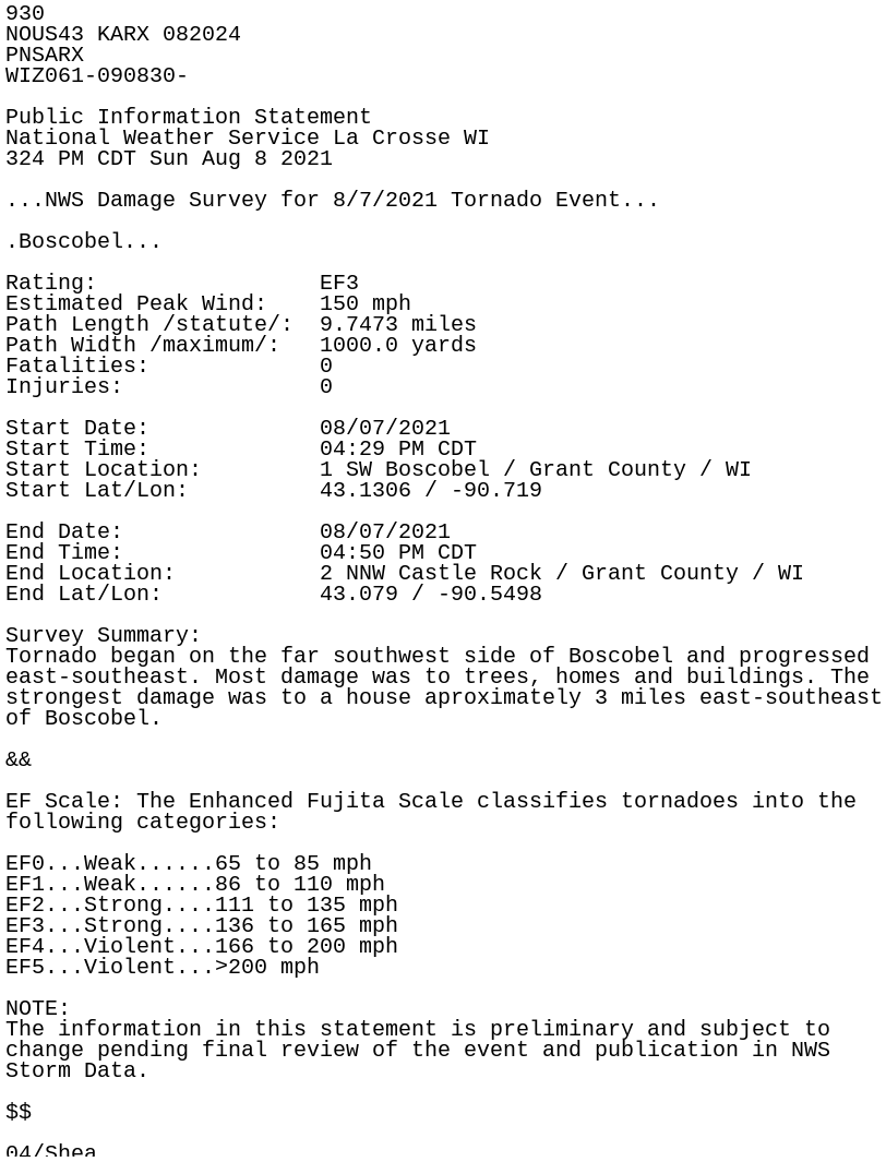
08-Aug-21 04:28 PM
https://mesonet.agron.iastate.edu/wx/afos/p.php?pil=PNSARX&e=202108082024
IEM :: PNS from NWS ARX
PNS issued by NWS ARX at 08 Aug 2021 20:24 UTC
Exported 24 message(s)

")
")
")
")

")


")